348:
281:
231:
273:
223:
295:
245:
316:
354:
359:
72:
860:"}},"text\/plain":{"en":{"":"heading"}}},"{\"value\":{\"amount\":\"+22\",\"unit\":\"http:\\\/\\\/www.wikidata.org\\\/entity\\\/Q28390\"},\"type\":\"quantity\"}":{"text\/html":{"en":{"P7787":"22
760:"}},"text\/plain":{"en":{"":"heading"}}},"{\"value\":{\"amount\":\"+22\",\"unit\":\"http:\\\/\\\/www.wikidata.org\\\/entity\\\/Q28390\"},\"type\":\"quantity\"}":{"text\/html":{"en":{"P7787":"22
856:
264:
1121:== {{int:filedesc}} == {{Information |description={{en|1=Mawley Hall Mawley stands on high ground to the east of Cleobury Mortimer, here it is viewed from the south-west. }} |date=2007-06-09 |source=From [http://www.geograph.org.uk/photo/465464 geograph.o
214:
406:– You must give appropriate credit, provide a link to the license, and indicate if changes were made. You may do so in any reasonable manner, but not in any way that suggests the licensor endorses you or your use.
43:
857:
757:
83:
51:
1135:
1140:
843:
658:
622:
586:
288:
238:
678:
1312:
323:
1186:
This file contains additional information, probably added from the digital camera or scanner used to create or digitize it.
413:
549:
1035:
998:
964:
927:
898:
871:
827:
798:
771:
701:
642:
570:
542:
529:
514:
729:
686:
671:
606:
487:
470:
310:
126:
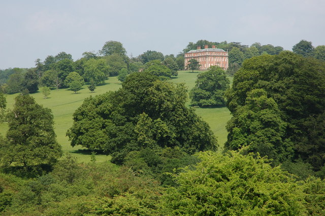
Mawley Hall Mawley stands on high ground to the east of
Cleobury Mortimer, here it is viewed from the south-west.
369:
1189:
If the file has been modified from its original state, some details may not fully reflect the modified file.
1103:
1098:
42:
1131:
The following pages on the
English Knowledge (XXG) use this file (pages on other projects are not listed):
1339:
412:– If you remix, transform, or build upon the material, you must distribute your contributions under the
330:
on the
Geograph website for the photographer's contact details. The copyright on this image is owned by
1114:
366:
1375:
864:"}},"text\/plain":{"en":{"P7787":"22 degree"}}}}": -->
764:"}},"text\/plain":{"en":{"P7787":"22 degree"}}}}": -->
91:
183:
1480:
1281:
1198:
708:
693:
521:
167:
294:
244:
1443:
1357:
1215:
335:
78:
1163:
1490:
1453:
1244:
1409:
1145:
135:
1208:
278:
228:
156:
146:
1500:
1225:
315:
327:
1071:
Click on a date/time to view the file as it appeared at that time.
280:
230:
255:
205:
66:
265:
52° 22′ 28″ N, 2° 27′ 32″ W
215:
52° 22′ 11″ N, 2° 27′ 46″ W
454:
Add a one-line explanation of what this file represents
1173:
110:
90:
Commons is a freely licensed media file repository.
623:
Creative
Commons Attribution-ShareAlike 2.0 Generic
56:(640 × 426 pixels, file size: 133 KB, MIME type:
1380:Flash did not fire, compulsory flash suppression
423:https://creativecommons.org/licenses/by-sa/2.0
71:
429:Creative Commons Attribution-Share Alike 2.0
347:
8:
861:
761:
389:– to copy, distribute and transmit the work
1191:
1073:
450:
116:Mawley Hall - geograph.org.uk - 465464.jpg
52:Mawley_Hall_-_geograph.org.uk_-_465464.jpg
1156:The following other wikis use this file:
694:https://www.geograph.org.uk/photo/465464
522:https://www.geograph.org.uk/profile/1837
1508:
1498:
1488:
1478:
1470:
1462:
1451:
1441:
1433:
1425:
1417:
1407:
1399:
1391:
1383:
1373:
1365:
1355:
1347:
1337:
1329:
1321:
1310:
1302:
1294:
1286:
1276:
1268:
1260:
1252:
1241:
1233:
1223:
1213:
1203:
1133:
1049:
1033:
1012:
996:
978:
962:
941:
925:
885:
869:
841:
825:
785:
769:
743:
727:
656:
640:
620:
604:
584:
568:
501:
485:
468:
465:
446:
439:
258:
208:
1164:Grade I listed buildings in Shropshire
1136:Grade I listed buildings in Shropshire
287:View this and other nearby images on:
237:View this and other nearby images on:
1193:
1141:Listed buildings in Cleobury Mortimer
7:
334:and is licensed for reuse under the
1062:
370:Attribution-Share Alike 2.0 Generic
358:
353:
338:Attribution-ShareAlike 2.0 license.
1184:
459:
453:
344:
321:
120:
103:
49:
458:
1235:Date and time of data generation
772:coordinates of the point of view
444:
400:Under the following conditions:
365:This file is licensed under the
357:
352:
346:
314:
293:
279:
271:
243:
229:
221:
70:
31:
21:
441:
121:
46:No higher resolution available.
14:
659:file available on the internet
440:
322:This image was taken from the
26:
1:
872:coordinates of depicted place
36:
1401:DateTimeDigitized subseconds
679:Geograph Britain and Ireland
543:object of statement has role
466:Items portrayed in this file
1393:DateTimeOriginal subseconds
1323:Date and time of digitizing
1160:Usage on dag.wikipedia.org
887:52°22'27.98"N, 2°27'32.04"W
787:52°22'11.42"N, 2°27'46.08"W
270:
220:
196:Philip Halling /
177:Philip Halling /
1530:
1464:Focal length in 35 mm film
1422:One-chip color area sensor
1170:Usage on www.wikidata.org
414:same or compatible license
1288:File change date and time
1063:
16:
702:geograph.org.uk image ID
443:
380:
77:This is a file from the
1427:Custom image processing
1120:
168:required by the license
152:
141:
134:
131:
113:
81:. Information from its
1510:Subject distance range
1331:Image compression mode
1099:19:14, 4 February 2011
328:this photograph's page
299:52.374440; -2.458900
249:52.369840; -2.462800
84:description page there
1349:Maximum land aperture
1262:Horizontal resolution
1385:DateTime subseconds
1296:Y and C positioning
1270:Vertical resolution
1195:Camera manufacturer
395:– to adapt the work
1472:Scene capture type
1448:Auto white balance
1326:13:40, 9 June 2007
1291:13:40, 9 June 2007
1238:13:40, 9 June 2007
530:author name string
1517:
1516:
1352:4.3 APEX (f/4.44)
1220:1/200 sec (0.005)
1199:NIKON CORPORATION
1152:Global file usage
1124:
863:
763:
607:copyright license
452:
343:
342:
326:collection. See
304:
303:
254:
253:
203:
202:
171:
99:
98:
79:Wikimedia Commons
32:Global file usage
1521:
1304:Exposure Program
1192:
1111:
1017:
946:
909:
908:
903:
809:
808:
803:
711:
706:
696:
691:
687:described at URL
681:
676:
571:copyright status
552:
547:
537:
534:
524:
519:
436:
433:
430:
427:
424:
416:as the original.
378:
367:Creative Commons
361:
360:
356:
355:
350:
349:
336:Creative Commons
324:Geograph project
318:
311:
300:
297:
283:
282:
276:
275:
274:
268:
267:
256:
250:
247:
233:
232:
226:
225:
224:
218:
217:
206:
165:
137:
125:
117:
111:
95:
74:
73:
67:
61:
59:
1529:
1528:
1524:
1523:
1522:
1520:
1519:
1518:
1180:
1150:
1132:
1125:
1117:
1109:
1065:
1064:
1061:
1060:
1059:
1058:
1057:
1056:
1055:
1054:
1052:
1042:
1041:
1040:
1038:
1027:
1026:
1025:
1024:
1023:
1022:
1021:
1020:
1018:
1015:
1005:
1004:
1003:
1001:
990:
989:
988:
987:
986:
985:
984:
983:
981:
971:
970:
969:
967:
956:
955:
954:
953:
952:
951:
950:
949:
947:
944:
934:
933:
932:
930:
919:
918:
917:
916:
915:
914:
913:
912:
911:
910:
906:
904:
901:
892:
891:
890:
888:
878:
877:
876:
874:
855:
854:
853:
852:
851:
850:
849:
848:
846:
834:
833:
832:
830:
819:
818:
817:
816:
815:
814:
813:
812:
811:
810:
806:
804:
801:
792:
791:
790:
788:
778:
777:
776:
774:
755:
754:
753:
752:
751:
750:
749:
748:
746:
736:
735:
734:
732:
721:
720:
719:
718:
717:
716:
715:
714:
713:
712:
707:
704:
698:
697:
692:
689:
683:
682:
677:
674:
665:
664:
663:
661:
649:
648:
647:
645:
634:
633:
632:
631:
630:
629:
628:
627:
625:
613:
612:
611:
609:
598:
597:
596:
595:
594:
593:
592:
591:
589:
577:
576:
575:
573:
562:
561:
560:
559:
558:
557:
556:
555:
554:
553:
548:
545:
539:
538:
535:
532:
526:
525:
520:
517:
508:
507:
506:
504:
494:
493:
492:
490:
479:
478:
477:
476:
475:
473:
457:
456:
455:
438:
437:
434:
431:
428:
425:
422:
421:
379:
376:
373:
362:
339:
309:
298:
272:
263:
262:
259:Object location
248:
222:
213:
212:
209:Camera location
204:
193:
186:
174:
147:geograph.org.uk
127:
115:
108:
101:
100:
89:
88:
87:is shown below.
63:
57:
55:
48:
47:
12:
11:
5:
1527:
1525:
1515:
1514:
1511:
1507:
1506:
1503:
1497:
1496:
1493:
1487:
1486:
1483:
1477:
1476:
1473:
1469:
1468:
1465:
1461:
1460:
1457:
1450:
1449:
1446:
1440:
1439:
1436:
1432:
1431:
1430:Normal process
1428:
1424:
1423:
1420:
1419:Sensing method
1416:
1415:
1412:
1406:
1405:
1402:
1398:
1397:
1394:
1390:
1389:
1386:
1382:
1381:
1378:
1372:
1371:
1368:
1364:
1363:
1360:
1354:
1353:
1350:
1346:
1345:
1342:
1336:
1335:
1332:
1328:
1327:
1324:
1320:
1319:
1316:
1309:
1308:
1305:
1301:
1300:
1297:
1293:
1292:
1289:
1285:
1284:
1279:
1275:
1274:
1271:
1267:
1266:
1263:
1259:
1258:
1255:
1251:
1250:
1247:
1240:
1239:
1236:
1232:
1231:
1228:
1222:
1221:
1218:
1212:
1211:
1206:
1202:
1201:
1196:
1183:
1179:
1178:
1177:
1176:
1168:
1167:
1166:
1154:
1153:
1149:
1148:
1143:
1138:
1130:
1129:
1128:
1123:
1122:
1119:
1115:
1112:
1106:
1101:
1096:
1092:
1091:
1088:
1085:
1082:
1079:
1076:
1069:
1068:
1053:
1050:
1048:
1047:
1046:
1045:
1044:
1043:
1039:
1034:
1032:
1031:
1030:
1029:
1028:
1019:
1013:
1011:
1010:
1009:
1008:
1007:
1006:
1002:
997:
995:
994:
993:
992:
991:
982:
979:
977:
976:
975:
974:
973:
972:
968:
963:
961:
960:
959:
958:
957:
948:
942:
940:
939:
938:
937:
936:
935:
931:
926:
924:
923:
922:
921:
920:
897:
896:
895:
894:
893:
889:
886:
884:
883:
882:
881:
880:
879:
875:
870:
868:
867:
866:
865:
859:
847:
842:
840:
839:
838:
837:
836:
835:
831:
826:
824:
823:
822:
821:
820:
797:
796:
795:
794:
793:
789:
786:
784:
783:
782:
781:
780:
779:
775:
770:
768:
767:
766:
765:
759:
747:
744:
742:
741:
740:
739:
738:
737:
733:
728:
726:
725:
724:
723:
722:
700:
699:
685:
684:
670:
669:
668:
667:
666:
662:
657:
655:
654:
653:
652:
651:
650:
646:
643:source of file
641:
639:
638:
637:
636:
635:
626:
621:
619:
618:
617:
616:
615:
614:
610:
605:
603:
602:
601:
600:
599:
590:
585:
583:
582:
581:
580:
579:
578:
574:
569:
567:
566:
565:
564:
563:
541:
540:
536:Philip Halling
528:
527:
513:
512:
511:
510:
509:
505:
502:
500:
499:
498:
497:
496:
495:
491:
486:
484:
483:
482:
481:
480:
474:
469:
467:
464:
463:
462:
461:
460:
449:
448:
445:
442:
420:
419:
418:
417:
407:
398:
397:
396:
390:
383:You are free:
377:Philip Halling
374:
364:
363:
345:
341:
340:
332:Philip Halling
319:
308:
305:
302:
301:
291:
285:
260:
252:
251:
241:
235:
210:
201:
200:
194:
191:
188:
187:
182:
175:
172:
160:
159:
157:Philip Halling
154:
150:
149:
143:
139:
138:
133:
129:
128:
118:
109:
107:
104:
102:
97:
96:
75:
65:
64:
45:
41:
40:
39:
34:
29:
24:
19:
13:
10:
9:
6:
4:
3:
2:
1526:
1512:
1509:
1504:
1502:
1499:
1494:
1492:
1489:
1484:
1482:
1479:
1474:
1471:
1466:
1463:
1458:
1455:
1452:
1447:
1445:
1444:White balance
1442:
1438:Auto exposure
1437:
1435:Exposure mode
1434:
1429:
1426:
1421:
1418:
1413:
1411:
1408:
1403:
1400:
1395:
1392:
1387:
1384:
1379:
1377:
1374:
1369:
1366:
1361:
1359:
1358:Metering mode
1356:
1351:
1348:
1343:
1341:
1340:Exposure bias
1338:
1333:
1330:
1325:
1322:
1317:
1314:
1311:
1306:
1303:
1298:
1295:
1290:
1287:
1283:
1280:
1278:Software used
1277:
1272:
1269:
1264:
1261:
1256:
1253:
1248:
1246:
1242:
1237:
1234:
1229:
1227:
1224:
1219:
1217:
1216:Exposure time
1214:
1210:
1207:
1204:
1200:
1197:
1194:
1190:
1187:
1181:
1175:
1172:
1171:
1169:
1165:
1162:
1161:
1159:
1158:
1157:
1151:
1147:
1144:
1142:
1139:
1137:
1134:
1126:
1118:
1113:
1107:
1105:
1102:
1100:
1097:
1094:
1093:
1089:
1086:
1083:
1080:
1077:
1075:
1074:
1072:
1066:
1037:
1000:
966:
929:
928:exposure time
900:
873:
845:
829:
828:captured with
800:
773:
731:
710:
703:
695:
688:
680:
673:
660:
644:
624:
608:
588:
572:
551:
544:
531:
523:
516:
489:
472:
426:CC BY-SA 2.0
415:
411:
408:
405:
402:
401:
399:
394:
391:
388:
385:
384:
382:
381:
375:Attribution:
371:
368:
351:
337:
333:
329:
325:
320:
317:
313:
312:
306:
296:
292:
290:
289:OpenStreetMap
286:
284:
266:
261:
257:
246:
242:
240:
239:OpenStreetMap
236:
234:
216:
211:
207:
199:
195:
190:
189:
185:
181: /
180:
176:
169:
164:
162:
161:
158:
155:
151:
148:
144:
140:
130:
124:
119:
112:
105:
93:
86:
85:
80:
76:
69:
68:
62:
53:
44:
38:
35:
33:
30:
28:
25:
23:
20:
18:
15:
1454:Digital zoom
1367:Light source
1245:focal length
1205:Camera model
1188:
1185:
1155:
1070:
1067:File history
999:focal length
550:photographer
409:
403:
392:
386:
331:
269:
219:
197:
184:CC BY-SA 2.0
178:
122:
92:You can help
82:
50:
22:File history
1410:Color space
1307:Not defined
1254:Orientation
1146:Mawley Hall
1116:GeographBot
745:9 June 2007
587:copyrighted
410:share alike
404:attribution
198:Mawley Hall
179:Mawley Hall
163:Attribution
136:9 June 2007
114:Description
1491:Saturation
1209:NIKON D70s
1127:File usage
1108:640 × 426
1084:Dimensions
1051:image/jpeg
1036:media type
1016:millimetre
844:Nikon D70s
503:some value
58:image/jpeg
27:File usage
1501:Sharpness
1475:Landscape
1282:Ver.1.00
1081:Thumbnail
1078:Date/Time
730:inception
307:Licensing
192:InfoField
173:InfoField
123:English:
1481:Contrast
1299:Co-sited
1226:F-number
1182:Metadata
1174:Q6794435
1110:(133 KB)
965:f-number
672:operator
447:Captions
393:to remix
387:to share
372:license.
37:Metadata
1513:Unknown
1370:Unknown
1362:Pattern
1315:version
1273:300 dpi
1265:300 dpi
1095:current
1090:Comment
899:heading
858:heading
799:heading
758:heading
488:creator
471:depicts
451:English
106:Summary
54:
1495:Normal
1485:Normal
1467:105 mm
1257:Normal
945:second
943:0.005
907:degree
862:degree
807:degree
762:degree
709:465464
277:
227:
153:Author
142:Source
1456:ratio
1376:Flash
1249:70 mm
1243:Lens
145:From
1505:Hard
1414:sRGB
1318:2.21
1313:Exif
1230:f/10
1087:User
435:true
432:true
132:Date
17:File
1014:70
905:22
805:22
515:URL
1404:00
1396:00
1388:00
980:10
902::
802::
705::
690::
675::
546::
533::
518::
1459:1
1344:0
1334:2
170:)
166:(
94:.
60:)
Text is available under the Creative Commons Attribution-ShareAlike License. Additional terms may apply.
_heading:22.00&language=en)
_heading:22.00&language=en)
