248:
43:
254:
259:
99:
684:
701:{{Information |Description={{de|Physische Positionskarte von {{w|Mali|3=de}}}} Quadratische Plattkarte, N-S-Streckung 105 %. Geographische Begrenzung der Karte: * N: 25.5° N * S: 9.7° N * W: 12.6° W * O: 4.8° O {{en|Physical location map of {{w|Mali}}
300:– You must give appropriate credit, provide a link to the license, and indicate if changes were made. You may do so in any reasonable manner, but not in any way that suggests the licensor endorses you or your use.
850:
1128:
1277:
948:
1083:
1013:
344:
1003:
65:
237:
61:
57:
53:
47:
110:
930:
1058:
760:
78:
629:
559:
523:
805:
1288:
This file contains additional information, probably added from the digital camera or scanner used to create or digitize it.
307:
925:
443:
785:
755:
613:
507:
479:
464:
451:
436:
1053:
579:
543:
409:
392:
910:
815:
471:
269:
1291:
If the file has been modified from its original state, some details may not fully reflect the modified file.
790:
725:
715:
711:
The following pages on the
English Knowledge (XXG) use this file (pages on other projects are not listed):
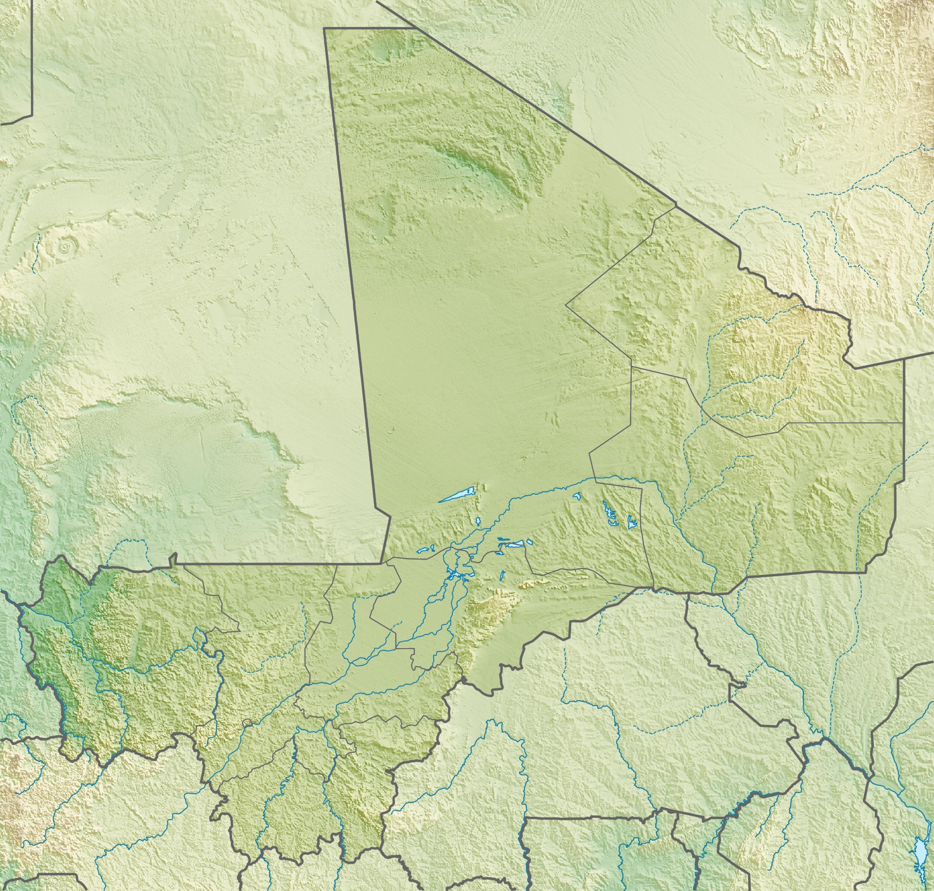
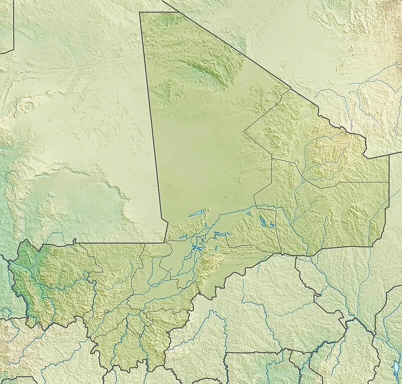
218:, using map data from administrative map by NordNordWest. The relief was created from SRTM-30 relief data
973:
800:
795:
745:
306:– If you remix, transform, or build upon the material, you must distribute your contributions under the
1068:
920:
915:
730:
266:
1138:
968:
1078:
905:
770:
845:
694:
118:
885:
750:
880:
775:
720:
683:
678:
69:
42:
1208:
1048:
486:
765:
958:
875:
865:
840:
830:
780:
154:
Quadratische
Plattkarte, N-S-Streckung 105 %. Geographische Begrenzung der Karte:
1108:
895:
860:
855:
182:
Equirectangular projection, N/S stretching 105 %. Geographic limits of the map:
105:
983:
890:
820:
810:
735:
825:
1033:
205:
1103:
1093:
835:
226:
870:
1063:
1028:
177:
1258:
1163:
1118:
900:
149:
1203:
1218:
1153:
1018:
740:
988:
651:
Click on a date/time to view the file as it appeared at that time.
1263:
1183:
1043:
1038:
993:
93:
1248:
1238:
1253:
1233:
1268:
1243:
1213:
1198:
1148:
1193:
376:
Add a one-line explanation of what this file represents
1228:
1209:
Knowledge (XXG):Kartenwerkstatt/Positionskarten/Afrika
83:(1,900 × 1,812 pixels, file size: 1.72 MB, MIME type:
1223:
1178:
1188:
560:
Creative
Commons Attribution-ShareAlike 3.0 Unported
132:
117:
Commons is a freely licensed media file repository.
1173:
851:List of fossiliferous stratigraphic units in Mali
317:https://creativecommons.org/licenses/by-sa/3.0
98:
323:Creative Commons Attribution-Share Alike 3.0
247:
8:
974:Módulu:Mapa de llocalización/datos/Malí/usu
283:– to copy, distribute and transmit the work
1293:
653:
372:
941:The following other wikis use this file:
487:http://commons.wikimedia.org/User:Carport
343:
1295:
969:Módulu:Mapa de llocalización/datos/Malí
713:
627:
611:
593:
577:
557:
541:
521:
505:
423:
407:
390:
387:
368:
361:
340:
7:
270:Attribution-Share Alike 3.0 Unported
642:
352:Equivalent administrative de la map
346:Equivalent administrative de la map
258:
253:
1286:
381:
375:
244:
170:
142:
130:
76:
931:Module:Location map/data/Mali/doc
380:
366:
294:Under the following conditions:
265:This file is licensed under the
257:
252:
246:
97:
31:
21:
1109:Mòdul:Location map/data/Mali/ús
806:Hand of Fatima (rock formation)
363:
171:
14:
761:Boucle du Baoulé National Park
362:
143:
26:
1:
1259:Liste von Kraftwerken in Mali
926:Module:Location map/data/Mali
630:original creation by uploader
148:Physische Positionskarte von
36:
1164:Skabelon:Kortpositioner Mali
1104:Mòdul:Location map/data/Mali
1094:Šablon:Lokacijska karta Mali
756:Battle of Tinzaouaten (2024)
437:object of statement has role
388:Items portrayed in this file
138:Mali relief location map.jpg
1204:Vorlage:Positionskarte Mali
1135:Usage on ckb.wikipedia.org
1119:Plantilya:Location map Mali
1115:Usage on ceb.wikipedia.org
965:Usage on ast.wikipedia.org
955:Usage on arz.wikipedia.org
1317:
1170:Usage on de.wikipedia.org
1160:Usage on da.wikipedia.org
1145:Usage on cs.wikipedia.org
1125:Usage on ce.wikipedia.org
1100:Usage on ca.wikipedia.org
1090:Usage on bs.wikipedia.org
1075:Usage on bn.wikipedia.org
1025:Usage on bg.wikipedia.org
1010:Usage on be.wikipedia.org
1000:Usage on ba.wikipedia.org
980:Usage on az.wikipedia.org
945:Usage on ar.wikipedia.org
308:same or compatible license
911:User:Crtew/Yameen Rasheed
786:Félou Hydroelectric Plant
643:
215:
176:Physical location map of
16:
1219:Benutzer:Carport/Galerie
1139:داڕێژە:Location map Mali
984:Şablon:Yer xəritəsi Mali
816:Kouroufing National Park
365:
274:
104:This is a file from the
1129:Кеп:Меттиган карта Мали
700:
336:
232:
222:
211:
204:
201:
135:
108:. Information from its
959:قالب:Location map Mali
791:Grand Mosque of Bamako
726:Badinko Faunal Reserve
716:2022 Bankass massacres
111:description page there
46:Size of this preview:
949:قالب:خريطة مواقع مالي
801:Great Mosque of Niono
796:Grand Mosque of Mopti
746:Bandiagara Escarpment
1014:Шаблон:На карце/Малі
921:User:Kwjjeon/tommoso
916:User:Kwjjeon/sandbox
731:Bafing National Park
70:1,900 × 1,812 pixels
66:1,074 × 1,024 pixels
1184:Manantali-Talsperre
1154:Šablona:LocMap Mali
1004:Ҡалып:ПозКарта Мали
906:Wongo National Park
771:Djinguereber Mosque
289:– to adapt the work
52:Other resolutions:
989:Bandiaqara uçurumu
465:Wikimedia username
452:author name string
1304:
1303:
1278:more global usage
937:Global file usage
881:Sidi Yahya Mosque
721:Augustin Hacquard
704:
679:15:22, 6 May 2010
544:copyright license
374:
359:
358:
241:
238:Reusing this file
126:
125:
106:Wikimedia Commons
32:Global file usage
1308:
1294:
1239:Welterbe in Mali
1059:Адрар дез Ифогас
691:
508:copyright status
489:
484:
474:
469:
459:
456:
446:
441:
349:
347:
330:
327:
324:
321:
318:
310:as the original.
267:Creative Commons
261:
260:
256:
255:
250:
249:
235:
217:
207:
175:
147:
139:
133:
122:
101:
100:
94:
88:
86:
73:
62:805 × 768 pixels
58:503 × 480 pixels
54:252 × 240 pixels
48:629 × 600 pixels
1316:
1315:
1311:
1310:
1309:
1307:
1306:
1305:
1282:
1264:Kraftwerk Félou
935:
751:Battle of Jenné
712:
705:
697:
689:
645:
644:
641:
640:
639:
638:
637:
636:
635:
634:
632:
620:
619:
618:
616:
605:
604:
603:
602:
601:
600:
599:
598:
596:
586:
585:
584:
582:
571:
570:
569:
568:
567:
566:
565:
564:
562:
550:
549:
548:
546:
535:
534:
533:
532:
531:
530:
529:
528:
526:
514:
513:
512:
510:
499:
498:
497:
496:
495:
494:
493:
492:
491:
490:
485:
482:
476:
475:
470:
467:
461:
460:
457:
454:
448:
447:
442:
439:
430:
429:
428:
426:
416:
415:
414:
412:
401:
400:
399:
398:
397:
395:
379:
378:
377:
360:
353:
350:
345:
332:
331:
328:
325:
322:
319:
316:
315:
273:
262:
180:
152:
137:
128:
127:
116:
115:
114:is shown below.
90:
84:
82:
75:
74:
51:
12:
11:
5:
1314:
1312:
1302:
1301:
1298:
1285:
1280:of this file.
1274:
1273:
1272:
1271:
1266:
1261:
1256:
1254:Ber (Timbuktu)
1251:
1246:
1241:
1236:
1231:
1226:
1221:
1216:
1211:
1206:
1201:
1196:
1191:
1186:
1181:
1176:
1168:
1167:
1166:
1158:
1157:
1156:
1151:
1143:
1142:
1141:
1133:
1132:
1131:
1123:
1122:
1121:
1113:
1112:
1111:
1106:
1098:
1097:
1096:
1088:
1087:
1086:
1084:মপতি বড় মসজিদ
1081:
1073:
1072:
1071:
1066:
1061:
1056:
1054:Шаблон:ПК Мали
1051:
1046:
1041:
1036:
1031:
1023:
1022:
1021:
1016:
1008:
1007:
1006:
998:
997:
996:
991:
986:
978:
977:
976:
971:
963:
962:
961:
953:
952:
951:
939:
938:
934:
933:
928:
923:
918:
913:
908:
903:
898:
893:
888:
883:
878:
876:Paul Soleillet
873:
868:
866:Moura massacre
863:
858:
853:
848:
843:
841:Lake Manantali
838:
833:
831:Lake Faguibine
828:
823:
818:
813:
808:
803:
798:
793:
788:
783:
778:
776:Eugène Bonnier
773:
768:
763:
758:
753:
748:
743:
738:
733:
728:
723:
718:
710:
709:
708:
703:
702:
699:
695:
692:
688:1,900 × 1,812
686:
681:
676:
672:
671:
668:
665:
662:
659:
656:
649:
648:
633:
628:
626:
625:
624:
623:
622:
621:
617:
614:source of file
612:
610:
609:
608:
607:
606:
597:
594:
592:
591:
590:
589:
588:
587:
583:
578:
576:
575:
574:
573:
572:
563:
558:
556:
555:
554:
553:
552:
551:
547:
542:
540:
539:
538:
537:
536:
527:
522:
520:
519:
518:
517:
516:
515:
511:
506:
504:
503:
502:
501:
500:
478:
477:
463:
462:
450:
449:
435:
434:
433:
432:
431:
427:
424:
422:
421:
420:
419:
418:
417:
413:
408:
406:
405:
404:
403:
402:
396:
391:
389:
386:
385:
384:
383:
382:
371:
370:
367:
364:
357:
356:
355:
354:
351:
342:
338:
337:Other versions
334:
333:
314:
313:
312:
311:
301:
292:
291:
290:
284:
277:You are free:
264:
263:
245:
242:
230:
229:
224:
220:
219:
213:
209:
208:
203:
199:
198:
197:
196:
193:
190:
187:
169:
168:
165:
162:
159:
140:
131:
129:
124:
123:
102:
92:
91:
45:
41:
40:
39:
34:
29:
24:
19:
13:
10:
9:
6:
4:
3:
2:
1313:
1299:
1296:
1292:
1289:
1283:
1281:
1279:
1270:
1269:Manantali-See
1267:
1265:
1262:
1260:
1257:
1255:
1252:
1250:
1247:
1245:
1244:Kabara (Mali)
1242:
1240:
1237:
1235:
1232:
1230:
1227:
1225:
1222:
1220:
1217:
1215:
1212:
1210:
1207:
1205:
1202:
1200:
1199:Hombori Tondo
1197:
1195:
1192:
1190:
1187:
1185:
1182:
1180:
1177:
1175:
1172:
1171:
1169:
1165:
1162:
1161:
1159:
1155:
1152:
1150:
1149:Hombori Tondo
1147:
1146:
1144:
1140:
1137:
1136:
1134:
1130:
1127:
1126:
1124:
1120:
1117:
1116:
1114:
1110:
1107:
1105:
1102:
1101:
1099:
1095:
1092:
1091:
1089:
1085:
1082:
1080:
1077:
1076:
1074:
1070:
1067:
1065:
1062:
1060:
1057:
1055:
1052:
1050:
1047:
1045:
1042:
1040:
1037:
1035:
1032:
1030:
1027:
1026:
1024:
1020:
1017:
1015:
1012:
1011:
1009:
1005:
1002:
1001:
999:
995:
992:
990:
987:
985:
982:
981:
979:
975:
972:
970:
967:
966:
964:
960:
957:
956:
954:
950:
947:
946:
944:
943:
942:
936:
932:
929:
927:
924:
922:
919:
917:
914:
912:
909:
907:
904:
902:
899:
897:
896:Tomb of Askia
894:
892:
889:
887:
884:
882:
879:
877:
874:
872:
869:
867:
864:
862:
861:Mount Hombori
859:
857:
856:Manantali Dam
854:
852:
849:
847:
846:Lake Sélingué
844:
842:
839:
837:
834:
832:
829:
827:
824:
822:
819:
817:
814:
812:
809:
807:
804:
802:
799:
797:
794:
792:
789:
787:
784:
782:
779:
777:
774:
772:
769:
767:
766:Djenné-Djenno
764:
762:
759:
757:
754:
752:
749:
747:
744:
742:
739:
737:
734:
732:
729:
727:
724:
722:
719:
717:
714:
706:
698:
693:
687:
685:
682:
680:
677:
674:
673:
669:
666:
663:
660:
657:
655:
654:
652:
646:
631:
615:
581:
561:
545:
525:
509:
488:
481:
473:
466:
453:
445:
438:
411:
394:
348:
341:
339:
335:
320:CC BY-SA 3.0
309:
305:
302:
299:
296:
295:
293:
288:
285:
282:
279:
278:
276:
275:
271:
268:
251:
243:
239:
234:
231:
228:
225:
221:
214:
210:
200:
194:
191:
188:
185:
184:
183:
179:
174:
166:
163:
160:
157:
156:
155:
151:
146:
141:
134:
120:
113:
112:
107:
103:
96:
95:
89:
80:
79:Original file
71:
67:
63:
59:
55:
49:
44:
38:
35:
33:
30:
28:
25:
23:
20:
18:
15:
1290:
1287:
1275:
1069:Мопти (град)
994:Adrar-İforas
940:
891:Tireli, Mali
886:Sélingué Dam
821:Kukiya, Mali
811:Kabara, Mali
736:Bafing River
650:
647:File history
444:photographer
303:
297:
286:
280:
181:
172:
153:
144:
119:You can help
109:
77:
22:File history
1194:Gossi (See)
781:Félou Falls
524:copyrighted
304:share alike
298:attribution
136:Description
1297:_error
836:Lake Gossi
707:File usage
664:Dimensions
595:6 May 2010
425:some value
233:Permission
206:6 May 2010
192:W: 12.6° W
186:N: 25.5° N
164:W: 12.6° W
158:N: 25.5° N
85:image/jpeg
27:File usage
1234:Diafarabé
1229:Faguibine
871:Ounjougou
826:Lake Débo
690:(1.72 MB)
661:Thumbnail
658:Date/Time
580:inception
195:E: 4.8° E
189:S: 9.7° N
173:English:
167:O: 4.8° O
161:S: 9.7° N
145:Deutsch:
1284:Metadata
1224:Adjelhoc
1214:Débo-See
1179:Timbuktu
1049:Тимбукту
901:Tommo So
369:Captions
287:to remix
281:to share
272:license.
216:Own work
178:Malienne
150:Malienne
37:Metadata
1189:Massina
696:Carport
675:current
670:Comment
472:Carport
458:Carport
410:creator
393:depicts
373:English
227:Carport
81:
1249:Téméra
1079:বামাকো
1034:Бамако
741:Bamako
223:Author
212:Source
1276:View
1064:Кайес
1029:Джене
1174:Mali
1019:Бані
667:User
329:true
326:true
202:Date
17:File
1044:Бла
1039:Гао
480:URL
483::
468::
455::
440::
68:|
64:|
60:|
56:|
50:.
1300:0
240:)
236:(
121:.
87:)
72:.
Text is available under the Creative Commons Attribution-ShareAlike License. Additional terms may apply.