207:
43:
213:
218:
103:
715:{{Information |Description= Mangoky Basin_OSM. Based on US military map Se-SF38-39 |Source= https://maps-for-free.com, http://legacy.lib.utexas.edu/maps/ams/africa_1m/ |Date= 2021-04-01 |Author= Hans Braxmeier & Peter in s |Permission= |other_versions= }} {{cc-by-sa-2.0}}
698:
259:– You must give appropriate credit, provide a link to the license, and indicate if changes were made. You may do so in any reasonable manner, but not in any way that suggests the licensor endorses you or your use.
531:
409:
392:
356:
869:
This file contains additional information, probably added from the digital camera or scanner used to create or digitize it.
722:
719:
266:
69:
65:
61:
57:
53:
47:
626:
589:
552:
497:
463:
340:
114:
524:
429:
376:
323:
177:
82:
228:
872:
If the file has been modified from its original state, some details may not fully reflect the modified file.
734:
The following pages on the
English Knowledge (XXG) use this file (pages on other projects are not listed):
265:– If you remix, transform, or build upon the material, you must distribute your contributions under the
716:
225:
122:
900:
187:
708:
758:
697:
692:
195:
73:
42:
748:
743:
109:
191:
173:
781:
738:
159:
753:
665:
Click on a date/time to view the file as it appeared at that time.
831:
836:
97:
169:
856:
841:
791:
816:
811:
801:
307:
Add a one-line explanation of what this file represents
87:(3,024 × 2,230 pixels, file size: 12.51 MB, MIME type:
846:
821:
151:
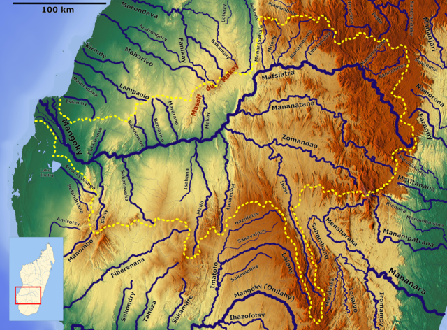
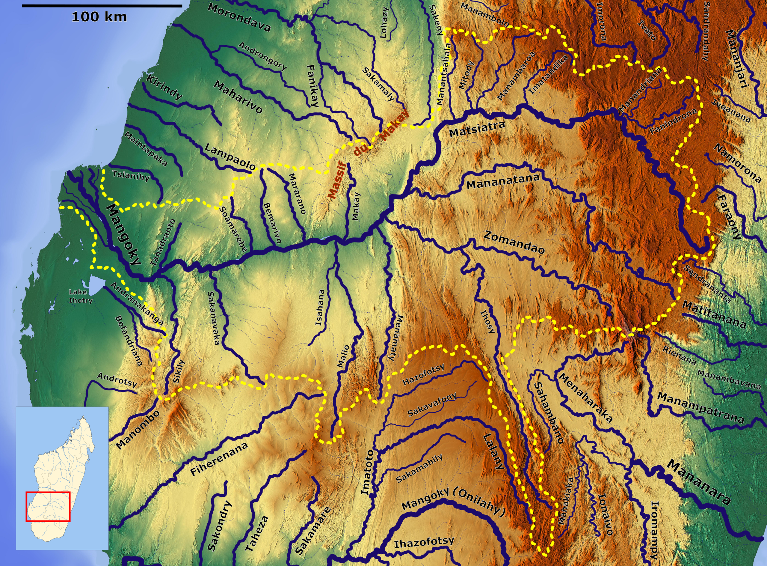
Mangoky Basin_OSM. Based on US military map Se-SF38-39
776:
410:
Creative
Commons Attribution-ShareAlike 3.0 Unported
141:
121:
Commons is a freely licensed media file repository.
393:
Creative
Commons Attribution-ShareAlike 2.0 Generic
174:http://legacy.lib.utexas.edu/maps/ams/africa_1m/
276:https://creativecommons.org/licenses/by-sa/3.0
102:
282:Creative Commons Attribution-Share Alike 3.0
206:
8:
242:– to copy, distribute and transmit the work
874:
667:
303:
769:The following other wikis use this file:
513:beeb2d2b67a7c34fccaf7ce539bae7a5b4664fda
897:
892:
884:
876:
736:
640:
624:
603:
587:
566:
550:
511:
495:
477:
461:
443:
427:
407:
390:
374:
354:
338:
321:
318:
299:
292:
723:Category:Drainage basin maps of Africa
720:Category:Maps of rivers of Madagascar
7:
229:Attribution-Share Alike 3.0 Unported
656:
217:
212:
867:
312:
306:
203:
134:
80:
311:
297:
253:Under the following conditions:
224:This file is licensed under the
216:
211:
205:
178:File:Madagascar location map.svg
101:
31:
21:
294:
14:
782:Liste der Flüsse in Madagaskar
293:
26:
1:
36:
319:Items portrayed in this file
922:
853:Usage on sl.wikipedia.org
828:Usage on ro.wikipedia.org
808:Usage on ha.wikipedia.org
798:Usage on fr.wikipedia.org
788:Usage on ff.wikipedia.org
773:Usage on de.wikipedia.org
267:same or compatible license
657:
170:https://maps-for-free.com
16:
296:
233:
108:This is a file from the
714:
183:
165:
158:
155:
144:
112:. Information from its
115:description page there
46:Size of this preview:
878:Horizontal resolution
147:Mangoky Basin OSM.png
525:determination method
74:3,024 × 2,230 pixels
70:2,560 × 1,888 pixels
886:Vertical resolution
693:07:05, 1 April 2021
248:– to adapt the work
52:Other resolutions:
66:1,280 × 944 pixels
62:1,024 × 755 pixels
909:
908:
765:Global file usage
727:
377:copyright license
305:
201:
200:
130:
129:
110:Wikimedia Commons
32:Global file usage
913:
903:
901:www.inkscape.org
875:
717:Category:Mangoky
705:
645:
608:
571:
534:
529:
341:copyright status
289:
286:
283:
280:
277:
269:as the original.
226:Creative Commons
220:
219:
215:
214:
209:
208:
161:
148:
142:
126:
105:
104:
98:
92:
90:
77:
58:640 × 472 pixels
54:320 × 236 pixels
48:800 × 590 pixels
921:
920:
916:
915:
914:
912:
911:
910:
899:
863:
763:
735:
728:
711:
703:
659:
658:
655:
654:
653:
652:
651:
650:
649:
648:
646:
643:
633:
632:
631:
629:
618:
617:
616:
615:
614:
613:
612:
611:
609:
606:
596:
595:
594:
592:
581:
580:
579:
578:
577:
576:
575:
574:
572:
569:
559:
558:
557:
555:
544:
543:
542:
541:
540:
539:
538:
537:
536:
535:
530:
527:
518:
517:
516:
514:
504:
503:
502:
500:
489:
488:
487:
486:
485:
484:
483:
482:
480:
470:
469:
468:
466:
455:
454:
453:
452:
451:
450:
449:
448:
446:
436:
435:
434:
432:
421:
420:
419:
418:
417:
416:
415:
414:
412:
401:
400:
399:
398:
397:
395:
383:
382:
381:
379:
368:
367:
366:
365:
364:
363:
362:
361:
359:
347:
346:
345:
343:
332:
331:
330:
329:
328:
326:
310:
309:
308:
291:
290:
287:
284:
281:
278:
275:
274:
232:
221:
202:
194:, Location map:
176:, Location map:
146:
139:
132:
131:
120:
119:
118:is shown below.
94:
88:
86:
79:
78:
51:
12:
11:
5:
919:
917:
907:
906:
905:
904:
895:
891:
890:
887:
883:
882:
879:
866:
862:
861:
860:
859:
857:Mangoky (reka)
851:
850:
849:
844:
839:
834:
826:
825:
824:
819:
814:
806:
805:
804:
796:
795:
794:
786:
785:
784:
779:
767:
766:
762:
761:
759:Zomandao River
756:
751:
746:
741:
733:
732:
731:
726:
725:
713:
709:
706:
702:3,024 × 2,230
700:
695:
690:
686:
685:
682:
679:
676:
673:
670:
663:
662:
647:
641:
639:
638:
637:
636:
635:
634:
630:
625:
623:
622:
621:
620:
619:
610:
604:
602:
601:
600:
599:
598:
597:
593:
588:
586:
585:
584:
583:
582:
573:
567:
565:
564:
563:
562:
561:
560:
556:
551:
549:
548:
547:
546:
545:
523:
522:
521:
520:
519:
515:
512:
510:
509:
508:
507:
506:
505:
501:
496:
494:
493:
492:
491:
490:
481:
478:
476:
475:
474:
473:
472:
471:
467:
462:
460:
459:
458:
457:
456:
447:
444:
442:
441:
440:
439:
438:
437:
433:
428:
426:
425:
424:
423:
422:
413:
408:
406:
405:
404:
403:
402:
396:
391:
389:
388:
387:
386:
385:
384:
380:
375:
373:
372:
371:
370:
369:
360:
355:
353:
352:
351:
350:
349:
348:
344:
339:
337:
336:
335:
334:
333:
327:
322:
320:
317:
316:
315:
314:
313:
302:
301:
298:
295:
273:
272:
271:
270:
260:
251:
250:
249:
243:
236:You are free:
223:
222:
204:
199:
198:
188:Hans Braxmeier
185:
181:
180:
167:
163:
162:
157:
153:
152:
149:
140:
138:
135:
133:
128:
127:
106:
96:
95:
45:
41:
40:
39:
34:
29:
24:
19:
13:
10:
9:
6:
4:
3:
2:
918:
902:
898:
896:
894:Software used
893:
888:
885:
880:
877:
873:
870:
864:
858:
855:
854:
852:
848:
845:
843:
842:Mananantanana
840:
838:
835:
833:
832:Râul Zomandao
830:
829:
827:
823:
820:
818:
815:
813:
810:
809:
807:
803:
800:
799:
797:
793:
792:Mananantanana
790:
789:
787:
783:
780:
778:
775:
774:
772:
771:
770:
764:
760:
757:
755:
752:
750:
749:Mangoky River
747:
745:
744:Mananantanana
742:
740:
737:
729:
724:
721:
718:
712:
707:
701:
699:
696:
694:
691:
688:
687:
683:
680:
677:
674:
671:
669:
668:
666:
660:
628:
591:
554:
533:
526:
499:
465:
431:
411:
394:
378:
358:
342:
325:
279:CC BY-SA 3.0
268:
264:
261:
258:
255:
254:
252:
247:
244:
241:
238:
237:
235:
234:
230:
227:
210:
197:
193:
189:
186:
182:
179:
175:
171:
168:
164:
154:
150:
143:
136:
124:
117:
116:
111:
107:
100:
99:
93:
84:
83:Original file
75:
71:
67:
63:
59:
55:
49:
44:
38:
35:
33:
30:
28:
25:
23:
20:
18:
15:
871:
868:
837:Râul Mangoky
817:Mananatanana
768:
664:
661:File history
445:1 April 2021
262:
256:
245:
239:
196:NordNordWest
160:1 April 2021
123:You can help
113:
81:
22:File history
812:Kogin Ihosy
739:Ihosy River
568:13,114,864
357:copyrighted
263:share alike
257:attribution
145:Description
802:Mananatana
730:File usage
710:Peter in s
704:(12.51 MB)
678:Dimensions
464:media type
192:Peter in s
27:File usage
889:37.79 dpc
881:37.79 dpc
847:Matsiatra
822:Matsiatra
754:Matsiatra
675:Thumbnail
672:Date/Time
553:data size
479:image/png
430:inception
89:image/png
865:Metadata
498:checksum
300:Captions
246:to remix
240:to share
231:license.
37:Metadata
777:Mangoky
689:current
684:Comment
324:depicts
304:English
137:Summary
85:
642:3,024
605:2,230
590:height
190:&
184:Author
166:Source
644:pixel
627:width
607:pixel
532:SHA-1
681:User
570:byte
288:true
285:true
156:Date
17:File
528::
172:,
72:|
68:|
64:|
60:|
56:|
50:.
125:.
91:)
76:.
Text is available under the Creative Commons Attribution-ShareAlike License. Additional terms may apply.
