43:
306:
195:
370:
284:
384:
201:
99:
811:
248:– You must give appropriate credit, provide a link to the license, and indicate if changes were made. You may do so in any reasonable manner, but not in any way that suggests the licensor endorses you or your use.
361:
65:
61:
57:
53:
47:
828:
78:
110:
173:
297:
184:
849:
513:
477:
377:
441:
1017:
890:
This file contains additional information, probably added from the digital camera or scanner used to create or digitize it.
688:
742:
638:
601:
567:
533:
461:
708:
497:
425:
163:
672:
1002:
893:
If the file has been modified from its original state, some details may not fully reflect the modified file.
305:
845:
The following pages on the
English Knowledge (XXG) use this file (pages on other projects are not listed):
1057:
810:
805:
211:
69:
42:
208:
1077:
912:
118:
383:
1105:
1067:
105:
1115:
949:
832:
164:
https://web.archive.org/web/20161031004321/http://www.panoramio.com/photo/123306656
367:
1095:
929:
902:
821:
919:
283:
778:
Click on a date/time to view the file as it appeared at that time.
526:
831:
cropped 41 % horizontally, 10 % vertically, rotated 1.79° using
369:
362:
46° 14′ 17.28″ N, 79° 37′ 35.58″ W
352:
93:
867:
409:
Add a one-line explanation of what this file represents
83:(5,513 × 1,814 pixels, file size: 1.74 MB, MIME type:
877:
278:
137:
117:
Commons is a freely licensed media file repository.
1082:Flash did not fire, compulsory flash suppression
98:
194:
8:
255:https://creativecommons.org/licenses/by/3.0
231:– to copy, distribute and transmit the work
895:
780:
405:
860:The following other wikis use this file:
829:File:Manitou Islands Pano - panoramio.jpg
514:Creative Commons Attribution 3.0 Unported
1132:
1124:
1113:
1103:
1093:
1085:
1075:
1065:
1055:
1034:
1026:
1015:
1007:
997:
989:
981:
973:
965:
957:
946:
938:
927:
917:
907:
847:
756:
740:
722:
706:
686:
670:
652:
636:
615:
599:
581:
565:
547:
531:
511:
495:
475:
459:
439:
423:
420:
401:
394:
355:
376:View this and other nearby images on:
897:
7:
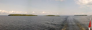
298:Manitou Islands Pano - panoramio.jpg
769:
200:
888:
414:
408:
325:Nipissing, Unorganized, North Part
289:
222:
191:
143:Manitou Islands Pano (cropped).jpg
130:
76:
413:
261:Creative Commons Attribution 3.0
940:Date and time of data generation
850:Manitou Islands (Lake Nipissing)
534:coordinates of the point of view
399:
382:
368:
304:
282:
242:Under the following conditions:
207:This file is licensed under the
199:
193:
97:
31:
21:
396:
14:
549:46°14'17.275"N, 79°37'35.576"W
395:
26:
1:
36:
421:Items portrayed in this file
155:Taken on 30 August 2015
1028:Date and time of digitizing
864:Usage on ceb.wikipedia.org
1154:
1126:Focal length in 35 mm film
1087:Supported Flashpix version
874:Usage on www.wikidata.org
1036:Meaning of each component
770:
16:
398:
212:Attribution 3.0 Unported
104:This is a file from the
1072:Center weighted average
827:
274:
179:
169:
159:
154:
151:
140:
108:. Information from its
1003:BlackBerry 10.3.2.2252
388:46.238132; -79.626549
111:description page there
46:Size of this preview:
1031:13:43, 30 August 2015
983:Horizontal resolution
943:13:43, 30 August 2015
806:18:57, 1 October 2021
147:Manitou Islands Pano
70:5,513 × 1,814 pixels
1009:Y and C positioning
991:Vertical resolution
899:Camera manufacturer
290:This file has been
237:– to adapt the work
52:Other resolutions:
1134:Scene capture type
1110:Auto white balance
913:BlackBerry Classic
835:with precise mode.
66:1,280 × 421 pixels
62:1,024 × 337 pixels
1141:
1140:
856:Global file usage
838:
498:copyright license
407:
393:
392:
350:
349:
313:
312:
294:from another file
188:
185:Reusing this file
126:
125:
106:Wikimedia Commons
32:Global file usage
1145:
896:
818:
620:
462:copyright status
389:
386:
372:
371:
365:
364:
353:
346:
342:
338:
334:
330:
326:
308:
286:
279:
268:
265:
262:
259:
256:
220:
209:Creative Commons
203:
202:
197:
196:
182:
144:
138:
122:
101:
100:
94:
88:
86:
73:
58:640 × 211 pixels
54:320 × 105 pixels
48:800 × 263 pixels
1153:
1152:
1148:
1147:
1146:
1144:
1143:
1142:
884:
868:Manitou Islands
854:
846:
839:
824:
816:
772:
771:
768:
767:
766:
765:
764:
763:
762:
761:
759:
749:
748:
747:
745:
734:
733:
732:
731:
730:
729:
728:
727:
725:
715:
714:
713:
711:
700:
699:
698:
697:
696:
695:
694:
693:
691:
679:
678:
677:
675:
664:
663:
662:
661:
660:
659:
658:
657:
655:
645:
644:
643:
641:
630:
629:
628:
627:
626:
625:
624:
623:
621:
618:
608:
607:
606:
604:
593:
592:
591:
590:
589:
588:
587:
586:
584:
574:
573:
572:
570:
559:
558:
557:
556:
555:
554:
553:
552:
550:
540:
539:
538:
536:
525:
524:
523:
522:
521:
520:
519:
518:
516:
504:
503:
502:
500:
489:
488:
487:
486:
485:
484:
483:
482:
480:
468:
467:
466:
464:
453:
452:
451:
450:
449:
448:
447:
446:
444:
442:Manitou Islands
432:
431:
430:
428:
412:
411:
410:
387:
360:
359:
356:Camera location
351:
344:
340:
336:
332:
328:
324:
321:
309:
295:
270:
269:
266:
263:
260:
257:
254:
253:
221:
218:
215:
204:
142:
135:
128:
127:
116:
115:
114:is shown below.
90:
84:
82:
75:
74:
51:
12:
11:
5:
1151:
1149:
1139:
1138:
1135:
1131:
1130:
1127:
1123:
1122:
1119:
1112:
1111:
1108:
1102:
1101:
1098:
1092:
1091:
1088:
1084:
1083:
1080:
1074:
1073:
1070:
1064:
1063:
1060:
1054:
1053:
1052:
1051:
1050:does not exist
1048:
1045:
1042:
1037:
1033:
1032:
1029:
1025:
1024:
1021:
1014:
1013:
1010:
1006:
1005:
1000:
996:
995:
992:
988:
987:
984:
980:
979:
976:
972:
971:
968:
964:
963:
960:
956:
955:
952:
945:
944:
941:
937:
936:
933:
926:
925:
922:
916:
915:
910:
906:
905:
900:
887:
883:
882:
881:
880:
872:
871:
870:
858:
857:
853:
852:
844:
843:
842:
837:
836:
826:
822:
819:
815:5,513 × 1,814
813:
808:
803:
799:
798:
795:
792:
789:
786:
783:
776:
775:
760:
757:
755:
754:
753:
752:
751:
750:
746:
741:
739:
738:
737:
736:
735:
726:
724:30 August 2015
723:
721:
720:
719:
718:
717:
716:
712:
707:
705:
704:
703:
702:
701:
692:
687:
685:
684:
683:
682:
681:
680:
676:
671:
669:
668:
667:
666:
665:
656:
653:
651:
650:
649:
648:
647:
646:
642:
637:
635:
634:
633:
632:
631:
622:
616:
614:
613:
612:
611:
610:
609:
605:
600:
598:
597:
596:
595:
594:
585:
582:
580:
579:
578:
577:
576:
575:
571:
566:
564:
563:
562:
561:
560:
551:
548:
546:
545:
544:
543:
542:
541:
537:
532:
530:
529:
528:
527:
517:
512:
510:
509:
508:
507:
506:
505:
501:
496:
494:
493:
492:
491:
490:
481:
476:
474:
473:
472:
471:
470:
469:
465:
460:
458:
457:
456:
455:
454:
445:
440:
438:
437:
436:
435:
434:
433:
429:
424:
422:
419:
418:
417:
416:
415:
404:
403:
400:
397:
391:
390:
380:
374:
357:
348:
347:
322:
319:
318:Panoramio Tags
315:
314:
311:
310:
303:
301:
287:
276:
275:Other versions
272:
271:
252:
251:
250:
249:
240:
239:
238:
232:
225:You are free:
216:
206:
205:
192:
189:
177:
176:
171:
167:
166:
161:
157:
156:
153:
149:
148:
145:
136:
134:
131:
129:
124:
123:
102:
92:
91:
45:
41:
40:
39:
34:
29:
24:
19:
13:
10:
9:
6:
4:
3:
2:
1150:
1136:
1133:
1128:
1125:
1120:
1117:
1114:
1109:
1107:
1106:White balance
1104:
1099:
1097:
1094:
1089:
1086:
1081:
1079:
1076:
1071:
1069:
1068:Metering mode
1066:
1061:
1059:
1058:Exposure bias
1056:
1049:
1046:
1043:
1040:
1039:
1038:
1035:
1030:
1027:
1022:
1019:
1016:
1011:
1008:
1004:
1001:
999:Software used
998:
993:
990:
985:
982:
977:
974:
970:79° 32′ 34″ W
969:
966:
962:46° 10′ 52″ N
961:
958:
953:
951:
947:
942:
939:
934:
931:
928:
923:
921:
918:
914:
911:
908:
904:
901:
898:
894:
891:
885:
879:
876:
875:
873:
869:
866:
865:
863:
862:
861:
855:
851:
848:
840:
834:
830:
825:
820:
814:
812:
809:
807:
804:
801:
800:
796:
793:
790:
787:
784:
782:
781:
779:
773:
744:
710:
690:
674:
640:
603:
569:
535:
515:
499:
479:
463:
443:
427:
385:
381:
379:
378:OpenStreetMap
375:
373:
363:
358:
354:
323:
317:
316:
307:
302:
300:
299:
293:
288:
285:
281:
280:
277:
273:
247:
244:
243:
241:
236:
233:
230:
227:
226:
224:
223:
219:Paul LaRocque
217:Attribution:
213:
210:
198:
190:
186:
181:
178:
175:
174:Paul LaRocque
172:
168:
165:
162:
158:
150:
146:
139:
132:
120:
113:
112:
107:
103:
96:
95:
89:
80:
79:Original file
71:
67:
63:
59:
55:
49:
44:
38:
35:
33:
30:
28:
25:
23:
20:
18:
15:
1116:Digital zoom
950:focal length
909:Camera model
892:
889:
859:
777:
774:File history
602:focal length
291:
245:
234:
228:
119:You can help
109:
77:
22:File history
1096:Color space
975:Orientation
673:instance of
478:copyrighted
246:attribution
141:Description
903:BlackBerry
841:File usage
791:Dimensions
758:image/jpeg
743:media type
689:photograph
619:millimetre
258:CC BY 3.0
180:Permission
85:image/jpeg
27:File usage
967:Longitude
930:ISO speed
817:(1.74 MB)
788:Thumbnail
785:Date/Time
709:inception
639:ISO speed
341:North Bay
337:Nipissing
320:InfoField
292:extracted
1137:Standard
1012:Centered
959:Latitude
920:F-number
886:Metadata
878:Q2160783
833:CropTool
568:f-number
402:Captions
235:to remix
229:to share
214:license.
37:Metadata
1020:version
802:current
797:Comment
426:depicts
406:English
345:Ontario
133:Summary
81:
994:72 dpi
986:72 dpi
978:Normal
954:4.1 mm
932:rating
366:
333:Canada
170:Author
160:Source
1129:31 mm
1118:ratio
1078:Flash
948:Lens
924:f/2.2
1100:sRGB
1018:Exif
823:P199
794:User
617:4.1
329:2015
267:true
264:true
152:Date
17:File
1023:2.3
935:102
654:102
583:2.2
1047:Cr
1044:Cb
343:,
339:,
335:,
331:,
327:,
296::
68:|
64:|
60:|
56:|
50:.
1121:1
1090:1
1062:0
1041:Y
187:)
183:(
121:.
87:)
72:.
Text is available under the Creative Commons Attribution-ShareAlike License. Additional terms may apply.

.jpg)
.jpg¶ms=046.238132_N_-079.626549_E_globe:Earth_type:camera_source:Panoramio_&language=en)