371:
209:
377:
215:
382:
220:
38:
94:
658:
628:
423:– You must give appropriate credit, provide a link to the license, and indicate if changes were made. You may do so in any reasonable manner, but not in any way that suggests the licensor endorses you or your use.
261:– You must give appropriate credit, provide a link to the license, and indicate if changes were made. You may do so in any reasonable manner, but not in any way that suggests the licensor endorses you or your use.
320:
834:
779:
744:
829:
193:
809:
759:
1136:
774:
573:
556:
520:
824:
724:
784:
430:
268:
504:
689:
540:
487:
714:
789:
754:
1002:
749:
392:
230:
794:
729:
685:
The following pages on the
English Knowledge (XXG) use this file (pages on other projects are not listed):
319:
739:
429:– If you remix, transform, or build upon the material, you must distribute your contributions under the
267:– If you remix, transform, or build upon the material, you must distribute your contributions under the
60:
657:
652:
56:
52:
48:
42:
799:
694:
389:
227:
105:
1007:
804:
73:
819:
699:
668:
638:
113:
769:
704:
862:
1012:
814:
149:
This map may be incomplete, and may contain errors. Don't rely solely on it for navigation.
764:
709:
1062:
179:
882:
852:
719:
912:
201:
100:
343:
734:
1067:
1017:
1027:
144:
627:
622:
64:
37:
1127:
1122:
1077:
1052:
1022:
992:
872:
962:
1102:
972:
922:
1047:
957:
952:
932:
902:
132:
1082:
987:
967:
897:
595:
Click on a date/time to view the file as it appeared at that time.
1117:
1112:
1087:
997:
907:
1072:
937:
167:
1032:
88:
982:
942:
917:
927:
1042:
1037:
1092:
977:
947:
892:
1057:
471:
Add a one-line explanation of what this file represents
352:
If inappropriate please set warp_status = skip to hide.
78:(2,210 × 1,806 pixels, file size: 1.19 MB, MIME type:
557:
Creative
Commons Attribution-ShareAlike 3.0 Unported
112:
Commons is a freely licensed media file repository.
1003:
Université municipale de langues étrangères de Kobe
574:
Creative
Commons Attribution-ShareAlike 2.0 Generic
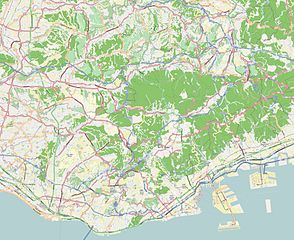
204:Attribution-ShareAlike 2.0 license (CC-BY-SA 2.0).
200:OpenStreetMap data and maps are licensed under the
1008:Université municipale d'infirmières de Kobe
440:https://creativecommons.org/licenses/by-sa/3.0
278:https://creativecommons.org/licenses/by-sa/2.0
93:
446:Creative Commons Attribution-Share Alike 3.0
370:
284:Creative Commons Attribution-Share Alike 2.0
208:
8:
406:– to copy, distribute and transmit the work
244:– to copy, distribute and transmit the work
597:
467:
147:project data, collected by the community.
845:The following other wikis use this file:
143:This map of Kobe, Japan was created from
913:Stade du Mémorial de l'Universiade
835:Module:Location map/data/Japan Kobe/doc
687:
571:
554:
538:
518:
502:
485:
482:
463:
456:
346:Georeference the map in Wikimaps Warper
883:Plantilla:Mapa de localización de Kobe
780:Nagata Station (Kobe Municipal Subway)
7:
393:Attribution-Share Alike 3.0 Unported
830:Module:Location map/data/Japan Kobe
675:User created page with UploadWizard
586:
381:
376:
231:Attribution-Share Alike 2.0 Generic
219:
214:
476:
470:
367:
205:
125:
71:
863:Şablon:Yer xəritəsi Yaponiya Kobe
475:
1013:Université préfectorale de Hyōgo
461:
417:Under the following conditions:
388:This file is licensed under the
380:
375:
369:
318:
255:Under the following conditions:
226:This file is licensed under the
218:
213:
207:
92:
31:
21:
745:Kyūkyoryūchi-Daimarumae Station
458:
14:
785:Sannomiya-Hanadokeimae Station
457:
26:
1:
344:
483:Items portrayed in this file
1128:Stazione di Mikage (Hankyū)
1123:Stazione di Okamoto (Hyōgo)
1078:Gare de Kasumigaoka (Hyōgo)
1018:Modèle:Géolocalisation/Kobe
873:Plantilya:Location map Kobe
869:Usage on ceb.wikipedia.org
760:Misaki-Kōen Station (Hyōgo)
1153:
1109:Usage on it.wikipedia.org
1099:Usage on id.wikipedia.org
889:Usage on fr.wikipedia.org
879:Usage on es.wikipedia.org
859:Usage on az.wikipedia.org
849:Usage on ar.wikipedia.org
431:same or compatible license
306:
269:same or compatible license
183:OpenStreetMap contributors
825:Ōkurayama Station (Hyōgo)
725:Kenchōmae Station (Hyōgo)
587:
329:
309:
297:
16:
1103:Templat:Peta lokasi Kobe
1063:Téléphérique Rokkō Arima
1028:Gare de Dōjō-minamiguchi
973:Terminal de fret de Kobe
750:Minato Motomachi Station
715:Kamisawa Station (Hyōgo)
460:
397:
235:
99:This is a file from the
993:Musée municipal de Kobe
958:Gare de Settsu-Motoyama
933:Shin Kobe Oriental City
775:Myōhōji Station (Hyōgo)
755:Minatogawa-kōen Station
674:
653:10:25, 24 December 2013
644:
623:10:42, 24 December 2013
338:
302:
188:
173:
163:
155:
135:
103:. Information from its
1083:Gare de Kobe-Sannomiya
1068:Téléphérique Shin-Kobe
1023:Gare de Shintetsu Dōjō
988:Mikage Residence Tower
853:قالب:Location map Kobe
810:Sōgō Undō Kōen Station
795:Seishin-minami Station
730:Kobe-Sannomiya Station
690:Chūō-Ichibamae Station
298: Geotemporal data
106:description page there
41:Size of this preview:
1118:Stazione di Sannomiya
740:Komagabayashi Station
963:Gare de Kōnan-Yamate
908:Stade du parc Misaki
790:Seishin-chūō Station
695:Gakuen-Toshi Station
65:2,210 × 1,806 pixels
61:1,253 × 1,024 pixels
1073:Gare de Nishi-Maiko
938:Kobe Portopia Hotel
923:Île du Port (Japon)
805:Shin-Nagata Station
412:– to adapt the work
250:– to adapt the work
47:Other resolutions:
1048:Gare de Maiko-Kōen
953:Gare de Rokkōmichi
903:Université de Kobe
820:Wadamisaki Station
700:Harborland Station
159:(see file history)
1137:more global usage
1053:Téléphérique Maya
968:Gare de Kanebōmae
841:Global file usage
800:Shin-Kōbe Station
705:Ikawadani Station
678:
541:copyright license
469:
357:
356:
353:
334:
333:
197:
194:Reusing this file
168:openstreetmap.org
150:
121:
120:
101:Wikimedia Commons
32:Global file usage
1144:
1113:Stazione di Kōbe
1088:Hôtel Okura Kobe
983:Taisan-ji (Kobe)
943:Minatogawa-jinja
815:Tanigami Station
665:
635:
505:copyright status
453:
450:
447:
444:
441:
433:as the original.
390:Creative Commons
384:
383:
379:
378:
373:
372:
351:
350:
348:
347:
322:
307:
291:
288:
285:
282:
279:
271:as the original.
228:Creative Commons
222:
221:
217:
216:
211:
210:
202:Creative Commons
191:
148:
139:
133:
117:
96:
95:
89:
83:
81:
68:
57:940 × 768 pixels
53:587 × 480 pixels
49:294 × 240 pixels
43:734 × 600 pixels
1152:
1151:
1147:
1146:
1145:
1143:
1142:
1141:
998:Mosquée de Kobe
918:Skymark Stadium
839:
770:Myōdani Station
765:Motomachi, Kobe
710:Itayado Station
686:
679:
671:
663:
641:
633:
589:
588:
585:
584:
583:
582:
581:
580:
579:
578:
576:
565:
564:
563:
562:
561:
559:
547:
546:
545:
543:
532:
531:
530:
529:
528:
527:
526:
525:
523:
511:
510:
509:
507:
496:
495:
494:
493:
492:
490:
474:
473:
472:
455:
454:
451:
448:
445:
442:
439:
438:
396:
385:
366:
358:
345:
342:
293:
292:
289:
286:
283:
280:
277:
276:
234:
223:
184:
182:
151:
137:
130:
123:
122:
111:
110:
109:is shown below.
85:
79:
77:
70:
69:
46:
12:
11:
5:
1150:
1148:
1139:of this file.
1133:
1132:
1131:
1130:
1125:
1120:
1115:
1107:
1106:
1105:
1097:
1096:
1095:
1090:
1085:
1080:
1075:
1070:
1065:
1060:
1055:
1050:
1045:
1040:
1035:
1030:
1025:
1020:
1015:
1010:
1005:
1000:
995:
990:
985:
980:
975:
970:
965:
960:
955:
950:
945:
940:
935:
930:
928:Kobe City Hall
925:
920:
915:
910:
905:
900:
895:
887:
886:
885:
877:
876:
875:
867:
866:
865:
857:
856:
855:
843:
842:
838:
837:
832:
827:
822:
817:
812:
807:
802:
797:
792:
787:
782:
777:
772:
767:
762:
757:
752:
747:
742:
737:
732:
727:
722:
720:Karumo Station
717:
712:
707:
702:
697:
692:
684:
683:
682:
677:
676:
673:
669:
666:
662:2,349 × 1,696
660:
655:
650:
647:
646:
643:
639:
636:
632:2,210 × 1,806
630:
625:
620:
616:
615:
612:
609:
606:
603:
600:
593:
592:
577:
572:
570:
569:
568:
567:
566:
560:
555:
553:
552:
551:
550:
549:
548:
544:
539:
537:
536:
535:
534:
533:
524:
519:
517:
516:
515:
514:
513:
512:
508:
503:
501:
500:
499:
498:
497:
491:
486:
484:
481:
480:
479:
478:
477:
466:
465:
462:
459:
437:
436:
435:
434:
424:
415:
414:
413:
407:
400:You are free:
387:
386:
368:
365:
362:
355:
354:
340:
339:Georeferencing
336:
335:
332:
331:
327:
326:
323:
316:
312:
311:
304:
300:
299:
295:
294:
275:
274:
273:
272:
262:
253:
252:
251:
245:
238:You are free:
225:
224:
206:
198:
186:
185:
178:
177:
175:
171:
170:
165:
161:
160:
157:
153:
152:
142:
140:
131:
129:
126:
124:
119:
118:
97:
87:
86:
40:
36:
35:
34:
29:
24:
19:
13:
10:
9:
6:
4:
3:
2:
1149:
1140:
1138:
1129:
1126:
1124:
1121:
1119:
1116:
1114:
1111:
1110:
1108:
1104:
1101:
1100:
1098:
1094:
1091:
1089:
1086:
1084:
1081:
1079:
1076:
1074:
1071:
1069:
1066:
1064:
1061:
1059:
1056:
1054:
1051:
1049:
1046:
1044:
1043:Gare de Gosha
1041:
1039:
1038:Gare de Taoji
1036:
1034:
1031:
1029:
1026:
1024:
1021:
1019:
1016:
1014:
1011:
1009:
1006:
1004:
1001:
999:
996:
994:
991:
989:
986:
984:
981:
979:
976:
974:
971:
969:
966:
964:
961:
959:
956:
954:
951:
949:
946:
944:
941:
939:
936:
934:
931:
929:
926:
924:
921:
919:
916:
914:
911:
909:
906:
904:
901:
899:
896:
894:
891:
890:
888:
884:
881:
880:
878:
874:
871:
870:
868:
864:
861:
860:
858:
854:
851:
850:
848:
847:
846:
840:
836:
833:
831:
828:
826:
823:
821:
818:
816:
813:
811:
808:
806:
803:
801:
798:
796:
793:
791:
788:
786:
783:
781:
778:
776:
773:
771:
768:
766:
763:
761:
758:
756:
753:
751:
748:
746:
743:
741:
738:
736:
733:
731:
728:
726:
723:
721:
718:
716:
713:
711:
708:
706:
703:
701:
698:
696:
693:
691:
688:
680:
672:
670:XIIIfromTOKYO
667:
661:
659:
656:
654:
651:
649:
648:
642:
640:XIIIfromTOKYO
637:
631:
629:
626:
624:
621:
618:
617:
613:
610:
607:
604:
601:
599:
598:
596:
590:
575:
558:
542:
522:
506:
489:
443:CC BY-SA 3.0
432:
428:
425:
422:
419:
418:
416:
411:
408:
405:
402:
401:
399:
398:
394:
391:
374:
363:
361:
360:
349:
341:
337:
328:
325:E: 135.3138°E
324:
321:
317:
314:
313:
308:
305:
301:
296:
281:CC BY-SA 2.0
270:
266:
263:
260:
257:
256:
254:
249:
246:
243:
240:
239:
237:
236:
232:
229:
212:
203:
199:
195:
190:
187:
181:
180:XIIIfromTOKYO
176:
172:
169:
166:
162:
158:
154:
146:
145:OpenStreetMap
141:
134:
127:
115:
108:
107:
102:
98:
91:
90:
84:
75:
74:Original file
66:
62:
58:
54:
50:
44:
39:
33:
30:
28:
25:
23:
20:
18:
15:
1134:
1093:Gare de Maya
1033:Gare de Nirō
978:Port de Kobe
948:Gare de Nada
898:Île de Rokkō
844:
735:Kobe Airport
645:wrong geoloc
594:
591:File history
426:
420:
409:
403:
359:
330:S: 34.6202°N
315:W: 134.907°E
303:Bounding box
264:
258:
247:
241:
138:Map Kobe.jpg
114:You can help
104:
72:
22:File history
893:Ikuta-jinja
521:copyrighted
427:share alike
421:attribution
310:N: 34.893°N
265:share alike
259:attribution
136:Description
1058:Kikuseidai
681:File usage
608:Dimensions
189:Permission
80:image/jpeg
27:File usage
664:(1.19 MB)
634:(1.19 MB)
605:Thumbnail
602:Date/Time
364:Licensing
464:Captions
410:to remix
404:to share
395:license.
248:to remix
242:to share
233:license.
619:current
614:Comment
488:depicts
468:English
174:Creator
128:Summary
76:
164:Source
1135:View
611:User
452:true
449:true
290:true
287:true
156:Date
17:File
63:|
59:|
55:|
51:|
45:.
196:)
192:(
116:.
82:)
67:.
Text is available under the Creative Commons Attribution-ShareAlike License. Additional terms may apply.
