271:
225:
277:
43:
282:
91:
608:
323:– You must give appropriate credit, provide a link to the license, and indicate if changes were made. You may do so in any reasonable manner, but not in any way that suggests the licensor endorses you or your use.
57:
53:
47:
244:
The ODbL does not require any particular license for maps produced from ODbL data. Prior to 1 August 2020, map tiles produced by the OpenStreetMap
Foundation were licensed under the
70:
102:
440:
201:
553:
517:
680:
This file contains additional information, probably added from the digital camera or scanner used to create or digitize it.
330:
501:
607:
602:
61:
42:
537:
484:
143:
639:
186:
436:
292:
683:
If the file has been modified from its original state, some details may not fully reflect the modified file.
635:
The following pages on the
English Knowledge (XXG) use this file (pages on other projects are not listed):
217:). Map tiles are licensed under the Creative Commons Attribution-ShareAlike 2.0 license (CC-BY-SA 2.0).
329:– If you remix, transform, or build upon the material, you must distribute your contributions under the
432:
289:
110:
219:
155:
This map may be incomplete, and may contain errors. Don't rely solely on it for navigation.
97:
364:
245:
237:
150:
210:
396:
214:
618:
224:
129:
575:
Click on a date/time to view the file as it appeared at that time.
248:. Maps produced by other people may be subject to other licences.
233:
173:
85:
625:
Transferred from en.wikipedia: see original upload log above
657:
468:
Add a one-line explanation of what this file represents
447:(Uploading a file from a free published source using ])
403:
373:
If inappropriate please set warp_status = skip to hide.
667:
185:
OpenStreetMap contributors (Boundary lines added by:
109:
Commons is a freely licensed media file repository.
554:
Creative
Commons Attribution-ShareAlike 2.0 Generic
406:. All following user names refer to en.wikipedia.
135:Map of Beverly Grove, Los Angeles, California.png
75:(879 × 612 pixels, file size: 642 KB, MIME type:
391:
340:https://creativecommons.org/licenses/by-sa/2.0
90:
346:Creative Commons Attribution-Share Alike 2.0
270:
257:http://opendatacommons.org/licenses/odbl/1.0/
8:
306:– to copy, distribute and transmit the work
685:
577:
464:
209:OpenStreetMap data is available under the
153:project data, collected by the community.
650:The following other wikis use this file:
408:
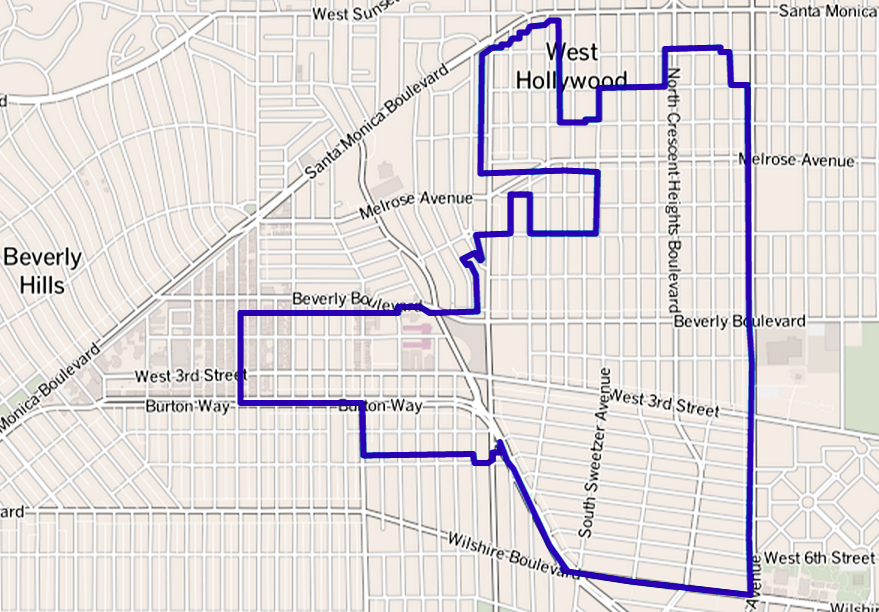
147:neighborhood in Los Angeles, California.
695:
687:
637:
551:
535:
515:
499:
482:
479:
460:
453:
367:Georeference the map in Wikimaps Warper
7:
236:, which is made available under the
232:This work contains information from
566:
293:Attribution-Share Alike 2.0 Generic
281:
276:
678:
473:
467:
402:The original description page was
401:
267:
122:
68:
472:
458:
317:Under the following conditions:
288:This file is licensed under the
280:
275:
269:
223:
89:
31:
21:
455:
14:
454:
26:
1:
365:
36:
480:Items portrayed in this file
238:Open Database License (ODbL)
222:
149:This map was created from
717:
664:Usage on www.wikidata.org
654:Usage on fr.wikipedia.org
640:Beverly Grove, Los Angeles
331:same or compatible license
191:OpenStreetMap contributors
567:
429:879 × 612 (656,960 bytes)
165:27 May 2013 (upload date)
16:
457:
297:
96:This is a file from the
624:
359:
196:
179:
169:
161:
132:
100:. Information from its
103:description page there
46:Size of this preview:
689:Horizontal resolution
251:Open Database License
211:Open Database License
187:The Los Angeles Times
246:CC-BY-SA-2.0 license
697:Vertical resolution
397:For the Common Good
385:Original upload log
312:– to adapt the work
52:Other resolutions:
603:22:05, 28 May 2013
426:05:29, 27 May 2013
704:
703:
646:Global file usage
628:
538:copyright license
466:
452:
451:
395:to Commons using
389:Transferred from
378:
377:
374:
266:
265:
249:
205:
202:Reusing this file
174:openstreetmap.org
156:
118:
117:
98:Wikimedia Commons
32:Global file usage
708:
686:
615:
502:copyright status
433:w:en:GeorgeLouis
409:
394:
372:
371:
369:
368:
353:
350:
347:
344:
341:
333:as the original.
290:Creative Commons
284:
283:
279:
278:
273:
272:
261:
258:
255:
252:
243:
227:
220:
199:
154:
136:
130:
114:
93:
92:
86:
80:
78:
65:
62:879 × 612 pixels
58:640 × 446 pixels
54:320 × 223 pixels
48:800 × 557 pixels
716:
715:
711:
710:
709:
707:
706:
705:
674:
644:
636:
629:
621:
613:
569:
568:
565:
564:
563:
562:
561:
560:
559:
558:
556:
544:
543:
542:
540:
529:
528:
527:
526:
525:
524:
523:
522:
520:
508:
507:
506:
504:
493:
492:
491:
490:
489:
487:
471:
470:
469:
407:
390:
387:
379:
366:
363:
355:
354:
351:
348:
345:
342:
339:
338:
296:
285:
259:
256:
253:
250:
192:
190:
157:
148:
134:
127:
120:
119:
108:
107:
106:is shown below.
82:
76:
74:
67:
66:
51:
12:
11:
5:
714:
712:
702:
701:
698:
694:
693:
690:
677:
673:
672:
671:
670:
662:
661:
660:
648:
647:
643:
642:
634:
633:
632:
627:
626:
623:
619:
616:
610:
605:
600:
596:
595:
592:
589:
586:
583:
580:
573:
572:
557:
552:
550:
549:
548:
547:
546:
545:
541:
536:
534:
533:
532:
531:
530:
521:
516:
514:
513:
512:
511:
510:
509:
505:
500:
498:
497:
496:
495:
494:
488:
483:
481:
478:
477:
476:
475:
474:
463:
462:
459:
456:
450:
449:
444:
430:
427:
423:
422:
419:
416:
413:
386:
383:
376:
375:
361:
360:Georeferencing
357:
356:
337:
336:
335:
334:
324:
315:
314:
313:
307:
300:You are free:
287:
286:
268:
264:
263:
230:
228:
206:
194:
193:
184:
183:
181:
177:
176:
171:
167:
166:
163:
159:
158:
140:
139:
137:
128:
126:
123:
121:
116:
115:
94:
84:
83:
45:
41:
40:
39:
34:
29:
24:
19:
13:
10:
9:
6:
4:
3:
2:
713:
699:
696:
691:
688:
684:
681:
675:
669:
666:
665:
663:
659:
658:Beverly Grove
656:
655:
653:
652:
651:
645:
641:
638:
630:
622:
617:
611:
609:
606:
604:
601:
598:
597:
593:
590:
587:
584:
581:
579:
578:
576:
570:
555:
539:
519:
503:
486:
448:
445:
442:
438:
434:
431:
428:
425:
424:
420:
417:
414:
411:
410:
405:
400:
398:
393:
384:
382:
381:
370:
362:
358:
343:CC BY-SA 2.0
332:
328:
325:
322:
319:
318:
316:
311:
308:
305:
302:
301:
299:
298:
294:
291:
274:
262:
247:
241:
239:
235:
234:OpenStreetMap
231:
229:
226:
221:
218:
216:
212:
207:
203:
198:
195:
188:
182:
178:
175:
172:
168:
164:
160:
152:
151:OpenStreetMap
146:
145:
144:Beverly Grove
138:
131:
124:
112:
105:
104:
99:
95:
88:
87:
81:
72:
71:Original file
63:
59:
55:
49:
44:
38:
35:
33:
30:
28:
25:
23:
20:
18:
15:
682:
679:
649:
574:
571:File history
446:
392:en.wikipedia
388:
380:
326:
320:
309:
303:
242:
208:
142:
111:You can help
101:
69:
22:File history
518:copyrighted
327:share alike
321:attribution
141:Map of the
133:Description
631:File usage
612:879 × 612
588:Dimensions
415:Dimensions
197:Permission
27:File usage
700:28.35 dpc
692:28.35 dpc
668:Q16254518
585:Thumbnail
582:Date/Time
412:Date/Time
77:image/png
676:Metadata
614:(642 KB)
461:Captions
441:contribs
421:Comment
310:to remix
304:to share
295:license.
37:Metadata
599:current
594:Comment
485:depicts
465:English
215:details
180:Creator
125:Summary
73:
170:Source
591:User
437:talk
418:User
404:here
352:true
349:true
260:true
254:ODbL
162:Date
17:File
620:ALH
439:|
399:.
240:.
60:|
56:|
50:.
443:)
435:(
213:(
204:)
200:(
189:)
113:.
79:)
64:.
Text is available under the Creative Commons Attribution-ShareAlike License. Additional terms may apply.