43:
287:
293:
298:
252:
233:
99:
212:
681:
223:
339:– You must give appropriate credit, provide a link to the license, and indicate if changes were made. You may do so in any reasonable manner, but not in any way that suggests the licensor endorses you or your use.
73:
69:
65:
61:
57:
53:
47:
82:
110:
195:
626:
556:
520:
743:
This file contains additional information, probably added from the digital camera or scanner used to create or digitize it.
346:
610:
504:
476:
461:
448:
576:
540:
421:
404:
483:
680:
675:
42:
712:
308:
746:
If the file has been modified from its original state, some details may not fully reflect the modified file.
345:– If you remix, transform, or build upon the material, you must distribute your contributions under the
305:
708:
The following pages on the
English Knowledge use this file (pages on other projects are not listed):
118:
468:
691:
176:
162:
105:
280:
I, the copyright holder of this work, hereby publish it under the following license:
243:
180:
259:
218:
648:
Click on a date/time to view the file as it appeared at that time.
251:
232:
239:
184:
93:
211:
87:(SVG file, nominally 1,449 × 859 pixels, file size: 1.46 MB)
388:
Add a one-line explanation of what this file represents
730:
153:
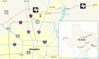
Map of FM 1960 in Harris and
Liberty Counties, Texas.
557:
Creative
Commons Attribution-ShareAlike 3.0 Unported
137:
117:
Commons is a freely licensed media file repository.
356:https://creativecommons.org/licenses/by-sa/3.0
98:
469:https://commons.wikimedia.org/user:Kenny_G_TX
362:Creative Commons Attribution-Share Alike 3.0
286:
143:Map of Farm to Market Road 1960 (FM 1960).svg
8:
322:– to copy, distribute and transmit the work
46:Size of this PNG preview of this SVG file:
748:
650:
384:
185:Texas Natural Resources Information System
723:The following other wikis use this file:
766:
758:
750:
710:
624:
608:
590:
574:
554:
538:
518:
502:
435:
419:
402:
399:
380:
373:
7:
309:Attribution-Share Alike 3.0 Unported
698:User created page with UploadWizard
639:
297:
292:
741:
393:
387:
283:
279:
256:
237:
216:
147:
130:
80:
392:
181:National Highway Planning Network
378:
333:Under the following conditions:
304:This file is licensed under the
296:
291:
285:
250:
231:
210:
97:
31:
21:
375:
148:
14:
374:
26:
1:
627:original creation by uploader
175:using GIS data obtained from
36:
400:Items portrayed in this file
788:
727:Usage on www.wikidata.org
347:same or compatible license
163:18 February 2014, 15:57:48
640:
172:
16:
713:Farm to Market Road 1960
377:
313:
104:This is a file from the
697:
676:22:01, 18 February 2014
191:
168:
161:
158:
140:
108:. Information from its
111:description page there
202:SVG development
70:2,560 × 1,518 pixels
328:– to adapt the work
52:Other resolutions:
477:Wikimedia username
449:author name string
177:U.S. Census Bureau
74:1,449 × 859 pixels
66:1,280 × 759 pixels
62:1,024 × 607 pixels
775:
774:
755:Generated with Qt
719:Global file usage
701:
541:copyright license
386:
270:
269:
242:was created with
126:
125:
106:Wikimedia Commons
32:Global file usage
779:
749:
688:
592:18 February 2014
505:copyright status
486:
481:
471:
466:
456:
453:
369:
366:
363:
360:
357:
349:as the original.
306:Creative Commons
300:
299:
295:
294:
289:
288:
262:
254:
235:
226:
214:
174:
164:
152:
144:
138:
122:
101:
100:
94:
88:
77:
58:640 × 379 pixels
54:320 × 190 pixels
48:800 × 474 pixels
787:
786:
782:
781:
780:
778:
777:
776:
737:
717:
709:
702:
694:
686:
642:
641:
638:
637:
636:
635:
634:
633:
632:
631:
629:
617:
616:
615:
613:
602:
601:
600:
599:
598:
597:
596:
595:
593:
583:
582:
581:
579:
568:
567:
566:
565:
564:
563:
562:
561:
559:
547:
546:
545:
543:
532:
531:
530:
529:
528:
527:
526:
525:
523:
511:
510:
509:
507:
496:
495:
494:
493:
492:
491:
490:
489:
488:
487:
482:
479:
473:
472:
467:
464:
458:
457:
454:
451:
442:
441:
440:
438:
428:
427:
426:
424:
413:
412:
411:
410:
409:
407:
391:
390:
389:
372:
371:
370:
367:
364:
361:
358:
355:
354:
312:
301:
282:
281:
276:
271:
266:
265:
264:
258:
248:
247:
229:
228:
222:
205:
154:
142:
135:
128:
127:
116:
115:
114:is shown below.
90:
86:
79:
78:
51:
12:
11:
5:
785:
783:
773:
772:
769:
765:
764:
761:
757:
756:
753:
740:
736:
735:
734:
733:
721:
720:
716:
715:
707:
706:
705:
700:
699:
696:
692:
689:
683:
678:
673:
669:
668:
665:
662:
659:
656:
653:
646:
645:
630:
625:
623:
622:
621:
620:
619:
618:
614:
611:source of file
609:
607:
606:
605:
604:
603:
594:
591:
589:
588:
587:
586:
585:
584:
580:
575:
573:
572:
571:
570:
569:
560:
555:
553:
552:
551:
550:
549:
548:
544:
539:
537:
536:
535:
534:
533:
524:
519:
517:
516:
515:
514:
513:
512:
508:
503:
501:
500:
499:
498:
497:
475:
474:
460:
459:
447:
446:
445:
444:
443:
439:
436:
434:
433:
432:
431:
430:
429:
425:
420:
418:
417:
416:
415:
414:
408:
403:
401:
398:
397:
396:
395:
394:
383:
382:
379:
376:
353:
352:
351:
350:
340:
331:
330:
329:
323:
316:You are free:
303:
302:
284:
278:
277:
275:
272:
268:
267:
249:
230:
209:
208:
206:
203:
199:
198:
193:
189:
188:
170:
166:
165:
160:
156:
155:
145:
136:
134:
131:
129:
124:
123:
102:
92:
91:
45:
41:
40:
39:
34:
29:
24:
19:
13:
10:
9:
6:
4:
3:
2:
784:
770:
767:
762:
759:
754:
751:
747:
744:
738:
732:
729:
728:
726:
725:
724:
718:
714:
711:
703:
695:
690:
684:
682:
679:
677:
674:
671:
670:
666:
663:
660:
657:
654:
652:
651:
649:
643:
628:
612:
578:
558:
542:
522:
506:
485:
478:
470:
463:
450:
423:
406:
359:CC BY-SA 3.0
348:
344:
341:
338:
335:
334:
332:
327:
324:
321:
318:
317:
315:
314:
310:
307:
290:
273:
261:
253:
245:
241:
234:
225:
220:
213:
207:
201:
200:
197:
194:
190:
186:
182:
178:
171:
167:
157:
151:
146:
139:
132:
120:
113:
112:
107:
103:
96:
95:
89:
84:
83:Original file
75:
71:
67:
63:
59:
55:
49:
44:
38:
35:
33:
30:
28:
25:
23:
20:
18:
15:
745:
742:
722:
685:1,449 × 859
647:
644:File history
342:
336:
325:
319:
149:
119:You can help
109:
81:
22:File history
752:Image title
521:copyrighted
343:share alike
337:attribution
141:Description
704:File usage
693:Kenny G TX
661:Dimensions
484:Kenny G TX
455:Kenny G TX
437:some value
196:Kenny G TX
27:File usage
771:859.27814
763:1449.2782
687:(1.46 MB)
658:Thumbnail
655:Date/Time
577:inception
274:Licensing
257:and with
204:InfoField
150:English:
739:Metadata
731:Q2505175
381:Captions
326:to remix
320:to share
311:license.
244:Inkscape
221:code is
173:Own work
37:Metadata
672:current
667:Comment
422:creator
405:depicts
385:English
133:Summary
85:
768:Height
255:
238:This
236:
215:
192:Author
169:Source
760:Width
224:valid
664:User
368:true
365:true
260:QGIS
217:The
183:and
159:Date
17:File
462:URL
240:map
219:SVG
480::
465::
452::
179:,
72:|
68:|
64:|
60:|
56:|
50:.
263:.
246:.
227:.
187:.
121:.
76:.
Text is available under the Creative Commons Attribution-ShareAlike License. Additional terms may apply.

.svg)