43:
249:
213:
255:
260:
99:
673:
643:
301:– You must give appropriate credit, provide a link to the license, and indicate if changes were made. You may do so in any reasonable manner, but not in any way that suggests the licensor endorses you or your use.
73:
69:
65:
61:
57:
53:
47:
110:
82:
554:
518:
785:
This file contains additional information, probably added from the digital camera or scanner used to create or digitize it.
399:
382:
308:
672:
667:
502:
474:
461:
446:
574:
538:
419:
366:
481:
270:
788:
If the file has been modified from its original state, some details may not fully reflect the modified file.
700:
The following pages on the
English Knowledge (XXG) use this file (pages on other projects are not listed):
307:– If you remix, transform, or build upon the material, you must distribute your contributions under the
267:
118:
642:
637:
42:
714:
453:
704:
158:
201:
105:
242:
I, the copyright holder of this work, hereby publish it under the following license:
683:
653:
350:
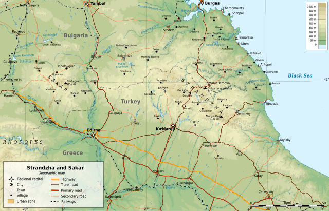
Geographic map of
Strandzha and Sakar mountains in Bulgaria and Turkey (in English)
154:
212:
226:
709:
610:
Click on a date/time to view the file as it appeared at that time.
211:
742:
93:
87:(SVG file, nominally 1,596 × 1,024 pixels, file size: 6.28 MB)
752:
772:
762:
555:
Creative
Commons Attribution-ShareAlike 3.0 Unported
137:
117:
Commons is a freely licensed media file repository.
732:
161:maountains in Bulgaria and Turkey (in English)
318:https://creativecommons.org/licenses/by-sa/3.0
98:
324:Creative Commons Attribution-Share Alike 3.0
248:
8:
284:– to copy, distribute and transmit the work
46:Size of this PNG preview of this SVG file:
790:
612:
454:https://commons.wikimedia.org/user:Ikonact
346:
725:The following other wikis use this file:
190:Transport, Rivers, Places: OpenStreetMap
800:
792:
702:
588:
572:
552:
536:
516:
500:
433:
417:
397:
380:
364:
361:
342:
335:
7:
271:Attribution-Share Alike 3.0 Unported
690:User created page with UploadWizard
601:
259:
254:
783:
355:
349:
245:
241:
147:
130:
80:
354:
340:
295:Under the following conditions:
266:This file is licensed under the
258:
253:
247:
97:
31:
21:
337:
148:
14:
336:
166:Geographic limits of the map:
26:
1:
216:Map of Strandzha Sakar bg.svg
143:Map of Strandzha Sakar en.svg
36:
362:Items portrayed in this file
163:UTM projection, WGS84 datum
660:correction of cyrillic text
822:
769:Usage on ro.wikipedia.org
759:Usage on pt.wikipedia.org
749:Usage on it.wikipedia.org
739:Usage on fr.wikipedia.org
729:Usage on cs.wikipedia.org
309:same or compatible license
602:
16:
339:
275:
104:This is a file from the
689:
659:
222:
207:
202:12 March 2013, 00:58:44
200:
197:
187:Topography: NASA SRTM3;
140:
108:. Information from its
217:
111:description page there
215:
668:00:01, 12 March 2013
638:00:10, 12 March 2013
74:1,596 × 1,024 pixels
70:2,560 × 1,643 pixels
290:– to adapt the work
52:Other resolutions:
475:Wikimedia username
462:author name string
218:
153:Geographic map of
66:1,280 × 821 pixels
62:1,024 × 657 pixels
809:
808:
743:Strandja (massif)
721:Global file usage
715:Strandzha Commune
693:
539:copyright license
348:
232:
231:
183:Sources of data:
126:
125:
106:Wikimedia Commons
32:Global file usage
813:
791:
705:Sakar (mountain)
680:
650:
503:copyright status
484:
479:
469:
466:
456:
451:
331:
328:
325:
322:
319:
311:as the original.
268:Creative Commons
262:
261:
257:
256:
251:
250:
203:
152:
144:
138:
122:
101:
100:
94:
88:
77:
58:640 × 411 pixels
54:320 × 205 pixels
48:800 × 513 pixels
821:
820:
816:
815:
814:
812:
811:
810:
779:
719:
701:
694:
686:
678:
656:
648:
604:
603:
600:
599:
598:
597:
596:
595:
594:
593:
591:
581:
580:
579:
577:
566:
565:
564:
563:
562:
561:
560:
559:
557:
545:
544:
543:
541:
530:
529:
528:
527:
526:
525:
524:
523:
521:
509:
508:
507:
505:
494:
493:
492:
491:
490:
489:
488:
487:
486:
485:
480:
477:
471:
470:
467:
464:
458:
457:
452:
449:
440:
439:
438:
436:
426:
425:
424:
422:
411:
410:
409:
408:
407:
406:
405:
404:
402:
391:
390:
389:
388:
387:
385:
373:
372:
371:
369:
353:
352:
351:
334:
333:
332:
329:
326:
323:
320:
317:
316:
274:
263:
244:
243:
238:
233:
193:
142:
135:
128:
127:
116:
115:
114:is shown below.
90:
86:
79:
78:
51:
12:
11:
5:
819:
817:
807:
806:
803:
799:
798:
795:
782:
778:
777:
776:
775:
767:
766:
765:
757:
756:
755:
747:
746:
745:
737:
736:
735:
723:
722:
718:
717:
712:
707:
699:
698:
697:
692:
691:
688:
684:
681:
677:1,596 × 1,024
675:
670:
665:
662:
661:
658:
654:
651:
647:1,596 × 1,024
645:
640:
635:
631:
630:
627:
624:
621:
618:
615:
608:
607:
592:
589:
587:
586:
585:
584:
583:
582:
578:
573:
571:
570:
569:
568:
567:
558:
553:
551:
550:
549:
548:
547:
546:
542:
537:
535:
534:
533:
532:
531:
522:
517:
515:
514:
513:
512:
511:
510:
506:
501:
499:
498:
497:
496:
495:
473:
472:
460:
459:
445:
444:
443:
442:
441:
437:
434:
432:
431:
430:
429:
428:
427:
423:
418:
416:
415:
414:
413:
412:
403:
400:Sakar Mountain
398:
396:
395:
394:
393:
392:
386:
381:
379:
378:
377:
376:
375:
374:
370:
365:
363:
360:
359:
358:
357:
356:
345:
344:
341:
338:
315:
314:
313:
312:
302:
293:
292:
291:
285:
278:You are free:
265:
264:
246:
240:
239:
237:
234:
230:
229:
224:
220:
219:
209:
205:
204:
199:
195:
194:
192:
191:
188:
181:
180:
179:South: 42.5° N
177:
176:North: 41.2° N
174:
171:
145:
136:
134:
131:
129:
124:
123:
102:
92:
91:
45:
41:
40:
39:
34:
29:
24:
19:
13:
10:
9:
6:
4:
3:
2:
818:
804:
801:
796:
793:
789:
786:
780:
774:
771:
770:
768:
764:
761:
760:
758:
754:
751:
750:
748:
744:
741:
740:
738:
734:
731:
730:
728:
727:
726:
720:
716:
713:
711:
708:
706:
703:
695:
687:
682:
676:
674:
671:
669:
666:
664:
663:
657:
652:
646:
644:
641:
639:
636:
633:
632:
628:
625:
622:
619:
616:
614:
613:
611:
605:
590:12 March 2013
576:
556:
540:
520:
504:
483:
476:
463:
455:
448:
421:
401:
384:
368:
321:CC BY-SA 3.0
310:
306:
303:
300:
297:
296:
294:
289:
286:
283:
280:
279:
277:
276:
272:
269:
252:
235:
228:
225:
221:
214:
210:
206:
196:
189:
186:
185:
184:
178:
175:
173:East: 28.5° E
172:
170:West: 25.8° E
169:
168:
167:
164:
160:
156:
151:
146:
139:
132:
120:
113:
112:
107:
103:
96:
95:
89:
84:
83:Original file
75:
71:
67:
63:
59:
55:
49:
44:
38:
35:
33:
30:
28:
25:
23:
20:
18:
15:
787:
784:
724:
609:
606:File history
304:
298:
287:
281:
182:
165:
162:
149:
119:You can help
109:
81:
22:File history
519:copyrighted
305:share alike
299:attribution
141:Description
696:File usage
623:Dimensions
435:some value
27:File usage
710:Strandzha
679:(6.28 MB)
649:(6.28 MB)
620:Thumbnail
617:Date/Time
575:inception
383:Strandzha
236:Licensing
155:Strandzha
150:English:
781:Metadata
773:Strandja
763:Istranca
753:Strandža
343:Captions
288:to remix
282:to share
273:license.
37:Metadata
685:Ikonact
655:Ikonact
634:current
629:Comment
482:Ikonact
468:Ikonact
420:creator
367:depicts
347:English
227:Ikonact
133:Summary
85:
802:Height
223:Author
208:Source
794:Width
733:Sakar
159:Sakar
805:1024
797:1596
626:User
330:true
327:true
198:Date
157:and
17:File
447:URL
478::
465::
450::
72:|
68:|
64:|
60:|
56:|
50:.
121:.
76:.
Text is available under the Creative Commons Attribution-ShareAlike License. Additional terms may apply.

