38:
258:
223:
86:
243:
UN maps are, in principle, open source material and you can use them in your work or for making your own map. UN requests however that you delete the UN name, logo and reference number upon any modification to the map. Content of your map will be your responsibility. You can state in your
384:
488:
52:
48:
42:
97:
65:
498:
401:{{Information |Description ={{en|1=d}} |Source =d |Author =d |Date =d |Permission = |other_versions = }} d
448:
179:
245:
508:
315:
298:
244:
publication, if you wish, something like: based on UN map … (map name, map number, revision number and date). See:
160:
411:
The following pages on the
English Knowledge (XXG) use this file (pages on other projects are not listed):
383:
378:
56:
37:
415:
237:
Unless stated otherwise, UN maps are to be considered in the public domain. This applies worldwide.
105:
186:
The original file is marked with the UN symbol which means that it is a public domain resource.
420:
394:
92:
230:
249:
257:
149:
240:
Some UN maps have special copyrights, as indicated on the map itself.
478:
351:
Click on a date/time to view the file as it appeared at that time.
458:
468:
438:
217:
80:
256:
282:
Add a one-line explanation of what this file represents
70:(1,017 × 1,659 pixels, file size: 1.02 MB, MIME type:
518:
124:
104:
Commons is a freely licensed media file repository.
170:UNOSAT, United Nations, modified by Dr. Blofeld
85:
8:
250:Geospatial, location data for a better world
353:
278:
197:
431:The following other wikis use this file:
413:
329:
313:
296:
293:
274:
267:
222:
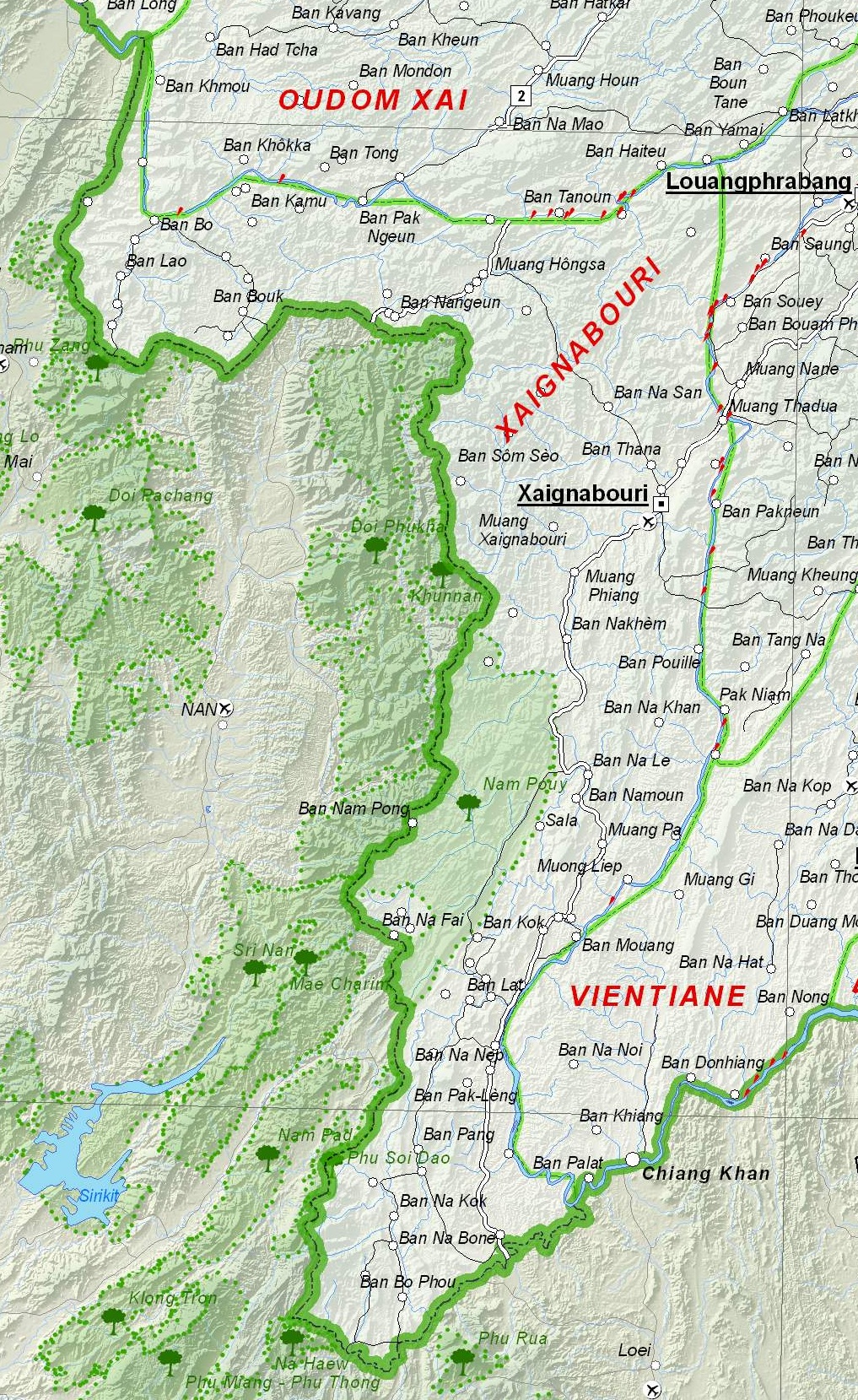
130:Map of Xaignabouri Province, Laos.jpg
7:
342:
228:This image is a map derived from a
287:
281:
140:Map of Xaignabouri Province, Laos.
134:
117:
63:
286:
272:
221:
84:
31:
21:
269:
135:
14:
268:
246:Geospatial Information Section
26:
1:
161:File:UNOSAT Laos Base Map.jpg
294:Items portrayed in this file
537:
515:Usage on vi.wikipedia.org
505:Usage on ur.wikipedia.org
495:Usage on th.wikipedia.org
485:Usage on ml.wikipedia.org
475:Usage on it.wikipedia.org
465:Usage on id.wikipedia.org
455:Usage on fr.wikipedia.org
445:Usage on fa.wikipedia.org
435:Usage on de.wikipedia.org
343:
16:
479:Provincia di Xaignabouli
271:
91:This is a file from the
400:
174:
166:
155:
148:
145:
127:
95:. Information from its
379:21:09, 6 December 2012
261:
98:description page there
41:Size of this preview:
459:Province de Sayaboury
260:
469:Provinsi Xaignabouli
57:1,017 × 1,659 pixels
489:സൈന്യാബുലി പ്രവിശ്യ
416:Sainyabuli province
47:Other resolutions:
439:Provinz Sainyabuli
262:
427:Global file usage
404:
280:
266:
265:
216:
215:
190:
189:
183:
180:Reusing this file
113:
112:
93:Wikimedia Commons
32:Global file usage
528:
449:استان ساینیابولی
421:The Chinese Road
391:
225:
224:
218:
212:
209:
206:
203:
198:
177:
151:
139:
131:
125:
109:
88:
87:
81:
75:
73:
60:
53:294 × 480 pixels
49:147 × 240 pixels
43:367 × 599 pixels
536:
535:
531:
530:
529:
527:
526:
525:
509:سائنیابولی صوبہ
425:
412:
405:
397:
389:
345:
344:
341:
340:
339:
338:
337:
336:
335:
334:
332:
331:6 December 2012
322:
321:
320:
318:
307:
306:
305:
304:
303:
301:
285:
284:
283:
210:
207:
204:
201:
196:
191:
150:6 December 2012
141:
129:
122:
115:
114:
103:
102:
101:is shown below.
77:
71:
69:
62:
61:
46:
12:
11:
5:
534:
532:
524:
523:
522:
521:
513:
512:
511:
503:
502:
501:
493:
492:
491:
483:
482:
481:
473:
472:
471:
463:
462:
461:
453:
452:
451:
443:
442:
441:
429:
428:
424:
423:
418:
410:
409:
408:
403:
402:
399:
395:
392:
388:1,017 × 1,659
386:
381:
376:
372:
371:
368:
365:
362:
359:
356:
349:
348:
333:
330:
328:
327:
326:
325:
324:
323:
319:
314:
312:
311:
310:
309:
308:
302:
297:
295:
292:
291:
290:
289:
288:
277:
276:
273:
270:
264:
263:
254:
231:United Nations
226:
214:
213:
195:
192:
188:
187:
184:
172:
171:
168:
164:
163:
157:
153:
152:
147:
143:
142:
132:
123:
121:
118:
116:
111:
110:
89:
79:
78:
40:
36:
35:
34:
29:
24:
19:
13:
10:
9:
6:
4:
3:
2:
533:
520:
517:
516:
514:
510:
507:
506:
504:
500:
497:
496:
494:
490:
487:
486:
484:
480:
477:
476:
474:
470:
467:
466:
464:
460:
457:
456:
454:
450:
447:
446:
444:
440:
437:
436:
434:
433:
432:
426:
422:
419:
417:
414:
406:
398:
393:
387:
385:
382:
380:
377:
374:
373:
369:
366:
363:
360:
357:
355:
354:
352:
346:
317:
300:
259:
255:
253:
251:
247:
241:
239:
238:
233:
232:
227:
220:
219:
205:Public domain
202:Public domain
200:
199:
193:
185:
181:
176:
173:
169:
165:
162:
158:
154:
144:
138:
133:
126:
119:
107:
100:
99:
94:
90:
83:
82:
76:
67:
66:Original file
58:
54:
50:
44:
39:
33:
30:
28:
25:
23:
20:
18:
15:
430:
350:
347:File history
242:
236:
235:
229:
136:
106:You can help
96:
64:
22:File history
499:แขวงไชยบุรี
396:Blofeld Dr.
128:Description
407:File usage
364:Dimensions
175:Permission
72:image/jpeg
27:File usage
390:(1.02 MB)
361:Thumbnail
358:Date/Time
316:inception
194:Licensing
159:Based on
137:English:
519:Xayabury
275:Captions
375:current
370:Comment
299:depicts
279:English
248:. And:
120:Summary
68:
167:Author
156:Source
234:map.
211:false
208:false
367:User
146:Date
17:File
252:.
55:|
51:|
45:.
182:)
178:(
108:.
74:)
59:.
Text is available under the Creative Commons Attribution-ShareAlike License. Additional terms may apply.
