305:
43:
376:
477:
382:
387:
328:
286:
99:
265:
1626:
1095:
1245:
1215:
1185:
1631:
1155:
1125:
1356:
1065:
165:
1671:
1376:
438:– You must give appropriate credit, provide a link to the license, and indicate if changes were made. You may do so in any reasonable manner, but not in any way that suggests the licensor endorses you or your use.
1696:
276:
1556:
1546:
1298:
1586:
494:
1283:
73:
69:
65:
61:
57:
53:
47:
1346:
110:
82:
492:; with no Invariant Sections, no Front-Cover Texts, and no Back-Cover Texts. A copy of the license is included in the section entitled
484:
319:
898:
776:
740:
723:
687:
1481:
1293:
246:
241:
236:
231:
226:
1744:
This file contains additional information, probably added from the digital camera or scanner used to create or digitize it.
1606:
445:
1244:
1239:
1214:
1209:
1184:
1179:
1154:
1149:
1124:
1119:
1094:
1089:
1303:
1267:
993:
956:
919:
864:
830:
760:
671:
643:
628:
615:
489:
891:
796:
707:
588:
571:
1526:
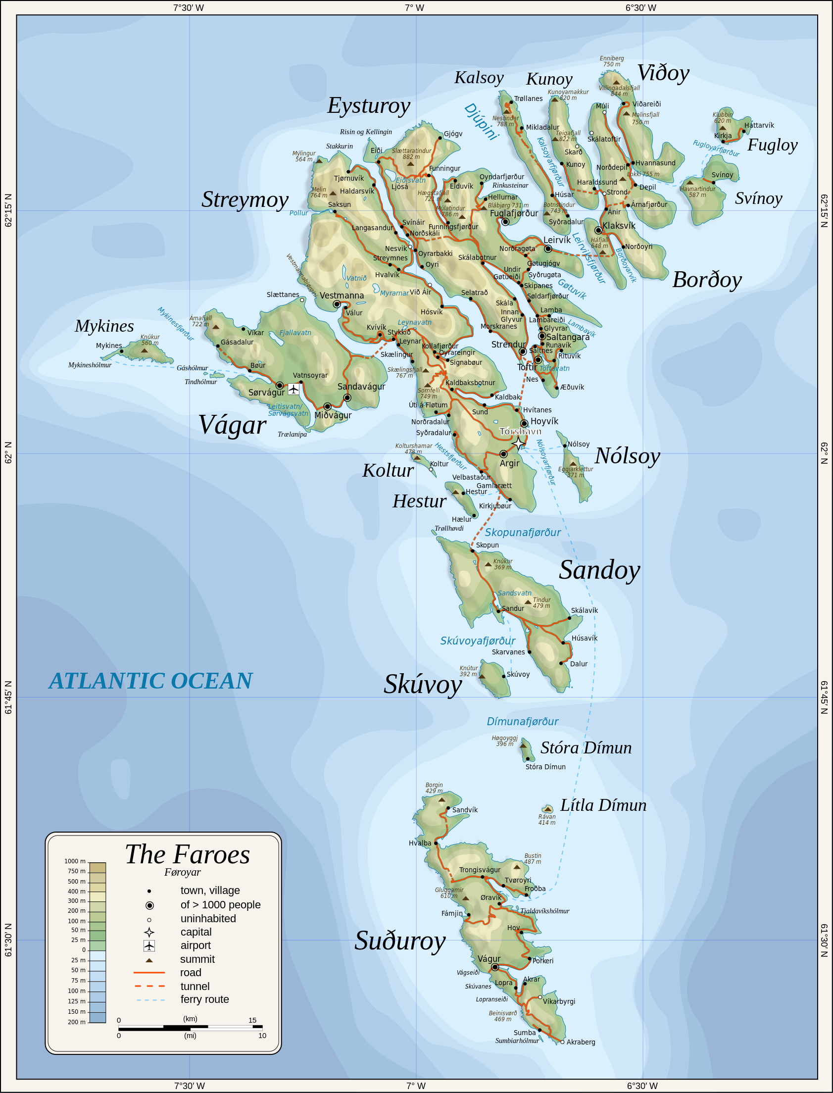
1262:{{Information |Description={{en|1=Topographic map of the Faroe Islands.}} |Source=Own work by uploader |Author=
397:
1747:
If the file has been modified from its original state, some details may not fully reflect the modified file.
635:
444:– If you remix, transform, or build upon the material, you must distribute your contributions under the
1318:
394:
1396:
1341:
1536:
1323:
1064:
1059:
118:
42:
471:
1386:
482:
Permission is granted to copy, distribute and/or modify this document under the terms of the
166:
File:Faroe map with villages, streets, straits, firths, ferry harbours and major moutains.png
1313:
341:
650:
1456:
1112:
Added new 2023 tunnel, new names of some villages, fixed mistakes and svg errors, details
369:), the copyright holder of this work, hereby publishes it under the following licenses:
304:
1716:
1288:
1266:|Date=2009-01-28 |Permission= |other_versions= }} <!--{{ImageUpload|full}}-->
105:
170:
But names were cross-checked from
Hagstova Føroya. New 2023 tunnel has been added.
1566:
1461:
1726:
174:
345:
1308:
1263:
1255:
1225:
1195:
1165:
1135:
1105:
1075:
1082:'Multiply' blend mode didn't work - trying with alpha channel.
1482:
Wikipédia:Atelier graphique/Cartes/Archives/Demandes mises en sommeil/Europe
296:
1641:
1441:
1431:
1421:
406:
366:
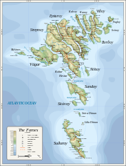
211:
1731:
182:
1686:
1501:
1436:
1426:
1411:
1416:
1661:
271:
1491:
1471:
179:
Relief shading is an embedded PNG raster, derived from ETOPO2 data.
1032:
Click on a date/time to view the file as it appeared at that time.
327:
1706:
285:
337:
334:
311:
292:
1681:
1596:
1366:
93:
1576:
87:(SVG file, nominally 1,683 × 2,208 pixels, file size: 763 KB)
264:
1651:
1511:
1406:
164:
Coastline, roads, place names, and summits based partly on
1521:
1616:
1451:
1299:
List of twin towns and sister cities in the Faroe
Islands
173:
Topography based on public domain GLOBE data from NOAA (
1627:Проект:Тематическая неделя европейских регионов/Фареры
741:
Creative
Commons Attribution-ShareAlike 3.0 Unported
724:
488:, Version 1.2 or any later version published by the
137:
117:
Commons is a freely licensed media file repository.
185:(low resolution raster with a "blur" property).
455:https://creativecommons.org/licenses/by-sa/3.0
175:http://www.ngdc.noaa.gov/mgg/topo/gltiles.html
98:
461:Creative Commons Attribution-Share Alike 3.0
375:
8:
1632:Список населённых пунктов Фарерских островов
421:– to copy, distribute and transmit the work
46:Size of this PNG preview of this SVG file:
1749:
1537:Occupazione britannica delle isole Fær Øer
1034:
551:
543:
535:
520:You may select the license of your choice.
1334:The following other wikis use this file:
880:d4863c6c0d21a41377729654e635ada307b4b478
1759:
1751:
1284:British occupation of the Faroe Islands
1281:
1007:
991:
970:
954:
933:
917:
878:
862:
844:
828:
810:
794:
774:
758:
738:
721:
705:
685:
669:
651:http://commons.wikimedia.org/User:Mysid
602:
586:
569:
566:
531:
524:
1387:Ocupación británica de las islas Feroe
1279:The following 9 pages use this file:
153:Topographic map of the Faroe Islands.
7:
1527:Listi yfir þéttbýlisstaði í Færeyjum
500:http://www.gnu.org/copyleft/fdl.html
398:Attribution-Share Alike 3.0 Unported
1357:ব্যবহারকারী:Pasaban/ফারো দ্বীপপুঞ্জ
1023:
386:
381:
1742:
1672:Британска окупација Фарских острва
1457:Knowledge:Mánaðargreinin/juni 2011
1268:Category:Maps of the Faroe Islands
560:
554:
546:
538:
519:
372:
364:
332:
309:
290:
269:
155:
147:
130:
80:
1377:Κατάλογος νησιών των Νήσων Φερόες
559:
529:
476:
475:
432:Under the following conditions:
393:This file is licensed under the
385:
380:
374:
326:
303:
284:
263:
97:
31:
21:
526:
247:Map of the Faroe Islands pl.svg
242:Map of the Faroe Islands fr.svg
237:Map of the Faroe Islands es.svg
232:Map of the Faroe Islands de.svg
227:Map of the Faroe Islands af.svg
222:Derivative works of this file:
161:Färsaarten topografinen kartta.
156:
148:
143:Map of the Faroe Islands en.svg
14:
1713:Usage on zh-yue.wikipedia.org
1294:List of early Germanic peoples
525:
506:GNU Free Documentation License
495:GNU Free Documentation License
485:GNU Free Documentation License
26:
1:
1697:Транспорт Фарерських Островів
1442:Malline:Valitut palat/2022/23
1432:Malline:Valitut palat/2017/36
1422:Malline:Valitut palat/2013/50
777:original creation by uploader
36:
1304:Outline of the Faroe Islands
567:Items portrayed in this file
1703:Usage on vls.wikipedia.org
1648:Usage on sco.wikipedia.org
1638:Usage on scn.wikipedia.org
1583:Usage on lez.wikipedia.org
1468:Usage on frr.wikipedia.org
1462:Knowledge:Mánaðargrein 2011
1363:Usage on dsb.wikipedia.org
1781:
1723:Usage on zh.wikipedia.org
1693:Usage on uk.wikipedia.org
1678:Usage on sv.wikipedia.org
1668:Usage on sr.wikipedia.org
1658:Usage on sc.wikipedia.org
1623:Usage on ru.wikipedia.org
1613:Usage on nl.wikipedia.org
1603:Usage on mk.wikipedia.org
1593:Usage on mi.wikipedia.org
1573:Usage on lb.wikipedia.org
1563:Usage on ko.wikipedia.org
1557:Фарер аралдарының қалалары
1553:Usage on kk.wikipedia.org
1543:Usage on ka.wikipedia.org
1533:Usage on it.wikipedia.org
1518:Usage on is.wikipedia.org
1508:Usage on ia.wikipedia.org
1498:Usage on hu.wikipedia.org
1488:Usage on ga.wikipedia.org
1478:Usage on fr.wikipedia.org
1448:Usage on fo.wikipedia.org
1437:Malline:Valitut palat/2022
1427:Malline:Valitut palat/2017
1412:Malline:Valitut palat/2013
1403:Usage on fi.wikipedia.org
1393:Usage on fa.wikipedia.org
1383:Usage on es.wikipedia.org
1373:Usage on el.wikipedia.org
1353:Usage on bn.wikipedia.org
1338:Usage on bg.wikipedia.org
446:same or compatible license
1024:
201:
16:
1587:Фарер островрин шегьерар
1172:better choices for fonts
528:
490:Free Software Foundation
412:
104:This is a file from the
1261:
1231:
1201:
1171:
1141:
1111:
1090:20:34, 11 February 2024
1081:
1060:20:53, 11 February 2024
217:
207:
197:
192:
189:
140:
108:. Information from its
1240:18:52, 28 January 2009
1210:19:21, 28 January 2009
1180:19:22, 28 January 2009
318:text that can be
193:2009-01-28, 2024-02-11
111:description page there
1417:Färsaarten maantiede
1319:User:Mysid/imagenavi
1142:oops, legend missing
892:determination method
539:Map of Faroe islands
322:using a text editor.
255:SVG development
74:1,683 × 2,208 pixels
70:1,561 × 2,048 pixels
1150:09:16, 19 July 2010
1120:09:18, 19 July 2010
427:– to adapt the work
52:Other resolutions:
1324:User:Mysid/vectors
1202:remove ext. images
629:Wikimedia username
616:author name string
66:780 × 1,024 pixels
1768:
1767:
1547:ფარერის კუნძულები
1347:Фарьорски острови
1330:Global file usage
1272:
1232:embed all rasters
708:copyright license
555:Mapa wysp owczych
553:
545:
537:
517:
516:
355:
354:
320:easily translated
295:was created with
126:
125:
106:Wikimedia Commons
32:Global file usage
1772:
1750:
1502:Feröer földrajza
1314:User:Mysid/audio
1252:
1222:
1192:
1162:
1132:
1102:
1072:
1012:
975:
938:
901:
896:
672:copyright status
653:
648:
638:
633:
623:
620:
513:
510:
507:
504:
501:
479:
478:
472:
468:
465:
462:
459:
456:
448:as the original.
410:
395:Creative Commons
389:
388:
384:
383:
378:
377:
330:
317:
307:
288:
279:
267:
203:
181:Bathymetry from
160:
152:
144:
138:
122:
101:
100:
94:
88:
77:
62:585 × 768 pixels
58:366 × 480 pixels
54:183 × 240 pixels
48:457 × 600 pixels
1780:
1779:
1775:
1774:
1773:
1771:
1770:
1769:
1738:
1328:
1273:
1258:
1250:
1228:
1220:
1198:
1190:
1168:
1160:
1138:
1130:
1108:
1100:
1078:
1070:
1026:
1025:
1022:
1021:
1020:
1019:
1018:
1017:
1016:
1015:
1013:
1010:
1000:
999:
998:
996:
985:
984:
983:
982:
981:
980:
979:
978:
976:
973:
963:
962:
961:
959:
948:
947:
946:
945:
944:
943:
942:
941:
939:
936:
926:
925:
924:
922:
911:
910:
909:
908:
907:
906:
905:
904:
903:
902:
897:
894:
885:
884:
883:
881:
871:
870:
869:
867:
856:
855:
854:
853:
852:
851:
850:
849:
847:
837:
836:
835:
833:
822:
821:
820:
819:
818:
817:
816:
815:
813:
812:28 January 2009
803:
802:
801:
799:
788:
787:
786:
785:
784:
783:
782:
781:
779:
767:
766:
765:
763:
752:
751:
750:
749:
748:
747:
746:
745:
743:
732:
731:
730:
729:
728:
726:
714:
713:
712:
710:
699:
698:
697:
696:
695:
694:
693:
692:
690:
678:
677:
676:
674:
663:
662:
661:
660:
659:
658:
657:
656:
655:
654:
649:
646:
640:
639:
634:
631:
625:
624:
621:
618:
609:
608:
607:
605:
595:
594:
593:
591:
580:
579:
578:
577:
576:
574:
558:
557:
556:
549:
548:
547:Feröer szigetek
541:
540:
523:
522:
521:
511:
508:
505:
502:
499:
470:
469:
466:
463:
460:
457:
454:
453:
411:
405:Oona Räisänen (
404:
401:
390:
371:
370:
365:Oona Räisänen (
361:
356:
351:
350:
349:
342:raster graphics
324:
323:
315:
301:
300:
282:
281:
275:
258:
162:
154:
142:
135:
128:
127:
116:
115:
114:is shown below.
90:
86:
79:
78:
51:
12:
11:
5:
1778:
1776:
1766:
1765:
1762:
1758:
1757:
1754:
1741:
1737:
1736:
1735:
1734:
1729:
1721:
1720:
1719:
1711:
1710:
1709:
1707:Faeröereilandn
1701:
1700:
1699:
1691:
1690:
1689:
1684:
1676:
1675:
1674:
1666:
1665:
1664:
1662:Ìsulas Føroyar
1656:
1655:
1654:
1646:
1645:
1644:
1636:
1635:
1634:
1629:
1621:
1620:
1619:
1611:
1610:
1609:
1607:Фарски Острови
1601:
1600:
1599:
1591:
1590:
1589:
1581:
1580:
1579:
1571:
1570:
1569:
1561:
1560:
1559:
1551:
1550:
1549:
1541:
1540:
1539:
1531:
1530:
1529:
1524:
1516:
1515:
1514:
1512:Insulas Faeroe
1506:
1505:
1504:
1496:
1495:
1494:
1486:
1485:
1484:
1476:
1475:
1474:
1466:
1465:
1464:
1459:
1454:
1446:
1445:
1444:
1439:
1434:
1429:
1424:
1419:
1414:
1409:
1401:
1400:
1399:
1391:
1390:
1389:
1381:
1380:
1379:
1371:
1370:
1369:
1361:
1360:
1359:
1351:
1350:
1349:
1344:
1332:
1331:
1327:
1326:
1321:
1316:
1311:
1306:
1301:
1296:
1291:
1286:
1277:
1276:
1271:
1270:
1260:
1256:
1253:
1249:1,683 × 2,208
1247:
1242:
1237:
1234:
1233:
1230:
1226:
1223:
1219:1,683 × 2,208
1217:
1212:
1207:
1204:
1203:
1200:
1196:
1193:
1189:1,683 × 2,208
1187:
1182:
1177:
1174:
1173:
1170:
1166:
1163:
1159:1,683 × 2,208
1157:
1152:
1147:
1144:
1143:
1140:
1136:
1133:
1129:1,683 × 2,208
1127:
1122:
1117:
1114:
1113:
1110:
1106:
1103:
1099:1,683 × 2,208
1097:
1092:
1087:
1084:
1083:
1080:
1076:
1073:
1069:1,683 × 2,208
1067:
1062:
1057:
1053:
1052:
1049:
1046:
1043:
1040:
1037:
1030:
1029:
1014:
1008:
1006:
1005:
1004:
1003:
1002:
1001:
997:
992:
990:
989:
988:
987:
986:
977:
971:
969:
968:
967:
966:
965:
964:
960:
955:
953:
952:
951:
950:
949:
940:
934:
932:
931:
930:
929:
928:
927:
923:
918:
916:
915:
914:
913:
912:
890:
889:
888:
887:
886:
882:
879:
877:
876:
875:
874:
873:
872:
868:
863:
861:
860:
859:
858:
857:
848:
845:
843:
842:
841:
840:
839:
838:
834:
829:
827:
826:
825:
824:
823:
814:
811:
809:
808:
807:
806:
805:
804:
800:
795:
793:
792:
791:
790:
789:
780:
775:
773:
772:
771:
770:
769:
768:
764:
761:source of file
759:
757:
756:
755:
754:
753:
744:
739:
737:
736:
735:
734:
733:
727:
722:
720:
719:
718:
717:
716:
715:
711:
706:
704:
703:
702:
701:
700:
691:
686:
684:
683:
682:
681:
680:
679:
675:
670:
668:
667:
666:
665:
664:
642:
641:
627:
626:
614:
613:
612:
611:
610:
606:
603:
601:
600:
599:
598:
597:
596:
592:
587:
585:
584:
583:
582:
581:
575:
570:
568:
565:
564:
563:
562:
561:
550:
542:
534:
533:
530:
527:
518:
515:
514:
480:
452:
451:
450:
449:
439:
430:
429:
428:
422:
415:You are free:
402:
392:
391:
373:
363:
362:
360:
357:
353:
352:
340:uses embedded
325:
302:
283:
262:
261:
259:
256:
252:
251:
250:
249:
244:
239:
234:
229:
219:
218:Other versions
215:
214:
209:
205:
204:
199:
195:
194:
191:
187:
186:
145:
136:
134:
131:
129:
124:
123:
102:
92:
91:
45:
41:
40:
39:
34:
29:
24:
19:
13:
10:
9:
6:
4:
3:
2:
1777:
1763:
1760:
1755:
1752:
1748:
1745:
1739:
1733:
1730:
1728:
1725:
1724:
1722:
1718:
1715:
1714:
1712:
1708:
1705:
1704:
1702:
1698:
1695:
1694:
1692:
1688:
1685:
1683:
1680:
1679:
1677:
1673:
1670:
1669:
1667:
1663:
1660:
1659:
1657:
1653:
1652:Faroe Islands
1650:
1649:
1647:
1643:
1642:Ìsuli Fær Øer
1640:
1639:
1637:
1633:
1630:
1628:
1625:
1624:
1622:
1618:
1615:
1614:
1612:
1608:
1605:
1604:
1602:
1598:
1597:Moutere Whāro
1595:
1594:
1592:
1588:
1585:
1584:
1582:
1578:
1575:
1574:
1572:
1568:
1565:
1564:
1562:
1558:
1555:
1554:
1552:
1548:
1545:
1544:
1542:
1538:
1535:
1534:
1532:
1528:
1525:
1523:
1520:
1519:
1517:
1513:
1510:
1509:
1507:
1503:
1500:
1499:
1497:
1493:
1492:Oileáin Fharó
1490:
1489:
1487:
1483:
1480:
1479:
1477:
1473:
1470:
1469:
1467:
1463:
1460:
1458:
1455:
1453:
1450:
1449:
1447:
1443:
1440:
1438:
1435:
1433:
1430:
1428:
1425:
1423:
1420:
1418:
1415:
1413:
1410:
1408:
1405:
1404:
1402:
1398:
1395:
1394:
1392:
1388:
1385:
1384:
1382:
1378:
1375:
1374:
1372:
1368:
1365:
1364:
1362:
1358:
1355:
1354:
1352:
1348:
1345:
1343:
1340:
1339:
1337:
1336:
1335:
1329:
1325:
1322:
1320:
1317:
1315:
1312:
1310:
1307:
1305:
1302:
1300:
1297:
1295:
1292:
1290:
1289:Faroe Islands
1287:
1285:
1282:
1280:
1274:
1269:
1265:
1259:
1254:
1248:
1246:
1243:
1241:
1238:
1236:
1235:
1229:
1224:
1218:
1216:
1213:
1211:
1208:
1206:
1205:
1199:
1194:
1188:
1186:
1183:
1181:
1178:
1176:
1175:
1169:
1164:
1158:
1156:
1153:
1151:
1148:
1146:
1145:
1139:
1134:
1128:
1126:
1123:
1121:
1118:
1116:
1115:
1109:
1104:
1098:
1096:
1093:
1091:
1088:
1086:
1085:
1079:
1074:
1068:
1066:
1063:
1061:
1058:
1055:
1054:
1050:
1047:
1044:
1041:
1038:
1036:
1035:
1033:
1027:
995:
958:
921:
900:
893:
866:
846:image/svg+xml
832:
798:
778:
762:
742:
725:
709:
689:
673:
652:
645:
637:
630:
622:Oona Räisänen
617:
590:
573:
497:
496:
491:
487:
486:
481:
474:
473:
458:CC BY-SA 3.0
447:
443:
440:
437:
434:
433:
431:
426:
423:
420:
417:
416:
414:
413:
408:
403:Attribution:
399:
396:
379:
368:
358:
347:
343:
339:
336:
329:
321:
313:
306:
298:
294:
287:
278:
273:
266:
260:
254:
253:
248:
245:
243:
240:
238:
235:
233:
230:
228:
225:
224:
223:
220:
216:
213:
212:Oona Räisänen
210:
206:
200:
196:
188:
184:
180:
178:
176:
172:
171:
169:
167:
159:
151:
146:
139:
132:
120:
113:
112:
107:
103:
96:
95:
89:
84:
83:Original file
75:
71:
67:
63:
59:
55:
49:
44:
38:
35:
33:
30:
28:
25:
23:
20:
18:
15:
1746:
1743:
1333:
1278:
1031:
1028:File history
493:
483:
441:
435:
424:
418:
344:to show its
333: This
221:
163:
157:
149:
119:You can help
109:
81:
22:File history
1687:Färöisk gås
688:copyrighted
442:share alike
436:attribution
348:structures.
346:topographic
183:NGDC ETOPO2
141:Description
1397:جزایر فارو
1309:User:Mysid
1275:File usage
1045:Dimensions
831:media type
604:some value
27:File usage
1764:2207.7141
1756:1682.8121
1407:Färsaaret
1342:Архипелаг
1042:Thumbnail
1039:Date/Time
920:data size
797:inception
544:Hungarian
359:Licensing
257:InfoField
150:English:
1740:Metadata
1682:Färöarna
1522:Færeyjar
1251:(653 KB)
1221:(694 KB)
1191:(694 KB)
1161:(539 KB)
1131:(539 KB)
1101:(733 KB)
1071:(763 KB)
935:551,652
865:checksum
532:Captions
425:to remix
419:to share
400:license.
316:embedded
297:Inkscape
274:code is
202:Own work
37:Metadata
1617:Faeröer
1472:Fääröer
1452:Føroyar
1056:current
1051:Comment
589:creator
572:depicts
536:English
158:Suomi:
133:Summary
85:
1761:Height
1577:Färöer
1367:Färöje
1009:1,683
972:2,208
957:height
552:Polish
331:
314:uses
308:
291:This
289:
268:
208:Author
198:Source
1753:Width
1567:페로 제도
1264:Mysid
1257:Mysid
1227:Mysid
1197:Mysid
1167:Mysid
1137:Mysid
1107:Mysid
1077:Mysid
1011:pixel
994:width
974:pixel
899:SHA-1
636:Mysid
407:Mysid
367:Mysid
310:This
277:valid
1727:法罗群岛
1717:法羅群島
1048:User
937:byte
512:true
509:true
503:GFDL
467:true
464:true
270:The
190:Date
17:File
1732:法羅人
644:URL
338:map
335:SVG
312:map
293:map
272:SVG
895::
647::
632::
619::
177:).
72:|
68:|
64:|
60:|
56:|
50:.
498:.
409:)
299:.
280:.
168:.
121:.
76:.
Text is available under the Creative Commons Attribution-ShareAlike License. Additional terms may apply.
