313:
229:
319:
43:
103:
622:
592:
360:– You must give appropriate credit, provide a link to the license, and indicate if changes were made. You may do so in any reasonable manner, but not in any way that suggests the licensor endorses you or your use.
248:
The ODbL does not require any particular license for maps produced from ODbL data. Prior to 1 August 2020, map tiles produced by the OpenStreetMap
Foundation were licensed under the
643:|top = |bottom = |left = |right = |date = 2024-04-24 |authors = |other_versions = }} =={{int:license-header}}== {{self|cc-by-3.0}}
205:
503:
467:
431:
693:
This file contains additional information, probably added from the digital camera or scanner used to create or digitize it.
646:
523:
451:
487:
415:
69:
65:
61:
57:
53:
47:
114:
696:
If the file has been modified from its original state, some details may not fully reflect the modified file.
644:
621:
616:
82:
658:
The following pages on the
English Knowledge (XXG) use this file (pages on other projects are not listed):
329:
326:
632:
602:
122:
223:
724:
164:
This map may be incomplete, and may contain errors. Don't rely solely on it for navigation.
154:
279:
109:
306:
I, the copyright holder of this work, hereby publish it under the following license:
662:
640:
591:
586:
249:
73:
42:
639:== {{int:filedesc}} == {{OpenStreetMap |name = |location = |description = The
241:
174:
159:
214:
218:
228:
141:
559:
Click on a date/time to view the file as it appeared at that time.
221:). Standard style map tiles are licensed as ODbL Produced Works.
252:. Maps produced by other people may be subject to other licences.
237:
184:
97:
399:
Add a one-line explanation of what this file represents
288:
If inappropriate please set warp_status = skip to hide.
87:(5,774 × 5,617 pixels, file size: 11.93 MB, MIME type:
680:
121:
Commons is a freely licensed media file repository.
102:
312:
261:http://opendatacommons.org/licenses/odbl/1.0/
8:
367:https://creativecommons.org/licenses/by/3.0
343:– to copy, distribute and transmit the work
698:
561:
395:
213:OpenStreetMap data is available under the
162:project data, collected by the community.
673:The following other wikis use this file:
504:Creative Commons Attribution 3.0 Unported
721:
716:
708:
700:
660:
537:
521:
501:
485:
465:
449:
429:
413:
410:
391:
384:
282:Georeference the map in Wikimaps Warper
647:Category:Rail transport maps of Wales
7:
240:, which is made available under the
236:This work contains information from
550:
318:
691:
404:
398:
334:
309:
305:
134:
80:
403:
373:Creative Commons Attribution 3.0
389:
354:Under the following conditions:
325:This file is licensed under the
317:
311:
227:
101:
31:
21:
386:
14:
385:
26:
1:
280:
36:
411:Items portrayed in this file
242:Open Database License (ODbL)
226:
158:This map was created from
746:
677:Usage on www.wikidata.org
195:OpenStreetMap contributors
551:
16:
388:
330:Attribution 3.0 Unported
108:This is a file from the
638:
608:
274:
200:
190:
180:
170:
144:
112:. Information from its
115:description page there
46:Size of this preview:
702:Horizontal resolution
255:Open Database License
215:Open Database License
617:22:25, 24 April 2024
587:22:38, 24 April 2024
250:CC-BY-SA-2.0 license
74:5,774 × 5,617 pixels
70:2,105 × 2,048 pixels
66:1,053 × 1,024 pixels
710:Vertical resolution
349:– to adapt the work
52:Other resolutions:
733:
732:
669:Global file usage
651:
488:copyright license
397:
293:
292:
289:
270:
269:
253:
209:
206:Reusing this file
185:openstreetmap.org
165:
130:
129:
110:Wikimedia Commons
32:Global file usage
737:
727:
725:www.inkscape.org
699:
629:
599:
452:copyright status
380:
377:
374:
371:
368:
327:Creative Commons
321:
320:
315:
314:
287:
286:
284:
283:
265:
262:
259:
256:
247:
231:
224:
203:
176:
163:
148:
147:Merthyr line.png
142:
126:
105:
104:
98:
92:
90:
77:
62:789 × 768 pixels
58:493 × 480 pixels
54:247 × 240 pixels
48:616 × 599 pixels
745:
744:
740:
739:
738:
736:
735:
734:
723:
687:
667:
659:
652:
641:en:Merthyr line
635:
627:
605:
597:
553:
552:
549:
548:
547:
546:
545:
544:
543:
542:
540:
530:
529:
528:
526:
515:
514:
513:
512:
511:
510:
509:
508:
506:
494:
493:
492:
490:
479:
478:
477:
476:
475:
474:
473:
472:
470:
458:
457:
456:
454:
443:
442:
441:
440:
439:
438:
437:
436:
434:
422:
421:
420:
418:
402:
401:
400:
383:
382:
381:
378:
375:
372:
369:
366:
365:
333:
322:
308:
307:
302:
294:
281:
278:
263:
260:
257:
254:
196:
166:
157:
146:
139:
132:
131:
120:
119:
118:is shown below.
94:
88:
86:
79:
78:
51:
12:
11:
5:
743:
741:
731:
730:
729:
728:
719:
715:
714:
711:
707:
706:
703:
690:
686:
685:
684:
683:
671:
670:
666:
665:
657:
656:
655:
650:
649:
637:
633:
630:
626:5,774 × 5,617
624:
619:
614:
611:
610:
607:
603:
600:
596:5,774 × 5,617
594:
589:
584:
580:
579:
576:
573:
570:
567:
564:
557:
556:
541:
538:
536:
535:
534:
533:
532:
531:
527:
522:
520:
519:
518:
517:
516:
507:
502:
500:
499:
498:
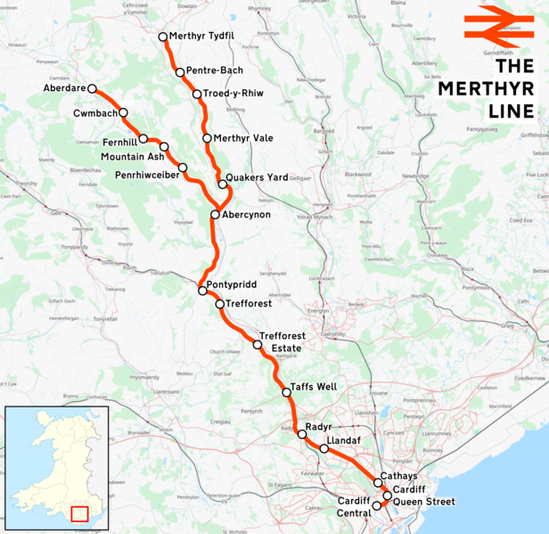
497:
496:
495:
491:
486:
484:
483:
482:
481:
480:
471:
466:
464:
463:
462:
461:
460:
459:
455:
450:
448:
447:
446:
445:
444:
435:
430:
428:
427:
426:
425:
424:
423:
419:
414:
412:
409:
408:
407:
406:
405:
394:
393:
390:
387:
364:
363:
362:
361:
352:
351:
350:
344:
337:You are free:
324:
323:
310:
304:
303:
301:
298:
291:
290:
276:
275:Georeferencing
272:
271:
268:
267:
234:
232:
210:
198:
197:
194:
192:
188:
187:
182:
178:
177:
172:
168:
167:
152:
151:
149:
140:
138:
135:
133:
128:
127:
106:
96:
95:
45:
41:
40:
39:
34:
29:
24:
19:
13:
10:
9:
6:
4:
3:
2:
742:
726:
722:
720:
718:Software used
717:
712:
709:
704:
701:
697:
694:
688:
682:
679:
678:
676:
675:
674:
668:
664:
661:
653:
648:
645:
642:
636:
634:Rcsprinter123
631:
625:
623:
620:
618:
615:
613:
612:
606:
604:Rcsprinter123
601:
595:
593:
590:
588:
585:
582:
581:
577:
574:
571:
568:
565:
563:
562:
560:
554:
525:
505:
489:
469:
453:
433:
417:
359:
356:
355:
353:
348:
345:
342:
339:
338:
336:
335:
331:
328:
316:
299:
297:
296:
285:
277:
273:
266:
251:
245:
243:
239:
238:OpenStreetMap
235:
233:
230:
225:
222:
220:
216:
211:
207:
202:
199:
193:
189:
186:
183:
179:
175:24 April 2024
173:
169:
161:
160:OpenStreetMap
156:
150:
143:
136:
124:
117:
116:
111:
107:
100:
99:
93:
84:
83:Original file
75:
71:
67:
63:
59:
55:
49:
44:
38:
35:
33:
30:
28:
25:
23:
20:
18:
15:
695:
692:
672:
663:Merthyr line
558:
555:File history
432:Merthyr Line
357:
346:
340:
295:
246:
212:
155:Merthyr line
123:You can help
113:
81:
22:File history
468:copyrighted
358:attribution
145:Description
713:118.11 dpc
705:118.11 dpc
654:File usage
628:(11.98 MB)
598:(11.93 MB)
572:Dimensions
524:media type
370:CC BY 3.0
201:Permission
27:File usage
569:Thumbnail
566:Date/Time
539:image/png
300:Licensing
89:image/png
689:Metadata
681:Q6820676
392:Captions
347:to remix
341:to share
332:license.
37:Metadata
583:current
578:Comment
416:depicts
396:English
219:details
191:Creator
137:Summary
85:
181:Source
575:User
379:true
376:true
264:true
258:ODbL
171:Date
153:The
17:File
244:.
72:|
68:|
64:|
60:|
56:|
50:.
609:.
217:(
208:)
204:(
125:.
91:)
76:.
Text is available under the Creative Commons Attribution-ShareAlike License. Additional terms may apply.
