264:
215:
253:
82:
38:
636:
705:
357:
653:{{Information |Description=NASA satellite photograph showing the Barotse Floodplain as the bright green to dark blue central region. |Source= ''NASA/Visible Earth''
48:
42:
93:
61:
181:
336:
joint project implies that all materials created by its probe are copyrighted and require permission for commercial non-educational use.
353:
333:
166:
311:
385:
confluence of (left to right) the
Lungwebungu, Southern Kashiji, Zambezi and Kabompo Rivers, marking the start of the floodplain;
285:
546:
511:
343:
296:
524:
495:
646:
567:
539:
478:
531:
667:
307:
663:
The following pages on the
English Knowledge (XXG) use this file (pages on other projects are not listed):
149:, Credit: Jacques Descloitres, MODIS Rapid Response Team, NASA/GSFC. Labels added by User:Rexparry_sydney
125:
NASA satellite photograph showing the
Barotse Floodplain as the bright green to dark blue central region.
292:
635:
630:
361:
52:
37:
364:
states that all of the images in the photo gallery are in the public domain "Unless otherwise noted."
101:
337:
429:
a broad floodplain which carries overspill from high floods of the Cuando River in Angola;
348:
324:
318:
240:
236:
223:
88:
143:
231:. NASA copyright policy states that "NASA material is not protected by copyright
133:
281:
685:
381:
The
Zambezi flowing north to south through the middle of the floodplain;
695:
244:
433:
Cuando river and floodplain, on the border between Angola and Zambia;
603:
Click on a date/time to view the file as it appeared at that time.
315:
310:
data may be copyrighted if they are not explicitly produced by the
228:
441:
The flat sandy Miombo woodland west of Mongu features many pans;
157:
Credit: Jacques
Descloitres, MODIS Rapid Response Team, NASA/GSFC
209:
76:
262:
251:
413:
the
Kabompo drains an area of Cryptosepalum dry forest;
291:
The NASA website hosts a large number of images from the
462:
Add a one-line explanation of what this file represents
227:
in the United States because it was solely created by
115:
100:
Commons is a freely licensed media file repository.
547:
work of the federal government of the United States
299:, and other non-American space agencies. These are
405:Limulunga, seat of the Litunga during the flood;
284:, insignia and emblems is restricted per U.S. law
66:(538 × 867 pixels, file size: 1.13 MB, MIME type:
401:Lealui, seat of the Litunga on the floodplain;
81:
8:
182:Image:NASA Barotse Floodplain compressed.JPG
409:swamps and floodplain of the Lungwebungu;
605:
458:
189:
678:The following other wikis use this file:
421:Luanginga River floodplain near Kalabo;
389:end of the floodplain south of Senanga;
665:
581:
565:
509:
493:
476:
473:
454:
447:
144:"Seasonal Flooding in Southern Africa".
214:
7:
356:(NSSDC) site has been known to host
347:(APOD) web site may be copyrighted.
121:NASA Image of Barotse Floodplain.PNG
594:
425:Lui River with narrow floodplain;
467:
461:
354:National Space Science Data Center
113:
59:
466:
452:
397:Mongu, capital of Barotseland;
213:
80:
31:
21:
449:
14:
448:
393:Ngonye Falls on the Zambezi;
26:
1:
696:Parques nacionales de Zambia
474:Items portrayed in this file
445:Sioma Ngwezi National Park.
344:Astronomy Picture of the Day
648:Rexparry sydney~commonswiki
437:Liuwa Plain National Park;
724:
706:സിയോമ ൻഗ്വെസി ദേശീയോദ്യാനം
702:Usage on ml.wikipedia.org
692:Usage on es.wikipedia.org
682:Usage on ca.wikipedia.org
668:Sioma Ngwezi National Park
417:Luena Flats (floodplain);
241:NASA copyright policy page
686:Parcs Nacionals de Zàmbia
595:
16:
532:United States of America
451:
87:This is a file from the
652:
631:05:40, 19 November 2007
525:applies to jurisdiction
341:Images featured on the
177:
161:
153:
139:
132:
129:
118:
91:. Information from its
308:Hubble Space Telescope
267:
256:
94:description page there
41:Size of this preview:
334:SOHO (ESA & NASA)
303:in the public domain.
266:
255:
540:determination method
297:Russian space agency
245:JPL Image Use Policy
221:This file is in the
358:copyrighted content
306:Materials based on
47:Other resolutions:
268:
257:
147:NASA/Visible Earth
674:Global file usage
656:
460:
371:
370:
362:photo gallery FAQ
275:
237:Template:PD-USGov
208:
207:
187:
186:
170:
167:Reusing this file
109:
108:
89:Wikimedia Commons
32:Global file usage
715:
643:
549:
544:
534:
529:
496:copyright status
327:
321:
271:
265:
254:
217:
216:
210:
204:
201:
198:
195:
190:
164:
135:
122:
116:
105:
84:
83:
77:
71:
69:
56:
53:538 × 867 pixels
49:149 × 240 pixels
43:372 × 599 pixels
723:
722:
718:
717:
716:
714:
713:
712:
672:
664:
657:
649:
641:
597:
596:
593:
592:
591:
590:
589:
588:
587:
586:
584:
574:
573:
572:
570:
559:
558:
557:
556:
555:
554:
553:
552:
551:
550:
545:
542:
536:
535:
530:
527:
518:
517:
516:
514:
502:
501:
500:
498:
487:
486:
485:
484:
483:
481:
465:
464:
463:
376:
367:
325:
319:
301:not necessarily
263:
252:
202:
199:
196:
193:
188:
120:
111:
110:
99:
98:
97:is shown below.
73:
67:
65:
58:
57:
46:
12:
11:
5:
721:
719:
711:
710:
709:
708:
700:
699:
698:
690:
689:
688:
676:
675:
671:
670:
662:
661:
660:
655:
654:
651:
647:
644:
638:
633:
628:
624:
623:
620:
617:
614:
611:
608:
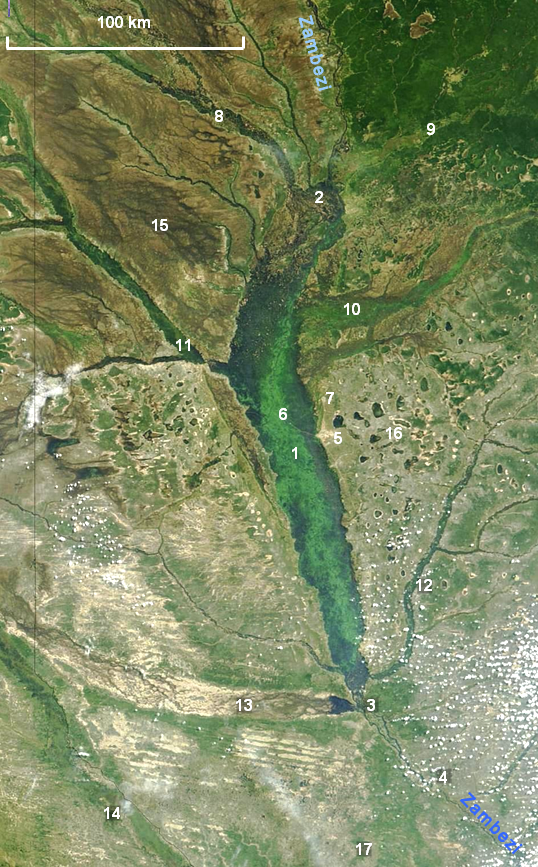
601:
600:
585:
582:
580:
579:
578:
577:
576:
575:
571:
566:
564:
563:
562:
561:
560:
538:
537:
523:
522:
521:
520:
519:
515:
510:
508:
507:
506:
505:
504:
503:
499:
494:
492:
491:
490:
489:
488:
482:
477:
475:
472:
471:
470:
469:
468:
457:
456:
453:
450:
375:
372:
369:
368:
366:
365:
350:
339:
330:
304:
289:
277:
269:
259:
258:
249:
218:
206:
205:
185:
184:
179:
178:Other versions
175:
174:
171:
159:
158:
155:
151:
150:
141:
137:
136:
131:
127:
126:
123:
114:
112:
107:
106:
85:
75:
74:
40:
36:
35:
34:
29:
24:
19:
13:
10:
9:
6:
4:
3:
2:
720:
707:
704:
703:
701:
697:
694:
693:
691:
687:
684:
683:
681:
680:
679:
673:
669:
666:
658:
650:
645:
639:
637:
634:
632:
629:
626:
625:
621:
618:
615:
612:
609:
607:
606:
604:
598:
583:24 April 2004
569:
548:
541:
533:
526:
513:
512:public domain
497:
480:
446:
444:
440:
436:
432:
428:
424:
420:
416:
412:
408:
404:
400:
396:
392:
388:
384:
380:
373:
363:
359:
355:
351:
349:
346:
345:
340:
338:
335:
331:
328:
326:{{Cc-Hubble}}
322:
320:{{PD-Hubble}}
316:
313:
309:
305:
302:
298:
294:
290:
287:
283:
279:
278:
276:
274:
270:
261:
260:
250:
248:
246:
242:
238:
234:
230:
226:
225:
224:public domain
219:
212:
211:
197:Public domain
194:Public domain
192:
191:
183:
180:
176:
172:
168:
163:
160:
156:
152:
148:
145:
142:
138:
134:24 April 2004
128:
124:
117:
103:
96:
95:
90:
86:
79:
78:
72:
63:
62:Original file
54:
50:
44:
39:
33:
30:
28:
25:
23:
20:
18:
15:
677:
602:
599:File history
442:
438:
434:
430:
426:
422:
418:
414:
410:
406:
402:
398:
394:
390:
386:
382:
378:
377:
342:
300:
272:
233:unless noted
232:
222:
220:
173:NASA general
146:
102:You can help
92:
60:
22:File history
286:14 CFR 1221
119:Description
659:File usage
640:538 × 867
616:Dimensions
282:NASA logos
162:Permission
27:File usage
642:(1.13 MB)
613:Thumbnail
610:Date/Time
568:inception
317:See also
273:Warnings:
68:image/png
455:Captions
235:". (See
627:current
622:Comment
479:depicts
459:English
280:Use of
64:
360:. Its
293:Soviet
154:Author
140:Source
312:STScI
203:false
200:false
619:User
352:The
332:The
323:and
229:NASA
130:Date
17:File
374:Key
243:or
543::
528::
443:17
439:16
435:15
431:14
427:13
423:12
419:11
415:10
411:9
407:8
403:7
399:6
395:5
391:4
387:3
383:2
247:.)
239:,
51:|
45:.
379:1
329:.
314:.
295:/
288:.
169:)
165:(
104:.
70:)
55:.
Text is available under the Creative Commons Attribution-ShareAlike License. Additional terms may apply.