38:
197:
203:
208:
90:
621:
144:
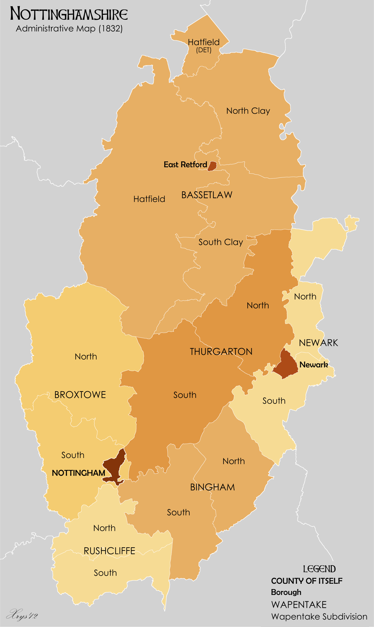
Administrative map of the county of
Nottinghamshire in 1832. Showing Wapentakes (with sub-divisions), extant Boroughs and the County of Itself of Nottingham. Wapentake boundaries from University of Nottingham English Place Name Society. Source data for parish boundaries - Kain, R.J.P., and Oliver,
591:
249:– You must give appropriate credit, provide a link to the license, and indicate if changes were made. You may do so in any reasonable manner, but not in any way that suggests the licensor endorses you or your use.
56:
52:
48:
42:
101:
69:
620:
615:
536:
466:
430:
698:
This file contains additional information, probably added from the digital camera or scanner used to create or digitize it.
256:
520:
414:
386:
371:
358:
672:
486:
450:
331:
314:
667:
218:
590:
585:
60:
37:
701:
If the file has been modified from its original state, some details may not fully reflect the modified file.
378:
648:
The following pages on the
English Knowledge (XXG) use this file (pages on other projects are not listed):
255:– If you remix, transform, or build upon the material, you must distribute your contributions under the
687:
682:
215:
652:
662:
109:
145:
R.R. (2001) "Historic parishes of
England and Wales". Unit names from Vision of Britain website.
657:
677:
393:
154:
96:
190:
I, the copyright holder of this work, hereby publish it under the following license:
631:
601:
608:
Broxtow-->Broxtowe - preferred spelling (from Vision of
Britain website)
174:
558:
Click on a date/time to view the file as it appeared at that time.
84:
298:
Add a one-line explanation of what this file represents
74:(1,195 × 2,000 pixels, file size: 337 KB, MIME type:
467:
Creative
Commons Attribution-ShareAlike 3.0 Unported
128:
108:
Commons is a freely licensed media file repository.
266:https://creativecommons.org/licenses/by-sa/3.0
89:
272:Creative Commons Attribution-Share Alike 3.0
196:
8:
232:– to copy, distribute and transmit the work
134:Nottinghamshire Administrative Map 1832.png
703:
560:
294:
713:
705:
650:
534:
518:
500:
484:
464:
448:
428:
412:
394:http://commons.wikimedia.org/User:XrysD
345:
329:
312:
309:
290:
283:
7:
219:Attribution-Share Alike 3.0 Unported
638:User created page with UploadWizard
549:
207:
202:
696:
303:
297:
193:
189:
138:
121:
67:
302:
288:
243:Under the following conditions:
214:This file is licensed under the
206:
201:
195:
88:
21:
285:
139:
14:
284:
26:
1:
537:original creation by uploader
31:
310:Items portrayed in this file
673:List of hundreds of England
735:
668:History of Nottinghamshire
257:same or compatible license
155:14 December 2012, 21:26:50
550:
164:
16:
287:
223:
95:This is a file from the
637:
616:21:29, 14 December 2012
607:
586:21:50, 14 December 2012
170:
160:
153:
150:
131:
99:. Information from its
102:description page there
41:Size of this preview:
707:Horizontal resolution
688:Thurgarton Wapentake
683:Rushcliffe Wapentake
61:1,195 × 2,000 pixels
715:Vertical resolution
653:Bassetlaw Wapentake
238:– to adapt the work
47:Other resolutions:
663:Broxtowe Wapentake
372:Wikimedia username
359:author name string
722:
721:
658:Bingham Wapentake
641:
451:copyright license
296:
180:
179:
117:
116:
97:Wikimedia Commons
726:
704:
678:Newark Wapentake
628:
598:
502:14 December 2012
415:copyright status
396:
391:
381:
376:
366:
363:
279:
276:
273:
270:
267:
259:as the original.
216:Creative Commons
210:
209:
205:
204:
199:
198:
166:
156:
143:
135:
129:
113:
92:
91:
85:
79:
77:
64:
57:459 × 768 pixels
53:287 × 480 pixels
49:143 × 240 pixels
43:358 × 599 pixels
734:
733:
729:
728:
727:
725:
724:
723:
692:
649:
642:
634:
626:
604:
596:
552:
551:
548:
547:
546:
545:
544:
543:
542:
541:
539:
527:
526:
525:
523:
512:
511:
510:
509:
508:
507:
506:
505:
503:
493:
492:
491:
489:
478:
477:
476:
475:
474:
473:
472:
471:
469:
457:
456:
455:
453:
442:
441:
440:
439:
438:
437:
436:
435:
433:
421:
420:
419:
417:
406:
405:
404:
403:
402:
401:
400:
399:
398:
397:
392:
389:
383:
382:
377:
374:
368:
367:
364:
361:
352:
351:
350:
348:
338:
337:
336:
334:
323:
322:
321:
320:
319:
317:
301:
300:
299:
282:
281:
280:
277:
274:
271:
268:
265:
264:
222:
211:
192:
191:
186:
181:
146:
133:
126:
119:
118:
107:
106:
105:is shown below.
81:
75:
73:
66:
65:
46:
12:
11:
5:
732:
730:
720:
719:
716:
712:
711:
708:
695:
691:
690:
685:
680:
675:
670:
665:
660:
655:
647:
646:
645:
640:
639:
636:
632:
629:
625:1,195 × 2,000
623:
618:
613:
610:
609:
606:
602:
599:
595:1,195 × 2,000
593:
588:
583:
579:
578:
575:
572:
569:
566:
563:
556:
555:
540:
535:
533:
532:
531:
530:
529:
528:
524:
521:source of file
519:
517:
516:
515:
514:
513:
504:
501:
499:
498:
497:
496:
495:
494:
490:
485:
483:
482:
481:
480:
479:
470:
465:
463:
462:
461:
460:
459:
458:
454:
449:
447:
446:
445:
444:
443:
434:
429:
427:
426:
425:
424:
423:
422:
418:
413:
411:
410:
409:
408:
407:
385:
384:
370:
369:
357:
356:
355:
354:
353:
349:
346:
344:
343:
342:
341:
340:
339:
335:
330:
328:
327:
326:
325:
324:
318:
313:
311:
308:
307:
306:
305:
304:
293:
292:
289:
286:
263:
262:
261:
260:
250:
241:
240:
239:
233:
226:You are free:
213:
212:
194:
188:
187:
185:
182:
178:
177:
172:
168:
167:
162:
158:
157:
152:
148:
147:
136:
127:
125:
122:
120:
115:
114:
93:
83:
82:
40:
36:
35:
34:
29:
24:
19:
13:
10:
9:
6:
4:
3:
2:
731:
717:
714:
709:
706:
702:
699:
693:
689:
686:
684:
681:
679:
676:
674:
671:
669:
666:
664:
661:
659:
656:
654:
651:
643:
635:
630:
624:
622:
619:
617:
614:
612:
611:
605:
600:
594:
592:
589:
587:
584:
581:
580:
576:
573:
570:
567:
564:
562:
561:
559:
553:
538:
522:
488:
468:
452:
432:
416:
395:
388:
380:
373:
360:
333:
316:
269:CC BY-SA 3.0
258:
254:
251:
248:
245:
244:
242:
237:
234:
231:
228:
227:
225:
224:
220:
217:
200:
183:
176:
173:
169:
163:
159:
149:
142:
137:
130:
123:
111:
104:
103:
98:
94:
87:
86:
80:
71:
70:Original file
62:
58:
54:
50:
44:
39:
33:
30:
28:
25:
23:
20:
18:
15:
700:
697:
557:
554:File history
252:
246:
235:
229:
140:
110:You can help
100:
68:
22:File history
431:copyrighted
253:share alike
247:attribution
132:Description
644:File usage
571:Dimensions
347:some value
27:File usage
718:21.44 dpc
710:21.44 dpc
568:Thumbnail
565:Date/Time
487:inception
184:Licensing
141:English:
76:image/png
694:Metadata
627:(338 KB)
597:(337 KB)
291:Captions
236:to remix
230:to share
221:license.
165:Own work
32:Metadata
582:current
577:Comment
332:creator
315:depicts
295:English
124:Summary
72:
171:Author
161:Source
633:XrysD
603:XrysD
379:XrysD
365:XrysD
175:XrysD
574:User
278:true
275:true
151:Date
17:File
387:URL
390::
375::
362::
59:|
55:|
51:|
45:.
112:.
78:)
63:.
Text is available under the Creative Commons Attribution-ShareAlike License. Additional terms may apply.