38:
256:
347:
262:
267:
94:
1053:
600:
910:
308:– You must give appropriate credit, provide a link to the license, and indicate if changes were made. You may do so in any reasonable manner, but not in any way that suggests the licensor endorses you or your use.
650:
645:
640:
635:
68:
64:
60:
56:
52:
48:
42:
935:
835:
800:
770:
621:
region showing the administrative districts. Equirectangular map projection on WGS 84 datum, with N/S stretched 170% Geographic limits: *West: 2.75W *East: 0
105:
77:
900:
930:
364:
1038:
226:
1033:
765:
1058:
231:
745:
740:
735:
685:
680:
675:
670:
665:
660:
655:
1048:
362:; with no Invariant Sections, no Front-Cover Texts, and no Back-Cover Texts. A copy of the license is included in the section entitled
354:
905:
875:
805:
925:
511:
494:
458:
958:
815:
760:
315:
442:
359:
795:
720:
531:
478:
425:
920:
790:
785:
1063:
845:
755:
715:
277:
599:
594:
37:
953:
631:
The following pages on the
English Knowledge (XXG) use this file (pages on other projects are not listed):
1008:
710:
705:
314:– If you remix, transform, or build upon the material, you must distribute your contributions under the
860:
274:
1043:
988:
915:
870:
820:
144:
190:
830:
730:
725:
618:
113:
983:
973:
895:
690:
341:
1018:
700:
352:
Permission is granted to copy, distribute and/or modify this document under the terms of the
1078:
865:
695:
187:
1073:
1028:
1023:
880:
850:
840:
610:
911:
Knowledge (XXG):WikiProject
Countries/Templates/Navboxes/European country subdivisions
890:
810:
775:
750:
249:
I, the copyright holder of this work, hereby publish it under the following licenses:
100:
825:
210:
885:
780:
176:
1013:
1003:
150:
Equirectangular map projection on WGS 84 datum, with N/S stretched 170%
855:
567:
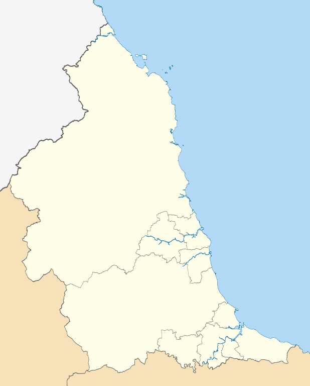
Click on a date/time to view the file as it appeared at that time.
993:
968:
88:
200:
Coastline data for Great
Britain (from Boundary-Line product)
82:(SVG file, nominally 1,082 × 1,345 pixels, file size: 697 KB)
409:
Add a one-line explanation of what this file represents
1054:Шаблон:ПозКарта Великобритания Северо-Восточная Англия
617:== Summary == {{Information |Description=Map of the
512:
Creative
Commons Attribution-ShareAlike 3.0 Unported
495:
358:, Version 1.2 or any later version published by the
132:
112:
Commons is a freely licensed media file repository.
974:Vorlage:Positionskarte England North East England
836:North East Regional Women's Football League
1079:Module:Location map/data/North East England/doc
936:Module:Location map/data/North East England/doc
984:Cathédrale Sainte-Marie de Newcastle upon Tyne
801:List of boundary changes in North East England
651:1992–93 Northern Counties East Football League
646:1991–92 Northern Counties East Football League
641:1990–91 Northern Counties East Football League
636:1989–90 Northern Counties East Football League
325:https://creativecommons.org/licenses/by-sa/3.0
197:County boundaries (from Boundary-Line product)
93:
989:Modèle:Géolocalisation/Angleterre du Nord-Est
959:وحدة:Location map/data/North East England/شرح
901:User:CSJJ104/sandbox/Second Bishops' War
771:Francis Anderson (MP for Newcastle-upon-Tyne)
331:Creative Commons Attribution-Share Alike 3.0
255:
147:region showing the administrative districts.
8:
227:NUTS 3 regions of North East England map.svg
1074:Module:Location map/data/North East England
931:Module:Location map/data/North East England
291:– to copy, distribute and transmit the work
41:Size of this PNG preview of this SVG file:
569:
405:
390:You may select the license of your choice.
954:وحدة:Location map/data/North East England
946:The following other wikis use this file:
138:North East England districts 2011 map.svg
232:North East England counties 2009 map.svg
766:Farooq E Azam Mosque and Islamic Centre
633:
545:
529:
509:
492:
476:
456:
440:
423:
420:
401:
394:
746:Counties 3 Durham & Northumberland
741:Counties 2 Durham & Northumberland
736:Counties 1 Durham & Northumberland
7:
370:http://www.gnu.org/copyleft/fdl.html
278:Attribution-Share Alike 3.0 Unported
213:, created using Ordnance Survey data
558:
266:
261:
414:
408:
389:
252:
248:
125:
75:
906:User:Phildav76/Regional templates
876:Sieges of Berwick (1355 and 1356)
806:Metropolitan Borough of Gateshead
413:
926:Portal:North East England/Topics
686:2024–25 Northern Football League
681:2023–24 Northern Football League
676:2022–23 Northern Football League
671:2021–22 Northern Football League
666:2020–21 Northern Football League
661:2019–20 Northern Football League
656:2018–19 Northern Football League
399:
346:
345:
302:Under the following conditions:
273:This file is licensed under the
265:
260:
254:
92:
31:
21:
396:
222:Derivative works of this file:
14:
816:Morpeth Chantry Bagpipe Museum
761:Darlington Hebrew Congregation
395:
376:GNU Free Documentation License
365:GNU Free Documentation License
355:GNU Free Documentation License
26:
1:
1039:Участник:ShaVas/Черновик/doc
421:Items portrayed in this file
965:Usage on frr.wikipedia.org
796:Henry Anderson (politician)
721:Borough of Stockton-on-Tees
1097:
1070:Usage on si.wikipedia.org
1000:Usage on ru.wikipedia.org
980:Usage on fr.wikipedia.org
950:Usage on ar.wikipedia.org
316:same or compatible license
921:Portal:North East England
791:Henry Anderson (merchant)
786:Henry Anderson (Cavalier)
559:
16:
1034:Участник:ShaVas/Черновик
846:Northern Football League
756:County Durham (district)
716:Borough of Middlesbrough
398:
360:Free Software Foundation
282:
99:This is a file from the
616:
217:
206:
182:
175:
172:
135:
103:. Information from its
106:description page there
711:Borough of Hartlepool
706:Borough of Darlington
861:Redcar and Cleveland
69:1,082 × 1,345 pixels
65:1,647 × 2,048 pixels
994:Prison de Frankland
916:Template:NE England
871:Saltburn-by-the-Sea
821:Newcastle upon Tyne
297:– to adapt the work
153:Geographic limits:
47:Other resolutions:
1059:Тайн-Тисское дерби
969:Nuurd Uast Ingelun
831:North East England
731:Cleveland (county)
726:City of Sunderland
701:Bishops' Wars
619:North East England
145:North East England
61:824 × 1,024 pixels
1049:Тис-Уирское дерби
942:Global file usage
896:Weardale campaign
691:Battle of Newburn
624:
595:18:56, 1 May 2011
479:copyright license
407:
387:
386:
239:
238:
121:
120:
101:Wikimedia Commons
32:Global file usage
1088:
866:Regional 2 North
696:Bertram Anderson
607:
443:copyright status
383:
380:
377:
374:
371:
349:
348:
342:
338:
335:
332:
329:
326:
318:as the original.
275:Creative Commons
269:
268:
264:
263:
258:
257:
178:
139:
133:
117:
96:
95:
89:
83:
72:
57:618 × 768 pixels
53:386 × 480 pixels
49:193 × 240 pixels
43:482 × 599 pixels
1096:
1095:
1091:
1090:
1089:
1087:
1086:
1085:
940:
632:
625:
613:
605:
561:
560:
557:
556:
555:
554:
553:
552:
551:
550:
548:
538:
537:
536:
534:
523:
522:
521:
520:
519:
518:
517:
516:
514:
503:
502:
501:
500:
499:
497:
485:
484:
483:
481:
470:
469:
468:
467:
466:
465:
464:
463:
461:
449:
448:
447:
445:
434:
433:
432:
431:
430:
428:
412:
411:
410:
393:
392:
391:
381:
378:
375:
372:
369:
340:
339:
336:
333:
330:
327:
324:
323:
281:
270:
251:
250:
245:
240:
188:Ordnance Survey
137:
130:
123:
122:
111:
110:
109:is shown below.
85:
81:
74:
73:
46:
12:
11:
5:
1094:
1092:
1084:
1083:
1082:
1081:
1076:
1068:
1067:
1066:
1061:
1056:
1051:
1046:
1041:
1036:
1031:
1026:
1021:
1016:
1011:
1006:
998:
997:
996:
991:
986:
978:
977:
976:
971:
963:
962:
961:
956:
944:
943:
939:
938:
933:
928:
923:
918:
913:
908:
903:
898:
893:
888:
883:
881:South Tyneside
878:
873:
868:
863:
858:
853:
851:Northumberland
848:
843:
841:North Tyneside
838:
833:
828:
823:
818:
813:
808:
803:
798:
793:
788:
783:
778:
773:
768:
763:
758:
753:
748:
743:
738:
733:
728:
723:
718:
713:
708:
703:
698:
693:
688:
683:
678:
673:
668:
663:
658:
653:
648:
643:
638:
630:
629:
628:
623:
622:
615:
611:
608:
604:1,082 × 1,345
602:
597:
592:
588:
587:
584:
581:
578:
575:
572:
565:
564:
549:
546:
544:
543:
542:
541:
540:
539:
535:
530:
528:
527:
526:
525:
524:
515:
510:
508:
507:
506:
505:
504:
498:
493:
491:
490:
489:
488:
487:
486:
482:
477:
475:
474:
473:
472:
471:
462:
457:
455:
454:
453:
452:
451:
450:
446:
441:
439:
438:
437:
436:
435:
429:
424:
422:
419:
418:
417:
416:
415:
404:
403:
400:
397:
388:
385:
384:
350:
322:
321:
320:
319:
309:
300:
299:
298:
292:
285:You are free:
272:
271:
253:
247:
246:
244:
241:
237:
236:
235:
234:
229:
219:
218:Other versions
215:
214:
208:
204:
203:
202:
201:
198:
184:
180:
179:
174:
170:
169:
168:
167:
164:
161:
158:
140:
131:
129:
126:
124:
119:
118:
97:
87:
86:
40:
36:
35:
34:
29:
24:
19:
13:
10:
9:
6:
4:
3:
2:
1093:
1080:
1077:
1075:
1072:
1071:
1069:
1065:
1062:
1060:
1057:
1055:
1052:
1050:
1047:
1045:
1042:
1040:
1037:
1035:
1032:
1030:
1027:
1025:
1022:
1020:
1017:
1015:
1012:
1010:
1007:
1005:
1002:
1001:
999:
995:
992:
990:
987:
985:
982:
981:
979:
975:
972:
970:
967:
966:
964:
960:
957:
955:
952:
951:
949:
948:
947:
941:
937:
934:
932:
929:
927:
924:
922:
919:
917:
914:
912:
909:
907:
904:
902:
899:
897:
894:
892:
891:Tyne and Wear
889:
887:
884:
882:
879:
877:
874:
872:
869:
867:
864:
862:
859:
857:
854:
852:
849:
847:
844:
842:
839:
837:
834:
832:
829:
827:
824:
822:
819:
817:
814:
812:
811:Middlesbrough
809:
807:
804:
802:
799:
797:
794:
792:
789:
787:
784:
782:
779:
777:
776:Greater Eston
774:
772:
769:
767:
764:
762:
759:
757:
754:
752:
751:County Durham
749:
747:
744:
742:
739:
737:
734:
732:
729:
727:
724:
722:
719:
717:
714:
712:
709:
707:
704:
702:
699:
697:
694:
692:
689:
687:
684:
682:
679:
677:
674:
672:
669:
667:
664:
662:
659:
657:
654:
652:
649:
647:
644:
642:
639:
637:
634:
626:
620:
614:
609:
603:
601:
598:
596:
593:
590:
589:
585:
582:
579:
576:
573:
571:
570:
568:
562:
533:
513:
496:
480:
460:
444:
427:
367:
366:
361:
357:
356:
351:
344:
343:
328:CC BY-SA 3.0
317:
313:
310:
307:
304:
303:
301:
296:
293:
290:
287:
286:
284:
283:
279:
276:
259:
242:
233:
230:
228:
225:
224:
223:
220:
216:
212:
209:
205:
199:
196:
195:
194:
192:
189:
185:
181:
171:
165:
162:
159:
156:
155:
154:
151:
148:
146:
141:
134:
127:
115:
108:
107:
102:
98:
91:
90:
84:
79:
78:Original file
70:
66:
62:
58:
54:
50:
44:
39:
33:
30:
28:
25:
23:
20:
18:
15:
1064:Бишоп-Окленд
945:
826:North 1 East
566:
563:File history
363:
353:
311:
305:
294:
288:
221:
186:
166:South: 54.4N
163:North: 55.9N
152:
149:
142:
114:You can help
104:
76:
22:File history
886:Tees Valley
781:Guisborough
459:copyrighted
312:share alike
306:attribution
157:West: 2.75W
143:Map of the
136:Description
1044:Саут-Шилдс
1009:Дарлингтон
627:File usage
580:Dimensions
547:1 May 2011
177:1 May 2011
160:East: 0.7W
27:File usage
612:Nilfanion
577:Thumbnail
574:Date/Time
532:inception
243:Licensing
211:Nilfanion
1019:Дьюсбери
606:(697 KB)
402:Captions
295:to remix
289:to share
280:license.
191:OpenData
1029:Консетт
1024:Джарроу
591:current
586:Comment
426:depicts
406:English
128:Summary
80:
856:Redcar
207:Author
183:Source
1014:Алник
1004:Дарем
583:User
382:true
379:true
373:GFDL
337:true
334:true
173:Date
17:File
193::
67:|
63:|
59:|
55:|
51:|
45:.
368:.
116:.
71:.
Text is available under the Creative Commons Attribution-ShareAlike License. Additional terms may apply.
