43:
379:
312:
262:
304:
254:
326:
276:
347:
385:
390:
993:
91:
855:"}},"text\/plain":{"en":{"":"heading"}}},"{\"value\":{\"amount\":\"+157\",\"unit\":\"http:\\\/\\\/www.wikidata.org\\\/entity\\\/Q28390\"},\"type\":\"quantity\"}":{"text\/html":{"en":{"P7787":"157
704:"}},"text\/plain":{"en":{"":"heading"}}},"{\"value\":{\"amount\":\"+157\",\"unit\":\"http:\\\/\\\/www.wikidata.org\\\/entity\\\/Q28390\"},\"type\":\"quantity\"}":{"text\/html":{"en":{"P7787":"157
700:
245:
152:
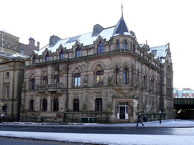
1010:== {{int:filedesc}} == {{Information |description={{en|1=Neville Hall and Wood Memorial Hall, Westgate Road Offices, library and lecture theatre built in 1870 by A.M. Dunn for the North of England Institute of Mining Engineers. The massive, Victorian Goth
57:
53:
47:
102:
70:
437:– You must give appropriate credit, provide a link to the license, and indicate if changes were made. You may do so in any reasonable manner, but not in any way that suggests the licensor endorses you or your use.
156:
Behind the railings on the front of the building, under a layer of concrete, lie the lower courses of the south face of
Hadrian's Wall, the line of which is now followed by Westgate Road, heading west from
1024:
146:
entrance. The building commemorates
Newcastle's former pre-eminence in coal mining and the coal trade. It houses the world's most significant mining library and related primary material
852:
701:
992:
987:
61:
42:
787:
653:
617:
319:
269:
938:
807:
1197:
354:
147:
1060:
This file contains additional information, probably added from the digital camera or scanner used to create or digitize it.
444:
552:
922:
893:
866:
815:
771:
742:
715:
601:
573:
560:
545:
830:
800:
673:
637:
518:
501:
341:
400:
1063:
If the file has been modified from its original state, some details may not fully reflect the modified file.
1020:
The following pages on the
English Knowledge (XXG) use this file (pages on other projects are not listed):
1224:
443:– If you remix, transform, or build upon the material, you must distribute your contributions under the
361:
on the
Geograph website for the photographer's contact details. The copyright on this image is owned by
1003:
397:
859:"}},"text\/plain":{"en":{"P7787":"157 degree"}}}}": -->
708:"}},"text\/plain":{"en":{"P7787":"157 degree"}}}}": -->
1260:
1029:
110:
214:
1341:
837:
822:
580:
198:
148:
http://www.twsitelines.info/Siteline.nsf/SMR/19C58E09CF01D0C5802576AF003E97E3?opendocument
325:
275:
1304:
1242:
1089:
366:
97:
1351:
1314:
1129:
135:
Neville Hall and Wood
Memorial Hall, Westgate Road - geograph.org.uk - 1690255.jpg
1270:
166:
1166:
1109:
309:
259:
1072:
187:
177:
1361:
1099:
346:
358:
1082:
960:
Click on a date/time to view the file as it appeared at that time.
1192:
Landscape mode (for landscape photos with the background in focus)
311:
261:
286:
236:
85:
1025:
North of
England Institute of Mining and Mechanical Engineers
296:
54° 58′ 09.9″ N, 1° 36′ 51″ W
246:
54° 58′ 10.9″ N, 1° 36′ 52″ W
485:
Add a one-line explanation of what this file represents
1047:
129:
109:
Commons is a freely licensed media file repository.
654:
Creative
Commons Attribution-ShareAlike 2.0 Generic
75:(1,024 × 768 pixels, file size: 209 KB, MIME type:
229:Neville Hall and Wood Memorial Hall, Westgate Road
210:Neville Hall and Wood Memorial Hall, Westgate Road
1265:Flash did not fire, compulsory flash suppression
454:https://creativecommons.org/licenses/by-sa/2.0
90:
460:Creative Commons Attribution-Share Alike 2.0
378:
8:
856:
705:
420:– to copy, distribute and transmit the work
151:Another photo from a similar angle is here
1065:
962:
481:
1040:The following other wikis use this file:
838:https://www.geograph.org.uk/photo/1690255
581:https://www.geograph.org.uk/profile/32242
1369:
1359:
1349:
1339:
1331:
1323:
1312:
1302:
1294:
1286:
1278:
1268:
1258:
1250:
1240:
1232:
1222:
1214:
1206:
1195:
1187:
1179:
1171:
1161:
1153:
1145:
1137:
1126:
1118:
1107:
1097:
1087:
1077:
1022:
936:
920:
880:
864:
785:
769:
729:
713:
687:
671:
651:
635:
615:
599:
532:
516:
499:
496:
477:
470:
289:
239:
318:View this and other nearby images on:
268:View this and other nearby images on:
1067:
7:
365:and is licensed for reuse under the
951:
401:Attribution-Share Alike 2.0 Generic
389:
384:
369:Attribution-ShareAlike 2.0 license.
1058:
490:
484:
375:
352:
139:
122:
68:
489:
1374:020281fa24fe73b519cfd40cb3270ef8
1120:Date and time of data generation
716:coordinates of the point of view
475:
431:Under the following conditions:
396:This file is licensed under the
388:
383:
377:
345:
324:
310:
302:
274:
260:
252:
89:
31:
21:
472:
140:
14:
788:file available on the internet
471:
353:This image was taken from the
26:
1:
867:coordinates of depicted place
36:
808:Geograph Britain and Ireland
546:object of statement has role
497:Items portrayed in this file
301:
251:
1208:Date and time of digitizing
731:54°58'10.88"N, 1°36'52.20"W
1391:
1325:Focal length in 35 mm film
1283:One-chip color area sensor
1044:Usage on www.wikidata.org
882:54°58'9.91"N, 1°36'51.12"W
445:same or compatible license
227:Andrew Curtis /
208:Andrew Curtis /
1181:File change date and time
952:
16:
816:geograph.org.uk image ID
474:
411:
96:This is a file from the
1288:Custom image processing
1237:3.61328125 APEX (f/3.5)
1009:
199:required by the license
183:
172:
165:
162:
132:
100:. Information from its
1216:Image compression mode
1211:11:02, 31 January 2010
1184:20:37, 2 February 2010
1123:11:02, 31 January 2010
939:Panasonic Lumix DMC-G1
359:this photograph's page
330:54.969420; -1.614200
280:54.969690; -1.614500
103:description page there
46:Size of this preview:
1234:Maximum land aperture
1147:Horizontal resolution
1173:Y and C positioning
1155:Vertical resolution
1094:1/160 sec (0.00625)
1069:Camera manufacturer
1030:User:Robertforsythe
988:03:08, 5 March 2011
426:– to adapt the work
52:Other resolutions:
1333:Scene capture type
1309:Auto white balance
561:author name string
62:1,024 × 768 pixels
1378:
1377:
1036:Global file usage
1013:
858:
707:
638:copyright license
483:
374:
373:
357:collection. See
335:
334:
285:
284:
234:
233:
202:
118:
117:
98:Wikimedia Commons
32:Global file usage
1382:
1189:Exposure Program
1066:
1000:
904:
903:
898:
840:
835:
831:described at URL
825:
820:
810:
805:
753:
752:
747:
602:copyright status
583:
578:
568:
565:
555:
550:
467:
464:
461:
458:
455:
447:as the original.
409:
398:Creative Commons
392:
391:
387:
386:
381:
380:
367:Creative Commons
355:Geograph project
349:
342:
331:
328:
314:
313:
307:
306:
305:
299:
298:
287:
281:
278:
264:
263:
257:
256:
255:
249:
248:
237:
196:
168:
144:
136:
130:
114:
93:
92:
86:
80:
78:
65:
58:640 × 480 pixels
54:320 × 240 pixels
48:800 × 600 pixels
1390:
1389:
1385:
1384:
1383:
1381:
1380:
1379:
1371:Unique image ID
1054:
1034:
1021:
1014:
1006:
998:
954:
953:
950:
949:
948:
947:
946:
945:
944:
943:
941:
929:
928:
927:
925:
914:
913:
912:
911:
910:
909:
908:
907:
906:
905:
901:
899:
896:
887:
886:
885:
883:
873:
872:
871:
869:
850:
849:
848:
847:
846:
845:
844:
843:
842:
841:
836:
833:
827:
826:
821:
818:
812:
811:
806:
803:
794:
793:
792:
790:
778:
777:
776:
774:
763:
762:
761:
760:
759:
758:
757:
756:
755:
754:
750:
748:
745:
736:
735:
734:
732:
722:
721:
720:
718:
699:
698:
697:
696:
695:
694:
693:
692:
690:
689:31 January 2010
680:
679:
678:
676:
665:
664:
663:
662:
661:
660:
659:
658:
656:
644:
643:
642:
640:
629:
628:
627:
626:
625:
624:
623:
622:
620:
608:
607:
606:
604:
593:
592:
591:
590:
589:
588:
587:
586:
585:
584:
579:
576:
570:
569:
566:
563:
557:
556:
551:
548:
539:
538:
537:
535:
525:
524:
523:
521:
510:
509:
508:
507:
506:
504:
488:
487:
486:
469:
468:
465:
462:
459:
456:
453:
452:
410:
407:
404:
393:
370:
340:
329:
303:
294:
293:
290:Object location
279:
253:
244:
243:
240:Camera location
235:
224:
217:
205:
178:geograph.org.uk
167:31 January 2010
158:
134:
127:
120:
119:
108:
107:
106:is shown below.
82:
76:
74:
67:
66:
51:
12:
11:
5:
1388:
1386:
1376:
1375:
1372:
1368:
1367:
1364:
1358:
1357:
1354:
1348:
1347:
1344:
1338:
1337:
1334:
1330:
1329:
1326:
1322:
1321:
1318:
1311:
1310:
1307:
1301:
1300:
1297:
1293:
1292:
1291:Normal process
1289:
1285:
1284:
1281:
1280:Sensing method
1277:
1276:
1273:
1267:
1266:
1263:
1257:
1256:
1253:
1249:
1248:
1245:
1239:
1238:
1235:
1231:
1230:
1227:
1221:
1220:
1217:
1213:
1212:
1209:
1205:
1204:
1201:
1194:
1193:
1190:
1186:
1185:
1182:
1178:
1177:
1174:
1170:
1169:
1164:
1160:
1159:
1156:
1152:
1151:
1148:
1144:
1143:
1140:
1136:
1135:
1132:
1125:
1124:
1121:
1117:
1116:
1113:
1106:
1105:
1102:
1096:
1095:
1092:
1086:
1085:
1080:
1076:
1075:
1070:
1057:
1053:
1052:
1051:
1050:
1038:
1037:
1033:
1032:
1027:
1019:
1018:
1017:
1012:
1011:
1008:
1004:
1001:
995:
990:
985:
981:
980:
977:
974:
971:
968:
965:
958:
957:
942:
937:
935:
934:
933:
932:
931:
930:
926:
921:
919:
918:
917:
916:
915:
892:
891:
890:
889:
888:
884:
881:
879:
878:
877:
876:
875:
874:
870:
865:
863:
862:
861:
860:
854:
829:
828:
814:
813:
799:
798:
797:
796:
795:
791:
786:
784:
783:
782:
781:
780:
779:
775:
772:source of file
770:
768:
767:
766:
765:
764:
741:
740:
739:
738:
737:
733:
730:
728:
727:
726:
725:
724:
723:
719:
714:
712:
711:
710:
709:
703:
691:
688:
686:
685:
684:
683:
682:
681:
677:
672:
670:
669:
668:
667:
666:
657:
652:
650:
649:
648:
647:
646:
645:
641:
636:
634:
633:
632:
631:
630:
621:
616:
614:
613:
612:
611:
610:
609:
605:
600:
598:
597:
596:
595:
594:
572:
571:
559:
558:
544:
543:
542:
541:
540:
536:
533:
531:
530:
529:
528:
527:
526:
522:
517:
515:
514:
513:
512:
511:
505:
500:
498:
495:
494:
493:
492:
491:
480:
479:
476:
473:
451:
450:
449:
448:
438:
429:
428:
427:
421:
414:You are free:
405:
395:
394:
376:
372:
371:
350:
339:
336:
333:
332:
322:
316:
291:
283:
282:
272:
266:
241:
232:
231:
225:
222:
219:
218:
213:
206:
203:
191:
190:
185:
181:
180:
174:
170:
169:
164:
160:
159:
137:
128:
126:
123:
121:
116:
115:
94:
84:
83:
45:
41:
40:
39:
34:
29:
24:
19:
13:
10:
9:
6:
4:
3:
2:
1387:
1373:
1370:
1365:
1363:
1360:
1355:
1353:
1350:
1345:
1343:
1340:
1335:
1332:
1327:
1324:
1319:
1316:
1313:
1308:
1306:
1305:White balance
1303:
1299:Auto exposure
1298:
1296:Exposure mode
1295:
1290:
1287:
1282:
1279:
1274:
1272:
1269:
1264:
1262:
1259:
1254:
1251:
1246:
1244:
1243:Metering mode
1241:
1236:
1233:
1228:
1226:
1225:Exposure bias
1223:
1218:
1215:
1210:
1207:
1202:
1199:
1196:
1191:
1188:
1183:
1180:
1175:
1172:
1168:
1165:
1163:Software used
1162:
1157:
1154:
1149:
1146:
1141:
1138:
1133:
1131:
1127:
1122:
1119:
1114:
1111:
1108:
1103:
1101:
1098:
1093:
1091:
1090:Exposure time
1088:
1084:
1081:
1078:
1074:
1071:
1068:
1064:
1061:
1055:
1049:
1046:
1045:
1043:
1042:
1041:
1035:
1031:
1028:
1026:
1023:
1015:
1007:
1002:
996:
994:
991:
989:
986:
983:
982:
978:
975:
972:
969:
966:
964:
963:
961:
955:
940:
924:
923:captured with
895:
868:
839:
832:
824:
817:
809:
802:
789:
773:
744:
717:
675:
655:
639:
619:
603:
582:
575:
567:Andrew Curtis
562:
554:
547:
520:
503:
457:CC BY-SA 2.0
446:
442:
439:
436:
433:
432:
430:
425:
422:
419:
416:
415:
413:
412:
408:Andrew Curtis
406:Attribution:
402:
399:
382:
368:
364:
363:Andrew Curtis
360:
356:
351:
348:
344:
343:
337:
327:
323:
321:
320:OpenStreetMap
317:
315:
297:
292:
288:
277:
273:
271:
270:OpenStreetMap
267:
265:
247:
242:
238:
230:
226:
221:
220:
216:
212: /
211:
207:
200:
195:
193:
192:
189:
188:Andrew Curtis
186:
182:
179:
175:
171:
161:
155:
154:
149:
143:
138:
131:
124:
112:
105:
104:
99:
95:
88:
87:
81:
72:
71:Original file
63:
59:
55:
49:
44:
38:
35:
33:
30:
28:
25:
23:
20:
18:
15:
1315:Digital zoom
1275:Uncalibrated
1252:Light source
1130:focal length
1079:Camera model
1062:
1059:
1039:
997:1,024 × 768
959:
956:File history
553:photographer
440:
434:
423:
417:
362:
300:
250:
228:
215:CC BY-SA 2.0
209:
150:
141:
111:You can help
101:
69:
22:File history
1271:Color space
1139:Orientation
1005:GeographBot
618:copyrighted
441:share alike
435:attribution
194:Attribution
133:Description
1352:Saturation
1167:Picasa 3.0
1016:File usage
973:Dimensions
534:some value
157:Newcastle.
77:image/jpeg
27:File usage
1362:Sharpness
1110:ISO speed
1073:Panasonic
970:Thumbnail
967:Date/Time
674:inception
338:Licensing
223:InfoField
204:InfoField
142:English:
1342:Contrast
1336:Standard
1176:Co-sited
1100:F-number
1056:Metadata
1048:Q7057517
999:(209 KB)
801:operator
478:Captions
424:to remix
418:to share
403:license.
37:Metadata
1255:Unknown
1247:Pattern
1200:version
1158:180 dpi
1150:180 dpi
984:current
979:Comment
894:heading
853:heading
823:1690255
743:heading
702:heading
519:creator
502:depicts
482:English
153:1111333
125:Summary
73:
1356:Normal
1112:rating
1083:DMC-G1
902:degree
857:degree
751:degree
706:degree
308:
258:
184:Author
173:Source
1328:28 mm
1317:ratio
1261:Flash
1134:14 mm
1128:Lens
1104:f/5.6
176:From
1366:Hard
1346:Hard
1203:2.21
1198:Exif
976:User
900:157
749:157
466:true
463:true
163:Date
17:File
1115:100
574:URL
897::
834::
819::
804::
746::
577::
564::
549::
60:|
56:|
50:.
1320:0
1229:0
1219:4
1142:0
201:)
197:(
113:.
79:)
64:.
Text is available under the Creative Commons Attribution-ShareAlike License. Additional terms may apply.

_heading:157.00&language=en)
_heading:157.00&language=en)
