43:
515:
692:
608:
649:
600:
622:
698:
553:
703:
487:
99:
1155:"}},"text\/plain":{"en":{"":"heading"}}},"{\"value\":{\"amount\":\"+0\",\"unit\":\"http:\\\/\\\/www.wikidata.org\\\/entity\\\/Q28390\"},\"type\":\"quantity\"}":{"text\/html":{"en":{"P7787":"0
476:
1357:
1151:
591:
761:– You must give appropriate credit, provide a link to the license, and indicate if changes were made. You may do so in any reasonable manner, but not in any way that suggests the licensor endorses you or your use.
525:
1152:
568:
1410:
73:
69:
65:
61:
57:
53:
47:
110:
82:
529:
1138:
1051:
1034:
1017:
1000:
983:
947:
615:
1356:
1351:
1498:
This file contains additional information, probably added from the digital camera or scanner used to create or digitize it.
1378:, Canada, with topographic bakground (embeded raster file). French version. Equirectangular projection, WGS84 datum *Standa
1068:
514:
768:
1222:
1193:
1166:
1122:
931:
905:
890:
875:
1272:
1256:
1088:
967:
848:
831:
564:
897:
1475:
1425:
730:
726:
722:
718:
714:
560:
1501:
If the file has been modified from its original state, some details may not fully reflect the modified file.
1388:
The following pages on the
English Knowledge (XXG) use this file (pages on other projects are not listed):
503:
1435:
767:– If you remix, transform, or build upon the material, you must distribute your contributions under the
1430:
654:
Copyleft: This work of art is free; you can redistribute it and/or modify it according to terms of the
1326:
1321:
337:
Topographie et relief : NASA Shuttle Radar
Topography Mission (SRTM3 v.2) (domaine public) ;
42:
710:
656:
268:
Topography and relief : NASA Shuttle Radar
Topography Mission (SRTM3 v.2) (public domain) ;
1159:"}},"text\/plain":{"en":{"P7787":"0 degree"}}}}": -->
882:
350:
281:
118:
1374:== {{int:filedesc}} == {{Information |Description={{Multilingual description |en=General map of
360:
291:
426:
197:
405:
382:
370:
313:
301:
200:, Canada, avec un fond topographique (fichier matriciel incorporé). Version en français.
156:
1367:
1337:
621:
496:
388:
344:
319:
275:
442:
376:
307:
1392:
1375:
640:
I, the copyright holder of this work, hereby publish it under the following licenses:
552:
265:
Shorelines : NASA Shuttle Radar
Topography Mission (SWBD) (public domain) ;
105:
334:
Côtes : NASA Shuttle Radar
Topography Mission (SWBD) (domaine public) ;
401:
238:
665:
643:
1465:
159:, Canada, with topographic bakground (embeded raster file). French version.
500:
605:
460:
437:
661:
524:
into your language, using any capable SVG editor, text editor or the
446:
509:
1294:
Click on a date/time to view the file as it appeared at that time.
607:
486:
1445:
1420:
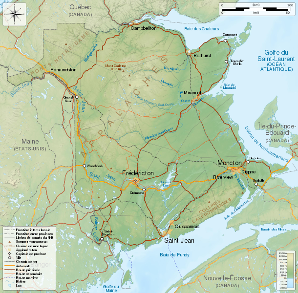
582:
93:
87:(SVG file, nominally 2,237 × 2,199 pixels, file size: 3.31 MB)
475:
1485:
1455:
592:
46° 24′ 00″ N, 66° 24′ 00″ W
1426:
Wikipédia:Atelier graphique/Cartes/Archives/décembre 2011
984:
Creative
Commons Attribution-ShareAlike 4.0 International
202:
Projection équirectangulaire, système géodétique WGS84.
815:
Add a one-line explanation of what this file represents
361:
Geogratis, Atlas de l'Amérique du Nord - Chemins de fer
1436:
Wikipédia:Atelier graphique/Cartes/Archives/avril 2020
1431:
Wikipédia:Atelier graphique/Cartes/Archives/mars 2013
1035:
Creative
Commons Attribution-ShareAlike 3.0 Unported
137:
117:
Commons is a freely licensed media file repository.
1052:
Creative
Commons Attribution-ShareAlike 2.5 Generic
1018:
Creative
Commons Attribution-ShareAlike 2.0 Generic
1001:
Creative
Commons Attribution-ShareAlike 1.0 Generic
571:to clean up, improve, create or translate as well.
660:. You will find a specimen of this license on the
340:Bathymétrie: NGDC ETOPO1 (domaine public) ;
351:Geogratis, Atlas de l'Amérique du Nord - Routes
883:https://commons.wikimedia.org/user:S%C3%A9mhur
778:https://creativecommons.org/licenses/by-sa/4.0
369:Compagnies de chemins de fer du Canada :
271:Bathymetry: NGDC ETOPO1 (public domain) ;
98:
784:Creative Commons Attribution-Share Alike 4.0
691:
375:Compagnies de chemins de fer du Maine :
8:
1156:
744:– to copy, distribute and transmit the work
359:Trajet des lignes de chemins de fer :
292:Geogratis, North American Atlas - Railroads
46:Size of this PNG preview of this SVG file:
1503:
1296:
811:
796:You may select the license of your choice.
547:
1403:The following other wikis use this file:
648:
559:This map was improved or created by the
213:Limites géographiques de la carte :
371:Association des chemins de fer du Canada
161:Equirectangular projection, WGS84 datum
1521:
1513:
1505:
1390:
1270:
1254:
1236:
1220:
1180:
1164:
1136:
1120:
1102:
1086:
1066:
1049:
1032:
1015:
998:
981:
965:
945:
929:
862:
846:
829:
826:
807:
800:
585:
282:Geogratis, North American Atlas - Roads
614:View this and other nearby images on:
7:
522:embedded text that can be translated
320:GeoBase, Canadian Geographical Names
300:Railways companies of Canada :
206:Méridien de référence : 66.4° O
143:New Brunswick topographic map-fr.svg
1285:
702:
697:
306:Railways companies of Maine :
1496:
820:
814:
795:
688:
670:http://artlibre.org/licence/lal/en
639:
558:
491:
480:
325:
314:GeoBase, Administrative Boundaries
255:
189:
148:
130:
80:
1462:Usage on incubator.wikimedia.org
819:
1167:coordinates of the point of view
805:
755:Under the following conditions:
709:This file is licensed under the
701:
696:
690:
647:
620:
606:
598:
551:
513:
485:
474:
383:GeoBase, Limites administratives
97:
31:
21:
802:
381:Limites administratives :
377:Gouvernement de l'État du Maine
276:GeoBase, National Hydro Network
209:Parallèle de référence: 46.4° N
14:
801:
345:GéoBase, Réseau hydro national
172:Geographic limits of the map:
26:
1:
1139:original creation by uploader
302:Railway association of Canada
36:
827:Items portrayed in this file
528:. For more information see:
512:
389:GeoBase, Toponymes canadiens
365:Ressources naturelles Canada
355:Ressources naturelles Canada
296:Ressources naturelles Canada
286:Ressources naturelles Canada
168:True scale parallel: 46.4° N
1482:Usage on zea.wikipedia.org
530:About translating SVG files
343:Cours d'eau et lacs :
1543:
1510:Carte du Nouveau-Brunswick
1472:Usage on kk.wikipedia.org
1452:Usage on id.wikipedia.org
1442:Usage on hu.wikipedia.org
1417:Usage on fr.wikipedia.org
1407:Usage on bn.wikipedia.org
769:same or compatible license
597:
519:
165:Standard meridian: 66.4° W
1286:
481:W3C-validity not checked.
326:
256:
249:
190:
149:
16:
1257:language of work or name
804:
735:
713:Attribution-Share Alike
274:Rivers and lakes :
104:This is a file from the
1373:
1352:21:18, 29 November 2011
1343:
550:
520:This SVG file contains
427:required by the license
414:
397:
244:
237:
234:
140:
108:. Information from its
662:Copyleft Attitude site
626:46.400000; -66.400000
308:Maine State Government
111:description page there
459:© Sémhur /
436:© Sémhur /
290:Railway lines :
1466:Wp/mic/Signigtewágig
217:Ouest : 69.2° O
74:2,237 × 2,199 pixels
70:2,083 × 2,048 pixels
66:1,042 × 1,024 pixels
750:– to adapt the work
567:(fr). You can
223:Nord : 48.3° N
52:Other resolutions:
1322:07:06, 23 May 2014
906:author name string
891:Wikimedia username
526:SVG Translate tool
312:Boundaries :
226:Sud : 44.5° N
220:Est : 63.6° O
196:Carte générale du
1530:
1529:
1421:Nouveau-Brunswick
1399:Global file usage
1381:
1158:
968:copyright license
813:
715:4.0 International
687:
686:
631:
630:
580:
579:
576:
575:
536:
535:
499:was created with
461:Wikimedia Commons
438:Wikimedia Commons
430:
387:Toponymes :
198:Nouveau-Brunswick
126:
125:
106:Wikimedia Commons
32:Global file usage
1534:
1504:
1364:
1334:
1204:
1203:
1198:
1182:46°24'N, 66°24'W
1104:29 November 2011
1069:Free Art License
932:copyright status
913:
910:
900:
895:
885:
880:
791:
788:
785:
782:
779:
771:as the original.
711:Creative Commons
705:
704:
700:
699:
694:
693:
683:
680:
677:
676:Free Art License
674:
671:
657:Free Art License
651:
650:
644:
627:
624:
610:
609:
603:
602:
601:
595:
594:
583:
555:
548:
517:
510:
489:
478:
447:Free Art License
424:
408:
331:
318:Toponyms :
261:
251:
240:
239:29 November 2011
195:
154:
144:
138:
122:
101:
100:
94:
88:
77:
62:781 × 768 pixels
58:488 × 480 pixels
54:244 × 240 pixels
48:610 × 600 pixels
1542:
1541:
1537:
1536:
1535:
1533:
1532:
1531:
1492:
1397:
1389:
1382:
1370:
1362:
1340:
1332:
1288:
1287:
1284:
1283:
1282:
1281:
1280:
1279:
1278:
1277:
1275:
1263:
1262:
1261:
1259:
1248:
1247:
1246:
1245:
1244:
1243:
1242:
1241:
1239:
1229:
1228:
1227:
1225:
1214:
1213:
1212:
1211:
1210:
1209:
1208:
1207:
1206:
1205:
1201:
1199:
1196:
1187:
1186:
1185:
1183:
1173:
1172:
1171:
1169:
1150:
1149:
1148:
1147:
1146:
1145:
1144:
1143:
1141:
1129:
1128:
1127:
1125:
1114:
1113:
1112:
1111:
1110:
1109:
1108:
1107:
1105:
1095:
1094:
1093:
1091:
1080:
1079:
1078:
1077:
1076:
1075:
1074:
1073:
1071:
1060:
1059:
1058:
1057:
1056:
1054:
1043:
1042:
1041:
1040:
1039:
1037:
1026:
1025:
1024:
1023:
1022:
1020:
1009:
1008:
1007:
1006:
1005:
1003:
992:
991:
990:
989:
988:
986:
974:
973:
972:
970:
959:
958:
957:
956:
955:
954:
953:
952:
950:
938:
937:
936:
934:
923:
922:
921:
920:
919:
918:
917:
916:
915:
914:
911:
908:
902:
901:
896:
893:
887:
886:
881:
878:
869:
868:
867:
865:
855:
854:
853:
851:
840:
839:
838:
837:
836:
834:
818:
817:
816:
799:
798:
797:
793:
792:
789:
786:
783:
780:
777:
776:
734:
706:
681:
678:
675:
672:
669:
642:
641:
636:
625:
599:
590:
589:
586:Camera location
581:
572:
544:
508:
507:
494:W3C-unspecified
483:
482:
470:
456:
449:
433:
406:
393:
392:
329:
324:
259:
230:
229:
193:
188:
155:General map of
152:
142:
135:
128:
127:
116:
115:
114:is shown below.
90:
86:
79:
78:
51:
12:
11:
5:
1540:
1538:
1528:
1527:
1524:
1520:
1519:
1516:
1512:
1511:
1508:
1495:
1491:
1490:
1489:
1488:
1480:
1479:
1478:
1470:
1469:
1468:
1460:
1459:
1458:
1450:
1449:
1448:
1440:
1439:
1438:
1433:
1428:
1423:
1415:
1414:
1413:
1411:নিউ ব্রান্সউইক
1401:
1400:
1396:
1395:
1387:
1386:
1385:
1380:
1379:
1372:
1368:
1365:
1361:2,237 × 2,199
1359:
1354:
1349:
1346:
1345:
1342:
1338:
1335:
1331:2,237 × 2,199
1329:
1324:
1319:
1315:
1314:
1311:
1308:
1305:
1302:
1299:
1292:
1291:
1276:
1271:
1269:
1268:
1267:
1266:
1265:
1264:
1260:
1255:
1253:
1252:
1251:
1250:
1249:
1240:
1237:
1235:
1234:
1233:
1232:
1231:
1230:
1226:
1221:
1219:
1218:
1217:
1216:
1215:
1192:
1191:
1190:
1189:
1188:
1184:
1181:
1179:
1178:
1177:
1176:
1175:
1174:
1170:
1165:
1163:
1162:
1161:
1160:
1154:
1142:
1137:
1135:
1134:
1133:
1132:
1131:
1130:
1126:
1123:source of file
1121:
1119:
1118:
1117:
1116:
1115:
1106:
1103:
1101:
1100:
1099:
1098:
1097:
1096:
1092:
1087:
1085:
1084:
1083:
1082:
1081:
1072:
1067:
1065:
1064:
1063:
1062:
1061:
1055:
1050:
1048:
1047:
1046:
1045:
1044:
1038:
1033:
1031:
1030:
1029:
1028:
1027:
1021:
1016:
1014:
1013:
1012:
1011:
1010:
1004:
999:
997:
996:
995:
994:
993:
987:
982:
980:
979:
978:
977:
976:
975:
971:
966:
964:
963:
962:
961:
960:
951:
946:
944:
943:
942:
941:
940:
939:
935:
930:
928:
927:
926:
925:
924:
904:
903:
889:
888:
874:
873:
872:
871:
870:
866:
863:
861:
860:
859:
858:
857:
856:
852:
847:
845:
844:
843:
842:
841:
835:
830:
828:
825:
824:
823:
822:
821:
810:
809:
806:
803:
794:
775:
774:
773:
772:
762:
753:
752:
751:
745:
738:You are free:
708:
707:
689:
685:
684:
666:on other sites
652:
638:
637:
635:
632:
629:
628:
618:
612:
587:
578:
577:
574:
573:
569:propose images
556:
545:
542:
538:
537:
534:
533:
518:
484:
473:
471:
468:
464:
463:
457:
454:
451:
450:
441:
434:
431:
419:
418:
416:
415:Other versions
412:
411:
399:
395:
394:
391:
385:
379:
373:
367:
357:
349:Routes :
347:
341:
338:
335:
327:
323:
322:
316:
310:
304:
298:
288:
278:
272:
269:
266:
257:
254:
246:
242:
241:
236:
232:
231:
228:
227:
224:
221:
218:
211:
210:
207:
191:
187:
186:
185:South: 44.5° N
183:
182:North: 48.3° N
180:
177:
170:
169:
166:
150:
147:
145:
136:
134:
131:
129:
124:
123:
102:
92:
91:
45:
41:
40:
39:
34:
29:
24:
19:
13:
10:
9:
6:
4:
3:
2:
1539:
1525:
1522:
1517:
1514:
1509:
1506:
1502:
1499:
1493:
1487:
1486:New Brunswick
1484:
1483:
1481:
1477:
1474:
1473:
1471:
1467:
1464:
1463:
1461:
1457:
1456:New Brunswick
1454:
1453:
1451:
1447:
1444:
1443:
1441:
1437:
1434:
1432:
1429:
1427:
1424:
1422:
1419:
1418:
1416:
1412:
1409:
1408:
1406:
1405:
1404:
1398:
1394:
1393:New Brunswick
1391:
1383:
1377:
1376:New Brunswick
1371:
1366:
1360:
1358:
1355:
1353:
1350:
1348:
1347:
1341:
1336:
1330:
1328:
1325:
1323:
1320:
1317:
1316:
1312:
1309:
1306:
1303:
1300:
1298:
1297:
1295:
1289:
1274:
1258:
1238:image/svg+xml
1224:
1195:
1168:
1140:
1124:
1090:
1070:
1053:
1036:
1019:
1002:
985:
969:
949:
933:
907:
899:
892:
884:
877:
850:
833:
781:CC BY-SA 4.0
770:
766:
763:
760:
757:
756:
754:
749:
746:
743:
740:
739:
737:
736:
732:
728:
724:
720:
716:
712:
695:
667:
663:
659:
658:
653:
646:
645:
633:
623:
619:
617:
616:OpenStreetMap
613:
611:
593:
588:
584:
570:
566:
562:
561:Wikigraphists
557:
554:
549:
546:
540:
539:
531:
527:
523:
516:
511:
505:
502:
498:
495:
488:
477:
472:
466:
465:
462:
458:
453:
452:
448:
444:
440: /
439:
435:
428:
423:
421:
420:
417:
413:
409:
403:
400:
396:
390:
386:
384:
380:
378:
374:
372:
368:
366:
362:
358:
356:
352:
348:
346:
342:
339:
336:
333:
332:
321:
317:
315:
311:
309:
305:
303:
299:
297:
293:
289:
287:
283:
280:Roads :
279:
277:
273:
270:
267:
264:
263:
262:
253:
247:
243:
233:
225:
222:
219:
216:
215:
214:
208:
205:
204:
203:
199:
184:
181:
179:East: 63.6° W
178:
176:West: 69.2° W
175:
174:
173:
167:
164:
163:
162:
158:
157:New Brunswick
146:
139:
132:
120:
113:
112:
107:
103:
96:
95:
89:
84:
83:Original file
75:
71:
67:
63:
59:
55:
49:
44:
38:
35:
33:
30:
28:
25:
23:
20:
18:
15:
1500:
1497:
1476:Нью-Брансуик
1446:Új-Brunswick
1402:
1293:
1290:File history
764:
758:
747:
741:
719:3.0 Unported
655:
596:
521:
497:vector image
493:
443:CC-BY-SA-4.0
364:
354:
295:
285:
248:
212:
201:
171:
160:
119:You can help
109:
81:
22:File history
1507:Short title
948:copyrighted
765:share alike
759:attribution
731:1.0 Generic
727:2.0 Generic
723:2.5 Generic
664:as well as
565:Graphic Lab
541:Graphic Lab
422:Attribution
141:Description
1384:File usage
1307:Dimensions
1223:media type
864:some value
504:…important
27:File usage
1526:2198.9099
1363:(3.31 MB)
1344:Valid SVG
1333:(3.31 MB)
1304:Thumbnail
1301:Date/Time
1089:inception
634:Licensing
543:InfoField
469:InfoField
455:InfoField
432:InfoField
1494:Metadata
808:Captions
748:to remix
742:to share
733:license.
501:Inkscape
328:Français
250:Own work
192:Français
37:Metadata
1518:2237.28
1318:current
1313:Comment
1194:heading
1153:heading
849:creator
832:depicts
812:English
563:of the
258:English
151:English
133:Summary
85:
1523:Height
1369:Sémhur
1339:Sémhur
1273:French
1202:degree
1157:degree
912:Sémhur
898:Sémhur
604:
490:
479:
402:Sémhur
398:Author
245:Source
1515:Width
679:false
492:This
445:, or
1310:User
790:true
787:true
729:and
682:true
407:talk
363:par
353:par
235:Date
17:File
876:URL
673:FAL
467:SVG
294:by
284:by
1200:0
1197::
909::
894::
879::
725:,
721:,
717:,
668:.
532:.
330::
260::
252:.
194::
153::
72:|
68:|
64:|
60:|
56:|
50:.
506:.
429:)
425:(
410:)
404:(
121:.
76:.
Text is available under the Creative Commons Attribution-ShareAlike License. Additional terms may apply.
