270:
225:
276:
281:
95:
43:
735:
339:– You must give appropriate credit, provide a link to the license, and indicate if changes were made. You may do so in any reasonable manner, but not in any way that suggests the licensor endorses you or your use.
752:{{Information |Description ={{en|1=Map of the Santa Ana River watershed in southern California, USA}} |Source =Topography from USGS, rest by me |Author =
843:
242:
942:
770:
813:
240:; with no Invariant Sections, no Front-Cover Texts, and no Back-Cover Texts. A copy of the license is included in the section entitled
232:
646:
629:
612:
595:
578:
561:
525:
906:
This file contains additional information, probably added from the digital camera or scanner used to create or digitize it.
346:
878:
868:
509:
481:
466:
453:
237:
795:
666:
545:
426:
409:
151:
785:
775:
488:
308:
304:
300:
296:
292:
909:
If the file has been modified from its original state, some details may not fully reflect the modified file.
766:
The following pages on the
English Knowledge (XXG) use this file (pages on other projects are not listed):
345:– If you remix, transform, or build upon the material, you must distribute your contributions under the
61:
288:
57:
53:
47:
848:
106:
114:
74:
790:
473:
219:
230:
Permission is granted to copy, distribute and/or modify this document under the terms of the
780:
156:
753:
745:
216:
I, the copyright holder of this work, hereby publish it under the following licenses:
101:
169:
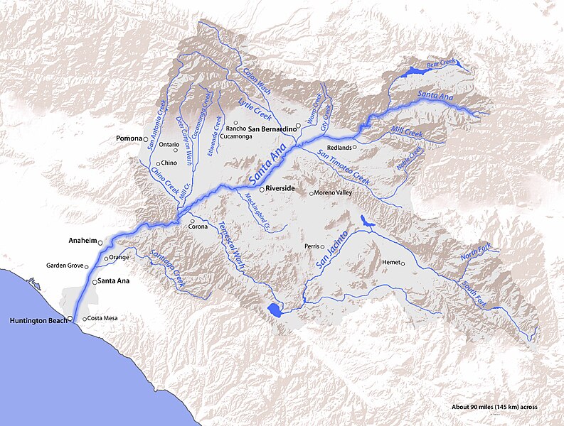
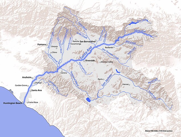
From the San
Bernardino, Santa Ana, and San Jacinto Mountains to the Pacific Ocean.
858:
957:
200:
182:
734:
729:
65:
42:
161:
160:(watershed) in Orange, Riverside, and San Bernardino Counties, Southern
702:
Click on a date/time to view the file as it appeared at that time.
833:
89:
823:
613:
Creative
Commons Attribution-ShareAlike 4.0 International
756:|Date =2011-05-20 |Permission = |other_ver
393:
Add a one-line explanation of what this file represents
893:
888:
630:
Creative
Commons Attribution-ShareAlike 3.0 Unported
562:
236:, Version 1.2 or any later version published by the
133:
113:
Commons is a freely licensed media file repository.
647:
Creative
Commons Attribution-ShareAlike 2.0 Generic
596:
Creative
Commons Attribution-ShareAlike 1.0 Generic
579:
Creative
Commons Attribution-ShareAlike 2.5 Generic
79:(1,230 × 930 pixels, file size: 570 KB, MIME type:
356:https://creativecommons.org/licenses/by-sa/4.0
94:
362:Creative Commons Attribution-Share Alike 4.0
269:
8:
474:https://commons.wikimedia.org/user:Shannon1
322:– to copy, distribute and transmit the work
911:
704:
389:
374:You may select the license of your choice.
806:The following other wikis use this file:
955:
947:
937:
929:
921:
913:
768:
680:
664:
644:
627:
610:
593:
576:
559:
543:
523:
507:
440:
424:
407:
404:
385:
378:
943:Adobe Photoshop Elements 6.0 Macintosh
771:Bear Creek (Santa Ana River tributary)
7:
248:http://www.gnu.org/copyleft/fdl.html
693:
280:
275:
904:
398:
392:
373:
266:
215:
143:
126:
72:
397:
859:Lijst van rivieren in Californië
383:
333:Under the following conditions:
287:This file is licensed under the
279:
274:
268:
224:
223:
192:Topography from USGS, rest by me
93:
31:
21:
380:
144:
14:
379:
254:GNU Free Documentation License
243:GNU Free Documentation License
233:GNU Free Documentation License
26:
1:
36:
405:Items portrayed in this file
820:Usage on ceb.wikipedia.org
810:Usage on arz.wikipedia.org
796:Temescal Valley, California
979:
885:Usage on www.wikidata.org
875:Usage on sr.wikipedia.org
865:Usage on ru.wikipedia.org
855:Usage on nl.wikipedia.org
840:Usage on ja.wikipedia.org
830:Usage on fr.wikipedia.org
347:same or compatible license
949:File change date and time
786:Rancho Temescal (Serrano)
694:
16:
776:Corona Founders Monument
382:
313:
291:Attribution-Share Alike
238:Free Software Foundation
100:This is a file from the
751:
196:
188:
181:
178:
136:
104:. Information from its
107:description page there
46:Size of this preview:
923:Horizontal resolution
931:Vertical resolution
328:– to adapt the work
52:Other resolutions:
952:16:23, 20 May 2011
834:Santa Ana (fleuve)
730:23:25, 20 May 2011
482:Wikimedia username
454:author name string
66:1,230 × 930 pixels
62:1,016 × 768 pixels
966:
965:
814:نهر تيميسكال كريك
802:Global file usage
791:San Timoteo Creek
759:
546:copyright license
391:
293:4.0 International
265:
264:
206:
205:
122:
121:
102:Wikimedia Commons
32:Global file usage
970:
912:
879:Санта Ана (река)
869:Санта-Ана (река)
742:
510:copyright status
491:
486:
476:
471:
461:
458:
369:
366:
363:
360:
357:
349:as the original.
289:Creative Commons
283:
282:
278:
277:
272:
271:
261:
258:
255:
252:
249:
227:
226:
220:
184:
148:
140:
134:
118:
97:
96:
90:
84:
82:
69:
58:635 × 480 pixels
54:318 × 240 pixels
48:793 × 600 pixels
978:
977:
973:
972:
971:
969:
968:
967:
900:
800:
781:Railroad Canyon
767:
760:
748:
740:
696:
695:
692:
691:
690:
689:
688:
687:
686:
685:
683:
673:
672:
671:
669:
658:
657:
656:
655:
654:
653:
652:
651:
649:
638:
637:
636:
635:
634:
632:
621:
620:
619:
618:
617:
615:
604:
603:
602:
601:
600:
598:
587:
586:
585:
584:
583:
581:
570:
569:
568:
567:
566:
564:
552:
551:
550:
548:
537:
536:
535:
534:
533:
532:
531:
530:
528:
516:
515:
514:
512:
501:
500:
499:
498:
497:
496:
495:
494:
493:
492:
487:
484:
478:
477:
472:
469:
463:
462:
459:
456:
447:
446:
445:
443:
433:
432:
431:
429:
418:
417:
416:
415:
414:
412:
396:
395:
394:
377:
376:
375:
371:
370:
367:
364:
361:
358:
355:
354:
312:
284:
259:
256:
253:
250:
247:
218:
217:
212:
207:
174:
152:Santa Ana River
138:
131:
124:
123:
112:
111:
110:is shown below.
86:
80:
78:
71:
70:
51:
12:
11:
5:
976:
974:
964:
963:
960:
954:
953:
950:
946:
945:
940:
936:
935:
932:
928:
927:
924:
920:
919:
916:
903:
899:
898:
897:
896:
891:
883:
882:
881:
873:
872:
871:
863:
862:
861:
853:
852:
851:
846:
844:サンバーナーディーノ・バレー
838:
837:
836:
828:
827:
826:
818:
817:
816:
804:
803:
799:
798:
793:
788:
783:
778:
773:
765:
764:
763:
758:
757:
750:
746:
743:
737:
732:
727:
723:
722:
719:
716:
713:
710:
707:
700:
699:
684:
681:
679:
678:
677:
676:
675:
674:
670:
665:
663:
662:
661:
660:
659:
650:
645:
643:
642:
641:
640:
639:
633:
628:
626:
625:
624:
623:
622:
616:
611:
609:
608:
607:
606:
605:
599:
594:
592:
591:
590:
589:
588:
582:
577:
575:
574:
573:
572:
571:
565:
560:
558:
557:
556:
555:
554:
553:
549:
544:
542:
541:
540:
539:
538:
529:
524:
522:
521:
520:
519:
518:
517:
513:
508:
506:
505:
504:
503:
502:
480:
479:
465:
464:
452:
451:
450:
449:
448:
444:
441:
439:
438:
437:
436:
435:
434:
430:
425:
423:
422:
421:
420:
419:
413:
408:
406:
403:
402:
401:
400:
399:
388:
387:
384:
381:
372:
353:
352:
351:
350:
340:
331:
330:
329:
323:
316:You are free:
286:
285:
267:
263:
262:
228:
214:
213:
211:
208:
204:
203:
198:
194:
193:
190:
186:
185:
180:
176:
175:
173:
172:
171:
170:
157:drainage basin
141:
132:
130:
127:
125:
120:
119:
98:
88:
87:
45:
41:
40:
39:
34:
29:
24:
19:
13:
10:
9:
6:
4:
3:
2:
975:
961:
959:
956:
951:
948:
944:
941:
939:Software used
938:
933:
930:
925:
922:
917:
914:
910:
907:
901:
895:
892:
890:
887:
886:
884:
880:
877:
876:
874:
870:
867:
866:
864:
860:
857:
856:
854:
850:
847:
845:
842:
841:
839:
835:
832:
831:
829:
825:
824:Temescal Wash
822:
821:
819:
815:
812:
811:
809:
808:
807:
801:
797:
794:
792:
789:
787:
784:
782:
779:
777:
774:
772:
769:
761:
755:
749:
744:
738:
736:
733:
731:
728:
725:
724:
720:
717:
714:
711:
708:
706:
705:
703:
697:
668:
648:
631:
614:
597:
580:
563:
547:
527:
511:
490:
483:
475:
468:
455:
428:
411:
359:CC BY-SA 4.0
348:
344:
341:
338:
335:
334:
332:
327:
324:
321:
318:
317:
315:
314:
310:
306:
302:
298:
294:
290:
273:
245:
244:
239:
235:
234:
229:
222:
221:
209:
202:
199:
195:
191:
187:
177:
168:
167:
166:
165:
163:
159:
158:
154:
153:
147:
142:
135:
128:
116:
109:
108:
103:
99:
92:
91:
85:
76:
75:Original file
67:
63:
59:
55:
49:
44:
38:
35:
33:
30:
28:
25:
23:
20:
18:
15:
908:
905:
805:
739:1,230 × 930
701:
698:File history
342:
336:
325:
319:
297:3.0 Unported
241:
231:
155:
150:
145:
115:You can help
105:
73:
22:File history
958:Color space
915:Orientation
682:20 May 2011
526:copyrighted
343:share alike
337:attribution
309:1.0 Generic
305:2.0 Generic
301:2.5 Generic
183:20 May 2011
149:Map of the
139:SAR Map.jpg
137:Description
762:File usage
715:Dimensions
442:some value
162:California
81:image/jpeg
27:File usage
712:Thumbnail
709:Date/Time
667:inception
210:Licensing
146:English:
902:Metadata
894:Q7698101
889:Q7284045
754:Shannon1
747:Shannon1
741:(570 KB)
489:Shannon1
460:Shannon1
386:Captions
326:to remix
320:to share
311:license.
201:Shannon1
37:Metadata
726:current
721:Comment
427:creator
410:depicts
390:English
129:Summary
77:
934:72 dpi
926:72 dpi
918:Normal
849:サンタアナ川
197:Author
189:Source
962:sRGB
718:User
368:true
365:true
307:and
260:true
257:true
251:GFDL
179:Date
17:File
467:URL
485::
470::
457::
303:,
299:,
295:,
164:.
64:|
60:|
56:|
50:.
246:.
117:.
83:)
68:.
Text is available under the Creative Commons Attribution-ShareAlike License. Additional terms may apply.
