43:
251:
212:
226:
257:
354:
262:
377:
103:
620:
387:
with reference to the URL in case of a website, to the ISBN/author/title in case of a printed work or ebook, or a description of where and how the file will be used in other cases. However, this is not a requirement for use.
669:
303:– You must give appropriate credit, provide a link to the license, and indicate if changes were made. You may do so in any reasonable manner, but not in any way that suggests the licensor endorses you or your use.
203:
69:
65:
61:
57:
53:
47:
114:
82:
565:
495:
459:
219:
682:
This file contains additional information, probably added from the digital camera or scanner used to create or digitize it.
619:
614:
310:
73:
42:
549:
515:
443:
479:
426:
651:
380:
710:
272:
685:
If the file has been modified from its original state, some details may not fully reflect the modified file.
647:
The following pages on the
English Knowledge (XXG) use this file (pages on other projects are not listed):
309:– If you remix, transform, or build upon the material, you must distribute your contributions under the
269:
122:
384:
630:
225:
353:
346:
186:
166:
109:
244:
I, the copyright holder of this work, hereby publish it under the following license:
363:
209:
157:
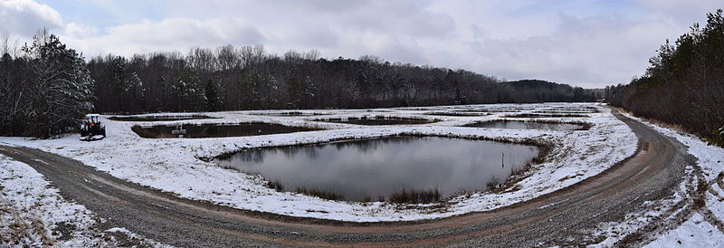
Snow surrounding ponds at the
University of Mississippi Field Station.
587:
Click on a date/time to view the file as it appeared at that time.
376:
211:
204:
34° 25′ 40.44″ N, 89° 23′ 23.28″ W
340:
508:
194:
97:
367:(or a similar license) for this file created by the author.
496:
Creative
Commons Attribution-ShareAlike 4.0 International
147:
Snow at the
University of Mississippi Field Station 1.JPG
87:(10,119 × 3,464 pixels, file size: 23.26 MB, MIME type:
410:
Add a one-line explanation of what this file represents
141:
121:
Commons is a freely licensed media file repository.
372:if you use this work outside of Wikimedia projects
320:https://creativecommons.org/licenses/by-sa/4.0
102:
326:Creative Commons Attribution-Share Alike 4.0
250:
8:
286:– to copy, distribute and transmit the work
687:
589:
406:
662:The following other wikis use this file:
273:Attribution-Share Alike 4.0 International
715:
705:
697:
689:
649:
563:
547:
529:
513:
493:
477:
457:
441:
424:
421:
402:
395:
197:
218:View this and other nearby images on:
7:
361:Permission is granted for use under
637:User created page with UploadWizard
578:
261:
256:
680:
415:
409:
247:
243:
151:
134:
80:
414:
670:משתמש:גופיקו/אוניברסיטת מיסיסיפי
516:coordinates of the point of view
400:
375:
352:
297:Under the following conditions:
268:This file is licensed under the
260:
255:
249:
224:
210:
101:
31:
21:
397:
152:
14:
396:
26:
1:
566:original creation by uploader
36:
422:Items portrayed in this file
360:
343:
370:Please let the author know
737:
666:Usage on he.wikipedia.org
531:34°25'40.4"N, 89°23'23.3"W
311:same or compatible license
717:File change date and time
652:University of Mississippi
579:
351:
338:
176:
16:
711:ArcSoft Panorama Maker 5
399:
277:
108:This is a file from the
720:15:46, 26 February 2015
636:
374:by sending an email to
182:
172:
167:26 February 2015, 11:48
165:
162:
144:
112:. Information from its
230:34.427900; -89.389800
115:description page there
46:Size of this preview:
691:Horizontal resolution
383:or leaving a message
74:10,119 × 3,464 pixels
615:21:22, 18 March 2015
699:Vertical resolution
292:– to adapt the work
52:Other resolutions:
70:2,560 × 876 pixels
66:1,280 × 438 pixels
62:1,024 × 351 pixels
724:
723:
658:Global file usage
640:
480:copyright license
408:
394:
393:
385:on this talk page
235:
234:
192:
191:
130:
129:
110:Wikimedia Commons
32:Global file usage
728:
688:
627:
444:copyright status
379:
356:
344:File created by
341:
333:
330:
327:
324:
321:
313:as the original.
270:Creative Commons
264:
263:
259:
258:
253:
252:
231:
228:
214:
213:
207:
206:
195:
178:
168:
156:
148:
142:
126:
105:
104:
98:
92:
90:
77:
58:640 × 219 pixels
54:320 × 110 pixels
48:800 × 274 pixels
736:
735:
731:
730:
729:
727:
726:
725:
676:
656:
648:
641:
633:
625:
624:10,119 × 3,464
581:
580:
577:
576:
575:
574:
573:
572:
571:
570:
568:
556:
555:
554:
552:
541:
540:
539:
538:
537:
536:
535:
534:
532:
522:
521:
520:
518:
507:
506:
505:
504:
503:
502:
501:
500:
498:
486:
485:
484:
482:
471:
470:
469:
468:
467:
466:
465:
464:
462:
450:
449:
448:
446:
435:
434:
433:
432:
431:
429:
413:
412:
411:
336:
335:
334:
331:
328:
325:
322:
319:
318:
276:
265:
246:
245:
240:
229:
202:
201:
198:Camera location
193:
158:
146:
139:
132:
131:
120:
119:
118:is shown below.
94:
88:
86:
79:
78:
51:
12:
11:
5:
734:
732:
722:
721:
718:
714:
713:
708:
704:
703:
700:
696:
695:
692:
679:
675:
674:
673:
672:
660:
659:
655:
654:
646:
645:
644:
639:
638:
635:
631:
628:
622:
617:
612:
608:
607:
604:
601:
598:
595:
592:
585:
584:
569:
564:
562:
561:
560:
559:
558:
557:
553:
550:source of file
548:
546:
545:
544:
543:
542:
533:
530:
528:
527:
526:
525:
524:
523:
519:
514:
512:
511:
510:
509:
499:
494:
492:
491:
490:
489:
488:
487:
483:
478:
476:
475:
474:
473:
472:
463:
458:
456:
455:
454:
453:
452:
451:
447:
442:
440:
439:
438:
437:
436:
430:
425:
423:
420:
419:
418:
417:
416:
405:
404:
401:
398:
392:
391:
358:
357:
350:
317:
316:
315:
314:
304:
295:
294:
293:
287:
280:You are free:
267:
266:
248:
242:
241:
239:
236:
233:
232:
222:
216:
199:
190:
189:
184:
180:
179:
174:
170:
169:
164:
160:
159:
149:
140:
138:
135:
133:
128:
127:
106:
96:
95:
45:
41:
40:
39:
34:
29:
24:
19:
13:
10:
9:
6:
4:
3:
2:
733:
719:
716:
712:
709:
707:Software used
706:
701:
698:
693:
690:
686:
683:
677:
671:
668:
667:
665:
664:
663:
657:
653:
650:
642:
634:
629:
623:
621:
618:
616:
613:
610:
609:
605:
602:
599:
596:
593:
591:
590:
588:
582:
567:
551:
517:
497:
481:
461:
445:
428:
390:
389:
386:
382:
378:
373:
368:
366:
365:
359:
355:
349:
348:
342:
339:
323:CC BY-SA 4.0
312:
308:
305:
302:
299:
298:
296:
291:
288:
285:
282:
281:
279:
278:
274:
271:
254:
237:
227:
223:
221:
220:OpenStreetMap
217:
215:
205:
200:
196:
188:
185:
181:
175:
171:
161:
155:
150:
143:
136:
124:
117:
116:
111:
107:
100:
99:
93:
84:
83:Original file
75:
71:
67:
63:
59:
55:
49:
44:
38:
35:
33:
30:
28:
25:
23:
20:
18:
15:
684:
681:
661:
586:
583:File history
371:
369:
364:CC BY-SA 4.0
362:
345:
337:
306:
300:
289:
283:
153:
123:You can help
113:
81:
22:File history
632:Fredlyfish4
460:copyrighted
381:Fredlyfish4
347:Fredlyfish4
307:share alike
301:attribution
187:Fredlyfish4
145:Description
643:File usage
626:(23.26 MB)
600:Dimensions
89:image/jpeg
27:File usage
597:Thumbnail
594:Date/Time
238:Licensing
154:English:
678:Metadata
403:Captions
290:to remix
284:to share
275:license.
177:Own work
37:Metadata
702:300 dpi
694:300 dpi
611:current
606:Comment
427:depicts
407:English
137:Summary
85:
208:
183:Author
173:Source
603:User
332:true
329:true
163:Date
17:File
72:|
68:|
64:|
60:|
56:|
50:.
125:.
91:)
76:.
Text is available under the Creative Commons Attribution-ShareAlike License. Additional terms may apply.
