257:
190:
182:
204:
225:
263:
268:
72:
582:"}},"text\/plain":{"en":{"":"heading"}}},"{\"value\":{\"amount\":\"+0\",\"unit\":\"http:\\\/\\\/www.wikidata.org\\\/entity\\\/Q28390\"},\"type\":\"quantity\"}":{"text\/html":{"en":{"P7787":"0
578:
788:{{Information |Description={{en|1=South Hiendley Almshouses This is the front view of the Almshouses looking though the arch to the chapel.}} |Source=http://www.geograph.org.uk/photo/575352 |Author=J Parkin |Date=2007-10-04 |Permission= |other_versions= }
315:– You must give appropriate credit, provide a link to the license, and indicate if changes were made. You may do so in any reasonable manner, but not in any way that suggests the licensor endorses you or your use.
173:
43:
812:
579:
83:
51:
802:
665:
531:
495:
197:
685:
232:
853:
This file contains additional information, probably added from the digital camera or scanner used to create or digitize it.
322:
445:
708:
649:
620:
593:
479:
453:
438:
423:
693:
678:
551:
515:
396:
379:
219:
830:
278:
856:
If the file has been modified from its original state, some details may not fully reflect the modified file.
798:
The following pages on the
English Knowledge (XXG) use this file (pages on other projects are not listed):
126:
South
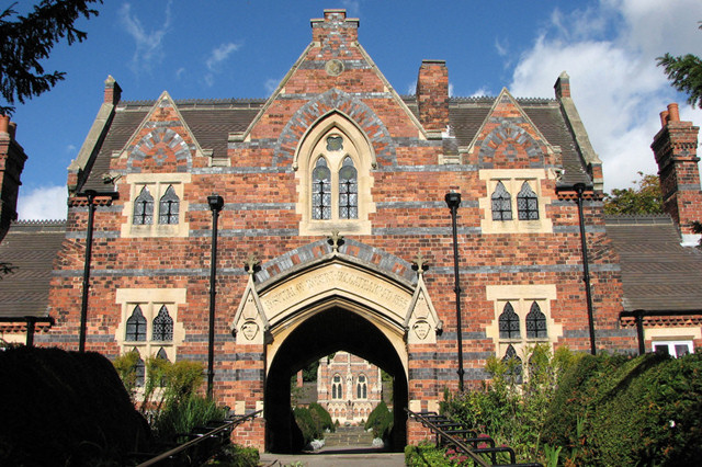
Hiendley Almshouses This is the front view of the Almshouses looking though the arch to the chapel.
321:– If you remix, transform, or build upon the material, you must distribute your contributions under the
239:
on the
Geograph website for the photographer's contact details. The copyright on this image is owned by
275:
586:"}},"text\/plain":{"en":{"P7787":"0 degree"}}}}": -->
770:
765:
91:
42:
430:
715:
700:
807:
781:
203:
244:
78:
187:
135:
156:
146:
224:
236:
738:
Click on a date/time to view the file as it appeared at that time.
189:
174:
53° 36′ 29.41″ N, 1° 22′ 46.91″ W
164:
66:
840:
363:
Add a one-line explanation of what this file represents
813:
User:Skinsmoke/Sandbox/Civil parishes/West
Yorkshire
110:
90:
Commons is a freely licensed media file repository.
532:
Creative
Commons Attribution-ShareAlike 2.0 Generic
56:(640 × 426 pixels, file size: 148 KB, MIME type:
332:https://creativecommons.org/licenses/by-sa/2.0
71:
338:Creative Commons Attribution-Share Alike 2.0
256:
8:
583:
298:– to copy, distribute and transmit the work
858:
740:
359:
823:The following other wikis use this file:
431:https://www.geograph.org.uk/profile/17965
701:https://www.geograph.org.uk/photo/575352
860:
800:
663:
647:
607:
591:
565:
549:
529:
513:
493:
477:
410:
394:
377:
374:
355:
348:
167:
196:View this and other nearby images on:
7:
243:and is licensed for reuse under the
729:
279:Attribution-Share Alike 2.0 Generic
267:
262:
247:Attribution-ShareAlike 2.0 license.
851:
368:
362:
253:
230:
120:
103:
49:
367:
803:Civil parishes in West Yorkshire
594:coordinates of the point of view
353:
309:Under the following conditions:
274:This file is licensed under the
266:
261:
255:
223:
202:
188:
180:
70:
31:
21:
350:
121:
116:South Hiendley - Almshouses.jpg
52:South_Hiendley_-_Almshouses.jpg
46:No higher resolution available.
14:
666:file available on the internet
349:
231:This image was taken from the
26:
1:
609:53°36'29.408"N, 1°22'46.906"W
36:
686:Geograph Britain and Ireland
439:object of statement has role
375:Items portrayed in this file
882:
837:Usage on fr.wikipedia.org
827:Usage on fa.wikipedia.org
323:same or compatible license
179:
730:
16:
766:13:57, 12 September 2009
709:geograph.org.uk image ID
352:
289:
77:This is a file from the
787:
152:
141:
134:
131:
113:
81:. Information from its
237:this photograph's page
208:53.608169; -1.379696
84:description page there
304:– to adapt the work
454:author name string
869:
868:
819:Global file usage
791:
585:
516:copyright license
361:
252:
251:
235:collection. See
213:
212:
162:
161:
99:
98:
79:Wikimedia Commons
32:Global file usage
873:
859:
778:
718:
713:
703:
698:
694:described at URL
688:
683:
631:
630:
625:
480:copyright status
461:
458:
448:
443:
433:
428:
345:
342:
339:
336:
333:
325:as the original.
287:
276:Creative Commons
270:
269:
265:
264:
259:
258:
245:Creative Commons
233:Geograph project
227:
220:
209:
206:
192:
191:
185:
184:
183:
177:
176:
165:
137:
125:
117:
111:
95:
74:
73:
67:
61:
59:
881:
880:
876:
875:
874:
872:
871:
870:
847:
817:
799:
792:
784:
776:
732:
731:
728:
727:
726:
725:
724:
723:
722:
721:
720:
719:
714:
711:
705:
704:
699:
696:
690:
689:
684:
681:
672:
671:
670:
668:
656:
655:
654:
652:
641:
640:
639:
638:
637:
636:
635:
634:
633:
632:
628:
626:
623:
614:
613:
612:
610:
600:
599:
598:
596:
577:
576:
575:
574:
573:
572:
571:
570:
568:
558:
557:
556:
554:
543:
542:
541:
540:
539:
538:
537:
536:
534:
522:
521:
520:
518:
507:
506:
505:
504:
503:
502:
501:
500:
498:
486:
485:
484:
482:
471:
470:
469:
468:
467:
466:
465:
464:
463:
462:
459:
456:
450:
449:
444:
441:
435:
434:
429:
426:
417:
416:
415:
413:
403:
402:
401:
399:
388:
387:
386:
385:
384:
382:
366:
365:
364:
347:
346:
343:
340:
337:
334:
331:
330:
288:
285:
282:
271:
248:
218:
207:
181:
172:
171:
168:Camera location
163:
147:geograph.org.uk
127:
115:
108:
101:
100:
89:
88:
87:is shown below.
63:
57:
55:
48:
47:
12:
11:
5:
879:
877:
867:
866:
863:
850:
846:
845:
844:
843:
841:South Hiendley
835:
834:
833:
821:
820:
816:
815:
810:
808:South Hiendley
805:
797:
796:
795:
790:
789:
786:
782:
779:
773:
768:
763:
759:
758:
755:
752:
749:
746:
743:
736:
735:
707:
706:
692:
691:
677:
676:
675:
674:
673:
669:
664:
662:
661:
660:
659:
658:
657:
653:
650:source of file
648:
646:
645:
644:
643:
642:
619:
618:
617:
616:
615:
611:
608:
606:
605:
604:
603:
602:
601:
597:
592:
590:
589:
588:
587:
581:
569:
567:4 October 2007
566:
564:
563:
562:
561:
560:
559:
555:
550:
548:
547:
546:
545:
544:
535:
530:
528:
527:
526:
525:
524:
523:
519:
514:
512:
511:
510:
509:
508:
499:
494:
492:
491:
490:
489:
488:
487:
483:
478:
476:
475:
474:
473:
472:
452:
451:
437:
436:
422:
421:
420:
419:
418:
414:
411:
409:
408:
407:
406:
405:
404:
400:
395:
393:
392:
391:
390:
389:
383:
378:
376:
373:
372:
371:
370:
369:
358:
357:
354:
351:
329:
328:
327:
326:
316:
307:
306:
305:
299:
292:You are free:
283:
273:
272:
254:
250:
249:
228:
217:
214:
211:
210:
200:
194:
169:
160:
159:
154:
150:
149:
143:
139:
138:
136:4 October 2007
133:
129:
128:
118:
109:
107:
104:
102:
97:
96:
75:
65:
64:
45:
41:
40:
39:
34:
29:
24:
19:
13:
10:
9:
6:
4:
3:
2:
878:
864:
861:
857:
854:
848:
842:
839:
838:
836:
832:
829:
828:
826:
825:
824:
818:
814:
811:
809:
806:
804:
801:
793:
785:
780:
774:
772:
769:
767:
764:
761:
760:
756:
753:
750:
747:
744:
742:
741:
739:
733:
717:
710:
702:
695:
687:
680:
667:
651:
622:
595:
553:
533:
517:
497:
481:
455:
447:
440:
432:
425:
398:
381:
335:CC BY-SA 2.0
324:
320:
317:
314:
311:
310:
308:
303:
300:
297:
294:
293:
291:
290:
284:Attribution:
280:
277:
260:
246:
242:
238:
234:
229:
226:
222:
221:
215:
205:
201:
199:
198:OpenStreetMap
195:
193:
175:
170:
166:
158:
155:
151:
148:
144:
140:
130:
124:
119:
112:
105:
93:
86:
85:
80:
76:
69:
68:
62:
53:
44:
38:
35:
33:
30:
28:
25:
23:
20:
18:
15:
855:
852:
831:ساوت هایندلی
822:
737:
734:File history
446:photographer
318:
312:
301:
295:
240:
178:
122:
92:You can help
82:
50:
22:File history
496:copyrighted
319:share alike
313:attribution
114:Description
862:_error
794:File usage
775:640 × 426
751:Dimensions
412:some value
58:image/jpeg
27:File usage
783:Skinsmoke
748:Thumbnail
745:Date/Time
552:inception
216:Licensing
123:English:
849:Metadata
777:(148 KB)
679:operator
460:J Parkin
356:Captions
302:to remix
296:to share
286:J Parkin
281:license.
241:J Parkin
157:J Parkin
37:Metadata
762:current
757:Comment
621:heading
580:heading
397:creator
380:depicts
360:English
106:Summary
54:
716:575352
629:degree
584:degree
186:
153:Author
142:Source
145:From
754:User
344:true
341:true
132:Date
17:File
424:URL
712::
697::
682::
627:0
624::
457::
442::
427::
865:0
94:.
60:)
Text is available under the Creative Commons Attribution-ShareAlike License. Additional terms may apply.
