43:
273:
238:
103:
435:
258:
UN maps are, in principle, open source material and you can use them in your work or for making your own map. UN requests however that you delete the UN name, logo and reference number upon any modification to the map. Content of your map will be your responsibility. You can state in your
69:
65:
61:
57:
47:
53:
114:
82:
471:
529:
476:
260:
184:
380:
542:
This file contains additional information, probably added from the digital camera or scanner used to create or digitize it.
364:
330:
313:
259:
publication, if you wish, something like: based on UN map … (map name, map number, revision number and date). See:
434:
429:
73:
42:
494:
545:
If the file has been modified from its original state, some details may not fully reflect the modified file.
462:
The following pages on the
English Knowledge (XXG) use this file (pages on other projects are not listed):
519:
252:
Unless stated otherwise, UN maps are to be considered in the public domain. This applies worldwide.
161:
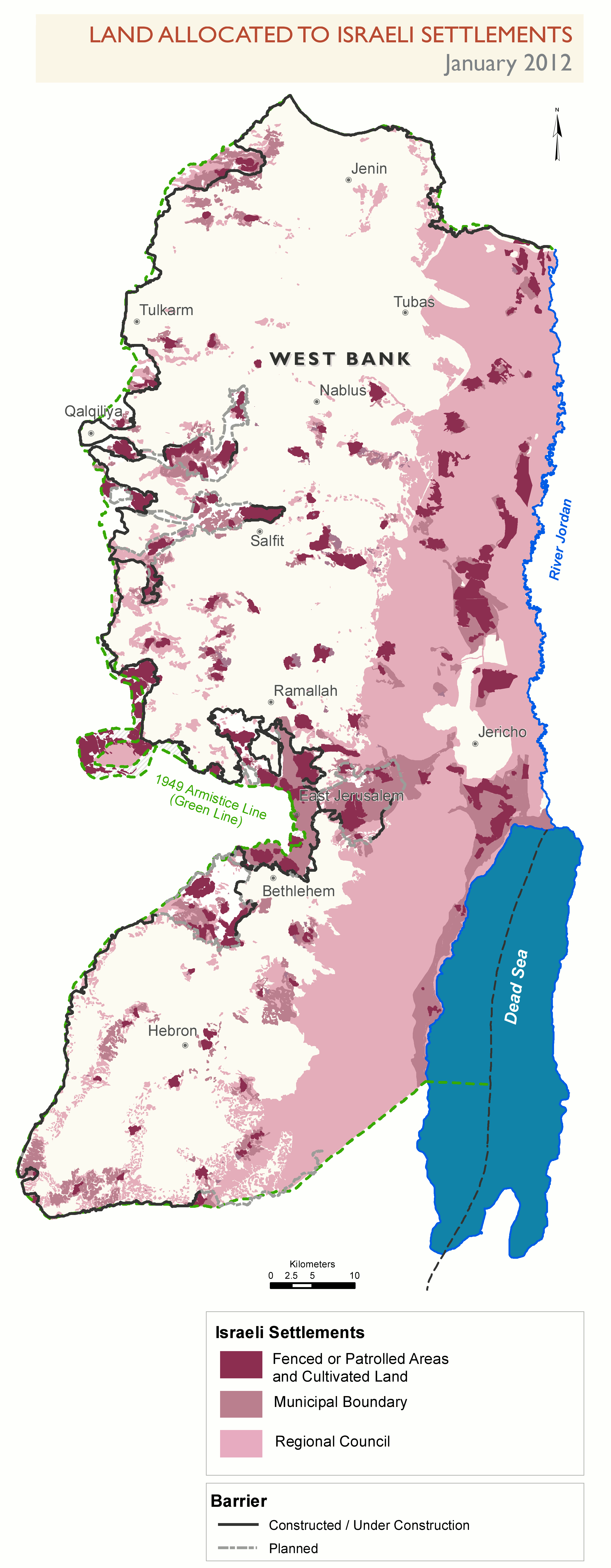
allocated to the
Israeli settlements, as of January 2012. No access for Palestinians, in principle.
466:
185:
http://www.ochaopt.org/documents/ocha_opt_land_allocated_for_settlements_January_2012_english.pdf
122:
445:
109:
509:
245:
199:
264:
188:
272:
170:
158:
255:
Some UN maps have special copyrights, as indicated on the map itself.
402:
Click on a date/time to view the file as it appeared at that time.
232:
97:
520:
Relazioni bilaterali tra
Israele e Stati Uniti d'America
495:
Resolució 2334 del
Consell de Seguretat de les Nacions Unides
271:
504:
297:
Add a one-line explanation of what this file represents
87:(2,629 × 6,738 pixels, file size: 318 KB, MIME type:
141:
121:
Commons is a freely licensed media file repository.
472:United Nations Security Council Resolution 2334
102:
8:
265:Geospatial, location data for a better world
147:Settlements allocated land, January-2012.png
547:
404:
293:
212:
487:The following other wikis use this file:
565:
557:
549:
464:
378:
362:
344:
328:
311:
308:
289:
282:
237:
7:
477:User:Falcaorib/Israel and Palestine
452:User created page with UploadWizard
393:
243:This image is a map derived from a
540:
302:
296:
151:
134:
80:
510:Guerre Israël-Hamas (depuis 2023)
301:
287:
236:
101:
31:
21:
284:
152:
14:
283:
261:Geospatial Information Section
26:
1:
381:original creation by uploader
36:
309:Items portrayed in this file
587:
526:Usage on zh.wikipedia.org
516:Usage on it.wikipedia.org
501:Usage on fr.wikipedia.org
491:Usage on ca.wikipedia.org
567:File change date and time
394:
180:
16:
286:
108:This is a file from the
570:16:52, 14 November 2013
451:
430:17:00, 14 November 2013
195:
176:
169:
166:
157:Parts of Area C of the
144:
112:. Information from its
276:
115:description page there
46:Size of this preview:
551:Horizontal resolution
275:
74:2,629 × 6,738 pixels
559:Vertical resolution
52:Other resolutions:
467:Israeli settlement
277:
189:OCHAoPt Map Centre
70:799 × 2,048 pixels
66:399 × 1,024 pixels
574:
573:
483:Global file usage
455:
295:
281:
280:
231:
230:
205:
204:
130:
129:
110:Wikimedia Commons
32:Global file usage
578:
548:
530:联合国安全理事会第2334号决议
442:
346:14 November 2013
240:
239:
233:
227:
224:
221:
218:
213:
183:. Adaptation of
182:
172:
171:14 November 2013
156:
148:
142:
126:
105:
104:
98:
92:
90:
77:
62:299 × 768 pixels
58:187 × 480 pixels
48:234 × 600 pixels
586:
585:
581:
580:
579:
577:
576:
575:
536:
481:
463:
456:
448:
440:
396:
395:
392:
391:
390:
389:
388:
387:
386:
385:
383:
371:
370:
369:
367:
356:
355:
354:
353:
352:
351:
350:
349:
347:
337:
336:
335:
333:
322:
321:
320:
319:
318:
316:
300:
299:
298:
225:
222:
219:
216:
211:
206:
162:
146:
139:
132:
131:
120:
119:
118:is shown below.
94:
88:
86:
79:
78:
54:93 × 240 pixels
51:
12:
11:
5:
584:
582:
572:
571:
568:
564:
563:
560:
556:
555:
552:
539:
535:
534:
533:
532:
524:
523:
522:
514:
513:
512:
507:
499:
498:
497:
485:
484:
480:
479:
474:
469:
461:
460:
459:
454:
453:
450:
446:
443:
439:2,629 × 6,738
437:
432:
427:
423:
422:
419:
416:
413:
410:
407:
400:
399:
384:
379:
377:
376:
375:
374:
373:
372:
368:
365:source of file
363:
361:
360:
359:
358:
357:
348:
345:
343:
342:
341:
340:
339:
338:
334:
329:
327:
326:
325:
324:
323:
317:
312:
310:
307:
306:
305:
304:
303:
292:
291:
288:
285:
279:
278:
269:
246:United Nations
241:
229:
228:
210:
207:
203:
202:
197:
193:
192:
178:
174:
173:
168:
164:
163:
149:
140:
138:
135:
133:
128:
127:
106:
96:
95:
45:
41:
40:
39:
34:
29:
24:
19:
13:
10:
9:
6:
4:
3:
2:
583:
569:
566:
561:
558:
553:
550:
546:
543:
537:
531:
528:
527:
525:
521:
518:
517:
515:
511:
508:
506:
503:
502:
500:
496:
493:
492:
490:
489:
488:
482:
478:
475:
473:
470:
468:
465:
457:
449:
444:
438:
436:
433:
431:
428:
425:
424:
420:
417:
414:
411:
408:
406:
405:
403:
397:
382:
366:
332:
315:
274:
270:
268:
266:
262:
256:
254:
253:
248:
247:
242:
235:
234:
220:Public domain
217:Public domain
215:
214:
208:
201:
198:
194:
190:
186:
179:
175:
165:
160:
155:
150:
143:
136:
124:
117:
116:
111:
107:
100:
99:
93:
84:
83:Original file
75:
71:
67:
63:
59:
55:
49:
44:
38:
35:
33:
30:
28:
25:
23:
20:
18:
15:
544:
541:
486:
401:
398:File history
257:
251:
250:
244:
153:
123:You can help
113:
81:
22:File history
505:Cisjordanie
145:Description
562:236.22 dpc
554:236.22 dpc
458:File usage
415:Dimensions
27:File usage
447:Wickey-nl
412:Thumbnail
409:Date/Time
331:inception
209:Licensing
200:Wickey-nl
159:West Bank
154:English:
89:image/png
538:Metadata
441:(318 KB)
290:Captions
181:Own work
37:Metadata
426:current
421:Comment
314:depicts
294:English
263:. And:
137:Summary
85:
196:Author
177:Source
249:map.
226:false
223:false
418:User
167:Date
17:File
187:on
267:.
72:|
68:|
64:|
60:|
56:|
50:.
191:.
125:.
91:)
76:.
Text is available under the Creative Commons Attribution-ShareAlike License. Additional terms may apply.
