161:", which should typically be linked as an accompaniment to these maps to (in their words) "minimize the numerous 'complaints' or comments by users who feel it necessary to point out how the Clerk's Office is 'wrong' about a certain section of town." In particular, "About Maps" says that the atlas "is designed for subject indexing of legislation, photographs, and other documents in the City Clerk's Office and Seattle Municipal Archives" and "is not designed or intended as an 'official' City of Seattle neighborhood map. There are many different ideas of what neighborhood districts exist in Seattle and what their names are…"
444:
43:
380:
289:
322:
261:
95:
643:
443:
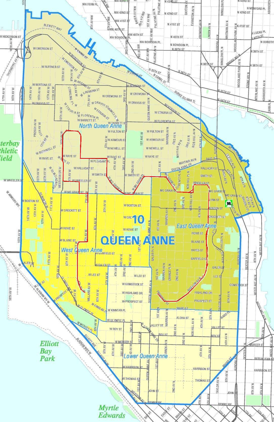
660:==Summary== {{Information |Description=Unofficial map of the Queen Anne neighborhood. Queen Anne Boulevard marked in red. {{Seattle Neighborhood Atlas disclaimer}} |Source=Image from the [http://clerk.ci.seattle.wa.us/public/nmaps/html/NN-1200L.htm Seattl
277:
While these maps are used by the clerk's office as a way to increase consistency in their own use of geographic names, the atlas is "not designed or intended as an 'official' City of
Seattle neighborhood map, and has no official status." (See
384:
402:
The
Wikimedia Foundation has received an e-mail confirming that the copyright holder has approved publication under the terms mentioned on this page. This correspondence has been
157:, which the Seattle Clerk's Office has placed in the public domain (as confirmed by OTRS ticket 2008033110016048) contains some general commentary on the maps, "
61:
57:
53:
47:
106:
418:
74:
588:
427:
144:
Unofficial map of the Queen Anne neighborhood. Queen Anne
Boulevard marked in red. The boulevard has status as a Seattle City landmark.
396:
206:
552:
516:
705:
This file contains additional information, probably added from the digital camera or scanner used to create or digitize it.
572:
500:
273:
because it is part of the
Seattle Neighborhood Atlas, which the Seattle Clerk's Office has placed in the public domain.
434:
222:
536:
483:
413:
409:
674:
400:, you do not need to request permission as long as you follow any licensing requirements mentioned on this page.
708:
If the file has been modified from its original state, some details may not fully reflect the modified file.
189:; if that is considered "creative", then he hereby releases all rights to this image into the public domain.
642:
637:
65:
42:
670:
The following pages on the
English Knowledge use this file (pages on other projects are not listed):
435:
https://ticket.wikimedia.org/otrs/index.pl?Action=AgentTicketZoom&TicketNumber=2008033110016048
114:
182:
391:
279:
158:
330:
269:
101:
692:
653:
335:
146:
288:
186:
426:
If you have questions about the archived correspondence, please use the
173:
Retrieved from
Seattle City Clerk's Neighborhood Map Atlas July 23, 2008
354:, without any conditions, unless such conditions are required by law.
610:
Click on a date/time to view the file as it appeared at that time.
350:
Seattle Clerk's Office grants anyone the right to use this work
517:
copyrighted, dedicated to the public domain by copyright holder
374:
316:
255:
89:
416:. The correspondence is available to trusted volunteers as
394:
and may be used by anyone for any purpose. If you wish to
346:
In some countries this may not be legally possible; if so:
553:
released into the public domain by the copyright holder
467:
Add a one-line explanation of what this file represents
79:(1,084 × 1,669 pixels, file size: 310 KB, MIME type:
133:
113:
Commons is a freely licensed media file repository.
94:
8:
183:Seattle City Clerk's Neighborhood Map Atlas
710:
612:
463:
296:
235:
685:The following other wikis use this file:
185:. Queen Anne Boulevard marked in red by
712:
672:
586:
570:
550:
534:
514:
498:
481:
478:
459:
452:
440:Find other files from the same ticket:
139:Seattle - Queen Anne Boulevard map.JPG
379:
328:This work has been released into the
321:
260:
7:
410:Volunteer Response Team (VRT) member
693:Liste der City of Seattle Landmarks
601:
404:
703:
472:
466:
126:
72:
471:
223:File:Seattle - Queen Anne map.jpg
457:
442:
378:
320:
287:
259:
197:Office of the Seattle City Clerk
93:
31:
21:
454:
14:
453:
213:PD-Seattle-Neighborhood-Atlas.
155:The Seattle Neighborhood Atlas
26:
1:
36:
573:Wikimedia VRTS ticket number
479:Items portrayed in this file
734:
689:Usage on de.wikipedia.org
282:, Seattle Clerk's Office.)
675:List of Seattle landmarks
602:
342:. This applies worldwide.
16:
456:
419:ticket #2008033110016048
377:
100:This is a file from the
659:
217:
201:
193:
177:
172:
169:
136:
104:. Information from its
340:Seattle Clerk's Office
107:description page there
46:Size of this preview:
267:This file is in the
66:1,084 × 1,669 pixels
638:23:37, 23 July 2008
52:Other resolutions:
414:permission archive
412:and stored in our
721:
720:
681:Global file usage
663:
537:copyright license
465:
451:
450:
441:
437:
431:
373:
372:
347:
315:
314:
295:
294:
254:
253:
228:
227:
210:
207:Reusing this file
165:
164:
122:
121:
102:Wikimedia Commons
32:Global file usage
725:
711:
650:
589:2008033110016048
501:copyright status
446:
439:
432:
425:
406:
397:use this content
386:
382:
381:
375:
368:
365:
362:
359:
345:
324:
323:
317:
311:
308:
305:
302:
297:
291:
263:
262:
256:
250:
247:
244:
241:
236:
204:
147:
140:
134:
118:
97:
96:
90:
84:
82:
69:
62:499 × 768 pixels
58:312 × 480 pixels
54:156 × 240 pixels
48:389 × 599 pixels
733:
732:
728:
727:
726:
724:
723:
722:
699:
679:
671:
664:
656:
648:
604:
603:
600:
599:
598:
597:
596:
595:
594:
593:
591:
579:
578:
577:
575:
564:
563:
562:
561:
560:
559:
558:
557:
555:
543:
542:
541:
539:
528:
527:
526:
525:
524:
523:
522:
521:
519:
507:
506:
505:
503:
492:
491:
490:
489:
488:
486:
470:
469:
468:
428:VRT noticeboard
366:
363:
360:
357:
352:for any purpose
309:
306:
303:
300:
248:
245:
242:
239:
234:
229:
181:Image from the
138:
131:
124:
123:
112:
111:
110:is shown below.
86:
80:
78:
71:
70:
51:
12:
11:
5:
731:
729:
719:
718:
715:
702:
698:
697:
696:
695:
683:
682:
678:
677:
669:
668:
667:
662:
661:
658:
654:
651:
647:1,084 × 1,669
645:
640:
635:
631:
630:
627:
624:
621:
618:
615:
608:
607:
592:
587:
585:
584:
583:
582:
581:
580:
576:
571:
569:
568:
567:
566:
565:
556:
551:
549:
548:
547:
546:
545:
544:
540:
535:
533:
532:
531:
530:
529:
520:
515:
513:
512:
511:
510:
509:
508:
504:
499:
497:
496:
495:
494:
493:
487:
482:
480:
477:
476:
475:
474:
473:
462:
461:
458:
455:
449:
448:
388:
371:
370:
325:
313:
312:
293:
292:
285:
264:
252:
251:
233:
230:
226:
225:
219:
218:Other versions
215:
214:
211:
199:
198:
195:
191:
190:
179:
175:
174:
171:
167:
166:
163:
162:
141:
132:
130:
127:
125:
120:
119:
98:
88:
87:
45:
41:
40:
39:
34:
29:
24:
19:
13:
10:
9:
6:
4:
3:
2:
730:
716:
713:
709:
706:
700:
694:
691:
690:
688:
687:
686:
680:
676:
673:
665:
657:
652:
646:
644:
641:
639:
636:
633:
632:
628:
625:
622:
619:
616:
614:
613:
611:
605:
590:
574:
554:
538:
518:
502:
485:
447:
445:
438:
436:
433:Ticket link:
429:
423:
421:
420:
415:
411:
407:
399:
398:
393:
390:This work is
389:
387:
376:
369:
361:Public domain
358:Public domain
355:
353:
348:
344:
343:
341:
337:
333:
332:
331:public domain
326:
319:
318:
304:Public domain
301:Public domain
299:
298:
290:
286:
284:
283:
281:
274:
272:
271:
270:public domain
265:
258:
257:
243:Public domain
240:Public domain
238:
237:
231:
224:
220:
216:
212:
208:
203:
200:
196:
192:
188:
184:
180:
176:
168:
160:
156:
152:
149:
148:
145:
142:
135:
128:
116:
109:
108:
103:
99:
92:
91:
85:
76:
75:Original file
67:
63:
59:
55:
49:
44:
38:
35:
33:
30:
28:
25:
23:
20:
18:
15:
707:
704:
684:
609:
606:File history
424:
417:
403:
401:
395:
383:
356:
351:
349:
339:
329:
327:
276:
275:
268:
266:
154:
150:
143:
115:You can help
105:
73:
22:File history
187:User:Jmabel
137:Description
714:_error
666:File usage
623:Dimensions
280:About Maps
202:Permission
159:About Maps
151:Disclaimer
81:image/jpeg
27:File usage
620:Thumbnail
617:Date/Time
336:copyright
232:Licensing
221:Based on
701:Metadata
649:(310 KB)
460:Captions
405:reviewed
338:holder,
37:Metadata
634:current
629:Comment
484:depicts
464:English
334:by its
129:Summary
77:
655:Jmabel
385:
194:Author
178:Source
408:by a
367:false
364:false
310:false
307:false
249:false
246:false
626:User
392:free
170:Date
17:File
422:.
153::
64:|
60:|
56:|
50:.
717:0
430:.
209:)
205:(
117:.
83:)
68:.
Text is available under the Creative Commons Attribution-ShareAlike License. Additional terms may apply.
