202:
169:
183:
208:
62:
548:
249:– You must give appropriate credit, provide a link to the license, and indicate if changes were made. You may do so in any reasonable manner, but not in any way that suggests the licensor endorses you or your use.
160:
33:
391:
355:
176:
319:
73:
41:
479:
445:
339:
411:
375:
303:
565:
Uploaded a work by Chloe and Trevor Van Loon from https://www.inaturalist.org/photos/364675646 with UploadWizard
558:
218:
215:
579:
81:
547:
542:
32:
182:
68:
166:
135:
125:
515:
Click on a date/time to view the file as it appeared at that time.
161:
40° 51′ 36.22″ N, 122° 06′ 47.09″ W
438:
168:
151:
56:
287:
Photo of
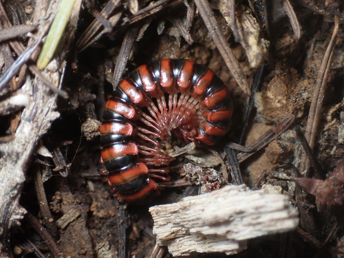
Selenocheir sinuata from Shasta County California
116:
Photo of
Selenocheir sinuata from Shasta County California
100:
80:
Commons is a freely licensed media file repository.
46:(500 × 375 pixels, file size: 224 KB, MIME type:
392:Creative Commons Attribution 4.0 International
61:
201:
8:
136:https://www.inaturalist.org/photos/364675646
256:https://creativecommons.org/licenses/by/4.0
232:– to copy, distribute and transmit the work
517:
283:
577:
493:
477:
459:
443:
425:
409:
389:
373:
353:
337:
317:
301:
298:
279:
272:
154:
175:View this and other nearby images on:
7:
575:The following page uses this file:
506:
299:In dieser Datei abgebildete Objekte
207:
292:
286:
223:
198:
110:
93:
39:
291:
262:Creative Commons Attribution 4.0
446:coordinates of the point of view
277:
243:Under the following conditions:
214:This file is licensed under the
206:
200:
181:
167:
60:
21:
274:
111:
36:No higher resolution available.
14:
273:
26:
1:
219:Attribution 4.0 International
461:40°51'36.22"N, 122°6'47.09"W
596:
507:
145:Chloe and Trevor Van Loon
16:
276:
67:This is a file from the
564:
543:21:53, 9 September 2024
141:
131:
124:
121:
106:Selenocheir sinuata.jpg
103:
71:. Information from its
42:Selenocheir_sinuata.jpg
187:40.860060; -122.113080
74:description page there
580:Selenocheir sinuata
320:Selenocheir sinuata
238:– to adapt the work
568:
376:copyright license
285:
192:
191:
149:
148:
89:
88:
69:Wikimedia Commons
587:
555:
340:copyright status
269:
266:
263:
260:
257:
216:Creative Commons
210:
209:
204:
203:
188:
185:
171:
170:
164:
163:
152:
127:
115:
107:
101:
85:
64:
63:
57:
51:
49:
595:
594:
590:
589:
588:
586:
585:
584:
569:
561:
553:
509:
508:
505:
504:
503:
502:
501:
500:
499:
498:
496:
486:
485:
484:
482:
471:
470:
469:
468:
467:
466:
465:
464:
462:
452:
451:
450:
448:
437:
436:
435:
434:
433:
432:
431:
430:
428:
418:
417:
416:
414:
403:
402:
401:
400:
399:
398:
397:
396:
394:
382:
381:
380:
378:
367:
366:
365:
364:
363:
362:
361:
360:
358:
346:
345:
344:
342:
331:
330:
329:
328:
327:
326:
325:
324:
322:
310:
309:
308:
306:
290:
289:
288:
271:
270:
267:
264:
261:
258:
255:
254:
222:
211:
197:
186:
159:
158:
155:Camera location
150:
117:
105:
98:
91:
90:
79:
78:
77:is shown below.
53:
47:
45:
38:
37:
12:
11:
5:
593:
591:
583:
582:
573:
572:
567:
566:
563:
559:
556:
550:
545:
540:
536:
535:
532:
529:
526:
523:
520:
513:
512:
497:
494:
492:
491:
490:
489:
488:
487:
483:
478:
476:
475:
474:
473:
472:
463:
460:
458:
457:
456:
455:
454:
453:
449:
444:
442:
441:
440:
439:
429:
426:
424:
423:
422:
421:
420:
419:
415:
410:
408:
407:
406:
405:
404:
395:
390:
388:
387:
386:
385:
384:
383:
379:
374:
372:
371:
370:
369:
368:
359:
354:
352:
351:
350:
349:
348:
347:
343:
338:
336:
335:
334:
333:
332:
323:
318:
316:
315:
314:
313:
312:
311:
307:
302:
300:
297:
296:
295:
294:
293:
282:
281:
278:
275:
253:
252:
251:
250:
241:
240:
239:
233:
226:You are free:
213:
212:
199:
196:
193:
190:
189:
179:
173:
156:
147:
146:
143:
139:
138:
133:
129:
128:
123:
119:
118:
108:
99:
97:
94:
92:
87:
86:
65:
55:
54:
35:
31:
30:
29:
24:
19:
13:
10:
9:
6:
4:
3:
2:
592:
581:
578:
576:
570:
562:
560:Degenhardt.jd
557:
551:
549:
546:
544:
541:
538:
537:
533:
530:
527:
524:
521:
519:
518:
516:
510:
481:
447:
413:
393:
377:
357:
341:
321:
305:
248:
245:
244:
242:
237:
234:
231:
228:
227:
225:
224:
220:
217:
205:
194:
184:
180:
178:
177:OpenStreetMap
174:
172:
162:
157:
153:
144:
140:
137:
134:
130:
120:
114:
109:
102:
95:
83:
76:
75:
70:
66:
59:
58:
52:
43:
34:
28:
25:
23:
20:
18:
15:
574:
514:
511:File history
427:6 April 2024
246:
235:
229:
126:6 April 2024
112:
82:You can help
72:
40:
22:File history
356:copyrighted
247:attribution
104:Description
571:File usage
552:500 × 375
528:Dimensions
495:image/jpeg
480:media type
259:CC BY 4.0
48:image/jpeg
27:File usage
525:Thumbnail
522:Date/Time
412:inception
195:Licensing
113:English:
554:(224 KB)
280:Captions
236:to remix
230:to share
221:license.
539:current
534:Comment
304:depicts
284:English
96:Summary
44:
165:
142:Author
132:Source
531:User
268:true
265:true
122:Date
17:File
84:.
50:)
Text is available under the Creative Commons Attribution-ShareAlike License. Additional terms may apply.