137:
43:
177:
280:
294:
183:
188:
99:
548:
271:
229:– You must give appropriate credit, provide a link to the license, and indicate if changes were made. You may do so in any reasonable manner, but not in any way that suggests the licensor endorses you or your use.
587:
65:
61:
57:
53:
47:
110:
78:
680:
144:
423:
387:
287:
351:
840:
703:
This file contains additional information, probably added from the digital camera or scanner used to create or digitize it.
493:
236:
809:
477:
443:
371:
592:
407:
335:
565:
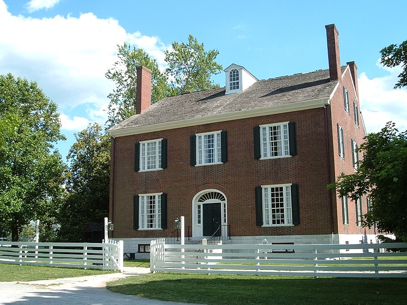
Photograph of the
Trustees House at Shaker Village at Pleasant Hill, Kentucky, USA Source: Photograph taken by
198:
706:
If the file has been modified from its original state, some details may not fully reflect the modified file.
602:
547:
542:
69:
42:
893:
235:– If you remix, transform, or build upon the material, you must distribute your contributions under the
195:
929:
607:
118:
169:
635:
570:
597:
566:
558:
293:
153:
997:
911:
867:
732:
105:
772:
725:
165:
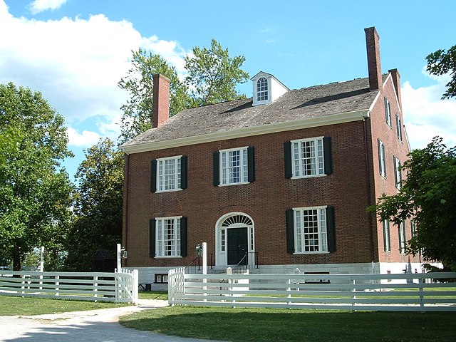
Photograph of the
Trustees House at Shaker Village at Pleasant Hill, Kentucky, USA
277:
939:
131:
752:
1015:
742:
715:
655:
660:
630:
515:
Click on a date/time to view the file as it appeared at that time.
835:
Landscape mode (for landscape photos with the background in focus)
436:
148:
279:
670:
262:
143:
This is an image of a place or building that is listed on the
93:
650:
272:
37° 49′ 14″ N, 84° 44′ 36″ W
319:
Add a one-line explanation of what this file represents
690:
645:
625:
83:(2,016 × 1,512 pixels, file size: 1.5 MB, MIME type:
117:
Commons is a freely licensed media file repository.
424:
Creative
Commons Attribution-ShareAlike 2.0 Generic
636:Liste der National Historic Landmarks in Kentucky
934:Flash did not fire, compulsory flash suppression
588:List of National Historic Landmarks in Kentucky
246:https://creativecommons.org/licenses/by-sa/2.0
98:
252:Creative Commons Attribution-Share Alike 2.0
176:
8:
212:– to copy, distribute and transmit the work
708:
517:
315:
618:The following other wikis use this file:
1023:
1013:
1005:
995:
987:
979:
971:
963:
955:
947:
937:
927:
919:
909:
901:
891:
883:
875:
865:
857:
849:
838:
830:
822:
814:
804:
796:
788:
780:
769:
761:
750:
740:
730:
720:
585:
491:
475:
457:
441:
421:
405:
385:
369:
349:
333:
330:
311:
304:
265:
810:Digital Camera FinePix A330 Ver1.73
286:View this and other nearby images on:
710:
583:The following 5 pages use this file:
7:
145:National Register of Historic Places
506:
199:Attribution-Share Alike 2.0 Generic
187:
182:
701:
324:
318:
173:
130:
76:
323:
763:Date and time of data generation
309:
292:
278:
223:Under the following conditions:
194:This file is licensed under the
186:
181:
175:
135:
97:
31:
21:
306:
14:
737:1/240 sec (0.0041666666666667)
459:37°49'14.002"N, 84°44'35.999"W
305:
26:
1:
444:coordinates of depicted place
36:
331:Items portrayed in this file
168:Source: Photograph taken by
965:Focal plane resolution unit
851:Date and time of digitizing
667:Usage on it.wikivoyage.org
593:List of museums in Kentucky
1045:
976:One-chip color area sensor
687:Usage on www.wikidata.org
677:Usage on ur.wikipedia.org
656:National Historic Landmark
642:Usage on fr.wikipedia.org
622:Usage on de.wikipedia.org
237:same or compatible license
151:. Its reference number is
816:File change date and time
507:
16:
957:Focal plane Y resolution
949:Focal plane X resolution
661:Pleasant Hill (Kentucky)
631:Mercer County (Kentucky)
308:
203:
149:United States of America
104:This is a file from the
981:Custom image processing
603:Pleasant Hill, Kentucky
564:
108:. Information from its
1025:Subject distance range
859:Image compression mode
298:37.820556; -84.743333
111:description page there
46:Size of this preview:
903:Maximum land aperture
790:Horizontal resolution
478:location of creation
70:2,016 × 1,512 pixels
824:Y and C positioning
798:Vertical resolution
712:Camera manufacturer
218:– to adapt the work
52:Other resolutions:
1007:Scene capture type
1002:Auto white balance
854:16:48, 27 May 2005
819:16:48, 27 May 2005
766:16:48, 27 May 2005
681:پلیزینٹ ہل، کینٹکی
608:Shaker communities
543:06:00, 28 May 2005
66:1,280 × 960 pixels
62:1,024 × 768 pixels
1032:
1031:
614:Global file usage
576:
571:Category:Kentucky
569:{{cc-by-sa-2.0}}
408:copyright license
317:
303:
302:
163:
162:
126:
125:
106:Wikimedia Commons
32:Global file usage
1036:
832:Exposure Program
709:
671:Bluegrass Region
555:
372:copyright status
299:
296:
282:
281:
275:
274:
263:
259:
256:
253:
250:
247:
239:as the original.
196:Creative Commons
190:
189:
185:
184:
179:
178:
156:
139:
138:
132:
122:
101:
100:
94:
88:
86:
73:
58:640 × 480 pixels
54:320 × 240 pixels
48:800 × 600 pixels
1044:
1043:
1039:
1038:
1037:
1035:
1034:
1033:
906:3 APEX (f/2.83)
885:APEX brightness
726:FinePix A330
697:
612:
598:Micajah Burnett
577:
561:
553:
509:
508:
505:
504:
503:
502:
501:
500:
499:
498:
496:
484:
483:
482:
480:
469:
468:
467:
466:
465:
464:
463:
462:
460:
450:
449:
448:
446:
435:
434:
433:
432:
431:
430:
429:
428:
426:
414:
413:
412:
410:
399:
398:
397:
396:
395:
394:
393:
392:
390:
378:
377:
376:
374:
363:
362:
361:
360:
359:
358:
357:
356:
354:
342:
341:
340:
338:
322:
321:
320:
297:
270:
269:
266:Object location
261:
260:
257:
254:
251:
248:
245:
244:
202:
191:
152:
136:
128:
127:
116:
115:
114:is shown below.
90:
84:
82:
75:
74:
51:
12:
11:
5:
1042:
1040:
1030:
1029:
1026:
1022:
1021:
1018:
1012:
1011:
1008:
1004:
1003:
1000:
994:
993:
990:
986:
985:
984:Normal process
982:
978:
977:
974:
973:Sensing method
970:
969:
966:
962:
961:
958:
954:
953:
950:
946:
945:
942:
936:
935:
932:
926:
925:
922:
918:
917:
914:
908:
907:
904:
900:
899:
896:
890:
889:
886:
882:
881:
878:
874:
873:
870:
864:
863:
860:
856:
855:
852:
848:
847:
844:
837:
836:
833:
829:
828:
825:
821:
820:
817:
813:
812:
807:
803:
802:
799:
795:
794:
791:
787:
786:
783:
779:
778:
775:
768:
767:
764:
760:
759:
756:
749:
748:
745:
739:
738:
735:
729:
728:
723:
719:
718:
713:
700:
696:
695:
694:
693:
685:
684:
683:
675:
674:
673:
665:
664:
663:
658:
653:
648:
640:
639:
638:
633:
628:
616:
615:
611:
610:
605:
600:
595:
590:
581:
580:
575:
574:
563:
559:
556:
552:2,016 × 1,512
550:
545:
540:
536:
535:
532:
529:
526:
523:
520:
513:
512:
497:
492:
490:
489:
488:
487:
486:
485:
481:
476:
474:
473:
472:
471:
470:
461:
458:
456:
455:
454:
453:
452:
451:
447:
442:
440:
439:
438:
437:
427:
422:
420:
419:
418:
417:
416:
415:
411:
406:
404:
403:
402:
401:
400:
391:
386:
384:
383:
382:
381:
380:
379:
375:
370:
368:
367:
366:
365:
364:
355:
350:
348:
347:
346:
345:
344:
343:
339:
334:
332:
329:
328:
327:
326:
325:
314:
313:
310:
307:
301:
300:
290:
284:
267:
243:
242:
241:
240:
230:
221:
220:
219:
213:
206:You are free:
193:
192:
174:
161:
160:
140:
129:
124:
123:
102:
92:
91:
45:
41:
40:
39:
34:
29:
24:
19:
13:
10:
9:
6:
4:
3:
2:
1041:
1027:
1024:
1019:
1017:
1014:
1009:
1006:
1001:
999:
998:White balance
996:
992:Auto exposure
991:
989:Exposure mode
988:
983:
980:
975:
972:
967:
964:
959:
956:
951:
948:
943:
941:
938:
933:
931:
928:
923:
920:
915:
913:
912:Metering mode
910:
905:
902:
897:
895:
894:Exposure bias
892:
887:
884:
879:
877:APEX aperture
876:
871:
869:
868:Shutter speed
866:
861:
858:
853:
850:
845:
842:
839:
834:
831:
826:
823:
818:
815:
811:
808:
806:Software used
805:
800:
797:
792:
789:
784:
781:
776:
774:
770:
765:
762:
757:
754:
751:
746:
744:
741:
736:
734:
733:Exposure time
731:
727:
724:
721:
717:
714:
711:
707:
704:
698:
692:
689:
688:
686:
682:
679:
678:
676:
672:
669:
668:
666:
662:
659:
657:
654:
652:
651:Pleasant Hill
649:
647:
644:
643:
641:
637:
634:
632:
629:
627:
624:
623:
621:
620:
619:
613:
609:
606:
604:
601:
599:
596:
594:
591:
589:
586:
584:
578:
572:
568:
562:
557:
551:
549:
546:
544:
541:
538:
537:
533:
530:
527:
524:
521:
519:
518:
516:
510:
495:
494:Mercer County
479:
445:
425:
409:
389:
373:
353:
352:Pleasant Hill
337:
295:
291:
289:
288:OpenStreetMap
285:
283:
273:
268:
264:
249:CC BY-SA 2.0
238:
234:
231:
228:
225:
224:
222:
217:
214:
211:
208:
207:
205:
204:
200:
197:
180:
172:
171:
166:
159:
158:
155:
150:
146:
141:
134:
133:
120:
113:
112:
107:
103:
96:
95:
89:
80:
79:Original file
71:
67:
63:
59:
55:
49:
44:
38:
35:
33:
30:
28:
25:
23:
20:
18:
15:
921:Light source
773:focal length
722:Camera model
705:
702:
617:
582:
514:
511:File history
232:
226:
215:
209:
167:
164:
142:
119:You can help
109:
77:
22:File history
940:Color space
782:Orientation
388:copyrighted
233:share alike
227:attribution
579:File usage
528:Dimensions
85:image/jpeg
27:File usage
1016:Sharpness
1010:Landscape
753:ISO speed
567:Tom Allen
560:Tom Allen
525:Thumbnail
522:Date/Time
170:Tom Allen
827:Co-sited
743:F-number
716:FUJIFILM
699:Metadata
691:Q3392171
646:Kentucky
626:Kentucky
554:(1.5 MB)
312:Captions
216:to remix
210:to share
201:license.
154:71000353
37:Metadata
1028:Unknown
924:Unknown
916:Pattern
843:version
539:current
534:Comment
336:depicts
316:English
147:in the
81:
801:72 dpi
793:72 dpi
785:Normal
777:5.7 mm
755:rating
276:
960:3,884
952:3,884
930:Flash
771:Lens
747:f/5.6
944:sRGB
888:8.52
841:Exif
531:User
258:true
255:true
17:File
872:7.9
846:2.2
758:100
68:|
64:|
60:|
56:|
50:.
1020:3
968:3
898:0
880:5
862:4
573:\
157:.
121:.
87:)
72:.
Text is available under the Creative Commons Attribution-ShareAlike License. Additional terms may apply.
