291:
224:
390:
238:
259:
297:
302:
72:
891:
215:
908:== {{int:filedesc}} == {{Information |description={{en|1=Site of Fernhill Heath Station. Now all that remains is the footbridge over the Worcester to Birmingham line. A prime candidate for renewal as this village continues to expand to become a dormer tow
43:
126:
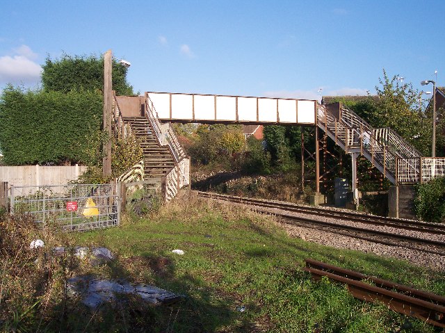
Site of
Fernhill Heath Station. Now all that remains is the footbridge over the Worcester to Birmingham line. A prime candidate for renewal as this village continues to expand to become a dormer town and eventually a suburb of
349:– You must give appropriate credit, provide a link to the license, and indicate if changes were made. You may do so in any reasonable manner, but not in any way that suggests the licensor endorses you or your use.
83:
51:
398:
415:
975:
751:
681:
645:
231:
890:
885:
771:
42:
1061:
922:
266:
953:
This file contains additional information, probably added from the digital camera or scanner used to create or digitize it.
356:
608:
822:
779:
735:
629:
601:
588:
573:
491:
794:
764:
701:
665:
546:
529:
438:
430:
253:
312:
956:
If the file has been modified from its original state, some details may not fully reflect the modified file.
411:
918:
The following pages on the
English Knowledge (XXG) use this file (pages on other projects are not listed):
1098:
965:
355:– If you remix, transform, or build upon the material, you must distribute your contributions under the
273:
on the
Geograph website for the photographer's contact details. The copyright on this image is owned by
901:
309:
1134:
419:
91:
184:
1223:
404:
Remove redundant categories and try to put this image in the most specific category/categories
168:
801:
786:
580:
482:
486:
478:
474:
470:
466:
462:
458:
454:
450:
446:
237:
1186:
1116:
1080:
982:
278:
78:
1233:
1196:
1011:
1144:
136:
221:
157:
147:
1243:
992:
258:
270:
858:
Click on a date/time to view the file as it appeared at that time.
223:
206:
66:
815:
116:
Site of
Fernhill Heath Station - geograph.org.uk - 77761.jpg
52:
Site_of_Fernhill_Heath_Station_-_geograph.org.uk_-_77761.jpg
216:
52° 13′ 53″ N, 2° 11′ 31″ W
513:
Add a one-line explanation of what this file represents
418:
combined with a database. You can also have a look at
410:
The location categories are based on information from
940:
110:
90:
Commons is a freely licensed media file repository.
682:
Creative
Commons Attribution-ShareAlike 2.0 Generic
56:(640 × 479 pixels, file size: 127 KB, MIME type:
395:The categories of this image should be checked.
366:https://creativecommons.org/licenses/by-sa/2.0
71:
372:Creative Commons Attribution-Share Alike 2.0
290:
8:
332:– to copy, distribute and transmit the work
958:
860:
509:
490:
933:The following other wikis use this file:
1251:
1241:
1231:
1221:
1213:
1205:
1194:
1184:
1176:
1168:
1160:
1152:
1142:
1132:
1124:
1114:
1106:
1096:
1088:
1078:
1070:
1059:
1051:
1043:
1035:
1027:
1019:
1008:
1000:
990:
980:
970:
920:
836:
820:
802:https://www.geograph.org.uk/photo/77761
749:
733:
715:
699:
679:
663:
643:
627:
581:https://www.geograph.org.uk/profile/125
560:
544:
527:
524:
505:
498:
437:This image was uploaded as part of the
209:
230:View this and other nearby images on:
960:
425:The topic category from Geograph was
7:
277:and is licensed for reuse under the
849:
313:Attribution-Share Alike 2.0 Generic
301:
296:
281:Attribution-ShareAlike 2.0 license.
951:
518:
512:
287:
264:
120:
103:
49:
517:
1002:Date and time of data generation
976:KODAK DX4530 ZOOM DIGITAL CAMERA
503:
388:
343:Under the following conditions:
308:This file is licensed under the
300:
295:
289:
257:
236:
222:
70:
31:
21:
500:
121:
46:No higher resolution available.
14:
923:Fernhill Heath railway station
752:file available on the internet
499:
265:This image was taken from the
199:Site of Fernhill Heath Station
180:Site of Fernhill Heath Station
26:
1:
1139:Flash did not fire, auto mode
823:coordinates of depicted place
36:
772:Geograph Britain and Ireland
602:object of statement has role
525:Items portrayed in this file
1072:Date and time of digitizing
1273:
1207:Focal length in 35 mm film
1165:One-chip color area sensor
937:Usage on www.wikidata.org
357:same or compatible license
850:
838:52°13'52.7"N, 2°11'31.2"W
197:Bob Embleton /
178:Bob Embleton /
16:
780:geograph.org.uk image ID
502:
420:this tool from mysociety
386:
385:
323:
77:This is a file from the
1170:Custom image processing
1075:15:05, 13 November 2005
1005:15:05, 13 November 2005
907:
416:this OpenStreetMap tool
169:required by the license
153:
142:
135:
132:
113:
81:. Information from its
1253:Subject distance range
886:19:05, 30 January 2010
271:this photograph's page
242:52.231300; -2.192000
84:description page there
1108:Maximum land aperture
1029:Horizontal resolution
966:EASTMAN KODAK COMPANY
439:Geograph batch upload
429:(find similar images
407:Remove this template
1045:Y and C positioning
1037:Vertical resolution
962:Camera manufacturer
483:português do Brasil
338:– to adapt the work
1215:Scene capture type
1191:Auto white balance
589:author name string
431:bridge at Geograph
412:this geonames tool
1260:
1259:
987:1/500 sec (0.002)
929:Global file usage
911:
666:copyright license
511:
494:
441:
286:
285:
269:collection. See
247:
246:
204:
203:
172:
99:
98:
79:Wikimedia Commons
32:Global file usage
1264:
1053:Exposure Program
959:
898:
804:
799:
795:described at URL
789:
784:
774:
769:
717:13 November 2005
630:copyright status
611:
606:
596:
593:
583:
578:
495:
436:
393:
392:
391:
379:
376:
373:
370:
367:
359:as the original.
321:
310:Creative Commons
304:
303:
299:
298:
293:
292:
279:Creative Commons
267:Geograph project
261:
254:
243:
240:
226:
225:
219:
218:
207:
166:
138:
137:13 November 2005
125:
117:
111:
95:
74:
73:
67:
61:
59:
1272:
1271:
1267:
1266:
1265:
1263:
1262:
1261:
1111:3 APEX (f/2.83)
947:
927:
919:
912:
904:
896:
852:
851:
848:
847:
846:
845:
844:
843:
842:
841:
839:
829:
828:
827:
825:
814:
813:
812:
811:
810:
809:
808:
807:
806:
805:
800:
797:
791:
790:
785:
782:
776:
775:
770:
767:
758:
757:
756:
754:
742:
741:
740:
738:
727:
726:
725:
724:
723:
722:
721:
720:
718:
708:
707:
706:
704:
693:
692:
691:
690:
689:
688:
687:
686:
684:
672:
671:
670:
668:
657:
656:
655:
654:
653:
652:
651:
650:
648:
636:
635:
634:
632:
621:
620:
619:
618:
617:
616:
615:
614:
613:
612:
607:
604:
598:
597:
594:
591:
585:
584:
579:
576:
567:
566:
565:
563:
553:
552:
551:
549:
538:
537:
536:
535:
534:
532:
516:
515:
514:
497:
445:
442:
399:Check them now!
389:
387:
381:
380:
377:
374:
371:
368:
365:
364:
322:
319:
316:
305:
282:
252:
241:
214:
213:
210:Object location
205:
194:
187:
175:
148:geograph.org.uk
128:
115:
108:
101:
100:
89:
88:
87:is shown below.
63:
57:
55:
48:
47:
12:
11:
5:
1270:
1268:
1258:
1257:
1254:
1250:
1249:
1246:
1240:
1239:
1236:
1230:
1229:
1226:
1220:
1219:
1216:
1212:
1211:
1208:
1204:
1203:
1200:
1193:
1192:
1189:
1183:
1182:
1179:
1175:
1174:
1173:Normal process
1171:
1167:
1166:
1163:
1162:Sensing method
1159:
1158:
1155:
1154:Exposure index
1151:
1150:
1147:
1141:
1140:
1137:
1131:
1130:
1127:
1123:
1122:
1119:
1113:
1112:
1109:
1105:
1104:
1101:
1095:
1094:
1091:
1087:
1086:
1083:
1077:
1076:
1073:
1069:
1068:
1065:
1058:
1057:
1056:Normal program
1054:
1050:
1049:
1046:
1042:
1041:
1038:
1034:
1033:
1030:
1026:
1025:
1022:
1018:
1017:
1014:
1007:
1006:
1003:
999:
998:
995:
989:
988:
985:
979:
978:
973:
969:
968:
963:
950:
946:
945:
944:
943:
931:
930:
926:
925:
917:
916:
915:
910:
909:
906:
902:
899:
893:
888:
883:
879:
878:
875:
872:
869:
866:
863:
856:
855:
840:
837:
835:
834:
833:
832:
831:
830:
826:
821:
819:
818:
817:
816:
793:
792:
778:
777:
763:
762:
761:
760:
759:
755:
750:
748:
747:
746:
745:
744:
743:
739:
736:source of file
734:
732:
731:
730:
729:
728:
719:
716:
714:
713:
712:
711:
710:
709:
705:
700:
698:
697:
696:
695:
694:
685:
680:
678:
677:
676:
675:
674:
673:
669:
664:
662:
661:
660:
659:
658:
649:
644:
642:
641:
640:
639:
638:
637:
633:
628:
626:
625:
624:
623:
622:
600:
599:
587:
586:
572:
571:
570:
569:
568:
564:
561:
559:
558:
557:
556:
555:
554:
550:
545:
543:
542:
541:
540:
539:
533:
528:
526:
523:
522:
521:
520:
519:
508:
507:
504:
501:
435:
434:
427:Railway bridge
423:
408:
405:
363:
362:
361:
360:
350:
341:
340:
339:
333:
326:You are free:
317:
307:
306:
288:
284:
283:
262:
251:
248:
245:
244:
234:
228:
211:
202:
201:
195:
192:
189:
188:
183:
176:
173:
161:
160:
155:
151:
150:
144:
140:
139:
134:
130:
129:
118:
109:
107:
104:
102:
97:
96:
75:
65:
64:
45:
41:
40:
39:
34:
29:
24:
19:
13:
10:
9:
6:
4:
3:
2:
1269:
1255:
1252:
1247:
1245:
1242:
1237:
1235:
1232:
1227:
1225:
1222:
1217:
1214:
1209:
1206:
1201:
1198:
1195:
1190:
1188:
1187:White balance
1185:
1181:Auto exposure
1180:
1178:Exposure mode
1177:
1172:
1169:
1164:
1161:
1156:
1153:
1148:
1146:
1143:
1138:
1136:
1133:
1128:
1125:
1120:
1118:
1117:Metering mode
1115:
1110:
1107:
1102:
1100:
1099:Exposure bias
1097:
1092:
1090:APEX aperture
1089:
1084:
1082:
1081:Shutter speed
1079:
1074:
1071:
1066:
1063:
1060:
1055:
1052:
1047:
1044:
1039:
1036:
1031:
1028:
1023:
1020:
1015:
1013:
1009:
1004:
1001:
996:
994:
991:
986:
984:
983:Exposure time
981:
977:
974:
971:
967:
964:
961:
957:
954:
948:
942:
939:
938:
936:
935:
934:
928:
924:
921:
913:
905:
900:
894:
892:
889:
887:
884:
881:
880:
876:
873:
870:
867:
864:
862:
861:
859:
853:
824:
803:
796:
788:
781:
773:
766:
753:
737:
703:
683:
667:
647:
631:
610:
603:
590:
582:
575:
548:
531:
496:
493:
488:
484:
480:
476:
472:
468:
464:
460:
456:
452:
448:
443:
440:
432:
428:
424:
421:
417:
413:
409:
406:
403:
402:
401:
400:
396:
384:
383:
369:CC BY-SA 2.0
358:
354:
351:
348:
345:
344:
342:
337:
334:
331:
328:
327:
325:
324:
318:Attribution:
314:
311:
294:
280:
276:
272:
268:
263:
260:
256:
255:
249:
239:
235:
233:
232:OpenStreetMap
229:
227:
217:
212:
208:
200:
196:
191:
190:
186:
182: /
181:
177:
170:
165:
163:
162:
159:
156:
152:
149:
145:
141:
131:
124:
119:
112:
105:
93:
86:
85:
80:
76:
69:
68:
62:
53:
44:
38:
35:
33:
30:
28:
25:
23:
20:
18:
15:
1197:Digital zoom
1126:Light source
1012:focal length
972:Camera model
955:
952:
932:
857:
854:File history
609:photographer
595:Bob Embleton
444:
426:
397:
394:
382:
352:
346:
335:
329:
320:Bob Embleton
275:Bob Embleton
274:
198:
185:CC BY-SA 2.0
179:
158:Bob Embleton
122:
92:You can help
82:
50:
22:File history
1145:Color space
1021:Orientation
903:GeographBot
646:copyrighted
353:share alike
347:attribution
164:Attribution
114:Description
1234:Saturation
914:File usage
895:640 × 479
871:Dimensions
562:some value
471:македонски
127:Worcester.
58:image/jpeg
27:File usage
1244:Sharpness
868:Thumbnail
865:Date/Time
702:inception
479:português
250:Licensing
193:InfoField
174:InfoField
123:English:
1224:Contrast
1218:Standard
1048:Centered
993:F-number
949:Metadata
941:Q5445093
897:(127 KB)
765:operator
506:Captions
489: |
485: |
481: |
477: |
473: |
469: |
465: |
461: |
457: |
455:français
453: |
449: |
336:to remix
330:to share
315:license.
37:Metadata
1256:Unknown
1129:Unknown
1121:Pattern
1064:version
1040:230 dpi
1032:230 dpi
882:current
877:Comment
547:creator
530:depicts
510:English
447:English
106:Summary
54:
1248:Normal
1238:Normal
1228:Normal
1024:Normal
487:Türkçe
475:മലയാളം
467:magyar
459:galego
220:
154:Author
143:Source
1210:38 mm
1199:ratio
1135:Flash
1010:Lens
997:f/4.8
787:77761
463:עברית
451:suomi
146:From
1149:sRGB
1062:Exif
1016:8 mm
874:User
414:and
378:true
375:true
133:Date
17:File
1157:120
1093:4.5
1067:2.2
574:URL
492:+/−
798::
783::
768::
605::
592::
577::
1202:0
1103:0
1085:9
433:)
422:.
171:)
167:(
94:.
60:)
Text is available under the Creative Commons Attribution-ShareAlike License. Additional terms may apply.
_&language=en)
