43:
252:
213:
227:
258:
263:
103:
880:
157:
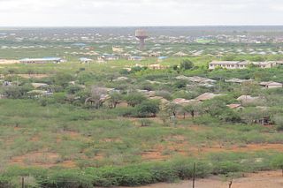
Skyline of Bura town, Tana River Kenya. The picture is taken from the main water tower. In the middle right the offices of the Bura
Irrigation and Settlement Project can be seen. The water tower in the centre of the picture distributes water in Bura Rural
304:– You must give appropriate credit, provide a link to the license, and indicate if changes were made. You may do so in any reasonable manner, but not in any way that suggests the licensor endorses you or your use.
204:
187:
69:
65:
61:
57:
53:
47:
114:
82:
713:
625:
521:
485:
220:
916:
967:
This file contains additional information, probably added from the digital camera or scanner used to create or digitize it.
311:
420:
808:
771:
734:
679:
645:
609:
575:
469:
441:
428:
413:
706:
541:
505:
386:
369:
448:
273:
970:
If the file has been modified from its original state, some details may not fully reflect the modified file.
911:
907:
The following pages on the
English Knowledge (XXG) use this file (pages on other projects are not listed):
310:– If you remix, transform, or build upon the material, you must distribute your contributions under the
270:
890:
879:
874:
73:
42:
122:
226:
109:
245:
I, the copyright holder of this work, hereby publish it under the following license:
210:
167:
847:
Click on a date/time to view the file as it appeared at that time.
568:
212:
205:
1° 10′ 40.44″ S, 39° 49′ 43.45″ E
195:
97:
944:
934:
522:
Creative
Commons Attribution-ShareAlike 4.0 International
353:
Add a one-line explanation of what this file represents
87:(4,000 × 2,664 pixels, file size: 1.96 MB, MIME type:
954:
141:
121:
Commons is a freely licensed media file repository.
321:https://creativecommons.org/licenses/by-sa/4.0
102:
327:Creative Commons Attribution-Share Alike 4.0
251:
8:
287:– to copy, distribute and transmit the work
972:
849:
349:
927:The following other wikis use this file:
274:Attribution-Share Alike 4.0 International
695:77c98d41761c69c5ad57292f6490f01b97867ab5
974:
909:
822:
806:
785:
769:
748:
732:
693:
677:
659:
643:
623:
607:
589:
573:
555:
539:
519:
503:
483:
467:
400:
384:
367:
364:
345:
338:
198:
219:View this and other nearby images on:
7:
897:User created page with UploadWizard
838:
262:
257:
965:
358:
352:
248:
244:
151:
134:
80:
357:
147:Skyline from main water tower.jpg
576:coordinates of the point of view
343:
298:Under the following conditions:
269:This file is licensed under the
261:
256:
250:
225:
211:
101:
31:
21:
340:
152:
14:
917:User:Jerome KL/Example infobox
339:
26:
1:
626:original creation by uploader
591:1°10'40.444"S, 39°49'43.450"E
36:
414:object of statement has role
365:Items portrayed in this file
996:
951:Usage on www.wikidata.org
941:Usage on sw.wikipedia.org
931:Usage on sv.wikipedia.org
312:same or compatible license
839:
177:
16:
342:
278:
108:This is a file from the
912:Bura, Tana River County
896:
875:19:35, 10 February 2017
183:
173:
166:
163:
144:
112:. Information from its
231:-1.177901; 39.828736
115:description page there
46:Size of this preview:
707:determination method
74:4,000 × 2,664 pixels
70:2,560 × 1,705 pixels
293:– to adapt the work
52:Other resolutions:
442:Wikimedia username
429:author name string
66:1,280 × 852 pixels
62:1,024 × 682 pixels
983:
982:
976:Rating (out of 5)
923:Global file usage
900:
506:copyright license
351:
236:
235:
193:
192:
130:
129:
110:Wikimedia Commons
32:Global file usage
987:
973:
945:Bura, Tana River
935:Bura, Tana River
887:
827:
790:
753:
716:
711:
470:copyright status
451:
446:
436:
433:
423:
418:
334:
331:
328:
325:
322:
314:as the original.
271:Creative Commons
265:
264:
260:
259:
254:
253:
232:
229:
215:
214:
208:
207:
196:
179:
169:
156:
148:
142:
126:
105:
104:
98:
92:
90:
77:
58:640 × 426 pixels
54:320 × 213 pixels
48:800 × 533 pixels
995:
994:
990:
989:
988:
986:
985:
984:
961:
921:
908:
901:
893:
885:
841:
840:
837:
836:
835:
834:
833:
832:
831:
830:
828:
825:
815:
814:
813:
811:
800:
799:
798:
797:
796:
795:
794:
793:
791:
788:
778:
777:
776:
774:
763:
762:
761:
760:
759:
758:
757:
756:
754:
751:
741:
740:
739:
737:
726:
725:
724:
723:
722:
721:
720:
719:
718:
717:
712:
709:
700:
699:
698:
696:
686:
685:
684:
682:
671:
670:
669:
668:
667:
666:
665:
664:
662:
652:
651:
650:
648:
637:
636:
635:
634:
633:
632:
631:
630:
628:
616:
615:
614:
612:
601:
600:
599:
598:
597:
596:
595:
594:
592:
582:
581:
580:
578:
567:
566:
565:
564:
563:
562:
561:
560:
558:
548:
547:
546:
544:
533:
532:
531:
530:
529:
528:
527:
526:
524:
512:
511:
510:
508:
497:
496:
495:
494:
493:
492:
491:
490:
488:
476:
475:
474:
472:
461:
460:
459:
458:
457:
456:
455:
454:
453:
452:
447:
444:
438:
437:
434:
431:
425:
424:
419:
416:
407:
406:
405:
403:
393:
392:
391:
389:
378:
377:
376:
375:
374:
372:
356:
355:
354:
337:
336:
335:
332:
329:
326:
323:
320:
319:
277:
266:
247:
246:
241:
230:
203:
202:
199:Camera location
194:
159:
146:
139:
132:
131:
120:
119:
118:is shown below.
94:
88:
86:
79:
78:
51:
12:
11:
5:
993:
991:
981:
980:
977:
964:
960:
959:
958:
957:
949:
948:
947:
939:
938:
937:
925:
924:
920:
919:
914:
906:
905:
904:
899:
898:
895:
891:
888:
884:4,000 × 2,664
882:
877:
872:
868:
867:
864:
861:
858:
855:
852:
845:
844:
829:
823:
821:
820:
819:
818:
817:
816:
812:
807:
805:
804:
803:
802:
801:
792:
786:
784:
783:
782:
781:
780:
779:
775:
770:
768:
767:
766:
765:
764:
755:
749:
747:
746:
745:
744:
743:
742:
738:
733:
731:
730:
729:
728:
727:
705:
704:
703:
702:
701:
697:
694:
692:
691:
690:
689:
688:
687:
683:
678:
676:
675:
674:
673:
672:
663:
660:
658:
657:
656:
655:
654:
653:
649:
644:
642:
641:
640:
639:
638:
629:
624:
622:
621:
620:
619:
618:
617:
613:
610:source of file
608:
606:
605:
604:
603:
602:
593:
590:
588:
587:
586:
585:
584:
583:
579:
574:
572:
571:
570:
569:
559:
556:
554:
553:
552:
551:
550:
549:
545:
540:
538:
537:
536:
535:
534:
525:
520:
518:
517:
516:
515:
514:
513:
509:
504:
502:
501:
500:
499:
498:
489:
484:
482:
481:
480:
479:
478:
477:
473:
468:
466:
465:
464:
463:
462:
440:
439:
427:
426:
412:
411:
410:
409:
408:
404:
401:
399:
398:
397:
396:
395:
394:
390:
385:
383:
382:
381:
380:
379:
373:
368:
366:
363:
362:
361:
360:
359:
348:
347:
344:
341:
318:
317:
316:
315:
305:
296:
295:
294:
288:
281:You are free:
268:
267:
249:
243:
242:
240:
237:
234:
233:
223:
217:
200:
191:
190:
185:
181:
180:
175:
171:
170:
165:
161:
160:
149:
140:
138:
135:
133:
128:
127:
106:
96:
95:
45:
41:
40:
39:
34:
29:
24:
19:
13:
10:
9:
6:
4:
3:
2:
992:
978:
975:
971:
968:
962:
956:
953:
952:
950:
946:
943:
942:
940:
936:
933:
932:
930:
929:
928:
922:
918:
915:
913:
910:
902:
894:
889:
883:
881:
878:
876:
873:
870:
869:
865:
862:
859:
856:
853:
851:
850:
848:
842:
810:
773:
736:
715:
708:
681:
647:
627:
611:
577:
557:25 March 2014
543:
523:
507:
487:
471:
450:
443:
430:
422:
415:
388:
371:
324:CC BY-SA 4.0
313:
309:
306:
303:
300:
299:
297:
292:
289:
286:
283:
282:
280:
279:
275:
272:
255:
238:
228:
224:
222:
221:OpenStreetMap
218:
216:
206:
201:
197:
189:
186:
182:
176:
172:
168:25 March 2014
162:
155:
150:
143:
136:
124:
117:
116:
111:
107:
100:
99:
93:
84:
83:Original file
75:
71:
67:
63:
59:
55:
49:
44:
38:
35:
33:
30:
28:
25:
23:
20:
18:
15:
969:
966:
926:
846:
843:File history
421:photographer
307:
301:
290:
284:
153:
123:You can help
113:
81:
22:File history
486:copyrighted
308:share alike
302:attribution
145:Description
903:File usage
860:Dimensions
750:2,056,955
661:image/jpeg
646:media type
402:some value
89:image/jpeg
27:File usage
892:Jerome KL
886:(1.96 MB)
857:Thumbnail
854:Date/Time
735:data size
542:inception
449:Jerome KL
435:Jerome KL
239:Licensing
188:Jerome KL
154:English:
963:Metadata
955:Q4998061
680:checksum
346:Captions
291:to remix
285:to share
276:license.
178:Own work
37:Metadata
871:current
866:Comment
387:creator
370:depicts
350:English
158:Centre.
137:Summary
85:
824:4,000
787:2,664
772:height
209:
184:Author
174:Source
826:pixel
809:width
789:pixel
714:SHA-1
863:User
752:byte
333:true
330:true
164:Date
17:File
710::
445::
432::
417::
72:|
68:|
64:|
60:|
56:|
50:.
979:0
125:.
91:)
76:.
Text is available under the Creative Commons Attribution-ShareAlike License. Additional terms may apply.
