347:
280:
230:
272:
222:
294:
244:
315:
353:
358:
82:
150:
now forms the
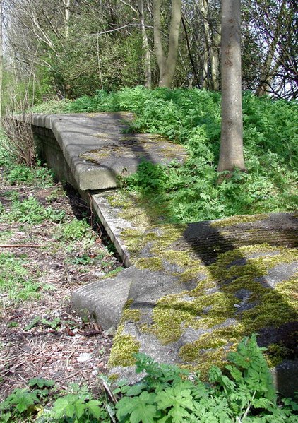
Hornsea Rail Trail and the eastern stretch of the Trans Pennine Trail. The Trans Pennine Trail runs for 215 miles from Hornsea to Southport and was officially opened in September 2001. There's a small building on the Ordnance Survey 1:25000 scale map just north of the former level crossing here at Oubrough, but this building no longer exists.
823:"}},"text\/plain":{"en":{"":"heading"}}},"{\"value\":{\"amount\":\"+45\",\"unit\":\"http:\\\/\\\/www.wikidata.org\\\/entity\\\/Q28390\"},\"type\":\"quantity\"}":{"text\/html":{"en":{"P7787":"45
759:"}},"text\/plain":{"en":{"":"heading"}}},"{\"value\":{\"amount\":\"+45\",\"unit\":\"http:\\\/\\\/www.wikidata.org\\\/entity\\\/Q28390\"},\"type\":\"quantity\"}":{"text\/html":{"en":{"P7787":"45
38:
755:
925:
945:{{geograph|775447|Paul Glazzard}} Original description: '''Skirlaugh Station''' End of the platform on the site of Skirlaugh Station, where the dismantled Hull & Hornsea Railway crosses the A165 Oubrough Lane, west
213:
405:– You must give appropriate credit, provide a link to the license, and indicate if changes were made. You may do so in any reasonable manner, but not in any way that suggests the licensor endorses you or your use.
820:
756:
48:
42:
93:
61:
191:
140:
657:
621:
585:
287:
237:
707:
322:
412:
520:
861:
834:
797:
770:
685:
641:
569:
541:
528:
513:
728:
700:
670:
605:
486:
469:
136:
309:
144:
959:
942:
368:
411:– If you remix, transform, or build upon the material, you must distribute your contributions under the
329:
on the
Geograph website for the photographer's contact details. The copyright on this image is owned by
365:
827:"}},"text\/plain":{"en":{"P7787":"45 degree"}}}}": -->
763:"}},"text\/plain":{"en":{"P7787":"45 degree"}}}}": -->
924:
919:
101:
52:
37:
692:
677:
548:
293:
243:
334:
88:
227:
935:
159:
277:
180:
170:
314:
326:
892:
Click on a date/time to view the file as it appeared at that time.
279:
229:
214:
53° 49′ 14.23″ N, 0° 14′ 55.62″ W
254:
204:
76:
264:
53° 49′ 14″ N, 0° 14′ 55″ W
453:
Add a one-line explanation of what this file represents
977:
198:
Creative
Commons Attribution Share-alike license 2.0
120:
100:
Commons is a freely licensed media file repository.
622:
Creative
Commons Attribution-ShareAlike 2.0 Generic
66:(451 × 640 pixels, file size: 156 KB, MIME type:
422:https://creativecommons.org/licenses/by-sa/2.0
81:
428:Creative Commons Attribution-Share Alike 2.0
346:
8:
824:
760:
388:– to copy, distribute and transmit the work
894:
449:
970:The following other wikis use this file:
678:https://www.geograph.org.uk/photo/775447
549:https://www.geograph.org.uk/profile/6470
957:
848:
832:
784:
768:
742:
726:
655:
639:
619:
603:
583:
567:
500:
484:
467:
464:
445:
438:
257:
207:
286:View this and other nearby images on:
236:View this and other nearby images on:
7:
333:and is licensed for reuse under the
955:The following page uses this file:
883:
369:Attribution-Share Alike 2.0 Generic
357:
352:
337:Attribution-ShareAlike 2.0 license.
458:
452:
343:
320:
130:
113:
59:
457:
771:coordinates of the point of view
443:
399:Under the following conditions:
364:This file is licensed under the
356:
351:
345:
313:
292:
278:
270:
242:
228:
220:
80:
31:
21:
440:
131:
126:Skirlaugh railway station 1.jpg
14:
658:file available on the internet
439:
321:This image was taken from the
26:
1:
835:coordinates of depicted place
786:53°49'14.228"N, 0°14'55.619"W
708:Geograph Britain and Ireland
514:object of statement has role
465:Items portrayed in this file
943:w:Skirlaugh railway station
850:53°49'14.38"N, 0°14'55.32"W
269:
219:
996:
974:Usage on www.wikidata.org
413:same or compatible license
960:Skirlaugh railway station
884:
137:Skirlaugh railway station
16:
686:geograph.org.uk image ID
442:
379:
145:East Riding of Yorkshire
87:This is a file from the
941:
186:
176:
165:
158:
155:
123:
91:. Information from its
327:this photograph's page
298:53.820660; -0.248700
248:53.820619; -0.248783
94:description page there
41:Size of this preview:
920:06:45, 30 April 2008
394:– to adapt the work
47:Other resolutions:
529:author name string
966:Global file usage
948:
826:
762:
606:copyright license
451:
342:
341:
325:collection. See
303:
302:
253:
252:
202:
201:
195:
192:Reusing this file
109:
108:
89:Wikimedia Commons
32:Global file usage
987:
932:
872:
871:
866:
808:
807:
802:
710:
705:
695:
690:
680:
675:
671:described at URL
570:copyright status
551:
546:
536:
533:
523:
518:
435:
432:
429:
426:
423:
415:as the original.
377:
366:Creative Commons
360:
359:
355:
354:
349:
348:
335:Creative Commons
323:Geograph project
317:
310:
299:
296:
282:
281:
275:
274:
273:
267:
266:
255:
249:
246:
232:
231:
225:
224:
223:
217:
216:
205:
189:
161:
135:
127:
121:
105:
84:
83:
77:
71:
69:
56:
53:451 × 640 pixels
49:169 × 240 pixels
43:422 × 599 pixels
995:
994:
990:
989:
988:
986:
985:
984:
964:
949:
938:
930:
886:
885:
882:
881:
880:
879:
878:
877:
876:
875:
874:
873:
869:
867:
864:
855:
854:
853:
851:
841:
840:
839:
837:
818:
817:
816:
815:
814:
813:
812:
811:
810:
809:
805:
803:
800:
791:
790:
789:
787:
777:
776:
775:
773:
754:
753:
752:
751:
750:
749:
748:
747:
745:
735:
734:
733:
731:
720:
719:
718:
717:
716:
715:
714:
713:
712:
711:
706:
703:
697:
696:
691:
688:
682:
681:
676:
673:
664:
663:
662:
660:
648:
647:
646:
644:
633:
632:
631:
630:
629:
628:
627:
626:
624:
612:
611:
610:
608:
597:
596:
595:
594:
593:
592:
591:
590:
588:
576:
575:
574:
572:
561:
560:
559:
558:
557:
556:
555:
554:
553:
552:
547:
544:
538:
537:
534:
531:
525:
524:
519:
516:
507:
506:
505:
503:
493:
492:
491:
489:
478:
477:
476:
475:
474:
472:
456:
455:
454:
437:
436:
433:
430:
427:
424:
421:
420:
378:
375:
372:
361:
338:
308:
297:
271:
262:
261:
258:Object location
247:
221:
212:
211:
208:Camera location
203:
171:geograph.org.uk
151:
125:
118:
111:
110:
99:
98:
97:is shown below.
73:
67:
65:
58:
57:
46:
12:
11:
5:
993:
991:
983:
982:
981:
980:
968:
967:
963:
962:
953:
952:
947:
946:
940:
936:
933:
927:
922:
917:
913:
912:
909:
906:
903:
900:
897:
890:
889:
860:
859:
858:
857:
856:
852:
849:
847:
846:
845:
844:
843:
842:
838:
833:
831:
830:
829:
828:
822:
796:
795:
794:
793:
792:
788:
785:
783:
782:
781:
780:
779:
778:
774:
769:
767:
766:
765:
764:
758:
746:
743:
741:
740:
739:
738:
737:
736:
732:
727:
725:
724:
723:
722:
721:
699:
698:
684:
683:
669:
668:
667:
666:
665:
661:
656:
654:
653:
652:
651:
650:
649:
645:
642:source of file
640:
638:
637:
636:
635:
634:
625:
620:
618:
617:
616:
615:
614:
613:
609:
604:
602:
601:
600:
599:
598:
589:
584:
582:
581:
580:
579:
578:
577:
573:
568:
566:
565:
564:
563:
562:
540:
539:
527:
526:
512:
511:
510:
509:
508:
504:
501:
499:
498:
497:
496:
495:
494:
490:
485:
483:
482:
481:
480:
479:
473:
468:
466:
463:
462:
461:
460:
459:
448:
447:
444:
441:
419:
418:
417:
416:
406:
397:
396:
395:
389:
382:You are free:
373:
363:
362:
344:
340:
339:
318:
307:
304:
301:
300:
290:
284:
259:
251:
250:
240:
234:
209:
200:
199:
196:
184:
183:
178:
174:
173:
167:
163:
162:
157:
153:
152:
128:
119:
117:
114:
112:
107:
106:
85:
75:
74:
40:
36:
35:
34:
29:
24:
19:
13:
10:
9:
6:
4:
3:
2:
992:
979:
976:
975:
973:
972:
971:
965:
961:
958:
956:
950:
944:
939:
934:
928:
926:
923:
921:
918:
915:
914:
910:
907:
904:
901:
898:
896:
895:
893:
887:
863:
836:
799:
772:
744:21 April 2008
730:
709:
702:
694:
687:
679:
672:
659:
643:
623:
607:
587:
571:
550:
543:
535:Paul Glazzard
530:
522:
515:
488:
471:
425:CC BY-SA 2.0
414:
410:
407:
404:
401:
400:
398:
393:
390:
387:
384:
383:
381:
380:
376:Paul Glazzard
374:Attribution:
370:
367:
350:
336:
332:
331:Paul Glazzard
328:
324:
319:
316:
312:
311:
305:
295:
291:
289:
288:OpenStreetMap
285:
283:
265:
260:
256:
245:
241:
239:
238:OpenStreetMap
235:
233:
215:
210:
206:
197:
193:
188:
185:
182:
181:Paul Glazzard
179:
175:
172:
168:
164:
160:21 April 2008
154:
148:
146:
142:
138:
134:
129:
122:
115:
103:
96:
95:
90:
86:
79:
78:
72:
63:
62:Original file
54:
50:
44:
39:
33:
30:
28:
25:
23:
20:
18:
15:
969:
954:
891:
888:File history
521:photographer
408:
402:
391:
385:
330:
268:
218:
132:
102:You can help
92:
60:
22:File history
586:copyrighted
409:share alike
403:attribution
124:Description
951:File usage
929:451 × 640
905:Dimensions
502:some value
187:Permission
147:, England.
68:image/jpeg
27:File usage
902:Thumbnail
899:Date/Time
729:inception
306:Licensing
133:English:
978:Q7535892
931:(156 KB)
701:operator
446:Captions
392:to remix
386:to share
371:license.
916:current
911:Comment
862:heading
821:heading
798:heading
757:heading
487:creator
470:depicts
450:English
141:Ellerby
116:Summary
64:
937:Edward
870:degree
825:degree
806:degree
761:degree
693:775447
276:
226:
177:Author
166:Source
169:From
908:User
434:true
431:true
156:Date
17:File
868:45
804:45
542:URL
865::
801::
704::
689::
674::
545::
532::
517::
143:,
139:,
51:|
45:.
194:)
190:(
104:.
70:)
55:.
Text is available under the Creative Commons Attribution-ShareAlike License. Additional terms may apply.

_region:GB-GBN_heading:45.00&language=en)
