395:
328:
278:
320:
270:
1188:
342:
292:
363:
401:
406:
1030:
72:
892:"}},"text\/plain":{"en":{"":"heading"}}},"{\"value\":{\"amount\":\"+45\",\"unit\":\"http:\\\/\\\/www.wikidata.org\\\/entity\\\/Q28390\"},\"type\":\"quantity\"}":{"text\/html":{"en":{"P7787":"45
828:"}},"text\/plain":{"en":{"":"heading"}}},"{\"value\":{\"amount\":\"+45\",\"unit\":\"http:\\\/\\\/www.wikidata.org\\\/entity\\\/Q28390\"},\"type\":\"quantity\"}":{"text\/html":{"en":{"P7787":"45
824:
43:
261:
1070:
51:
83:
453:– You must give appropriate credit, provide a link to the license, and indicate if changes were made. You may do so in any reasonable manner, but not in any way that suggests the licensor endorses you or your use.
889:
825:
1080:
1029:
1024:
42:
1065:
198:
509:"}},"text\/plain":{"en":{"P180":"St Mary the Virgin's Church, Little Bromley"}}}}": -->
760:
690:
654:
335:
285:
975:
780:
535:
370:
1246:
This file contains additional information, probably added from the digital camera or scanner used to create or digitize it.
460:
1040:
617:
959:
930:
903:
866:
839:
788:
744:
638:
610:
597:
582:
1047:== Summary == {{Information |Description=St. Mary the Virgin church, Little Bromley, Essex |Source=From ; transferd by
803:
773:
710:
674:
555:
519:
357:
416:
1249:
If the file has been modified from its original state, some details may not fully reflect the modified file.
1128:
459:– If you remix, transform, or build upon the material, you must distribute your contributions under the
377:
on the
Geograph website for the photographer's contact details. The copyright on this image is owned by
413:
115:
1061:
The following pages on the
English Knowledge use this file (pages on other projects are not listed):
896:"}},"text\/plain":{"en":{"P7787":"45 degree"}}}}": -->
832:"}},"text\/plain":{"en":{"P7787":"45 degree"}}}}": -->
91:
230:
1118:
110:
810:
795:
589:
214:
1075:
341:
291:
382:
78:
1071:
List of churches preserved by the
Churches Conservation Trust in the East of England
148:
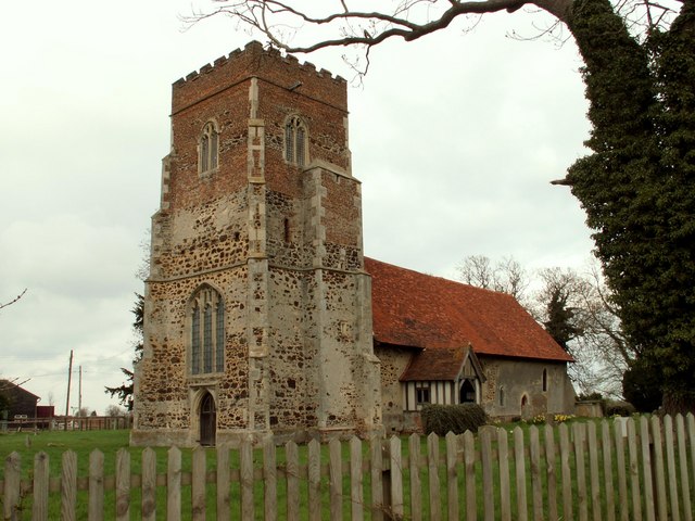
Parish church of St Mary the Virgin, Little
Bromley, Essex, seen from the southwest
1048:
275:
138:
St. Mary the Virgin church, Little
Bromley, Essex - geograph.org.uk - 158497.jpg
52:
St._Mary_the_Virgin_church,_Little_Bromley,_Essex_-_geograph.org.uk_-_158497.jpg
157:
325:
187:
172:
168:
362:
1189:Список церквей в Восточной Англии, сохранённых Фондом сохранения церквей
374:
997:
Click on a date/time to view the file as it appeared at that time.
327:
277:
1198:
1051:
using [http://toolserver.org/~magnus/geograph_org2commons.php g
262:
51° 54′ 34.09″ N, 1° 02′ 18.87″ E
176:
302:
252:
66:
1158:
1098:
1218:
1208:
1178:
1168:
1148:
1138:
1108:
312:
51° 54′ 36″ N, 1° 02′ 20″ E
501:
Add a one-line explanation of what this file represents
1233:
1228:
205:
Creative
Commons Attribution Share-alike license 2.0
132:
104:
90:
Commons is a freely licensed media file repository.
691:
Creative
Commons Attribution-ShareAlike 2.0 Generic
245:St. Mary the Virgin church, Little Bromley, Essex
226:St. Mary the Virgin church, Little Bromley, Essex
1119:Liste der Backsteinbauwerke der Gotik in England
1081:St Mary the Virgin's Church, Little Bromley
56:(640 × 480 pixels, file size: 80 KB, MIME type:
470:https://creativecommons.org/licenses/by-sa/2.0
71:
476:Creative Commons Attribution-Share Alike 2.0
394:
8:
893:
829:
536:St Mary the Virgin's Church, Little Bromley
436:– to copy, distribute and transmit the work
1251:
999:
497:
1091:The following other wikis use this file:
811:https://www.geograph.org.uk/photo/158497
590:https://www.geograph.org.uk/profile/3763
1253:
1063:
973:
957:
917:
901:
853:
837:
758:
742:
724:
708:
688:
672:
652:
636:
569:
553:
533:
517:
514:
493:
486:
305:
255:
1066:Grade II* listed buildings in Tendring
334:View this and other nearby images on:
284:View this and other nearby images on:
7:
381:and is licensed for reuse under the
988:
417:Attribution-Share Alike 2.0 Generic
405:
400:
385:Attribution-ShareAlike 2.0 license.
1244:
506:
500:
391:
368:
142:
108:
103:
49:
507:
840:coordinates of the point of view
491:
447:Under the following conditions:
412:This file is licensed under the
404:
399:
393:
361:
340:
326:
318:
290:
276:
268:
70:
31:
21:
1042:File Upload Bot (Magnus Manske)
488:
143:
46:No higher resolution available.
14:
1195:Usage on simple.wikipedia.org
761:file available on the internet
487:
369:This image was taken from the
26:
1:
904:coordinates of depicted place
36:
855:51°54'34.088"N, 1°2'18.870"E
781:Geograph Britain and Ireland
611:object of statement has role
515:Items portrayed in this file
1155:Usage on lld.wikipedia.org
1095:Usage on ceb.wikipedia.org
317:
267:
243:Robert Edwards /
224:Robert Edwards /
1275:
1225:Usage on www.wikidata.org
1215:Usage on tr.wikipedia.org
1205:Usage on sv.wikipedia.org
1185:Usage on ru.wikipedia.org
1175:Usage on pl.wikipedia.org
1165:Usage on nl.wikipedia.org
1145:Usage on it.wikipedia.org
1135:Usage on fr.wikipedia.org
1125:Usage on fa.wikipedia.org
1115:Usage on de.wikipedia.org
1105:Usage on cy.wikipedia.org
461:same or compatible license
989:
16:
919:51°54'35.6"N, 1°2'20.4"E
789:geograph.org.uk image ID
490:
427:
77:This is a file from the
1046:
215:required by the license
193:
183:
163:
156:
153:
135:
81:. Information from its
1025:23:57, 21 October 2009
375:this photograph's page
346:51.909900; 1.039000
296:51.909469; 1.038575
84:description page there
960:location of creation
177:geograph_org2commons
442:– to adapt the work
109:This is a photo of
598:author name string
1262:
1261:
1087:Global file usage
1054:
895:
831:
675:copyright license
499:
390:
389:
373:collection. See
351:
350:
301:
300:
250:
249:
218:
202:
199:Reusing this file
171:; transferred by
125:
124:
99:
98:
79:Wikimedia Commons
32:Global file usage
1266:
1252:
1037:
941:
940:
935:
877:
876:
871:
813:
808:
804:described at URL
798:
793:
783:
778:
639:copyright status
620:
615:
605:
602:
592:
587:
483:
480:
477:
474:
471:
463:as the original.
425:
414:Creative Commons
408:
407:
403:
402:
397:
396:
383:Creative Commons
371:Geograph project
365:
358:
347:
344:
330:
329:
323:
322:
321:
315:
314:
303:
297:
294:
280:
279:
273:
272:
271:
265:
264:
253:
212:
196:
159:
147:
139:
133:
118:
105:
95:
74:
73:
67:
61:
59:
1274:
1273:
1269:
1268:
1267:
1265:
1264:
1263:
1240:
1085:
1062:
1055:
1043:
1035:
991:
990:
987:
986:
985:
984:
983:
982:
981:
980:
978:
966:
965:
964:
962:
951:
950:
949:
948:
947:
946:
945:
944:
943:
942:
938:
936:
933:
924:
923:
922:
920:
910:
909:
908:
906:
887:
886:
885:
884:
883:
882:
881:
880:
879:
878:
874:
872:
869:
860:
859:
858:
856:
846:
845:
844:
842:
823:
822:
821:
820:
819:
818:
817:
816:
815:
814:
809:
806:
800:
799:
794:
791:
785:
784:
779:
776:
767:
766:
765:
763:
751:
750:
749:
747:
736:
735:
734:
733:
732:
731:
730:
729:
727:
717:
716:
715:
713:
702:
701:
700:
699:
698:
697:
696:
695:
693:
681:
680:
679:
677:
666:
665:
664:
663:
662:
661:
660:
659:
657:
645:
644:
643:
641:
630:
629:
628:
627:
626:
625:
624:
623:
622:
621:
616:
613:
607:
606:
603:
600:
594:
593:
588:
585:
576:
575:
574:
572:
562:
561:
560:
558:
547:
546:
545:
544:
543:
542:
541:
540:
538:
526:
525:
524:
522:
504:
503:
502:
485:
484:
481:
478:
475:
472:
469:
468:
426:
423:
420:
409:
386:
356:
345:
319:
310:
309:
306:Object location
295:
269:
260:
259:
256:Camera location
251:
240:
233:
221:
169:geograph.org.uk
149:
137:
130:
120:
114:
111:listed building
101:
100:
89:
88:
87:is shown below.
63:
57:
55:
48:
47:
12:
11:
5:
1272:
1270:
1260:
1259:
1256:
1243:
1239:
1238:
1237:
1236:
1231:
1223:
1222:
1221:
1219:Little Bromley
1213:
1212:
1211:
1209:Little Bromley
1203:
1202:
1201:
1199:Little Bromley
1193:
1192:
1191:
1183:
1182:
1181:
1179:Little Bromley
1173:
1172:
1171:
1169:Little Bromley
1163:
1162:
1161:
1159:Little Bromley
1153:
1152:
1151:
1149:Little Bromley
1143:
1142:
1141:
1139:Little Bromley
1133:
1132:
1131:
1123:
1122:
1121:
1113:
1112:
1111:
1109:Little Bromley
1103:
1102:
1101:
1099:Little Bromley
1089:
1088:
1084:
1083:
1078:
1076:Little Bromley
1073:
1068:
1060:
1059:
1058:
1053:
1052:
1045:
1041:
1038:
1032:
1027:
1022:
1018:
1017:
1014:
1011:
1008:
1005:
1002:
995:
994:
979:
974:
972:
971:
970:
969:
968:
967:
963:
958:
956:
955:
954:
953:
952:
929:
928:
927:
926:
925:
921:
918:
916:
915:
914:
913:
912:
911:
907:
902:
900:
899:
898:
897:
891:
865:
864:
863:
862:
861:
857:
854:
852:
851:
850:
849:
848:
847:
843:
838:
836:
835:
834:
833:
827:
802:
801:
787:
786:
772:
771:
770:
769:
768:
764:
759:
757:
756:
755:
754:
753:
752:
748:
745:source of file
743:
741:
740:
739:
738:
737:
728:
725:
723:
722:
721:
720:
719:
718:
714:
709:
707:
706:
705:
704:
703:
694:
689:
687:
686:
685:
684:
683:
682:
678:
673:
671:
670:
669:
668:
667:
658:
653:
651:
650:
649:
648:
647:
646:
642:
637:
635:
634:
633:
632:
631:
609:
608:
604:Robert Edwards
596:
595:
581:
580:
579:
578:
577:
573:
570:
568:
567:
566:
565:
564:
563:
559:
554:
552:
551:
550:
549:
548:
539:
534:
532:
531:
530:
529:
528:
527:
523:
518:
516:
513:
512:
511:
510:
508:
496:
495:
492:
489:
467:
466:
465:
464:
454:
445:
444:
443:
437:
430:You are free:
424:Robert Edwards
421:
411:
410:
392:
388:
387:
379:Robert Edwards
366:
355:
352:
349:
348:
338:
332:
307:
299:
298:
288:
282:
257:
248:
247:
241:
238:
235:
234:
229:
222:
219:
207:
206:
203:
191:
190:
188:Robert Edwards
185:
181:
180:
165:
161:
160:
155:
151:
150:
140:
131:
129:
126:
123:
122:
102:
97:
96:
75:
65:
64:
45:
41:
40:
39:
34:
29:
24:
19:
13:
10:
9:
6:
4:
3:
2:
1271:
1257:
1254:
1250:
1247:
1241:
1235:
1232:
1230:
1227:
1226:
1224:
1220:
1217:
1216:
1214:
1210:
1207:
1206:
1204:
1200:
1197:
1196:
1194:
1190:
1187:
1186:
1184:
1180:
1177:
1176:
1174:
1170:
1167:
1166:
1164:
1160:
1157:
1156:
1154:
1150:
1147:
1146:
1144:
1140:
1137:
1136:
1134:
1130:
1127:
1126:
1124:
1120:
1117:
1116:
1114:
1110:
1107:
1106:
1104:
1100:
1097:
1096:
1094:
1093:
1092:
1086:
1082:
1079:
1077:
1074:
1072:
1069:
1067:
1064:
1056:
1050:
1044:
1039:
1033:
1031:
1028:
1026:
1023:
1020:
1019:
1015:
1012:
1009:
1006:
1003:
1001:
1000:
998:
992:
977:
961:
932:
905:
868:
841:
812:
805:
797:
790:
782:
775:
762:
746:
726:20 April 2006
712:
692:
676:
656:
640:
619:
612:
599:
591:
584:
557:
537:
521:
473:CC BY-SA 2.0
462:
458:
455:
452:
449:
448:
446:
441:
438:
435:
432:
431:
429:
428:
422:Attribution:
418:
415:
398:
384:
380:
376:
372:
367:
364:
360:
359:
353:
343:
339:
337:
336:OpenStreetMap
333:
331:
313:
308:
304:
293:
289:
287:
286:OpenStreetMap
283:
281:
263:
258:
254:
246:
242:
237:
236:
232:
228: /
227:
223:
216:
211:
209:
208:
204:
200:
195:
192:
189:
186:
182:
178:
174:
170:
166:
162:
158:20 April 2006
152:
146:
141:
134:
127:
121:
117:
112:
107:
106:
93:
86:
85:
80:
76:
69:
68:
62:
53:
44:
38:
35:
33:
30:
28:
25:
23:
20:
18:
15:
1248:
1245:
1090:
996:
993:File history
618:photographer
456:
450:
439:
433:
378:
316:
266:
244:
231:CC BY-SA 2.0
225:
144:
92:You can help
82:
50:
22:File history
1129:لیتل براملی
1049:User:oxyman
655:copyrighted
457:share alike
451:attribution
210:Attribution
173:User:oxyman
136:Description
1255:_error
1057:File usage
1034:640 × 480
1010:Dimensions
571:some value
194:Permission
58:image/jpeg
27:File usage
1007:Thumbnail
1004:Date/Time
711:inception
354:Licensing
239:InfoField
220:InfoField
145:English:
1242:Metadata
1234:Q7594645
1229:Q3242634
976:Tendring
774:operator
494:Captions
440:to remix
434:to share
419:license.
37:Metadata
1036:(80 KB)
1021:current
1016:Comment
931:heading
890:heading
867:heading
826:heading
556:creator
520:depicts
498:English
128:Summary
116:1337175
113:number
54:
939:degree
894:degree
875:degree
830:degree
796:158497
324:
274:
184:Author
175:using
164:Source
167:From
1013:User
482:true
479:true
154:Date
17:File
937:45
873:45
583:URL
934::
870::
807::
792::
777::
614::
601::
586::
1258:0
217:)
213:(
201:)
197:(
179:.
119:.
94:.
60:)
Text is available under the Creative Commons Attribution-ShareAlike License. Additional terms may apply.
_region:GB-GBN_heading:45.00&language=en)
