43:
396:
329:
279:
1123:
321:
271:
343:
293:
364:
402:
407:
95:
1063:
872:"}},"text\/plain":{"en":{"":"heading"}}},"{\"value\":{\"amount\":\"+292\",\"unit\":\"http:\\\/\\\/www.wikidata.org\\\/entity\\\/Q28390\"},\"type\":\"quantity\"}":{"text\/html":{"en":{"P7787":"292
808:"}},"text\/plain":{"en":{"":"heading"}}},"{\"value\":{\"amount\":\"+292\",\"unit\":\"http:\\\/\\\/www.wikidata.org\\\/entity\\\/Q28390\"},\"type\":\"quantity\"}":{"text\/html":{"en":{"P7787":"292
804:
312:
991:== {{int:filedesc}} == {{Information |Description={{en|1=St. Andrews Church Wroxeter, near to Wroxeter, Shropshire, Great Britain. St. Andrews church is maintained under the Redundant Churches Fund}} |Source=From [http://www.geograph.org.uk/photo/1754377
1015:
262:
454:– You must give appropriate credit, provide a link to the license, and indicate if changes were made. You may do so in any reasonable manner, but not in any way that suggests the licensor endorses you or your use.
61:
57:
53:
47:
106:
74:
1045:
869:
805:
1040:
1020:
1035:
1005:
1010:
149:
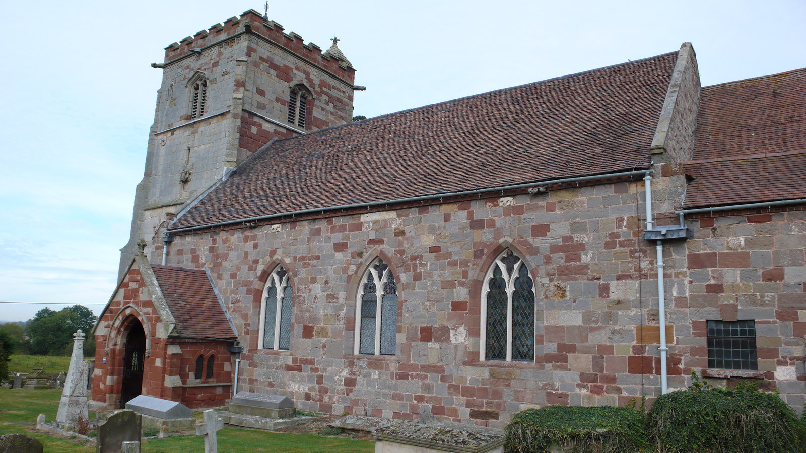
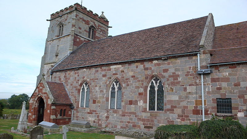
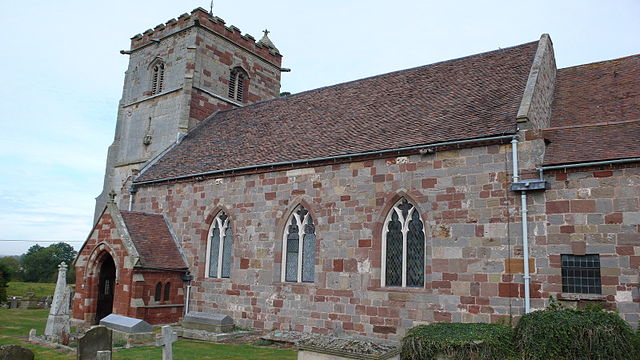
St. Andrews Church
Wroxeter, near to Wroxeter, Shropshire, Great Britain. St. Andrews church is maintained under the Redundant Churches Fund
199:
1025:
706:
670:
634:
336:
286:
756:
973:
968:
371:
65:
42:
1156:
This file contains additional information, probably added from the digital camera or scanner used to create or digitize it.
461:
984:
584:
910:
883:
846:
819:
719:
690:
618:
592:
577:
562:
777:
749:
734:
654:
535:
518:
358:
417:
1159:
If the file has been modified from its original state, some details may not fully reflect the modified file.
460:– If you remix, transform, or build upon the material, you must distribute your contributions under the
378:
on the
Geograph website for the photographer's contact details. The copyright on this image is owned by
414:
876:"}},"text\/plain":{"en":{"P7787":"292 degree"}}}}": -->
812:"}},"text\/plain":{"en":{"P7787":"292 degree"}}}}": -->
173:
114:
231:
741:
726:
569:
215:
1133:
342:
292:
1016:
List of churches preserved by the
Churches Conservation Trust in the English Midlands
383:
101:
1073:
1083:
276:
158:
326:
1124:Список церквей в Английском Мидлендсе, сохранённых Фондом сохранения церквей
169:
188:
1030:
363:
375:
941:
Click on a date/time to view the file as it appeared at that time.
1103:
328:
278:
263:
52° 40′ 11.72″ N, 2° 38′ 48.42″ W
177:
303:
253:
89:
1064:كنيسه القديس اندرو (وروكسيتير اند وپينجتون, المملكه المتحده)
139:
St. Andrews Church
Wroxeter - geograph.org.uk - 1754377.jpg
313:
52° 40′ 12″ N, 2° 38′ 50″ W
502:
Add a one-line explanation of what this file represents
1143:
1113:
1093:
206:
Creative
Commons Attribution Share-alike license 2.0
133:
113:
Commons is a freely licensed media file repository.
671:
Creative
Commons Attribution-ShareAlike 2.0 Generic
79:(1,600 × 900 pixels, file size: 392 KB, MIME type:
1046:Knowledge:Today's featured list/June 22, 2020
1041:Knowledge:Today's featured list/June 2020
471:https://creativecommons.org/licenses/by-sa/2.0
94:
477:Creative Commons Attribution-Share Alike 2.0
395:
8:
873:
809:
437:– to copy, distribute and transmit the work
1161:
1021:Listed buildings in Wroxeter and Uppington
943:
498:
1056:The following other wikis use this file:
742:https://www.geograph.org.uk/photo/1754377
1036:Knowledge:Main Page history/2020 June 22
570:https://www.geograph.org.uk/profile/2458
1163:
1003:
897:
881:
833:
817:
791:
775:
704:
688:
668:
652:
632:
616:
549:
533:
516:
513:
494:
487:
306:
256:
1074:Grade I listed buildings in Shropshire
1006:Grade I listed buildings in Shropshire
335:View this and other nearby images on:
285:View this and other nearby images on:
1011:Grade I listed churches in Shropshire
1001:The following 9 pages use this file:
7:
382:and is licensed for reuse under the
932:
418:Attribution-Share Alike 2.0 Generic
406:
401:
386:Attribution-ShareAlike 2.0 license.
1154:
507:
501:
392:
369:
143:
126:
72:
1026:St Andrew's Church, Wroxeter
506:
820:coordinates of the point of view
492:
448:Under the following conditions:
413:This file is licensed under the
405:
400:
394:
362:
341:
327:
319:
291:
277:
269:
93:
31:
21:
986:File Upload Bot (Magnus Manske)
489:
144:
14:
707:file available on the internet
488:
370:This image was taken from the
26:
1:
884:coordinates of depicted place
835:52°40'11.719"N, 2°38'48.415"W
36:
757:Geograph Britain and Ireland
578:object of statement has role
514:Items portrayed in this file
318:
268:
1070:Usage on dag.wikipedia.org
1060:Usage on arz.wikipedia.org
899:52°40'12.50"N, 2°38'50.28"W
246:St. Andrews Church Wroxeter
227:St. Andrews Church Wroxeter
1185:
1140:Usage on www.wikidata.org
1130:Usage on ur.wikipedia.org
1120:Usage on ru.wikipedia.org
1110:Usage on no.wikipedia.org
1100:Usage on nl.wikipedia.org
1090:Usage on fr.wikipedia.org
1080:Usage on fa.wikipedia.org
462:same or compatible license
933:
244:Peter Comeau /
225:Peter Comeau /
16:
720:geograph.org.uk image ID
491:
428:
100:This is a file from the
990:
216:required by the license
194:
184:
164:
157:
154:
136:
104:. Information from its
376:this photograph's page
347:52.670140; -2.647300
297:52.669922; -2.646782
174:User:Kurpfalzbilder.de
107:description page there
46:Size of this preview:
178:geograph_org2commons
1104:Wroxeter (Engeland)
443:– to adapt the work
52:Other resolutions:
969:11:11, 2 July 2010
593:author name string
66:1,600 × 900 pixels
62:1,024 × 576 pixels
1172:
1171:
1052:Global file usage
994:
875:
811:
655:copyright license
500:
391:
390:
374:collection. See
352:
351:
302:
301:
251:
250:
219:
203:
200:Reusing this file
172:; transferred by
122:
121:
102:Wikimedia Commons
32:Global file usage
1176:
1162:
981:
921:
920:
915:
857:
856:
851:
759:
754:
744:
739:
735:described at URL
729:
724:
619:copyright status
600:
597:
587:
582:
572:
567:
484:
481:
478:
475:
472:
464:as the original.
426:
415:Creative Commons
409:
408:
404:
403:
398:
397:
384:Creative Commons
372:Geograph project
366:
359:
348:
345:
331:
330:
324:
323:
322:
316:
315:
304:
298:
295:
281:
280:
274:
273:
272:
266:
265:
254:
213:
197:
160:
148:
140:
134:
118:
97:
96:
90:
84:
82:
69:
58:640 × 360 pixels
54:320 × 180 pixels
48:800 × 450 pixels
1184:
1183:
1179:
1178:
1177:
1175:
1174:
1173:
1150:
1050:
995:
987:
979:
935:
934:
931:
930:
929:
928:
927:
926:
925:
924:
923:
922:
918:
916:
913:
904:
903:
902:
900:
890:
889:
888:
886:
867:
866:
865:
864:
863:
862:
861:
860:
859:
858:
854:
852:
849:
840:
839:
838:
836:
826:
825:
824:
822:
803:
802:
801:
800:
799:
798:
797:
796:
794:
784:
783:
782:
780:
769:
768:
767:
766:
765:
764:
763:
762:
761:
760:
755:
752:
746:
745:
740:
737:
731:
730:
725:
722:
713:
712:
711:
709:
697:
696:
695:
693:
682:
681:
680:
679:
678:
677:
676:
675:
673:
661:
660:
659:
657:
646:
645:
644:
643:
642:
641:
640:
639:
637:
625:
624:
623:
621:
610:
609:
608:
607:
606:
605:
604:
603:
602:
601:
598:
595:
589:
588:
583:
580:
574:
573:
568:
565:
556:
555:
554:
552:
542:
541:
540:
538:
527:
526:
525:
524:
523:
521:
505:
504:
503:
486:
485:
482:
479:
476:
473:
470:
469:
427:
424:
421:
410:
387:
357:
346:
320:
311:
310:
307:Object location
296:
270:
261:
260:
257:Camera location
252:
241:
234:
222:
170:geograph.org.uk
150:
138:
131:
124:
123:
112:
111:
110:is shown below.
86:
80:
78:
71:
70:
51:
12:
11:
5:
1182:
1180:
1170:
1169:
1166:
1153:
1149:
1148:
1147:
1146:
1138:
1137:
1136:
1128:
1127:
1126:
1118:
1117:
1116:
1108:
1107:
1106:
1098:
1097:
1096:
1088:
1087:
1086:
1078:
1077:
1076:
1068:
1067:
1066:
1054:
1053:
1049:
1048:
1043:
1038:
1033:
1028:
1023:
1018:
1013:
1008:
999:
998:
993:
992:
989:
985:
982:
976:
971:
966:
962:
961:
958:
955:
952:
949:
946:
939:
938:
909:
908:
907:
906:
905:
901:
898:
896:
895:
894:
893:
892:
891:
887:
882:
880:
879:
878:
877:
871:
845:
844:
843:
842:
841:
837:
834:
832:
831:
830:
829:
828:
827:
823:
818:
816:
815:
814:
813:
807:
795:
793:5 October 2009
792:
790:
789:
788:
787:
786:
785:
781:
776:
774:
773:
772:
771:
770:
748:
747:
733:
732:
718:
717:
716:
715:
714:
710:
705:
703:
702:
701:
700:
699:
698:
694:
691:source of file
689:
687:
686:
685:
684:
683:
674:
669:
667:
666:
665:
664:
663:
662:
658:
653:
651:
650:
649:
648:
647:
638:
633:
631:
630:
629:
628:
627:
626:
622:
617:
615:
614:
613:
612:
611:
591:
590:
576:
575:
561:
560:
559:
558:
557:
553:
550:
548:
547:
546:
545:
544:
543:
539:
534:
532:
531:
530:
529:
528:
522:
517:
515:
512:
511:
510:
509:
508:
497:
496:
493:
490:
468:
467:
466:
465:
455:
446:
445:
444:
438:
431:You are free:
422:
412:
411:
393:
389:
388:
367:
356:
353:
350:
349:
339:
333:
308:
300:
299:
289:
283:
258:
249:
248:
242:
239:
236:
235:
230:
223:
220:
208:
207:
204:
192:
191:
186:
182:
181:
166:
162:
161:
159:5 October 2009
156:
152:
151:
141:
132:
130:
127:
125:
120:
119:
98:
88:
87:
45:
41:
40:
39:
34:
29:
24:
19:
13:
10:
9:
6:
4:
3:
2:
1181:
1167:
1164:
1160:
1157:
1151:
1145:
1142:
1141:
1139:
1135:
1132:
1131:
1129:
1125:
1122:
1121:
1119:
1115:
1112:
1111:
1109:
1105:
1102:
1101:
1099:
1095:
1092:
1091:
1089:
1085:
1082:
1081:
1079:
1075:
1072:
1071:
1069:
1065:
1062:
1061:
1059:
1058:
1057:
1051:
1047:
1044:
1042:
1039:
1037:
1034:
1032:
1029:
1027:
1024:
1022:
1019:
1017:
1014:
1012:
1009:
1007:
1004:
1002:
996:
988:
983:
977:
975:
972:
970:
967:
964:
963:
959:
956:
953:
950:
947:
945:
944:
942:
936:
912:
885:
848:
821:
779:
758:
751:
743:
736:
728:
721:
708:
692:
672:
656:
636:
620:
594:
586:
579:
571:
564:
537:
520:
474:CC BY-SA 2.0
463:
459:
456:
453:
450:
449:
447:
442:
439:
436:
433:
432:
430:
429:
423:Attribution:
419:
416:
399:
385:
381:
377:
373:
368:
365:
361:
360:
354:
344:
340:
338:
337:OpenStreetMap
334:
332:
314:
309:
305:
294:
290:
288:
287:OpenStreetMap
284:
282:
264:
259:
255:
247:
243:
238:
237:
233:
229: /
228:
224:
217:
212:
210:
209:
205:
201:
196:
193:
190:
187:
183:
179:
175:
171:
167:
163:
153:
147:
142:
135:
128:
116:
109:
108:
103:
99:
92:
91:
85:
76:
75:Original file
67:
63:
59:
55:
49:
44:
38:
35:
33:
30:
28:
25:
23:
20:
18:
15:
1158:
1155:
1055:
1000:
978:1,600 × 900
940:
937:File history
599:Peter Comeau
585:photographer
457:
451:
440:
434:
425:Peter Comeau
380:Peter Comeau
379:
317:
267:
245:
232:CC BY-SA 2.0
226:
189:Peter Comeau
145:
115:You can help
105:
73:
22:File history
635:copyrighted
458:share alike
452:attribution
211:Attribution
137:Description
1165:_error
997:File usage
954:Dimensions
551:some value
195:Permission
81:image/jpeg
27:File usage
951:Thumbnail
948:Date/Time
778:inception
355:Licensing
240:InfoField
221:InfoField
146:English:
1152:Metadata
1144:Q7592382
1114:Wroxeter
1094:Wroxeter
1031:Wroxeter
980:(392 KB)
750:operator
495:Captions
441:to remix
435:to share
420:license.
37:Metadata
1134:روکسیٹر
965:current
960:Comment
911:heading
870:heading
847:heading
806:heading
727:1754377
536:creator
519:depicts
499:English
129:Summary
77:
1084:راکستر
919:degree
874:degree
855:degree
810:degree
325:
275:
185:Author
176:using
165:Source
168:From
957:User
917:292
853:292
483:true
480:true
155:Date
17:File
563:URL
914::
850::
753::
738::
723::
596::
581::
566::
64:|
60:|
56:|
50:.
1168:0
218:)
214:(
202:)
198:(
180:.
117:.
83:)
68:.
Text is available under the Creative Commons Attribution-ShareAlike License. Additional terms may apply.
_region:GB-EAW_heading:292.00&language=en)