259:
137:
43:
286:
300:
225:
99:
554:
191:
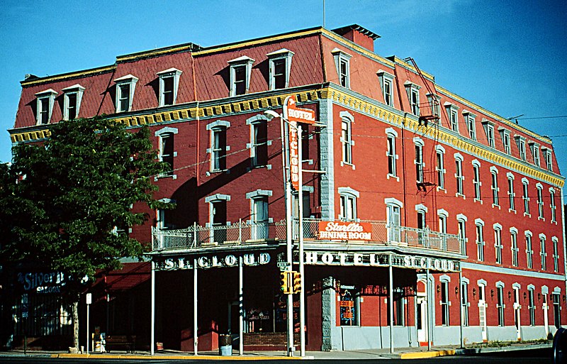
this hotel is under restoration. www.hotelstcloud.com it has received over 3 grants and is under repair managed by The Future of
Yesterday Foundation an 501c3 please visit us on facebook or our website for further details of restoration.
599:
575:'s National Historic District, the St. Cloud Hotel has stood at the corner of 6th and Main since 1888. The hotel is undergoing restoration with the help of the State Historical Fund of the Colorado Historical Society.
277:
186:
Source is inncorrect at the current moment. I have contacted the website Admins of the source and have asked them to correct it to. I am knowledged of this because i work across from the abandoned hotel.
594:
240:
232:
144:
236:
65:
61:
57:
53:
47:
110:
78:
428:
293:
174:'s National Historic District, the St. Cloud Hotel has stood at the corner of 7th and Main since 1888 and is now in disrepair.
357:
640:
This file contains additional information, probably added from the digital camera or scanner used to create or digitize it.
393:
499:
483:
449:
406:
377:
421:
341:
413:
171:
643:
If the file has been modified from its original state, some details may not fully reflect the modified file.
589:
572:
585:
The following pages on the
English Knowledge (XXG) use this file (pages on other projects are not listed):
118:
553:
548:
69:
42:
564:
299:
245:
153:
105:
283:
131:
181:
600:
National
Register of Historic Places listings in Fremont County, Colorado
235:* employee, taken or made as part of that person's official duties. As a
617:
521:
Click on a date/time to view the file as it appeared at that time.
442:
148:
285:
268:
219:
143:
This is an image of a place or building that is listed on the
93:
627:
257:
278:
38° 26′ 29″ N, 105° 14′ 17″ W
325:
Add a one-line explanation of what this file represents
83:(2,655 × 1,702 pixels, file size: 904 KB, MIME type:
117:
Commons is a freely licensed media file repository.
429:
work of the federal government of the United States
98:
8:
182:http://www.fhwa.dot.gov/byways/photos/26640
645:
523:
321:
199:
610:The following other wikis use this file:
177:Photo credit: Bureau of Land Management
647:
587:
497:
481:
463:
447:
391:
375:
355:
339:
336:
317:
310:
271:
292:View this and other nearby images on:
595:Cañon City Downtown Historic District
358:Cañon City Downtown Historic District
224:
7:
145:National Register of Historic Places
512:
638:
330:
324:
130:
76:
329:
315:
298:
284:
223:
135:
97:
31:
21:
465:38°26'29.000"N, 105°14'17.002"W
312:
14:
311:
26:
1:
450:coordinates of depicted place
36:
337:Items portrayed in this file
253:*or predecessor organization
669:
624:Usage on de.wikipedia.org
614:Usage on cy.wikipedia.org
231:This image is a work of a
151:. Its reference number is
513:
233:Bureau of Land Management
16:
414:United States of America
314:
149:United States of America
104:This is a file from the
570:
407:applies to jurisdiction
241:U.S. federal government
108:. Information from its
573:w:Cañon City, Colorado
304:38.441389; -105.238056
262:
243:, the image is in the
172:w:Cañon City, Colorado
111:description page there
46:Size of this preview:
261:
249:in the United States.
618:Cañon City, Colorado
590:Cañon City, Colorado
484:location of creation
422:determination method
70:2,655 × 1,702 pixels
549:16:38, 4 April 2006
52:Other resolutions:
263:
66:1,280 × 821 pixels
62:1,024 × 656 pixels
656:
655:
606:Global file usage
578:
323:
309:
308:
267:
266:
218:
217:
163:
162:
126:
125:
106:Wikimedia Commons
32:Global file usage
660:
646:
561:
431:
426:
416:
411:
378:copyright status
305:
302:
288:
287:
281:
280:
269:
260:
254:
227:
226:
220:
214:
211:
208:
205:
200:
156:
139:
138:
132:
122:
101:
100:
94:
88:
86:
73:
58:640 × 410 pixels
54:320 × 205 pixels
48:800 × 513 pixels
668:
667:
663:
662:
661:
659:
658:
657:
634:
604:
586:
579:
567:
559:
515:
514:
511:
510:
509:
508:
507:
506:
505:
504:
502:
490:
489:
488:
486:
475:
474:
473:
472:
471:
470:
469:
468:
466:
456:
455:
454:
452:
441:
440:
439:
438:
437:
436:
435:
434:
433:
432:
427:
424:
418:
417:
412:
409:
400:
399:
398:
396:
384:
383:
382:
380:
369:
368:
367:
366:
365:
364:
363:
362:
360:
348:
347:
346:
344:
328:
327:
326:
303:
276:
275:
272:Object location
258:
252:
212:
209:
206:
203:
198:
168:
152:
136:
128:
127:
116:
115:
114:is shown below.
90:
84:
82:
75:
74:
51:
12:
11:
5:
666:
664:
654:
653:
650:
637:
633:
632:
631:
630:
622:
621:
620:
608:
607:
603:
602:
597:
592:
584:
583:
582:
577:
576:
569:
565:
562:
558:2,655 × 1,702
556:
551:
546:
542:
541:
538:
535:
532:
529:
526:
519:
518:
503:
498:
496:
495:
494:
493:
492:
491:
487:
482:
480:
479:
478:
477:
476:
467:
464:
462:
461:
460:
459:
458:
457:
453:
448:
446:
445:
444:
443:
420:
419:
405:
404:
403:
402:
401:
397:
392:
390:
389:
388:
387:
386:
385:
381:
376:
374:
373:
372:
371:
370:
361:
356:
354:
353:
352:
351:
350:
349:
345:
340:
338:
335:
334:
333:
332:
331:
320:
319:
316:
313:
307:
306:
296:
290:
273:
265:
264:
255:
228:
216:
215:
197:
194:
167:
164:
161:
160:
140:
129:
124:
123:
102:
92:
91:
45:
41:
40:
39:
34:
29:
24:
19:
13:
10:
9:
6:
4:
3:
2:
665:
651:
648:
644:
641:
635:
629:
626:
625:
623:
619:
616:
615:
613:
612:
611:
605:
601:
598:
596:
593:
591:
588:
580:
574:
568:
563:
557:
555:
552:
550:
547:
544:
543:
539:
536:
533:
530:
527:
525:
524:
522:
516:
501:
485:
451:
430:
423:
415:
408:
395:
394:public domain
379:
359:
343:
301:
297:
295:
294:OpenStreetMap
291:
289:
279:
274:
270:
256:
251:
250:
248:
247:
246:public domain
242:
238:
234:
229:
222:
221:
207:Public domain
204:Public domain
202:
201:
195:
193:
190:
188:
184:
183:
178:
175:
173:
165:
159:
158:
155:
150:
146:
141:
134:
133:
120:
113:
112:
107:
103:
96:
95:
89:
80:
79:Original file
71:
67:
63:
59:
55:
49:
44:
38:
35:
33:
30:
28:
25:
23:
20:
18:
15:
642:
639:
609:
520:
517:File history
244:
230:
189:
185:
179:
176:
169:
142:
119:You can help
109:
77:
22:File history
571:Located in
566:Holly Cheng
170:Located in
649:_error
628:Cañon City
581:File usage
534:Dimensions
85:image/jpeg
27:File usage
531:Thumbnail
528:Date/Time
196:Licensing
636:Metadata
560:(904 KB)
500:Colorado
318:Captions
180:Source:
154:83003517
37:Metadata
545:current
540:Comment
342:depicts
322:English
239:of the
166:Summary
147:in the
81:
282:
213:false
210:false
537:User
237:work
17:File
425::
410::
68:|
64:|
60:|
56:|
50:.
652:0
157:.
121:.
87:)
72:.
Text is available under the Creative Commons Attribution-ShareAlike License. Additional terms may apply.
