296:
226:
240:
264:
302:
307:
72:
992:
43:
217:
1009:== {{int:filedesc}} == {{Information |description={{en|1=St Andrew's Church, Nuthurst, West Sussex. Parts of St Andrew's Church date back to the 12th century, namely the north chancel wall. The nave was built in the 14th century and extended in the 17th c
128:
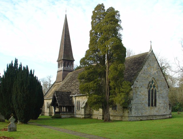
There has been worship on this site since about AD 1130. The north chancel wall is 12th-century. The nave was built in the 14th century and extended in the 17th century. The wooden shingled spire was built in the late 19th-century. The vestry was added in about
51:
83:
354:– You must give appropriate credit, provide a link to the license, and indicate if changes were made. You may do so in any reasonable manner, but not in any way that suggests the licensor endorses you or your use.
1023:
991:
986:
42:
640:
570:
534:
233:
660:
1181:
271:
1054:
This file contains additional information, probably added from the digital camera or scanner used to create or digitize it.
937:
361:
497:
887:
853:
816:
782:
745:
711:
668:
624:
518:
490:
477:
462:
683:
653:
590:
554:
435:
418:
921:
258:
317:
1057:
If the file has been modified from its original state, some details may not fully reflect the modified file.
1208:
360:– If you remix, transform, or build upon the material, you must distribute your contributions under the
278:
on the
Geograph website for the photographer's contact details. The copyright on this image is owned by
1002:
314:
1244:
91:
186:
469:
170:
690:
675:
239:
1280:
1226:
1083:
283:
78:
1123:
1254:
138:
1103:
223:
159:
52:
St_Andrew's_Church,_Nuthurst,_West_Sussex_-_geograph.org.uk_-_86085.jpg
149:
126:
St Andrew's parish church, Nuthurst, West Sussex, seen from the southeast.
1093:
263:
116:
St Andrew's Church, Nuthurst, West Sussex - geograph.org.uk - 86085.jpg
1076:
275:
959:
Click on a date/time to view the file as it appeared at that time.
1066:
225:
208:
66:
704:
218:
51° 01′ 21″ N, 0° 18′ 04″ W
402:
Add a one-line explanation of what this file represents
1041:
110:
90:
Commons is a freely licensed media file repository.
571:
Creative
Commons Attribution-ShareAlike 2.0 Generic
56:(640 × 485 pixels, file size: 126 KB, MIME type:
371:https://creativecommons.org/licenses/by-sa/2.0
71:
1024:List of places of worship in Horsham District
377:Creative Commons Attribution-Share Alike 2.0
295:
8:
337:– to copy, distribute and transmit the work
1059:
961:
398:
1034:The following other wikis use this file:
201:St Andrew's Church, Nuthurst, West Sussex
182:St Andrew's Church, Nuthurst, West Sussex
470:https://www.geograph.org.uk/profile/1024
1288:
1278:
1270:
1262:
1252:
1242:
1234:
1224:
1216:
1206:
1198:
1190:
1179:
1171:
1163:
1155:
1147:
1139:
1131:
1120:
1112:
1101:
1091:
1081:
1071:
1021:
935:
919:
901:
885:
867:
851:
830:
814:
796:
780:
759:
743:
725:
709:
691:https://www.geograph.org.uk/photo/86085
638:
622:
604:
588:
568:
552:
532:
516:
449:
433:
416:
413:
394:
387:
211:
232:View this and other nearby images on:
1061:
7:
282:and is licensed for reuse under the
1019:The following page uses this file:
950:
318:Attribution-Share Alike 2.0 Generic
306:
301:
286:Attribution-ShareAlike 2.0 license.
1052:
407:
401:
292:
269:
120:
103:
49:
406:
1114:Date and time of data generation
392:
348:Under the following conditions:
313:This file is licensed under the
305:
300:
294:
262:
238:
224:
70:
31:
21:
389:
121:
46:No higher resolution available.
14:
641:file available on the internet
388:
270:This image was taken from the
26:
1:
712:coordinates of depicted place
36:
661:Geograph Britain and Ireland
491:object of statement has role
414:Items portrayed in this file
1192:Date and time of digitizing
1310:
1038:Usage on nl.wikipedia.org
362:same or compatible license
1157:File change date and time
951:
199:Pete Chapman /
180:Pete Chapman /
16:
669:geograph.org.uk image ID
391:
328:
77:This is a file from the
1264:Custom image processing
1231:Center weighted average
1195:13:54, 30 November 2005
1160:22:59, 30 November 2005
1117:13:54, 30 November 2005
1008:
727:51°1'20.6"N, 0°18'3.6"W
171:required by the license
155:
144:
137:
134:
113:
81:. Information from its
1200:Image compression mode
987:23:50, 30 January 2010
276:this photograph's page
244:51.022400; -0.301000
84:description page there
1218:Maximum land aperture
1141:Horizontal resolution
1165:Y and C positioning
1149:Vertical resolution
1063:Camera manufacturer
343:– to adapt the work
1290:Scene capture type
1285:Auto white balance
1249:Flash did not fire
478:author name string
1297:
1296:
1176:Aperture priority
1088:1/80 sec (0.0125)
1030:Global file usage
1012:
555:copyright license
400:
291:
290:
274:collection. See
249:
248:
206:
205:
174:
99:
98:
79:Wikimedia Commons
32:Global file usage
1301:
1173:Exposure Program
1060:
999:
835:
764:
693:
688:
684:described at URL
678:
673:
663:
658:
606:30 November 2005
519:copyright status
500:
495:
485:
482:
472:
467:
384:
381:
378:
375:
372:
364:as the original.
326:
315:Creative Commons
309:
308:
304:
303:
298:
297:
284:Creative Commons
272:Geograph project
266:
259:
245:
242:
228:
227:
221:
220:
209:
168:
140:
139:30 November 2005
125:
117:
111:
95:
74:
73:
67:
61:
59:
1309:
1308:
1304:
1303:
1302:
1300:
1299:
1298:
1275:Manual exposure
1221:3 APEX (f/2.83)
1048:
1028:
1013:
1005:
997:
953:
952:
949:
948:
947:
946:
945:
944:
943:
942:
940:
928:
927:
926:
924:
913:
912:
911:
910:
909:
908:
907:
906:
904:
894:
893:
892:
890:
879:
878:
877:
876:
875:
874:
873:
872:
870:
860:
859:
858:
856:
845:
844:
843:
842:
841:
840:
839:
838:
836:
833:
823:
822:
821:
819:
808:
807:
806:
805:
804:
803:
802:
801:
799:
789:
788:
787:
785:
774:
773:
772:
771:
770:
769:
768:
767:
765:
762:
752:
751:
750:
748:
737:
736:
735:
734:
733:
732:
731:
730:
728:
718:
717:
716:
714:
703:
702:
701:
700:
699:
698:
697:
696:
695:
694:
689:
686:
680:
679:
674:
671:
665:
664:
659:
656:
647:
646:
645:
643:
631:
630:
629:
627:
616:
615:
614:
613:
612:
611:
610:
609:
607:
597:
596:
595:
593:
582:
581:
580:
579:
578:
577:
576:
575:
573:
561:
560:
559:
557:
546:
545:
544:
543:
542:
541:
540:
539:
537:
525:
524:
523:
521:
510:
509:
508:
507:
506:
505:
504:
503:
502:
501:
496:
493:
487:
486:
483:
480:
474:
473:
468:
465:
456:
455:
454:
452:
442:
441:
440:
438:
427:
426:
425:
424:
423:
421:
405:
404:
403:
386:
385:
382:
379:
376:
373:
370:
369:
327:
324:
321:
310:
287:
257:
243:
216:
215:
212:Object location
207:
196:
189:
177:
150:geograph.org.uk
130:
115:
108:
101:
100:
89:
88:
87:is shown below.
63:
57:
55:
48:
47:
12:
11:
5:
1307:
1305:
1295:
1294:
1291:
1287:
1286:
1283:
1277:
1276:
1273:
1269:
1268:
1267:Normal process
1265:
1261:
1260:
1257:
1251:
1250:
1247:
1241:
1240:
1237:
1233:
1232:
1229:
1223:
1222:
1219:
1215:
1214:
1211:
1205:
1204:
1201:
1197:
1196:
1193:
1189:
1188:
1185:
1178:
1177:
1174:
1170:
1169:
1166:
1162:
1161:
1158:
1154:
1153:
1150:
1146:
1145:
1142:
1138:
1137:
1134:
1130:
1129:
1126:
1119:
1118:
1115:
1111:
1110:
1107:
1100:
1099:
1096:
1090:
1089:
1086:
1080:
1079:
1074:
1070:
1069:
1064:
1051:
1047:
1046:
1045:
1044:
1032:
1031:
1027:
1026:
1017:
1016:
1011:
1010:
1007:
1003:
1000:
994:
989:
984:
980:
979:
976:
973:
970:
967:
964:
957:
956:
941:
936:
934:
933:
932:
931:
930:
929:
925:
920:
918:
917:
916:
915:
914:
905:
902:
900:
899:
898:
897:
896:
895:
891:
886:
884:
883:
882:
881:
880:
871:
868:
866:
865:
864:
863:
862:
861:
857:
852:
850:
849:
848:
847:
846:
837:
831:
829:
828:
827:
826:
825:
824:
820:
815:
813:
812:
811:
810:
809:
800:
797:
795:
794:
793:
792:
791:
790:
786:
781:
779:
778:
777:
776:
775:
766:
760:
758:
757:
756:
755:
754:
753:
749:
744:
742:
741:
740:
739:
738:
729:
726:
724:
723:
722:
721:
720:
719:
715:
710:
708:
707:
706:
705:
682:
681:
667:
666:
652:
651:
650:
649:
648:
644:
639:
637:
636:
635:
634:
633:
632:
628:
625:source of file
623:
621:
620:
619:
618:
617:
608:
605:
603:
602:
601:
600:
599:
598:
594:
589:
587:
586:
585:
584:
583:
574:
569:
567:
566:
565:
564:
563:
562:
558:
553:
551:
550:
549:
548:
547:
538:
533:
531:
530:
529:
528:
527:
526:
522:
517:
515:
514:
513:
512:
511:
489:
488:
476:
475:
461:
460:
459:
458:
457:
453:
450:
448:
447:
446:
445:
444:
443:
439:
434:
432:
431:
430:
429:
428:
422:
417:
415:
412:
411:
410:
409:
408:
397:
396:
393:
390:
368:
367:
366:
365:
355:
346:
345:
344:
338:
331:You are free:
322:
312:
311:
293:
289:
288:
267:
256:
253:
247:
246:
236:
230:
213:
204:
203:
197:
194:
191:
190:
185:
178:
175:
163:
162:
157:
153:
152:
146:
142:
141:
136:
132:
131:
118:
109:
107:
104:
102:
97:
96:
75:
65:
64:
45:
41:
40:
39:
34:
29:
24:
19:
13:
10:
9:
6:
4:
3:
2:
1306:
1292:
1289:
1284:
1282:
1281:White balance
1279:
1274:
1272:Exposure mode
1271:
1266:
1263:
1258:
1256:
1253:
1248:
1246:
1243:
1238:
1235:
1230:
1228:
1227:Metering mode
1225:
1220:
1217:
1212:
1210:
1209:Exposure bias
1207:
1202:
1199:
1194:
1191:
1186:
1183:
1180:
1175:
1172:
1167:
1164:
1159:
1156:
1151:
1148:
1143:
1140:
1135:
1132:
1127:
1125:
1121:
1116:
1113:
1108:
1105:
1102:
1097:
1095:
1092:
1087:
1085:
1084:Exposure time
1082:
1078:
1075:
1072:
1068:
1065:
1062:
1058:
1055:
1049:
1043:
1040:
1039:
1037:
1036:
1035:
1029:
1025:
1022:
1020:
1014:
1006:
1001:
995:
993:
990:
988:
985:
982:
981:
977:
974:
971:
968:
965:
963:
962:
960:
954:
939:
923:
889:
855:
818:
784:
747:
746:exposure time
713:
692:
685:
677:
670:
662:
655:
642:
626:
592:
572:
556:
536:
520:
499:
492:
479:
471:
464:
437:
420:
374:CC BY-SA 2.0
363:
359:
356:
353:
350:
349:
347:
342:
339:
336:
333:
332:
330:
329:
323:Attribution:
319:
316:
299:
285:
281:
277:
273:
268:
265:
261:
260:
254:
252:
251:
241:
237:
235:
234:OpenStreetMap
231:
229:
219:
214:
210:
202:
198:
193:
192:
188:
184: /
183:
179:
172:
167:
165:
164:
161:
158:
154:
151:
147:
143:
133:
127:
124:
119:
112:
105:
93:
86:
85:
80:
76:
69:
68:
62:
53:
44:
38:
35:
33:
30:
28:
25:
23:
20:
18:
15:
1236:Light source
1124:focal length
1073:Camera model
1056:
1053:
1033:
1018:
958:
955:File history
817:focal length
498:photographer
484:Pete Chapman
357:
351:
340:
334:
325:Pete Chapman
280:Pete Chapman
279:
250:
200:
187:CC BY-SA 2.0
181:
160:Pete Chapman
122:
92:You can help
82:
50:
22:File history
1255:Color space
1133:Orientation
1004:GeographBot
922:instance of
535:copyrighted
358:share alike
352:attribution
166:Attribution
114:Description
1015:File usage
996:640 × 485
972:Dimensions
938:photograph
903:image/jpeg
888:media type
834:millimetre
451:some value
58:image/jpeg
27:File usage
1104:ISO speed
969:Thumbnail
966:Date/Time
854:ISO speed
591:inception
255:Licensing
195:InfoField
176:InfoField
123:English:
1293:Standard
1168:Co-sited
1094:F-number
1050:Metadata
1042:Nuthurst
998:(126 KB)
783:f-number
654:operator
395:Captions
341:to remix
335:to share
320:license.
37:Metadata
1239:Unknown
1184:version
983:current
978:Comment
761:0.0125
436:creator
419:depicts
399:English
106:Summary
54:
1152:72 dpi
1144:72 dpi
1136:Normal
1106:rating
1077:DSC-V1
763:second
222:
156:Author
145:Source
1245:Flash
1122:Lens
1098:f/6.3
676:86085
148:From
129:1907.
1259:sRGB
1182:Exif
1128:7 mm
1067:SONY
975:User
383:true
380:true
135:Date
17:File
1213:0.3
1187:2.2
1109:100
869:100
798:6.3
463:URL
832:7
687::
672::
657::
494::
481::
466::
1203:4
173:)
169:(
94:.
60:)
Text is available under the Creative Commons Attribution-ShareAlike License. Additional terms may apply.
_&language=en)
