327:
260:
252:
274:
295:
333:
338:
72:
562:"}},"text\/plain":{"en":{"":"heading"}}},"{\"value\":{\"amount\":\"+135.0\",\"unit\":\"http:\\\/\\\/www.wikidata.org\\\/entity\\\/Q28390\"},\"type\":\"quantity\"}":{"text\/html":{"en":{"P7787":"135.0
558:
43:
385:– You must give appropriate credit, provide a link to the license, and indicate if changes were made. You may do so in any reasonable manner, but not in any way that suggests the licensor endorses you or your use.
243:
559:
716:
83:
51:
178:
545:
509:
267:
302:
783:
This file contains additional information, probably added from the digital camera or scanner used to create or digitize it.
392:
600:
573:
493:
629:
529:
476:
289:
770:
348:
786:
If the file has been modified from its original state, some details may not fully reflect the modified file.
765:
697:
692:
42:
733:
The following pages on the
English Knowledge (XXG) use this file (pages on other projects are not listed):
391:– If you remix, transform, or build upon the material, you must distribute your contributions under the
309:
on the
Geograph website for the photographer's contact details. The copyright on this image is owned by
708:
566:"}},"text\/plain":{"en":{"P7787":"135.0 degree"}}}}": -->
345:
91:
212:
742:
720:
196:
436:
273:
127:
314:
78:
737:
257:
131:
146:
747:
185:
167:
156:
135:
294:
306:
665:
Click on a date/time to view the file as it appeared at that time.
259:
244:
56° 22′ 07.41″ N, 2° 50′ 30.92″ W
234:
66:
460:
Add a one-line explanation of what this file represents
428:
441:
Uploading a file from a free published source using ]
110:
90:
Commons is a freely licensed media file repository.
717:
w:File:St
Andrews Links & Town from the air.jpg
546:
Creative
Commons Attribution-ShareAlike 2.0 Generic
431:. All following user names refer to en.wikipedia.
56:(635 × 394 pixels, file size: 69 KB, MIME type:
402:https://creativecommons.org/licenses/by-sa/2.0
71:
408:Creative Commons Attribution-Share Alike 2.0
326:
8:
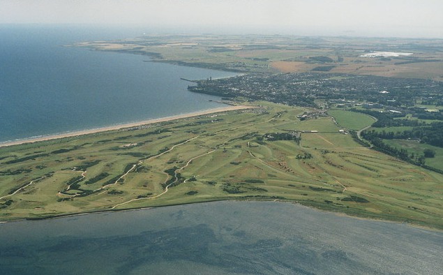
227:St.Andrews town and golf course 2007, aerial
208:St.Andrews town and golf course 2007, aerial
116:St Andrews Links & Town from the air.jpg
52:St_Andrews_Links_&_Town_from_the_air.jpg
563:
368:– to copy, distribute and transmit the work
788:
667:
456:
758:The following other wikis use this file:
186:https://www.geograph.org.uk/photo/3146025
168:https://www.geograph.org.uk/profile/79357
157:https://www.geograph.org.uk/photo/3146025
790:
735:
643:
627:
587:
571:
543:
527:
507:
491:
474:
471:
452:
445:
237:
266:View this and other nearby images on:
7:
313:and is licensed for reuse under the
656:
349:Attribution-Share Alike 2.0 Generic
337:
332:
317:Attribution-ShareAlike 2.0 license.
781:
465:
459:
427:The original description page was
426:
323:
300:
120:
103:
49:
464:
574:coordinates of the point of view
450:
379:Under the following conditions:
344:This file is licensed under the
336:
331:
325:
293:
272:
258:
250:
70:
31:
21:
447:
121:
46:No higher resolution available.
14:
446:
301:This image was taken from the
26:
1:
36:
589:56°22'7.410"N, 2°50'30.919"W
472:Items portrayed in this file
249:
812:
762:Usage on zh.wikipedia.org
393:same or compatible license
657:
16:
449:
359:
77:This is a file from the
714:
439:635×394× (70882 bytes)
197:required by the license
173:
162:
152:
145:
142:
113:
81:. Information from its
307:this photograph's page
278:56.368725; -2.841922
84:description page there
423:Original upload log
374:– to adapt the work
126:Aerial view of the
693:08:28, 23 May 2014
225:Chris /
206:Chris /
799:
798:
795:Created with GIMP
792:JPEG file comment
754:Global file usage
726:
565:
530:copyright license
458:
435:2013-06-01 09:17
322:
321:
305:collection. See
283:
282:
232:
231:
200:
182:
179:Reusing this file
99:
98:
79:Wikimedia Commons
32:Global file usage
803:
789:
743:St Andrews Links
705:
611:
610:
605:
494:copyright status
415:
412:
409:
406:
403:
395:as the original.
357:
346:Creative Commons
340:
339:
335:
334:
329:
328:
315:Creative Commons
303:Geograph project
297:
290:
279:
276:
262:
261:
255:
254:
253:
247:
246:
235:
194:
176:
148:
125:
117:
111:
95:
74:
73:
67:
61:
59:
811:
810:
806:
805:
804:
802:
801:
800:
777:
752:
734:
727:
711:
703:
659:
658:
655:
654:
653:
652:
651:
650:
649:
648:
646:
636:
635:
634:
632:
621:
620:
619:
618:
617:
616:
615:
614:
613:
612:
608:
606:
603:
594:
593:
592:
590:
580:
579:
578:
576:
557:
556:
555:
554:
553:
552:
551:
550:
548:
536:
535:
534:
532:
521:
520:
519:
518:
517:
516:
515:
514:
512:
500:
499:
498:
496:
485:
484:
483:
482:
481:
479:
463:
462:
461:
432:
425:
417:
416:
413:
410:
407:
404:
401:
400:
358:
355:
352:
341:
318:
288:
277:
251:
242:
241:
238:Camera location
233:
222:
215:
203:
138:
115:
108:
101:
100:
89:
88:
87:is shown below.
63:
57:
55:
48:
47:
12:
11:
5:
809:
807:
797:
796:
793:
780:
776:
775:
774:
773:
768:
756:
755:
751:
750:
745:
740:
732:
731:
730:
725:
724:
713:
709:
706:
700:
695:
690:
686:
685:
682:
679:
676:
673:
670:
663:
662:
647:
644:
642:
641:
640:
639:
638:
637:
633:
628:
626:
625:
624:
623:
622:
599:
598:
597:
596:
595:
591:
588:
586:
585:
584:
583:
582:
581:
577:
572:
570:
569:
568:
567:
561:
549:
544:
542:
541:
540:
539:
538:
537:
533:
528:
526:
525:
524:
523:
522:
513:
508:
506:
505:
504:
503:
502:
501:
497:
492:
490:
489:
488:
487:
486:
480:
475:
473:
470:
469:
468:
467:
466:
455:
454:
451:
448:
444:
443:
424:
421:
399:
398:
397:
396:
386:
377:
376:
375:
369:
362:You are free:
353:
343:
342:
324:
320:
319:
298:
287:
284:
281:
280:
270:
264:
239:
230:
229:
223:
220:
217:
216:
211:
204:
201:
189:
188:
183:
171:
170:
164:
160:
159:
154:
150:
149:
144:
140:
139:
118:
109:
107:
104:
102:
97:
96:
75:
65:
64:
45:
41:
40:
39:
34:
29:
24:
19:
13:
10:
9:
6:
4:
3:
2:
808:
794:
791:
787:
784:
778:
772:
769:
767:
764:
763:
761:
760:
759:
753:
749:
746:
744:
741:
739:
736:
728:
722:
718:
712:
707:
701:
699:
696:
694:
691:
688:
687:
683:
680:
677:
674:
671:
669:
668:
666:
660:
645:9 August 2007
631:
602:
575:
547:
531:
511:
495:
478:
442:
438:
434:
433:
430:
422:
420:
419:
405:CC BY-SA 2.0
394:
390:
387:
384:
381:
380:
378:
373:
370:
367:
364:
363:
361:
360:
354:Attribution:
350:
347:
330:
316:
312:
308:
304:
299:
296:
292:
291:
285:
275:
271:
269:
268:OpenStreetMap
265:
263:
245:
240:
236:
228:
224:
219:
218:
214:
210: /
209:
205:
198:
193:
191:
190:
187:
184:
180:
175:
172:
169:
165:
161:
158:
155:
151:
147:9 August 2007
141:
137:
133:
129:
124:
119:
112:
105:
93:
86:
85:
80:
76:
69:
68:
62:
53:
44:
38:
35:
33:
30:
28:
25:
23:
20:
18:
15:
785:
782:
771:Talk:聖安德魯林克斯
757:
738:Links (golf)
710:FastilyClone
664:
661:File history
440:
418:
388:
382:
371:
365:
310:
248:
226:
213:CC BY-SA 2.0
207:
130:and town of
122:
92:You can help
82:
50:
22:File history
510:copyrighted
389:share alike
383:attribution
192:Attribution
114:Description
748:Talk:Leith
729:File usage
702:635 × 394
678:Dimensions
174:Permission
132:St Andrews
58:image/jpeg
27:File usage
675:Thumbnail
672:Date/Time
630:inception
437:WhaleyTim
286:Licensing
221:InfoField
202:InfoField
123:English:
779:Metadata
453:Captions
372:to remix
366:to share
351:license.
136:Scotland
37:Metadata
766:聖安德魯林克斯
704:(69 KB)
689:current
684:Comment
601:heading
560:heading
477:depicts
457:English
166:Chris
106:Summary
54:
609:degree
607:135.0
564:degree
256:
163:Author
153:Source
715:from
356:Chris
311:Chris
128:links
681:User
429:here
414:true
411:true
143:Date
17:File
721:CM
604::
134:,
723:)
719:(
199:)
195:(
181:)
177:(
94:.
60:)
Text is available under the Creative Commons Attribution-ShareAlike License. Additional terms may apply.
