141:
started from Leeds with
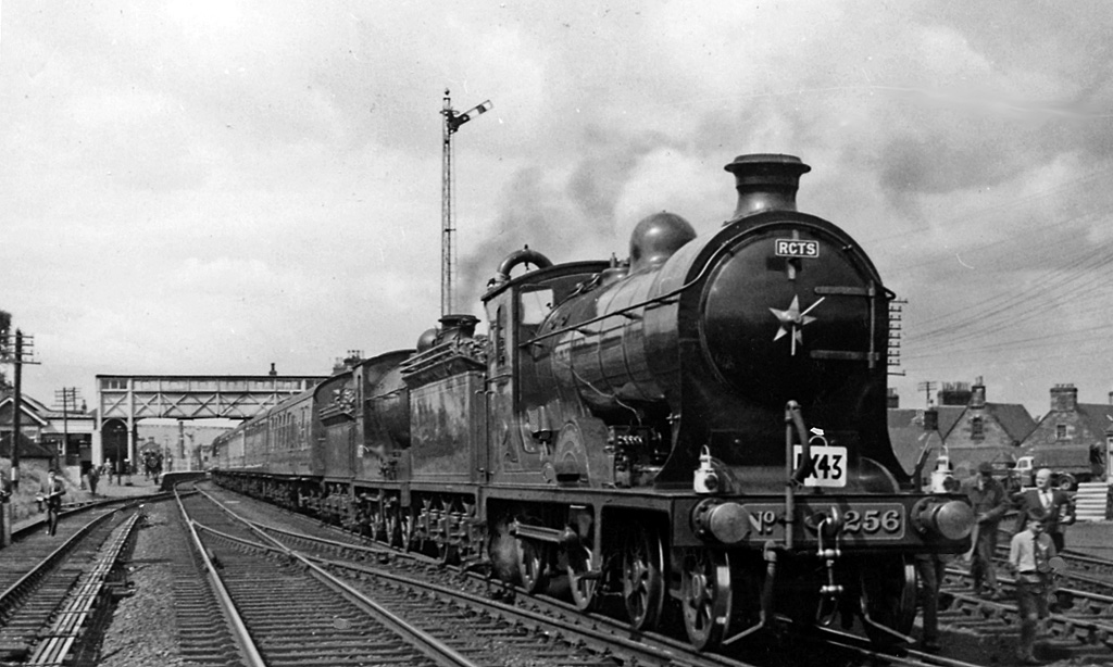
Stanier 'Duchess' Pacific No. 46247 'City of Liverpool', which took us over the Settle & Carlisle Line to Carlisle. From there we took the Waverley Route to St Boswells, thence on the Reston line (truncated since the 1948 floods), to Greenlaw, back to St Boswells, then to Jedburgh and back to Roxburgh, where we reversed once again and continued to Tweedmouth. From there we came up the ECML to Newcastle with A1 Pacific 60143 'Sir Walter Scot', finally with A3 Pacific 60074 'Harvester' via Darlington, Northallerton and Harrogate back to Leeds - a journey of 12 hours. The two NB locomotives here, are D34 'Glen' 4-4-0 No. 256 (LNER 62469) 'Glen Douglas' and J37 0-6-0 No. 64624, which hauled the Special between Carlisle and Tweedmouth. The 'Glen' had been withdrawn from normal service in 8/59 but was restored to NBR livery and used for Special Workings until 12/62; it resided until 1992 at the Glasgow Transport Museum and is currently exhibited at the Scottish Railway Exhibition at Bo'ness.
255:
372:
364:
43:
386:
223:
261:
266:
87:
615:"}},"text\/plain":{"en":{"":"heading"}}},"{\"value\":{\"amount\":\"+337\",\"unit\":\"http:\\\/\\\/www.wikidata.org\\\/entity\\\/Q28390\"},\"type\":\"quantity\"}":{"text\/html":{"en":{"P7787":"337
611:
140:
View northward, towards
Galashiels and Edinburgh on the ex-North British Waverley Line (Edinburgh - Carlisle) and towards Greenlaw and Reston on the branch to Reston (Greenlaw since 1948). This was an elaborate grand 'Borders Rail Tour' organised by the Railway Correspondence & Travel Society. We
855:{{Information |Description ={{en|1='''A Rail Tour train at St Boswells Station in 1961.'''<br/> View northward, towards Galashiels and Edinburgh on the ex-North British Waverley Line (Edinburgh - Carlisle) and towards Greenlaw and Reston on the bran...
355:
313:– You must give appropriate credit, provide a link to the license, and indicate if changes were made. You may do so in any reasonable manner, but not in any way that suggests the licensor endorses you or your use.
53:
47:
98:
66:
612:
970:
698:
598:
562:
379:
718:
443:
230:
920:
This file contains additional information, probably added from the digital camera or scanner used to create or digitize it.
837:
832:
57:
42:
320:
525:
869:
741:
682:
653:
626:
546:
518:
505:
490:
769:
726:
711:
582:
463:
427:
217:
276:
923:
If the file has been modified from its original state, some details may not fully reflect the modified file.
865:
The following pages on the
English Knowledge (XXG) use this file (pages on other projects are not listed):
848:
319:– If you remix, transform, or build upon the material, you must distribute your contributions under the
237:
on the
Geograph website for the photographer's contact details. The copyright on this image is owned by
273:
619:"}},"text\/plain":{"en":{"P7787":"337 degree"}}}}": -->
106:
195:
748:
733:
497:
179:
879:
385:
242:
93:
369:
985:
874:
168:
158:
222:
234:
805:
Click on a date/time to view the file as it appeared at that time.
371:
356:
55° 34′ 04.9″ N, 2° 28′ 57.59″ W
346:
81:
897:
126:
St
Boswells station geograph-2328602 by-Ben-Brooksbank.jpg
411:
Add a one-line explanation of what this file represents
907:
120:
105:
Commons is a freely licensed media file repository.
599:
Creative
Commons Attribution-ShareAlike 2.0 Generic
71:(1,024 × 614 pixels, file size: 208 KB, MIME type:
137:A Rail Tour train at St Boswells Station in 1961.
210:A Rail Tour train at St Boswells Station in 1961
191:A Rail Tour train at St Boswells Station in 1961
330:https://creativecommons.org/licenses/by-sa/2.0
86:
336:Creative Commons Attribution-Share Alike 2.0
254:
8:
616:
296:– to copy, distribute and transmit the work
925:
807:
407:
890:The following other wikis use this file:
734:https://www.geograph.org.uk/photo/2328602
498:https://www.geograph.org.uk/profile/44502
1025:
1017:
1009:
1001:
993:
983:
975:
965:
957:
949:
941:
932:
927:
867:
783:
767:
696:
680:
640:
624:
596:
580:
560:
544:
477:
461:
441:
425:
422:
403:
396:
349:
378:View this and other nearby images on:
7:
971:Adobe Photoshop Elements 3.0 Windows
241:and is licensed for reuse under the
796:
277:Attribution-Share Alike 2.0 Generic
265:
260:
245:Attribution-ShareAlike 2.0 license.
918:
416:
410:
251:
228:
130:
118:
64:
415:
627:coordinates of the point of view
401:
384:
370:
362:
307:Under the following conditions:
272:This file is licensed under the
264:
259:
253:
221:
85:
31:
21:
1019:Date metadata was last modified
398:
131:
14:
699:file available on the internet
397:
229:This image was taken from the
26:
1:
36:
870:St. Boswells railway station
719:Geograph Britain and Ireland
642:55°34'4.904"N, 2°28'57.587"W
519:object of statement has role
423:Items portrayed in this file
361:
1011:Date and time of digitizing
208:Ben Brooksbank /
189:Ben Brooksbank /
1047:
904:Usage on www.wikidata.org
894:Usage on de.wikipedia.org
321:same or compatible license
977:File change date and time
797:
150:Taken on 9 July 1961
16:
742:geograph.org.uk image ID
400:
287:
92:This is a file from the
854:
180:required by the license
164:
154:
149:
146:
123:
96:. Information from its
390:55.568029; -2.482663
235:this photograph's page
99:description page there
46:Size of this preview:
951:Horizontal resolution
1022:21:18, 27 March 2011
1014:21:18, 27 March 2011
980:21:18, 27 March 2011
959:Vertical resolution
935:EPSON scanner image
833:05:10, 4 April 2012
302:– to adapt the work
52:Other resolutions:
506:author name string
58:1,024 × 614 pixels
1034:
1033:
886:Global file usage
858:
850:Materialscientist
618:
583:copyright license
409:
395:
394:
250:
249:
233:collection. See
215:
214:
183:
114:
113:
94:Wikimedia Commons
32:Global file usage
1038:
936:
926:
845:
751:
746:
736:
731:
727:described at URL
721:
716:
664:
663:
658:
547:copyright status
528:
523:
513:
510:
500:
495:
391:
388:
374:
373:
367:
366:
365:
359:
358:
347:
343:
340:
337:
334:
331:
323:as the original.
285:
274:Creative Commons
268:
267:
263:
262:
257:
256:
243:Creative Commons
231:Geograph project
225:
218:
177:
135:
127:
121:
110:
89:
88:
82:
76:
74:
61:
54:320 × 192 pixels
48:800 × 480 pixels
1046:
1045:
1041:
1040:
1039:
1037:
1036:
1035:
934:
914:
884:
866:
859:
851:
843:
799:
798:
795:
794:
793:
792:
791:
790:
789:
788:
786:
776:
775:
774:
772:
761:
760:
759:
758:
757:
756:
755:
754:
753:
752:
747:
744:
738:
737:
732:
729:
723:
722:
717:
714:
705:
704:
703:
701:
689:
688:
687:
685:
674:
673:
672:
671:
670:
669:
668:
667:
666:
665:
661:
659:
656:
647:
646:
645:
643:
633:
632:
631:
629:
610:
609:
608:
607:
606:
605:
604:
603:
601:
589:
588:
587:
585:
574:
573:
572:
571:
570:
569:
568:
567:
565:
553:
552:
551:
549:
538:
537:
536:
535:
534:
533:
532:
531:
530:
529:
524:
521:
515:
514:
511:
508:
502:
501:
496:
493:
484:
483:
482:
480:
470:
469:
468:
466:
455:
454:
453:
452:
451:
450:
449:
448:
446:
434:
433:
432:
430:
414:
413:
412:
389:
363:
354:
353:
350:Camera location
345:
344:
341:
338:
335:
332:
329:
328:
286:
283:
280:
269:
246:
216:
205:
198:
186:
159:geograph.org.uk
142:
125:
116:
115:
104:
103:
102:is shown below.
78:
72:
70:
63:
62:
51:
12:
11:
5:
1044:
1042:
1032:
1031:
1028:
1024:
1023:
1020:
1016:
1015:
1012:
1008:
1007:
1004:
1000:
999:
996:
992:
991:
988:
982:
981:
978:
974:
973:
968:
964:
963:
960:
956:
955:
952:
948:
947:
944:
940:
939:
938:
937:
930:
917:
913:
912:
911:
910:
902:
901:
900:
888:
887:
883:
882:
880:Waverley Route
877:
872:
864:
863:
862:
857:
856:
853:
849:
846:
840:
835:
830:
826:
825:
822:
819:
816:
813:
810:
803:
802:
787:
784:
782:
781:
780:
779:
778:
777:
773:
768:
766:
765:
764:
763:
762:
740:
739:
725:
724:
710:
709:
708:
707:
706:
702:
697:
695:
694:
693:
692:
691:
690:
686:
683:source of file
681:
679:
678:
677:
676:
675:
652:
651:
650:
649:
648:
644:
641:
639:
638:
637:
636:
635:
634:
630:
625:
623:
622:
621:
620:
614:
602:
597:
595:
594:
593:
592:
591:
590:
586:
581:
579:
578:
577:
576:
575:
566:
561:
559:
558:
557:
556:
555:
554:
550:
545:
543:
542:
541:
540:
539:
517:
516:
512:Ben Brooksbank
504:
503:
489:
488:
487:
486:
485:
481:
478:
476:
475:
474:
473:
472:
471:
467:
462:
460:
459:
458:
457:
456:
447:
442:
440:
439:
438:
437:
436:
435:
431:
426:
424:
421:
420:
419:
418:
417:
406:
405:
402:
399:
393:
392:
382:
376:
351:
327:
326:
325:
324:
314:
305:
304:
303:
297:
290:You are free:
284:Ben Brooksbank
281:
271:
270:
252:
248:
247:
239:Ben Brooksbank
226:
213:
212:
206:
203:
200:
199:
194:
187:
184:
172:
171:
169:Ben Brooksbank
166:
162:
161:
156:
152:
151:
148:
144:
143:
128:
119:
117:
112:
111:
90:
80:
79:
45:
41:
40:
39:
34:
29:
24:
19:
13:
10:
9:
6:
4:
3:
2:
1043:
1029:
1026:
1021:
1018:
1013:
1010:
1005:
1002:
997:
994:
989:
987:
984:
979:
976:
972:
969:
967:Software used
966:
961:
958:
953:
950:
945:
942:
933:
931:
928:
924:
921:
915:
909:
906:
905:
903:
899:
898:Waverley Line
896:
895:
893:
892:
891:
885:
881:
878:
876:
873:
871:
868:
860:
852:
847:
841:
839:
836:
834:
831:
828:
827:
823:
820:
817:
814:
811:
809:
808:
806:
800:
771:
750:
743:
735:
728:
720:
713:
700:
684:
655:
628:
600:
584:
564:
548:
527:
520:
507:
499:
492:
465:
445:
429:
387:
383:
381:
380:OpenStreetMap
377:
375:
357:
352:
348:
333:CC BY-SA 2.0
322:
318:
315:
312:
309:
308:
306:
301:
298:
295:
292:
291:
289:
288:
282:Attribution:
278:
275:
258:
244:
240:
236:
232:
227:
224:
220:
219:
211:
207:
202:
201:
197:
193: /
192:
188:
181:
176:
174:
173:
170:
167:
163:
160:
157:
153:
145:
139:
138:
134:
129:
122:
108:
101:
100:
95:
91:
84:
83:
77:
68:
67:Original file
59:
55:
49:
44:
38:
35:
33:
30:
28:
25:
23:
20:
18:
15:
1003:Image height
990:Uncalibrated
922:
919:
889:
842:1,024 × 614
804:
801:File history
526:photographer
360:
316:
310:
299:
293:
238:
209:
196:CC BY-SA 2.0
190:
136:
132:
107:You can help
97:
65:
22:File history
1027:IIM version
995:Image width
986:Color space
943:Orientation
929:Image title
875:St Boswells
785:9 July 1961
563:copyrighted
444:NBR S class
317:share alike
311:attribution
175:Attribution
124:Description
861:File usage
818:Dimensions
479:some value
73:image/jpeg
27:File usage
908:Q30587992
815:Thumbnail
812:Date/Time
770:inception
204:InfoField
185:InfoField
133:English:
998:1,024 px
916:Metadata
844:(208 KB)
712:operator
404:Captions
300:to remix
294:to share
279:license.
37:Metadata
962:157 dpc
954:157 dpc
829:current
824:Comment
749:2328602
654:heading
613:heading
464:creator
428:depicts
408:English
69:
1006:614 px
946:Normal
662:degree
617:degree
368:
165:Author
155:Source
821:User
660:337
342:true
339:true
147:Date
17:File
491:URL
745::
730::
715::
657::
522::
509::
494::
56:|
50:.
1030:2
182:)
178:(
109:.
75:)
60:.
Text is available under the Creative Commons Attribution-ShareAlike License. Additional terms may apply.
