373:
306:
264:
43:
320:
278:
341:
379:
384:
91:
946:
297:
255:
431:– You must give appropriate credit, provide a link to the license, and indicate if changes were made. You may do so in any reasonable manner, but not in any way that suggests the licensor endorses you or your use.
57:
53:
47:
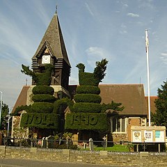
963:== {{int:filedesc}} == {{Information |description={{en|1=St Mary the Virgin, Bedfont. Celebrated and historic topiary, thought to represent peacocks.}} |date=2005-10-03 |source=From |author=[http:/
102:
70:
167:
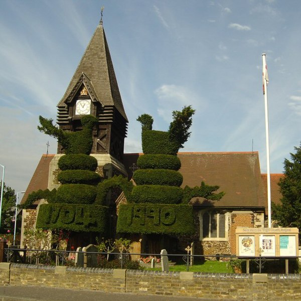
Parish church of St Mary the Virgin, Staines Road, East
Bedfont, Middlesex, seen from the southeast. In front of it is a large work of historic topiary, thought to represent peacocks.
982:
702:
666:
630:
511:
313:
271:
945:
940:
737:
61:
42:
1140:
348:
1013:
This file contains additional information, probably added from the digital camera or scanner used to create or digitize it.
891:
438:
580:
875:
841:
773:
745:
686:
614:
588:
573:
558:
807:
730:
715:
650:
531:
495:
335:
394:
1016:
If the file has been modified from its original state, some details may not fully reflect the modified file.
973:
The following pages on the
English Knowledge (XXG) use this file (pages on other projects are not listed):
1167:
437:– If you remix, transform, or build upon the material, you must distribute your contributions under the
355:
on the
Geograph website for the photographer's contact details. The copyright on this image is owned by
956:
391:
134:
1203:
110:
224:
129:
752:
722:
565:
208:
319:
277:
1239:
1185:
1042:
360:
97:
1082:
1213:
176:
1062:
303:
261:
197:
187:
1052:
340:
1035:
977:
1208:
Flash fired, strobe return light not detected, compulsory flash firing
352:
913:
Click on a date/time to view the file as it appeared at that time.
1025:
305:
263:
288:
246:
85:
834:
766:
157:
St Mary the Virgin, Bedfont - geograph.org.uk - 118638.jpg
298:
51° 27′ 05″ N, 0° 26′ 20″ W
256:
51° 27′ 02″ N, 0° 26′ 28″ W
479:
Add a one-line explanation of what this file represents
1000:
983:
List of public art in the London
Borough of Hounslow
151:
123:
109:
Commons is a freely licensed media file repository.
667:
Creative
Commons Attribution-ShareAlike 2.0 Generic
75:(640 × 640 pixels, file size: 152 KB, MIME type:
448:https://creativecommons.org/licenses/by-sa/2.0
90:
454:Creative Commons Attribution-Share Alike 2.0
372:
8:
414:– to copy, distribute and transmit the work
1018:
915:
475:
993:The following other wikis use this file:
723:https://www.geograph.org.uk/photo/118638
566:https://www.geograph.org.uk/profile/4922
1247:
1237:
1229:
1221:
1211:
1201:
1193:
1183:
1175:
1165:
1157:
1149:
1138:
1130:
1122:
1114:
1106:
1098:
1090:
1079:
1071:
1060:
1050:
1040:
1030:
975:
889:
873:
855:
839:
821:
805:
787:
771:
700:
684:
664:
648:
628:
612:
545:
529:
509:
493:
490:
471:
464:
291:
249:
312:View this and other nearby images on:
270:View this and other nearby images on:
1020:
7:
359:and is licensed for reuse under the
904:
395:Attribution-Share Alike 2.0 Generic
383:
378:
363:Attribution-ShareAlike 2.0 license.
1011:
484:
478:
369:
346:
161:
127:
122:
68:
483:
1073:Date and time of data generation
774:coordinates of the point of view
469:
425:Under the following conditions:
390:This file is licensed under the
382:
377:
371:
339:
318:
304:
276:
262:
89:
31:
21:
466:
162:
14:
703:file available on the internet
465:
347:This image was taken from the
26:
1:
842:coordinates of depicted place
36:
738:Geograph Britain and Ireland
574:object of statement has role
491:Items portrayed in this file
1151:Date and time of digitizing
239:St Mary the Virgin, Bedfont
220:St Mary the Virgin, Bedfont
1269:
997:Usage on www.wikidata.org
892:London Borough of Hounslow
439:same or compatible license
1116:File change date and time
905:
16:
857:51°27'5.0"N, 0°26'20.4"W
789:51°27'2.2"N, 0°26'27.6"W
746:geograph.org.uk image ID
468:
405:
96:This is a file from the
1223:Custom image processing
962:
237:Jon Bryant /
218:Jon Bryant /
209:required by the license
193:
182:
175:
172:
154:
100:. Information from its
1159:Image compression mode
1119:11:57, 8 February 2006
941:12:28, 31 January 2010
353:this photograph's page
324:51.451400; -0.439000
282:51.450600; -0.441000
103:description page there
46:Size of this preview:
1177:Maximum land aperture
1154:11:57, 3 October 2005
1100:Horizontal resolution
1076:11:57, 3 October 2005
876:location of creation
1124:Y and C positioning
1108:Vertical resolution
1022:Camera manufacturer
420:– to adapt the work
128:This is a photo of
52:Other resolutions:
1249:Scene capture type
1244:Auto white balance
589:author name string
1256:
1255:
1047:1/500 sec (0.002)
989:Global file usage
966:
651:copyright license
512:Church of St Mary
477:
368:
367:
351:collection. See
329:
328:
287:
286:
244:
243:
212:
144:
143:
118:
117:
98:Wikimedia Commons
32:Global file usage
1260:
1132:Exposure Program
1019:
953:
755:
750:
740:
735:
725:
720:
716:described at URL
615:copyright status
596:
593:
583:
578:
568:
563:
461:
458:
455:
452:
449:
441:as the original.
403:
392:Creative Commons
386:
385:
381:
380:
375:
374:
361:Creative Commons
349:Geograph project
343:
336:
325:
322:
308:
307:
301:
300:
289:
283:
280:
266:
265:
259:
258:
247:
206:
178:
166:
158:
152:
137:
124:
114:
93:
92:
86:
80:
78:
65:
62:640 × 640 pixels
58:480 × 480 pixels
54:240 × 240 pixels
48:600 × 600 pixels
1268:
1267:
1263:
1262:
1261:
1259:
1258:
1257:
1180:3 APEX (f/2.83)
1007:
987:
974:
967:
959:
951:
907:
906:
903:
902:
901:
900:
899:
898:
897:
896:
894:
882:
881:
880:
878:
867:
866:
865:
864:
863:
862:
861:
860:
858:
848:
847:
846:
844:
833:
832:
831:
830:
829:
828:
827:
826:
824:
814:
813:
812:
810:
799:
798:
797:
796:
795:
794:
793:
792:
790:
780:
779:
778:
776:
765:
764:
763:
762:
761:
760:
759:
758:
757:
756:
751:
748:
742:
741:
736:
733:
727:
726:
721:
718:
709:
708:
707:
705:
693:
692:
691:
689:
678:
677:
676:
675:
674:
673:
672:
671:
669:
657:
656:
655:
653:
642:
641:
640:
639:
638:
637:
636:
635:
633:
621:
620:
619:
617:
606:
605:
604:
603:
602:
601:
600:
599:
598:
597:
594:
591:
585:
584:
579:
576:
570:
569:
564:
561:
552:
551:
550:
548:
538:
537:
536:
534:
523:
522:
521:
520:
519:
518:
517:
516:
514:
502:
501:
500:
498:
482:
481:
480:
463:
462:
459:
456:
453:
450:
447:
446:
404:
401:
398:
387:
364:
334:
323:
296:
295:
292:Object location
281:
254:
253:
250:Camera location
245:
234:
227:
215:
188:geograph.org.uk
168:
156:
149:
139:
133:
130:listed building
120:
119:
108:
107:
106:is shown below.
82:
76:
74:
67:
66:
51:
12:
11:
5:
1266:
1264:
1254:
1253:
1250:
1246:
1245:
1242:
1236:
1235:
1232:
1228:
1227:
1226:Normal process
1224:
1220:
1219:
1216:
1210:
1209:
1206:
1200:
1199:
1196:
1192:
1191:
1188:
1182:
1181:
1178:
1174:
1173:
1170:
1164:
1163:
1160:
1156:
1155:
1152:
1148:
1147:
1144:
1137:
1136:
1135:Normal program
1133:
1129:
1128:
1125:
1121:
1120:
1117:
1113:
1112:
1109:
1105:
1104:
1101:
1097:
1096:
1093:
1089:
1088:
1085:
1078:
1077:
1074:
1070:
1069:
1066:
1059:
1058:
1055:
1049:
1048:
1045:
1039:
1038:
1033:
1029:
1028:
1023:
1010:
1006:
1005:
1004:
1003:
991:
990:
986:
985:
980:
972:
971:
970:
965:
964:
961:
957:
954:
948:
943:
938:
934:
933:
930:
927:
924:
921:
918:
911:
910:
895:
890:
888:
887:
886:
885:
884:
883:
879:
874:
872:
871:
870:
869:
868:
859:
856:
854:
853:
852:
851:
850:
849:
845:
840:
838:
837:
836:
835:
825:
823:3 October 2005
822:
820:
819:
818:
817:
816:
815:
811:
806:
804:
803:
802:
801:
800:
791:
788:
786:
785:
784:
783:
782:
781:
777:
772:
770:
769:
768:
767:
744:
743:
729:
728:
714:
713:
712:
711:
710:
706:
701:
699:
698:
697:
696:
695:
694:
690:
687:source of file
685:
683:
682:
681:
680:
679:
670:
665:
663:
662:
661:
660:
659:
658:
654:
649:
647:
646:
645:
644:
643:
634:
629:
627:
626:
625:
624:
623:
622:
618:
613:
611:
610:
609:
608:
607:
587:
586:
572:
571:
557:
556:
555:
554:
553:
549:
546:
544:
543:
542:
541:
540:
539:
535:
530:
528:
527:
526:
525:
524:
515:
510:
508:
507:
506:
505:
504:
503:
499:
494:
492:
489:
488:
487:
486:
485:
474:
473:
470:
467:
445:
444:
443:
442:
432:
423:
422:
421:
415:
408:You are free:
399:
389:
388:
370:
366:
365:
344:
333:
330:
327:
326:
316:
310:
293:
285:
284:
274:
268:
251:
242:
241:
235:
232:
229:
228:
223:
216:
213:
201:
200:
195:
191:
190:
184:
180:
179:
177:3 October 2005
174:
170:
169:
159:
150:
148:
145:
142:
141:
121:
116:
115:
94:
84:
83:
45:
41:
40:
39:
34:
29:
24:
19:
13:
10:
9:
6:
4:
3:
2:
1265:
1251:
1248:
1243:
1241:
1240:White balance
1238:
1234:Auto exposure
1233:
1231:Exposure mode
1230:
1225:
1222:
1217:
1215:
1212:
1207:
1205:
1202:
1197:
1194:
1189:
1187:
1186:Metering mode
1184:
1179:
1176:
1171:
1169:
1168:Exposure bias
1166:
1161:
1158:
1153:
1150:
1145:
1142:
1139:
1134:
1131:
1126:
1123:
1118:
1115:
1110:
1107:
1102:
1099:
1094:
1091:
1086:
1084:
1080:
1075:
1072:
1067:
1064:
1061:
1056:
1054:
1051:
1046:
1044:
1043:Exposure time
1041:
1037:
1034:
1031:
1027:
1024:
1021:
1017:
1014:
1008:
1002:
999:
998:
996:
995:
994:
988:
984:
981:
979:
976:
968:
960:
955:
949:
947:
944:
942:
939:
936:
935:
931:
928:
925:
922:
919:
917:
916:
914:
908:
893:
877:
843:
809:
775:
754:
747:
739:
732:
724:
717:
704:
688:
668:
652:
632:
616:
590:
582:
575:
567:
560:
533:
513:
497:
451:CC BY-SA 2.0
440:
436:
433:
430:
427:
426:
424:
419:
416:
413:
410:
409:
407:
406:
400:Attribution:
396:
393:
376:
362:
358:
354:
350:
345:
342:
338:
337:
331:
321:
317:
315:
314:OpenStreetMap
311:
309:
299:
294:
290:
279:
275:
273:
272:OpenStreetMap
269:
267:
257:
252:
248:
240:
236:
231:
230:
226:
222: /
221:
217:
210:
205:
203:
202:
199:
196:
192:
189:
185:
181:
171:
165:
160:
153:
146:
140:
136:
131:
126:
125:
112:
105:
104:
99:
95:
88:
87:
81:
72:
71:Original file
63:
59:
55:
49:
44:
38:
35:
33:
30:
28:
25:
23:
20:
18:
15:
1195:Light source
1083:focal length
1032:Camera model
1015:
1012:
992:
912:
909:File history
581:photographer
434:
428:
417:
411:
356:
238:
225:CC BY-SA 2.0
219:
163:
111:You can help
101:
69:
22:File history
1214:Color space
1092:Orientation
958:GeographBot
631:copyrighted
435:share alike
429:attribution
204:Attribution
155:Description
969:File usage
950:640 × 640
926:Dimensions
595:Jon Bryant
547:some value
402:Jon Bryant
357:Jon Bryant
198:Jon Bryant
77:image/jpeg
27:File usage
1063:ISO speed
1001:Q26642998
923:Thumbnail
920:Date/Time
808:inception
332:Licensing
233:InfoField
214:InfoField
164:English:
1252:Standard
1127:Co-sited
1053:F-number
1009:Metadata
952:(152 KB)
731:operator
472:Captions
418:to remix
412:to share
397:license.
37:Metadata
1198:Unknown
1190:Pattern
1143:version
1036:DSC-P12
978:Bedfont
937:current
932:Comment
532:creator
496:depicts
476:English
147:Summary
135:1360959
132:number
73:
1111:72 dpi
1103:72 dpi
1095:Normal
1087:7.9 mm
1065:rating
753:118638
302:
260:
194:Author
183:Source
1204:Flash
1081:Lens
1057:f/5.6
186:From
1218:sRGB
1141:Exif
1026:SONY
929:User
460:true
457:true
173:Date
17:File
1146:2.2
1068:100
559:URL
749::
734::
719::
592::
577::
562::
60:|
56:|
50:.
1172:0
1162:4
211:)
207:(
138:.
113:.
79:)
64:.
Text is available under the Creative Commons Attribution-ShareAlike License. Additional terms may apply.

_&language=en)
_&language=en)
