326:
43:
256:
270:
294:
332:
337:
87:
846:
247:
384:– You must give appropriate credit, provide a link to the license, and indicate if changes were made. You may do so in any reasonable manner, but not in any way that suggests the licensor endorses you or your use.
53:
47:
66:
98:
881:
184:
845:
840:
57:
42:
636:
600:
564:
263:
686:
1095:
301:
977:
This file contains additional information, probably added from the digital camera or scanner used to create or digitize it.
757:
391:
856:
499:
777:
741:
664:
620:
548:
520:
507:
492:
707:
679:
649:
584:
465:
448:
288:
347:
980:
If the file has been modified from its original state, some details may not fully reflect the modified file.
1140:
390:– If you remix, transform, or build upon the material, you must distribute your contributions under the
308:
on the
Geograph website for the photographer's contact details. The copyright on this image is owned by
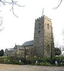
863:== Summary == {{Information |Description=St Remigius, Hethersett, Norfolk |Source=From ; transferd by
999:
344:
1168:
1072:
106:
216:
671:
656:
527:
200:
989:
269:
1236:
1158:
1122:
1006:
313:
93:
1246:
1035:
1178:
867:
using [http://toolserver.org/~magnus/geograph_org2commons.php geograph_org2commo
864:
143:
886:
253:
904:
924:
173:
158:
154:
1016:
293:
305:
813:
Click on a date/time to view the file as it appeared at that time.
255:
770:
162:
131:
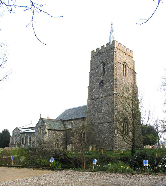
St
Remigius, Hethersett, Norfolk - geograph.org.uk - 315351.jpg
238:
81:
248:
52° 35′ 56″ N, 1° 11′ 23″ E
954:
944:
934:
914:
432:
Add a one-line explanation of what this file represents
964:
191:
Creative
Commons Attribution Share-alike license 2.0
125:
105:
Commons is a freely licensed media file repository.
601:
Creative
Commons Attribution-ShareAlike 2.0 Generic
71:(573 × 640 pixels, file size: 121 KB, MIME type:
401:https://creativecommons.org/licenses/by-sa/2.0
86:
407:Creative Commons Attribution-Share Alike 2.0
325:
8:
882:Grade II* listed buildings in South Norfolk
367:– to copy, distribute and transmit the work
982:
815:
428:
897:The following other wikis use this file:
657:https://www.geograph.org.uk/photo/315351
528:https://www.geograph.org.uk/profile/9419
1255:
1244:
1234:
1226:
1218:
1210:
1202:
1194:
1186:
1176:
1166:
1156:
1148:
1138:
1130:
1120:
1112:
1104:
1093:
1085:
1077:
1067:
1059:
1051:
1043:
1032:
1024:
1014:
1004:
994:
879:
791:
775:
755:
739:
721:
705:
634:
618:
598:
582:
562:
546:
479:
463:
446:
443:
424:
417:
241:
262:View this and other nearby images on:
984:
877:The following 2 pages use this file:
7:
312:and is licensed for reuse under the
804:
348:Attribution-Share Alike 2.0 Generic
336:
331:
316:Attribution-ShareAlike 2.0 license.
975:
437:
431:
322:
299:
118:
64:
436:
1026:Date and time of data generation
422:
378:Under the following conditions:
343:This file is licensed under the
335:
330:
324:
292:
268:
254:
231:St Remigius, Hethersett, Norfolk
212:St Remigius, Hethersett, Norfolk
135:St Remigius, Hethersett, Norfolk
85:
31:
21:
858:File Upload Bot (Magnus Manske)
419:
14:
637:file available on the internet
418:
300:This image was taken from the
26:
1:
1173:Flash did not fire, auto mode
778:coordinates of depicted place
36:
687:Geograph Britain and Ireland
493:object of statement has role
444:Items portrayed in this file
1204:Focal plane resolution unit
1106:Date and time of digitizing
901:Usage on azb.wikipedia.org
793:52°35'55.86"N, 1°11'22.56"E
1277:
1215:One-chip color area sensor
961:Usage on www.wikidata.org
951:Usage on tr.wikipedia.org
941:Usage on pl.wikipedia.org
931:Usage on nl.wikipedia.org
921:Usage on fa.wikipedia.org
911:Usage on de.wikipedia.org
392:same or compatible license
1079:File change date and time
805:
16:
1196:Focal plane Y resolution
1188:Focal plane X resolution
665:geograph.org.uk image ID
421:
358:
229:John Salmon /
210:John Salmon /
92:This is a file from the
1220:Custom image processing
862:
201:required by the license
179:
169:
149:
142:
139:
128:
96:. Information from its
1114:Image compression mode
1082:13:06, 19 January 2007
841:16:14, 26 October 2009
306:this photograph's page
274:52.598850; 1.189600
99:description page there
46:Size of this preview:
1150:Maximum land aperture
1053:Horizontal resolution
1153:2.53125 APEX (f/2.4)
1000:Canon PowerShot Pro1
758:Canon PowerShot Pro1
163:geograph_org2commons
1109:16:32, 1 April 2005
1087:Y and C positioning
1073:Adobe Photoshop 7.0
1061:Vertical resolution
1029:16:32, 1 April 2005
986:Camera manufacturer
373:– to adapt the work
52:Other resolutions:
1257:Scene capture type
1241:Auto white balance
508:author name string
1264:
1263:
1011:1/250 sec (0.004)
893:Global file usage
870:
585:copyright license
430:
321:
320:
304:collection. See
279:
278:
236:
235:
204:
188:
185:Reusing this file
157:; transferred by
114:
113:
94:Wikimedia Commons
32:Global file usage
1268:
1199:9,415.3846153846
1191:9,406.3400576369
983:
853:
689:
684:
674:
669:
659:
654:
650:described at URL
549:copyright status
530:
525:
515:
512:
502:
497:
414:
411:
408:
405:
402:
394:as the original.
356:
345:Creative Commons
339:
338:
334:
333:
328:
327:
314:Creative Commons
302:Geograph project
296:
289:
275:
272:
258:
257:
251:
250:
239:
198:
182:
145:
132:
126:
110:
89:
88:
82:
76:
74:
61:
58:573 × 640 pixels
54:215 × 240 pixels
48:537 × 600 pixels
1276:
1275:
1271:
1270:
1269:
1267:
1266:
1265:
971:
891:
871:
859:
851:
807:
806:
803:
802:
801:
800:
799:
798:
797:
796:
794:
784:
783:
782:
780:
769:
768:
767:
766:
765:
764:
763:
762:
760:
748:
747:
746:
744:
733:
732:
731:
730:
729:
728:
727:
726:
724:
714:
713:
712:
710:
699:
698:
697:
696:
695:
694:
693:
692:
691:
690:
685:
682:
676:
675:
670:
667:
661:
660:
655:
652:
643:
642:
641:
639:
627:
626:
625:
623:
612:
611:
610:
609:
608:
607:
606:
605:
603:
591:
590:
589:
587:
576:
575:
574:
573:
572:
571:
570:
569:
567:
555:
554:
553:
551:
540:
539:
538:
537:
536:
535:
534:
533:
532:
531:
526:
523:
517:
516:
513:
510:
504:
503:
498:
495:
486:
485:
484:
482:
472:
471:
470:
468:
457:
456:
455:
454:
453:
451:
435:
434:
433:
416:
415:
412:
409:
406:
403:
400:
399:
357:
354:
351:
340:
317:
287:
273:
246:
245:
242:Object location
237:
226:
219:
207:
155:geograph.org.uk
130:
123:
116:
115:
104:
103:
102:is shown below.
78:
72:
70:
63:
62:
51:
12:
11:
5:
1274:
1272:
1262:
1261:
1258:
1254:
1253:
1250:
1243:
1242:
1239:
1233:
1232:
1229:
1225:
1224:
1223:Normal process
1221:
1217:
1216:
1213:
1212:Sensing method
1209:
1208:
1205:
1201:
1200:
1197:
1193:
1192:
1189:
1185:
1184:
1181:
1175:
1174:
1171:
1165:
1164:
1161:
1155:
1154:
1151:
1147:
1146:
1143:
1137:
1136:
1133:
1129:
1128:
1125:
1119:
1118:
1115:
1111:
1110:
1107:
1103:
1102:
1099:
1092:
1091:
1088:
1084:
1083:
1080:
1076:
1075:
1070:
1066:
1065:
1062:
1058:
1057:
1054:
1050:
1049:
1046:
1042:
1041:
1038:
1031:
1030:
1027:
1023:
1022:
1019:
1013:
1012:
1009:
1003:
1002:
997:
993:
992:
987:
974:
970:
969:
968:
967:
959:
958:
957:
949:
948:
947:
939:
938:
937:
929:
928:
927:
919:
918:
917:
909:
908:
907:
895:
894:
890:
889:
884:
875:
874:
869:
868:
861:
857:
854:
848:
843:
838:
834:
833:
830:
827:
824:
821:
818:
811:
810:
795:
792:
790:
789:
788:
787:
786:
785:
781:
776:
774:
773:
772:
771:
761:
756:
754:
753:
752:
751:
750:
749:
745:
740:
738:
737:
736:
735:
734:
725:
722:
720:
719:
718:
717:
716:
715:
711:
706:
704:
703:
702:
701:
700:
678:
677:
663:
662:
648:
647:
646:
645:
644:
640:
635:
633:
632:
631:
630:
629:
628:
624:
621:source of file
619:
617:
616:
615:
614:
613:
604:
599:
597:
596:
595:
594:
593:
592:
588:
583:
581:
580:
579:
578:
577:
568:
563:
561:
560:
559:
558:
557:
556:
552:
547:
545:
544:
543:
542:
541:
519:
518:
506:
505:
491:
490:
489:
488:
487:
483:
480:
478:
477:
476:
475:
474:
473:
469:
464:
462:
461:
460:
459:
458:
452:
447:
445:
442:
441:
440:
439:
438:
427:
426:
423:
420:
398:
397:
396:
395:
385:
376:
375:
374:
368:
361:You are free:
352:
342:
341:
323:
319:
318:
297:
286:
283:
277:
276:
266:
260:
243:
234:
233:
227:
224:
221:
220:
215:
208:
205:
193:
192:
189:
177:
176:
171:
167:
166:
151:
147:
146:
141:
137:
136:
133:
124:
122:
119:
117:
112:
111:
90:
80:
79:
45:
41:
40:
39:
34:
29:
24:
19:
13:
10:
9:
6:
4:
3:
2:
1273:
1259:
1256:
1251:
1248:
1245:
1240:
1238:
1237:White balance
1235:
1231:Auto exposure
1230:
1228:Exposure mode
1227:
1222:
1219:
1214:
1211:
1206:
1203:
1198:
1195:
1190:
1187:
1182:
1180:
1177:
1172:
1170:
1167:
1162:
1160:
1159:Metering mode
1157:
1152:
1149:
1144:
1142:
1141:Exposure bias
1139:
1134:
1132:APEX aperture
1131:
1126:
1124:
1123:Shutter speed
1121:
1116:
1113:
1108:
1105:
1100:
1097:
1094:
1089:
1086:
1081:
1078:
1074:
1071:
1069:Software used
1068:
1063:
1060:
1055:
1052:
1047:
1044:
1039:
1037:
1033:
1028:
1025:
1020:
1018:
1015:
1010:
1008:
1007:Exposure time
1005:
1001:
998:
995:
991:
988:
985:
981:
978:
972:
966:
963:
962:
960:
956:
953:
952:
950:
946:
943:
942:
940:
936:
933:
932:
930:
926:
923:
922:
920:
916:
913:
912:
910:
906:
903:
902:
900:
899:
898:
892:
888:
885:
883:
880:
878:
872:
866:
860:
855:
849:
847:
844:
842:
839:
836:
835:
831:
828:
825:
822:
819:
817:
816:
814:
808:
779:
759:
743:
742:captured with
709:
688:
681:
673:
666:
658:
651:
638:
622:
602:
586:
566:
550:
529:
522:
509:
501:
494:
467:
450:
404:CC BY-SA 2.0
393:
389:
386:
383:
380:
379:
377:
372:
369:
366:
363:
362:
360:
359:
353:Attribution:
349:
346:
329:
315:
311:
307:
303:
298:
295:
291:
290:
284:
282:
281:
271:
267:
265:
264:OpenStreetMap
261:
259:
249:
244:
240:
232:
228:
223:
222:
218:
214: /
213:
209:
202:
197:
195:
194:
190:
186:
181:
178:
175:
172:
168:
164:
160:
156:
152:
148:
138:
134:
127:
120:
108:
101:
100:
95:
91:
84:
83:
77:
68:
67:Original file
59:
55:
49:
44:
38:
35:
33:
30:
28:
25:
23:
20:
18:
15:
1247:Digital zoom
1036:focal length
996:Camera model
979:
976:
896:
876:
812:
809:File history
723:1 April 2005
500:photographer
387:
381:
370:
364:
309:
280:
230:
217:CC BY-SA 2.0
211:
144:1 April 2005
107:You can help
97:
65:
22:File history
1179:Color space
1045:Orientation
865:User:oxyman
565:copyrighted
514:John Salmon
388:share alike
382:attribution
355:John Salmon
310:John Salmon
196:Attribution
174:John Salmon
159:User:oxyman
129:Description
955:Hethersett
945:Hethersett
935:Hethersett
915:Hethersett
887:Hethersett
873:File usage
850:573 × 640
826:Dimensions
481:some value
180:Permission
73:image/jpeg
27:File usage
1040:7.1875 mm
965:Q17533064
823:Thumbnail
820:Date/Time
708:inception
285:Licensing
225:InfoField
206:InfoField
1260:Standard
1090:Centered
1017:F-number
973:Metadata
852:(121 KB)
680:operator
425:Captions
371:to remix
365:to share
350:license.
37:Metadata
1163:Pattern
1127:7.96875
1098:version
1064:180 dpi
1056:180 dpi
837:current
832:Comment
466:creator
449:depicts
429:English
121:Summary
69:
1207:inches
1048:Normal
672:315351
252:
170:Author
161:using
150:Source
1249:ratio
1169:Flash
1034:Lens
990:Canon
925:هسرست
905:هسرست
153:From
1183:sRGB
1101:2.21
1096:Exif
829:User
413:true
410:true
140:Date
17:File
1021:f/4
521:URL
683::
668::
653::
524::
511::
496::
56:|
50:.
1252:1
1145:0
1135:4
1117:3
203:)
199:(
187:)
183:(
165:.
109:.
75:)
60:.
Text is available under the Creative Commons Attribution-ShareAlike License. Additional terms may apply.
_region:GB-GBN_&language=en)
