497:
674:
43:
590:
379:
367:
391:
631:
582:
604:
680:
535:
685:
469:
99:
458:
1393:
1325:
1295:
1265:
1503:
743:– You must give appropriate credit, provide a link to the license, and indicate if changes were made. You may do so in any reasonable manner, but not in any way that suggests the licensor endorses you or your use.
573:
550:
1573:
507:
1583:
1346:, New Zealand. * Altitude levels: 50 m, 125, 250, 500, etc. (same for bathymetry). * Projection: New Zealand Geodetic Datum 2000 ; GRS
73:
69:
65:
61:
57:
53:
47:
511:
317:
278:
1086:
1050:
1033:
1016:
999:
982:
929:
597:
110:
82:
1626:
This file contains additional information, probably added from the digital camera or scanner used to create or digitize it.
965:
750:
1593:
1196:
1167:
1140:
1070:
913:
885:
870:
857:
327:
288:
1423:
1360:
1106:
949:
830:
813:
1324:
1319:
1294:
1289:
546:
892:
156:
496:
1343:
712:
708:
704:
700:
696:
542:
1629:
If the file has been modified from its original state, some details may not fully reflect the modified file.
1356:
The following pages on the
English Knowledge (XXG) use this file (pages on other projects are not listed):
485:
749:– If you remix, transform, or build upon the material, you must distribute your contributions under the
636:
Copyleft: This work of art is free; you can redistribute it and/or modify it according to terms of the
692:
638:
877:
118:
378:
311:
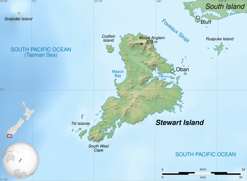
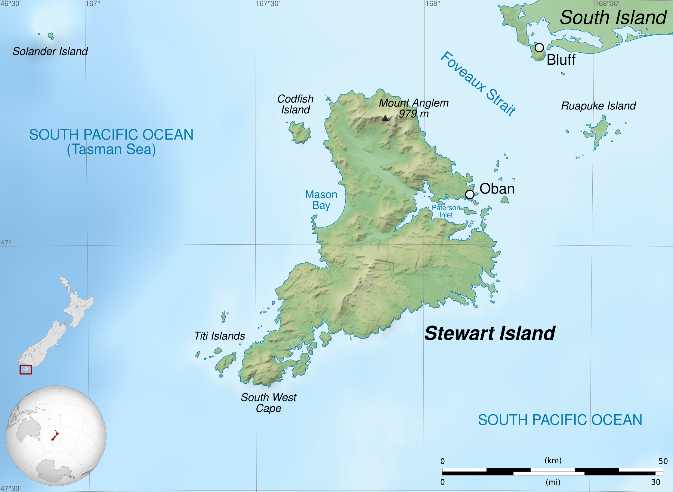
Topographie : NASA Shuttle Radar
Topography Mission (SRTM3 v.2) (domaine public) ;
1264:
1259:
408:
366:
308:
Tracé des côtes : NASA Shuttle Radar
Topography Mission (SWBD) (domaine public) ;
42:
390:
349:
1342:== {{int:filedesc}} == {{Information |Description={{Multilingual description |en=Map of
1365:
1335:
1305:
1275:
603:
478:
331:
292:
424:
622:
I, the copyright holder of this work, hereby publish it under the following licenses:
534:
105:
272:
Topography: NASA Shuttle Radar
Topography Mission (SRTM3 v.2) (public domain) ;
200:
208:
Projection : New
Zealand Geodetic Datum 2000 ; système géodésique GRS80.
1613:
345:
269:
Shorelines: NASA Shuttle Radar
Topography Mission (SWBD) (public domain) ;
242:
647:
625:
205:
Niveaux d'altitudes : 50 m, 125, 250, 500, etc. Idem pour la bathymétrie.
321:
282:
482:
587:
442:
419:
643:
1603:
1553:
506:
into your language, using any capable SVG editor, text editor or the
428:
1413:
491:
1232:
Click on a date/time to view the file as it appeared at that time.
1478:
1383:
162:
Altitude levels: 50 m, 125, 250, 500, etc. (same for bathymetry).
589:
468:
1563:
1543:
165:
Projection: New
Zealand Geodetic Datum 2000 ; GRS80 datum.
564:
93:
87:(SVG file, nominally 2,237 × 1,635 pixels, file size: 1.7 MB)
457:
1523:
1453:
1433:
574:
47° 00′ 00″ S, 167° 45′ 00″ E
1533:
1513:
1493:
1473:
1463:
1483:
1443:
1017:
Creative
Commons Attribution-ShareAlike 4.0 International
1638:
Map of
Stewart island, or Rakiura, south of New Zealand
797:
Add a one-line explanation of what this file represents
314:
Bathymetrie : NGDC ETOPO1 (domaine public) ;
1403:
1034:
Creative
Commons Attribution-ShareAlike 3.0 Unported
137:
117:
Commons is a freely licensed media file repository.
1051:
Creative Commons Attribution-ShareAlike 2.0 Generic
1000:
Creative Commons Attribution-ShareAlike 1.0 Generic
983:
Creative Commons Attribution-ShareAlike 2.5 Generic
553:to clean up, improve, create or translate as well.
642:. You will find a specimen of this license on the
878:https://commons.wikimedia.org/user:S%C3%A9mhur
760:https://creativecommons.org/licenses/by-sa/4.0
275:Bathymetry: NGDC ETOPO1 (public domain) ;
98:
766:Creative Commons Attribution-Share Alike 4.0
673:
8:
726:– to copy, distribute and transmit the work
46:Size of this PNG preview of this SVG file:
1631:
1234:
793:
778:You may select the license of your choice.
529:
1376:The following other wikis use this file:
630:
541:This map was improved or created by the
217:Limites géographiques de la carte :
1649:
1641:
1633:
1358:
1210:
1194:
1154:
1138:
1120:
1104:
1084:
1068:
1048:
1031:
1014:
997:
980:
963:
947:
927:
911:
844:
828:
811:
808:
789:
782:
567:
362:
596:View this and other nearby images on:
211:Méridien de référence : 167°45' E
7:
504:embedded text that can be translated
1223:
684:
679:
214:Parallèle de référence : 47° S
1624:
802:
796:
777:
670:
652:http://artlibre.org/licence/lal/en
621:
540:
473:
462:
324:sous licence domaine public ;
299:
295:under licence GFDL or CC-BY-SA 3.0
285:under licence Public Domain ;
259:
192:
148:
130:
80:
801:
334:sous licence GFDL ou CC-BY-SA 3.0
318:NZL orthographic NaturalEarth.svg
279:NZL orthographic NaturalEarth.svg
203:, au sud de la Nouvelle-Zélande.
1141:coordinates of the point of view
787:
737:Under the following conditions:
691:This file is licensed under the
683:
678:
672:
629:
602:
588:
580:
533:
495:
467:
456:
389:
377:
365:
97:
31:
21:
784:
14:
1540:Usage on simple.wikipedia.org
783:
175:Geographic limits of the map:
26:
1:
1087:original creation by uploader
36:
1394:বিশ্বের প্রণালীসমূহের তালিকা
809:Items portrayed in this file
510:. For more information see:
494:
328:New Zealand location map.svg
289:New Zealand location map.svg
168:Standard meridian: 167°45' E
1380:Usage on ast.wikipedia.org
1361:Codfish Island / Whenua Hou
1344:en:Stewart Island / Rakiura
512:About translating SVG files
1671:
1610:Usage on zh.wikipedia.org
1600:Usage on vi.wikipedia.org
1590:Usage on uk.wikipedia.org
1580:Usage on th.wikipedia.org
1570:Usage on ta.wikipedia.org
1560:Usage on sv.wikipedia.org
1550:Usage on sl.wikipedia.org
1530:Usage on pl.wikipedia.org
1520:Usage on no.wikipedia.org
1510:Usage on nl.wikipedia.org
1500:Usage on ml.wikipedia.org
1490:Usage on lv.wikipedia.org
1470:Usage on lt.wikipedia.org
1460:Usage on kw.wikipedia.org
1450:Usage on hu.wikipedia.org
1440:Usage on gl.wikipedia.org
1430:Usage on fi.wikipedia.org
1420:Usage on fa.wikipedia.org
1410:Usage on de.wikipedia.org
1400:Usage on br.wikipedia.org
1390:Usage on bn.wikipedia.org
751:same or compatible license
579:
501:
171:True scale parallel: 47° S
1224:
463:W3C-validity not checked.
300:
260:
253:
193:
149:
143:Stewart Island map-en.svg
16:
1554:Stewartov otok / Rakiura
786:
717:
695:Attribution-Share Alike
157:Stewart Island / Rakiura
104:This is a file from the
1414:Titi/Muttonbird Islands
1341:
1311:
1281:
608:-47.000000; 167.750000
532:
502:This SVG file contains
409:required by the license
358:
341:
248:
241:
238:
140:
108:. Information from its
1504:സ്റ്റ്യൂവാർട്ട് ഐലന്റ്
1260:21:39, 3 February 2020
644:Copyleft Attitude site
111:description page there
441:© Sémhur /
418:© Sémhur /
221:Ouest : 166.75 E
1320:21:22, 27 April 2011
74:2,237 × 1,635 pixels
70:2,560 × 1,871 pixels
1384:Estrechu de Foveaux
732:– to adapt the work
549:(fr). You can
224:Est : 168.75 E
52:Other resolutions:
1564:William W. Stewart
1290:07:58, 2 June 2014
886:Wikimedia username
858:author name string
508:SVG Translate tool
227:Nord : 46.5 S
66:1,280 × 936 pixels
62:1,024 × 748 pixels
1658:
1657:
1372:Global file usage
1349:
950:copyright license
795:
697:4.0 International
669:
668:
613:
612:
562:
561:
558:
557:
518:
517:
481:was created with
443:Wikimedia Commons
420:Wikimedia Commons
412:
230:Sud : 47.5 S
126:
125:
106:Wikimedia Commons
32:Global file usage
1662:
1632:
1332:
1302:
1272:
1178:
1177:
1172:
966:Free Art License
914:copyright status
895:
890:
880:
875:
865:
862:
773:
770:
767:
764:
761:
753:as the original.
693:Creative Commons
687:
686:
682:
681:
676:
675:
665:
662:
659:
658:Free Art License
656:
653:
639:Free Art License
633:
632:
626:
609:
606:
592:
591:
585:
584:
583:
577:
576:
565:
537:
530:
499:
492:
471:
460:
429:Free Art License
406:
393:
381:
369:
352:
305:
265:
255:
244:
198:
154:
144:
138:
122:
101:
100:
94:
88:
77:
58:640 × 468 pixels
54:320 × 234 pixels
48:800 × 585 pixels
1670:
1669:
1665:
1664:
1663:
1661:
1660:
1659:
1620:
1594:Стюарт (острів)
1479:Kodfišas (sala)
1370:
1357:
1350:
1338:
1330:
1308:
1300:
1278:
1270:
1226:
1225:
1222:
1221:
1220:
1219:
1218:
1217:
1216:
1215:
1213:
1203:
1202:
1201:
1199:
1188:
1187:
1186:
1185:
1184:
1183:
1182:
1181:
1180:
1179:
1175:
1173:
1170:
1161:
1160:
1159:
1157:
1147:
1146:
1145:
1143:
1132:
1131:
1130:
1129:
1128:
1127:
1126:
1125:
1123:
1113:
1112:
1111:
1109:
1098:
1097:
1096:
1095:
1094:
1093:
1092:
1091:
1089:
1077:
1076:
1075:
1073:
1062:
1061:
1060:
1059:
1058:
1057:
1056:
1055:
1053:
1042:
1041:
1040:
1039:
1038:
1036:
1025:
1024:
1023:
1022:
1021:
1019:
1008:
1007:
1006:
1005:
1004:
1002:
991:
990:
989:
988:
987:
985:
974:
973:
972:
971:
970:
968:
956:
955:
954:
952:
941:
940:
939:
938:
937:
936:
935:
934:
932:
920:
919:
918:
916:
905:
904:
903:
902:
901:
900:
899:
898:
897:
896:
891:
888:
882:
881:
876:
873:
867:
866:
863:
860:
851:
850:
849:
847:
837:
836:
835:
833:
822:
821:
820:
819:
818:
816:
800:
799:
798:
781:
780:
779:
775:
774:
771:
768:
765:
762:
759:
758:
716:
688:
663:
660:
657:
654:
651:
624:
623:
618:
607:
581:
572:
571:
568:Camera location
563:
554:
526:
490:
489:
476:W3C-unspecified
465:
464:
452:
438:
431:
415:
397:
394:
385:
382:
373:
370:
350:
337:
336:
303:
298:
263:
234:
233:
196:
191:
159:, New Zealand.
152:
142:
135:
128:
127:
116:
115:
114:is shown below.
90:
86:
79:
78:
51:
12:
11:
5:
1668:
1666:
1656:
1655:
1652:
1648:
1647:
1644:
1640:
1639:
1636:
1623:
1619:
1618:
1617:
1616:
1608:
1607:
1606:
1598:
1597:
1596:
1588:
1587:
1586:
1578:
1577:
1576:
1574:ஸ்டுவர்ட் தீவு
1568:
1567:
1566:
1558:
1557:
1556:
1548:
1547:
1546:
1544:Stewart Island
1538:
1537:
1536:
1528:
1527:
1526:
1524:Stewart Island
1518:
1517:
1516:
1508:
1507:
1506:
1498:
1497:
1496:
1488:
1487:
1486:
1481:
1476:
1468:
1467:
1466:
1458:
1457:
1456:
1454:Stewart-sziget
1448:
1447:
1446:
1438:
1437:
1436:
1434:Stewartinsaari
1428:
1427:
1426:
1418:
1417:
1416:
1408:
1407:
1406:
1398:
1397:
1396:
1388:
1387:
1386:
1374:
1373:
1369:
1368:
1366:Stewart Island
1363:
1355:
1354:
1353:
1348:
1347:
1340:
1336:
1333:
1329:2,237 × 1,635
1327:
1322:
1317:
1314:
1313:
1310:
1306:
1303:
1299:2,237 × 1,635
1297:
1292:
1287:
1284:
1283:
1280:
1276:
1273:
1269:2,237 × 1,635
1267:
1262:
1257:
1253:
1252:
1249:
1246:
1243:
1240:
1237:
1230:
1229:
1214:
1211:
1209:
1208:
1207:
1206:
1205:
1204:
1200:
1195:
1193:
1192:
1191:
1190:
1189:
1166:
1165:
1164:
1163:
1162:
1158:
1155:
1153:
1152:
1151:
1150:
1149:
1148:
1144:
1139:
1137:
1136:
1135:
1134:
1133:
1124:
1121:
1119:
1118:
1117:
1116:
1115:
1114:
1110:
1105:
1103:
1102:
1101:
1100:
1099:
1090:
1085:
1083:
1082:
1081:
1080:
1079:
1078:
1074:
1071:source of file
1069:
1067:
1066:
1065:
1064:
1063:
1054:
1049:
1047:
1046:
1045:
1044:
1043:
1037:
1032:
1030:
1029:
1028:
1027:
1026:
1020:
1015:
1013:
1012:
1011:
1010:
1009:
1003:
998:
996:
995:
994:
993:
992:
986:
981:
979:
978:
977:
976:
975:
969:
964:
962:
961:
960:
959:
958:
957:
953:
948:
946:
945:
944:
943:
942:
933:
928:
926:
925:
924:
923:
922:
921:
917:
912:
910:
909:
908:
907:
906:
884:
883:
869:
868:
856:
855:
854:
853:
852:
848:
845:
843:
842:
841:
840:
839:
838:
834:
829:
827:
826:
825:
824:
823:
817:
812:
810:
807:
806:
805:
804:
803:
792:
791:
788:
785:
776:
757:
756:
755:
754:
744:
735:
734:
733:
727:
720:You are free:
690:
689:
671:
667:
666:
648:on other sites
634:
620:
619:
617:
614:
611:
610:
600:
594:
569:
560:
559:
556:
555:
551:propose images
538:
527:
524:
520:
519:
516:
515:
500:
466:
455:
453:
450:
446:
445:
439:
436:
433:
432:
423:
416:
413:
401:
400:
399:
398:
395:
388:
386:
383:
376:
374:
371:
364:
360:
359:Other versions
356:
355:
343:
339:
338:
335:
325:
315:
312:
309:
301:
297:
296:
286:
276:
273:
270:
261:
258:
250:
246:
245:
240:
236:
235:
232:
231:
228:
225:
222:
215:
212:
209:
206:
194:
190:
189:
186:
183:
182:East: 168.75 E
180:
179:West: 166.75 E
173:
172:
169:
166:
163:
150:
147:
145:
136:
134:
131:
129:
124:
123:
102:
92:
91:
45:
41:
40:
39:
34:
29:
24:
19:
13:
10:
9:
6:
4:
3:
2:
1667:
1653:
1650:
1645:
1642:
1637:
1634:
1630:
1627:
1621:
1615:
1612:
1611:
1609:
1605:
1602:
1601:
1599:
1595:
1592:
1591:
1589:
1585:
1582:
1581:
1579:
1575:
1572:
1571:
1569:
1565:
1562:
1561:
1559:
1555:
1552:
1551:
1549:
1545:
1542:
1541:
1539:
1535:
1534:Wyspa Stewart
1532:
1531:
1529:
1525:
1522:
1521:
1519:
1515:
1514:Stewarteiland
1512:
1511:
1509:
1505:
1502:
1501:
1499:
1495:
1494:Stjuarta sala
1492:
1491:
1489:
1485:
1482:
1480:
1477:
1475:
1474:Stiuarto sala
1472:
1471:
1469:
1465:
1464:Edhen dhineyj
1462:
1461:
1459:
1455:
1452:
1451:
1449:
1445:
1442:
1441:
1439:
1435:
1432:
1431:
1429:
1425:
1424:جزیره استوارت
1422:
1421:
1419:
1415:
1412:
1411:
1409:
1405:
1402:
1401:
1399:
1395:
1392:
1391:
1389:
1385:
1382:
1381:
1379:
1378:
1377:
1371:
1367:
1364:
1362:
1359:
1351:
1345:
1339:
1334:
1328:
1326:
1323:
1321:
1318:
1316:
1315:
1309:
1304:
1298:
1296:
1293:
1291:
1288:
1286:
1285:
1282:Correct scale
1279:
1274:
1268:
1266:
1263:
1261:
1258:
1255:
1254:
1250:
1247:
1244:
1241:
1238:
1236:
1235:
1233:
1227:
1212:image/svg+xml
1198:
1169:
1142:
1122:27 April 2011
1108:
1088:
1072:
1052:
1035:
1018:
1001:
984:
967:
951:
931:
915:
894:
887:
879:
872:
859:
832:
815:
763:CC BY-SA 4.0
752:
748:
745:
742:
739:
738:
736:
731:
728:
725:
722:
721:
719:
718:
714:
710:
706:
702:
698:
694:
677:
649:
645:
641:
640:
635:
628:
627:
615:
605:
601:
599:
598:OpenStreetMap
595:
593:
575:
570:
566:
552:
548:
544:
543:Wikigraphists
539:
536:
531:
528:
522:
521:
513:
509:
505:
498:
493:
487:
484:
480:
477:
470:
459:
454:
448:
447:
444:
440:
435:
434:
430:
426:
422: /
421:
417:
410:
405:
403:
402:
392:
387:
380:
375:
368:
363:
361:
357:
353:
347:
344:
340:
333:
329:
326:
323:
319:
316:
313:
310:
307:
306:
294:
290:
287:
284:
280:
277:
274:
271:
268:
267:
266:
257:
251:
247:
243:27 April 2011
237:
229:
226:
223:
220:
219:
218:
213:
210:
207:
204:
202:
188:South: 47.5 S
187:
185:North: 46.5 S
184:
181:
178:
177:
176:
170:
167:
164:
161:
160:
158:
146:
139:
132:
120:
113:
112:
107:
103:
96:
95:
89:
84:
83:Original file
75:
71:
67:
63:
59:
55:
49:
44:
38:
35:
33:
30:
28:
25:
23:
20:
18:
15:
1628:
1625:
1444:Illa Stewart
1375:
1231:
1228:File history
746:
740:
729:
723:
701:3.0 Unported
637:
578:
503:
479:vector image
475:
425:CC-BY-SA-4.0
332:NordNordWest
293:NordNordWest
252:
216:
174:
119:You can help
109:
81:
22:File history
1635:Short title
1604:Đảo Stewart
1156:47°S, 168°E
930:copyrighted
747:share alike
741:attribution
713:1.0 Generic
709:2.0 Generic
705:2.5 Generic
646:as well as
547:Graphic Lab
523:Graphic Lab
404:Attribution
201:île Stewart
199:Carte de l'
141:Description
1584:เกาะสจวร์ต
1352:File usage
1245:Dimensions
1197:media type
846:some value
486:…important
384:македонски
27:File usage
1312:Valid SVG
1242:Thumbnail
1239:Date/Time
1107:inception
616:Licensing
525:InfoField
451:InfoField
437:InfoField
414:InfoField
1622:Metadata
1331:(1.7 MB)
1301:(1.7 MB)
1271:(1.7 MB)
790:Captions
730:to remix
724:to share
715:license.
483:Inkscape
372:français
302:Français
254:Own work
195:Français
37:Metadata
1484:Ruapukė
1404:Rakiura
1256:current
1251:Comment
1168:heading
831:creator
814:depicts
794:English
545:of the
396:čeština
322:Gringer
283:Gringer
262:English
155:Map of
151:English
133:Summary
85:
1651:Height
1337:Sémhur
1307:Sémhur
1277:Sémhur
1176:degree
893:Sémhur
864:Sémhur
586:
472:
461:
346:Sémhur
342:Author
249:Source
1643:Width
661:false
474:This
427:, or
1654:1635
1646:2237
1614:福沃海峡
1248:User
772:true
769:true
711:and
664:true
351:talk
239:Date
17:File
871:URL
655:FAL
449:SVG
330:de
320:de
291:by
281:by
1174:0
1171::
889::
874::
861::
707:,
703:,
699:,
650:.
514:.
304::
264::
256:.
197::
153::
72:|
68:|
64:|
60:|
56:|
50:.
488:.
411:)
407:(
354:)
348:(
121:.
76:.
Text is available under the Creative Commons Attribution-ShareAlike License. Additional terms may apply.

