348:
281:
231:
273:
223:
295:
245:
316:
354:
359:
72:
824:"}},"text\/plain":{"en":{"":"heading"}}},"{\"value\":{\"amount\":\"+157\",\"unit\":\"http:\\\/\\\/www.wikidata.org\\\/entity\\\/Q28390\"},\"type\":\"quantity\"}":{"text\/html":{"en":{"P7787":"157
639:"}},"text\/plain":{"en":{"":"heading"}}},"{\"value\":{\"amount\":\"+157\",\"unit\":\"http:\\\/\\\/www.wikidata.org\\\/entity\\\/Q28390\"},\"type\":\"quantity\"}":{"text\/html":{"en":{"P7787":"157
820:
264:
943:== {{int:filedesc}} == {{Information |description={{en|1=Still standing About the only part of Aberedw castle that can be construed as a wall and in surprisingly good condition.}} |date=2009-05-24 |source=From [http://www.geograph.org.uk/photo/1328127 geo
214:
43:
406:– You must give appropriate credit, provide a link to the license, and indicate if changes were made. You may do so in any reasonable manner, but not in any way that suggests the licensor endorses you or your use.
967:
83:
821:
636:
51:
1025:
756:
622:
586:
288:
238:
806:
323:
1058:
This file contains additional information, probably added from the digital camera or scanner used to create or digitize it.
413:
521:
862:
835:
769:
740:
677:
650:
570:
542:
529:
514:
126:
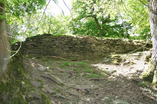
Still standing About the only part of
Aberedw castle that can be construed as a wall and in surprisingly good condition.
799:
784:
706:
606:
487:
470:
310:
925:
920:
42:
962:
369:
1061:
If the file has been modified from its original state, some details may not fully reflect the modified file.
953:
The following pages on the
English Knowledge (XXG) use this file (pages on other projects are not listed):
412:– If you remix, transform, or build upon the material, you must distribute your contributions under the
330:
on the
Geograph website for the photographer's contact details. The copyright on this image is owned by
936:
366:
828:"}},"text\/plain":{"en":{"P7787":"157 degree"}}}}": -->
643:"}},"text\/plain":{"en":{"P7787":"157 degree"}}}}": -->
91:
791:
776:
549:
167:
957:
294:
244:
335:
78:
183:
135:
278:
228:
156:
146:
315:
995:
327:
1010:
893:
Click on a date/time to view the file as it appeared at that time.
280:
230:
255:
205:
66:
1000:
985:
1035:
1015:
265:
52° 07′ 01″ N, 3° 21′ 01″ W
215:
52° 07′ 02″ N, 3° 21′ 02″ W
454:
Add a one-line explanation of what this file represents
1045:
110:
90:
Commons is a freely licensed media file repository.
968:
User:Robevans123/sandbox1/Welsh
Scheduled Monuments
623:
Creative
Commons Attribution-ShareAlike 2.0 Generic
56:(640 × 426 pixels, file size: 116 KB, MIME type:
423:https://creativecommons.org/licenses/by-sa/2.0
116:Still standing - geograph.org.uk - 1328127.jpg
71:
52:Still_standing_-_geograph.org.uk_-_1328127.jpg
429:Creative Commons Attribution-Share Alike 2.0
347:
8:
825:
640:
389:– to copy, distribute and transmit the work
1063:
895:
450:
978:The following other wikis use this file:
792:https://www.geograph.org.uk/photo/1328127
550:https://www.geograph.org.uk/profile/21460
1065:
955:
849:
833:
754:
738:
720:
704:
664:
648:
620:
604:
584:
568:
501:
485:
468:
465:
446:
439:
258:
208:
287:View this and other nearby images on:
237:View this and other nearby images on:
7:
334:and is licensed for reuse under the
884:
370:Attribution-Share Alike 2.0 Generic
358:
353:
338:Attribution-ShareAlike 2.0 license.
1056:
459:
453:
344:
321:
120:
103:
49:
458:
651:coordinates of the point of view
444:
400:Under the following conditions:
365:This file is licensed under the
357:
352:
346:
314:
293:
279:
271:
243:
229:
221:
70:
31:
21:
441:
121:
46:No higher resolution available.
14:
757:file available on the internet
440:
322:This image was taken from the
26:
1:
836:coordinates of depicted place
36:
807:Geograph Britain and Ireland
515:object of statement has role
466:Items portrayed in this file
270:
220:
982:Usage on ceb.wikipedia.org
1087:
1042:Usage on www.wikidata.org
1032:Usage on sv.wikipedia.org
1022:Usage on ru.wikipedia.org
1007:Usage on da.wikipedia.org
996:Defnyddiwr:Ham II/Henebion
992:Usage on cy.wikipedia.org
414:same or compatible license
196:Bill Nicholls /
177:Bill Nicholls /
885:
16:
963:List of castles in Wales
851:52°7'1.34"N, 3°21'0.72"W
770:geograph.org.uk image ID
666:52°7'1.99"N, 3°21'1.80"W
443:
380:
77:This is a file from the
1011:Borge og slotte i Wales
942:
921:22:49, 27 February 2011
168:required by the license
152:
141:
134:
131:
113:
81:. Information from its
328:this photograph's page
299:52.117040; -3.350200
249:52.117220; -3.350500
84:description page there
1026:Список замков Уэльса
395:– to adapt the work
530:author name string
1074:
1073:
974:Global file usage
946:
827:
642:
607:copyright license
452:
343:
342:
326:collection. See
304:
303:
254:
253:
203:
202:
171:
99:
98:
79:Wikimedia Commons
32:Global file usage
1078:
1064:
933:
873:
872:
867:
809:
804:
794:
789:
785:described at URL
779:
774:
688:
687:
682:
571:copyright status
552:
547:
537:
534:
524:
519:
436:
433:
430:
427:
424:
416:as the original.
378:
367:Creative Commons
361:
360:
356:
355:
350:
349:
336:Creative Commons
324:Geograph project
318:
311:
300:
297:
283:
282:
276:
275:
274:
268:
267:
256:
250:
247:
233:
232:
226:
225:
224:
218:
217:
206:
165:
137:
125:
117:
111:
95:
74:
73:
67:
61:
59:
1086:
1085:
1081:
1080:
1079:
1077:
1076:
1075:
1052:
1001:Castell Aberedw
972:
954:
947:
939:
931:
887:
886:
883:
882:
881:
880:
879:
878:
877:
876:
875:
874:
870:
868:
865:
856:
855:
854:
852:
842:
841:
840:
838:
819:
818:
817:
816:
815:
814:
813:
812:
811:
810:
805:
802:
796:
795:
790:
787:
781:
780:
775:
772:
763:
762:
761:
759:
747:
746:
745:
743:
732:
731:
730:
729:
728:
727:
726:
725:
723:
713:
712:
711:
709:
698:
697:
696:
695:
694:
693:
692:
691:
690:
689:
685:
683:
680:
671:
670:
669:
667:
657:
656:
655:
653:
634:
633:
632:
631:
630:
629:
628:
627:
625:
613:
612:
611:
609:
598:
597:
596:
595:
594:
593:
592:
591:
589:
577:
576:
575:
573:
562:
561:
560:
559:
558:
557:
556:
555:
554:
553:
548:
545:
539:
538:
535:
532:
526:
525:
520:
517:
508:
507:
506:
504:
494:
493:
492:
490:
479:
478:
477:
476:
475:
473:
457:
456:
455:
438:
437:
434:
431:
428:
425:
422:
421:
379:
376:
373:
362:
339:
309:
298:
272:
263:
262:
259:Object location
248:
222:
213:
212:
209:Camera location
204:
193:
186:
174:
147:geograph.org.uk
127:
115:
108:
101:
100:
89:
88:
87:is shown below.
63:
57:
55:
48:
47:
12:
11:
5:
1084:
1082:
1072:
1071:
1068:
1055:
1051:
1050:
1049:
1048:
1040:
1039:
1038:
1036:Aberedw Castle
1030:
1029:
1028:
1020:
1019:
1018:
1016:Aberedw Castle
1013:
1005:
1004:
1003:
998:
990:
989:
988:
986:Aberedw Castle
976:
975:
971:
970:
965:
960:
958:Aberedw Castle
952:
951:
950:
945:
944:
941:
937:
934:
928:
923:
918:
914:
913:
910:
907:
904:
901:
898:
891:
890:
861:
860:
859:
858:
857:
853:
850:
848:
847:
846:
845:
844:
843:
839:
834:
832:
831:
830:
829:
823:
798:
797:
783:
782:
768:
767:
766:
765:
764:
760:
755:
753:
752:
751:
750:
749:
748:
744:
741:source of file
739:
737:
736:
735:
734:
733:
724:
721:
719:
718:
717:
716:
715:
714:
710:
705:
703:
702:
701:
700:
699:
676:
675:
674:
673:
672:
668:
665:
663:
662:
661:
660:
659:
658:
654:
649:
647:
646:
645:
644:
638:
626:
621:
619:
618:
617:
616:
615:
614:
610:
605:
603:
602:
601:
600:
599:
590:
585:
583:
582:
581:
580:
579:
578:
574:
569:
567:
566:
565:
564:
563:
541:
540:
528:
527:
513:
512:
511:
510:
509:
505:
502:
500:
499:
498:
497:
496:
495:
491:
486:
484:
483:
482:
481:
480:
474:
469:
467:
464:
463:
462:
461:
460:
449:
448:
445:
442:
420:
419:
418:
417:
407:
398:
397:
396:
390:
383:You are free:
374:
364:
363:
345:
341:
340:
319:
308:
305:
302:
301:
291:
285:
260:
252:
251:
241:
235:
210:
201:
200:
198:Still standing
194:
191:
188:
187:
182:
179:Still standing
175:
172:
160:
159:
154:
150:
149:
143:
139:
138:
133:
129:
128:
118:
109:
107:
104:
102:
97:
96:
75:
65:
64:
45:
41:
40:
39:
34:
29:
24:
19:
13:
10:
9:
6:
4:
3:
2:
1083:
1069:
1066:
1062:
1059:
1053:
1047:
1044:
1043:
1041:
1037:
1034:
1033:
1031:
1027:
1024:
1023:
1021:
1017:
1014:
1012:
1009:
1008:
1006:
1002:
999:
997:
994:
993:
991:
987:
984:
983:
981:
980:
979:
973:
969:
966:
964:
961:
959:
956:
948:
940:
935:
929:
927:
924:
922:
919:
916:
915:
911:
908:
905:
902:
899:
897:
896:
894:
888:
864:
837:
808:
801:
793:
786:
778:
771:
758:
742:
708:
679:
652:
624:
608:
588:
572:
551:
544:
536:Bill Nicholls
531:
523:
516:
489:
472:
426:CC BY-SA 2.0
415:
411:
408:
405:
402:
401:
399:
394:
391:
388:
385:
384:
382:
381:
377:Bill Nicholls
375:Attribution:
371:
368:
351:
337:
333:
332:Bill Nicholls
329:
325:
320:
317:
313:
312:
306:
296:
292:
290:
289:OpenStreetMap
286:
284:
266:
261:
257:
246:
242:
240:
239:OpenStreetMap
236:
234:
216:
211:
207:
199:
195:
190:
189:
185:
181: /
180:
176:
169:
164:
162:
161:
158:
157:Bill Nicholls
155:
151:
148:
144:
140:
130:
124:
119:
112:
105:
93:
86:
85:
80:
76:
69:
68:
62:
53:
44:
38:
35:
33:
30:
28:
25:
23:
20:
18:
15:
1060:
1057:
977:
892:
889:File history
522:photographer
409:
403:
392:
386:
331:
269:
219:
197:
184:CC BY-SA 2.0
178:
122:
92:You can help
82:
50:
22:File history
938:GeographBot
722:24 May 2009
587:copyrighted
410:share alike
404:attribution
163:Attribution
136:24 May 2009
114:Description
1067:_error
949:File usage
930:640 × 426
906:Dimensions
503:some value
58:image/jpeg
27:File usage
903:Thumbnail
900:Date/Time
707:inception
307:Licensing
192:InfoField
173:InfoField
123:English:
1054:Metadata
1046:Q4667054
932:(116 KB)
800:operator
447:Captions
393:to remix
387:to share
372:license.
37:Metadata
917:current
912:Comment
863:heading
822:heading
777:1328127
678:heading
637:heading
488:creator
471:depicts
451:English
106:Summary
54:
871:degree
826:degree
686:degree
641:degree
277:
227:
153:Author
142:Source
145:From
909:User
869:157
684:157
435:true
432:true
132:Date
17:File
543:URL
866::
803::
788::
773::
681::
546::
533::
518::
1070:0
170:)
166:(
94:.
60:)
Text is available under the Creative Commons Attribution-ShareAlike License. Additional terms may apply.
_heading:157.00&language=en)
_heading:157.00&language=en)
