115:
302:
211:
225:
314:
266:
72:
577:
594:{{BotMoveToCommons|en.wikipedia|year={{subst:CURRENTYEAR}}|month={{subst:CURRENTMONTHNAME}}|day={{subst:CURRENTDAY}}}} {{Information |Description={{en|Stone castle of Fort William Henry, with John's Bay and Island in distance, Pemaquid Beach, Bristol...
202:
43:
159:
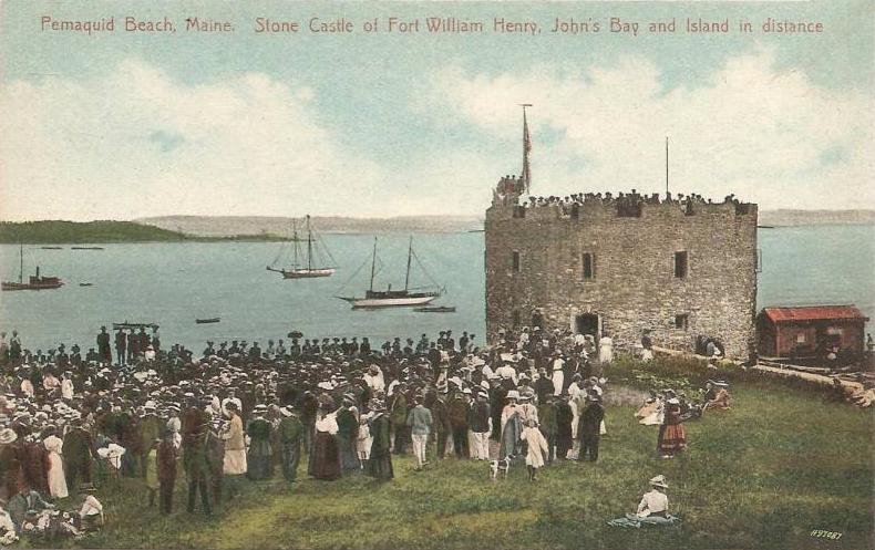
Stone castle of Fort
William Henry, with John's Bay and Island in distance, Pemaquid Beach, Bristol, Maine. It was originally built in 1692 but destroyed during King William's War in 1696. The tower was reconstructed in 1908 using many original
366:
Stone castle of Fort
William Henry, with John's Bay and Island in distance, Pemaquid Beach, Bristol, Maine; reproduced from an original 1909 postcard published by the Hugh C. Leighton Company, Portland, Maine.
51:
328:
for US works, such as Canada, Mainland China (not Hong Kong or Macao), Germany, Mexico, and
Switzerland. The creator and year of publication are essential information and must be provided. See
83:
324:
This image might not be in the public domain outside of the United States; this especially applies in the countries and areas that do not apply the
122:
576:
571:
218:
42:
641:
418:
674:
This file contains additional information, probably added from the digital camera or scanner used to create or digitize it.
508:
472:
488:
438:
402:
613:
618:
325:
329:
677:
If the file has been modified from its original state, some details may not fully reflect the modified file.
333:
361:
91:
179:
Reproduced from an original postcard published by the Hugh C. Leighton
Company, Portland, Maine
291:
290:
occurred prior to
January 1, 1929, and if not then due to lack of notice or renewal. See
608:
587:
278:
224:
286:. This applies to U.S. works where the copyright has expired, often because its first
131:
623:
78:
287:
208:
283:
109:
169:
544:
Click on a date/time to view the file as it appeared at that time.
126:
210:
501:
260:
193:
121:
This is an image of a place or building that is listed on the
66:
651:
312:
300:
264:
203:
43° 52′ 39″ N, 69° 31′ 29″ W
149:
Stone Castle of Fort
William Henry, Pemaquid Beach, ME.jpg
52:
Stone_Castle_of_Fort_William_Henry,_Pemaquid_Beach,_ME.jpg
386:
Add a one-line explanation of what this file represents
353:
661:
143:
90:
Commons is a freely licensed media file repository.
356:. All following user names refer to en.wikipedia.
56:(790 × 497 pixels, file size: 77 KB, MIME type:
71:
8:
679:
546:
382:
240:
634:The following other wikis use this file:
681:
606:
522:
506:
486:
470:
452:
436:
416:
400:
397:
378:
371:
196:
217:View this and other nearby images on:
686:d By eBay with ImageMagick, R1.0.1.M1
604:The following 4 pages use this file:
301:
265:
7:
123:National Register of Historic Places
535:
672:
391:
385:
352:The original description page was
351:
323:
274:
153:
103:
49:
390:
376:
223:
209:
113:
70:
31:
21:
373:
154:
46:No higher resolution available.
14:
372:
26:
1:
509:coordinates of depicted place
36:
398:Items portrayed in this file
638:Usage on arz.wikipedia.org
703:
658:Usage on www.wikidata.org
648:Usage on it.wikipedia.org
614:Fort William Henry (Maine)
524:43°52'39.0"N, 69°31'28.9"W
276:This media file is in the
129:. Its reference number is
619:List of Maine state parks
536:
16:
375:
326:rule of the shorter term
294:for further explanation.
127:United States of America
77:This is a file from the
593:
364:790×497× (78769 bytes)
330:Knowledge:Public domain
183:
175:
168:
165:
146:
81:. Information from its
317:
306:
270:
229:43.877500; -69.524722
84:description page there
316:
304:
268:
473:location of creation
334:Knowledge:Copyrights
187:Unknown photographer
572:19:28, 13 July 2012
348:Original upload log
419:Fort William Henry
318:
307:
271:
690:
689:
630:Global file usage
597:
384:
360:2011-01-12 15:10
345:
344:
338:
336:for more details.
259:
258:
234:
233:
191:
190:
141:
140:
99:
98:
79:Wikimedia Commons
32:Global file usage
694:
680:
584:
339:
322:
315:
303:
267:
261:
255:
252:
249:
246:
241:
230:
227:
213:
212:
206:
205:
194:
171:
158:
150:
144:
134:
117:
116:
110:
95:
74:
73:
67:
61:
59:
702:
701:
697:
696:
695:
693:
692:
691:
668:
652:Bristol (Maine)
642:حصن ويليام هنرى
628:
598:
590:
582:
538:
537:
534:
533:
532:
531:
530:
529:
528:
527:
525:
515:
514:
513:
511:
500:
499:
498:
497:
496:
495:
494:
493:
491:
479:
478:
477:
475:
464:
463:
462:
461:
460:
459:
458:
457:
455:
445:
444:
443:
441:
430:
429:
428:
427:
426:
425:
424:
423:
421:
409:
408:
407:
405:
389:
388:
387:
357:
350:
337:
321:
313:
296:
253:
250:
247:
244:
239:
228:
201:
200:
197:Object location
192:
161:
148:
130:
114:
108:
101:
100:
89:
88:
87:is shown below.
63:
57:
55:
48:
47:
12:
11:
5:
700:
698:
688:
687:
684:
671:
667:
666:
665:
664:
656:
655:
654:
646:
645:
644:
632:
631:
627:
626:
621:
616:
611:
609:Bristol, Maine
602:
601:
596:
595:
592:
588:
585:
579:
574:
569:
565:
564:
561:
558:
555:
552:
549:
542:
541:
526:
523:
521:
520:
519:
518:
517:
516:
512:
507:
505:
504:
503:
502:
492:
487:
485:
484:
483:
482:
481:
480:
476:
471:
469:
468:
467:
466:
465:
456:
453:
451:
450:
449:
448:
447:
446:
442:
437:
435:
434:
433:
432:
431:
422:
417:
415:
414:
413:
412:
411:
410:
406:
401:
399:
396:
395:
394:
393:
392:
381:
380:
377:
374:
370:
369:
349:
346:
343:
342:
340:
319:
309:
308:
298:
272:
257:
256:
238:
235:
232:
231:
221:
215:
198:
189:
188:
185:
181:
180:
177:
173:
172:
167:
163:
162:
151:
142:
139:
138:
118:
107:
104:
102:
97:
96:
75:
65:
64:
45:
41:
40:
39:
34:
29:
24:
19:
13:
10:
9:
6:
4:
3:
2:
699:
685:
683:User comments
682:
678:
675:
669:
663:
660:
659:
657:
653:
650:
649:
647:
643:
640:
639:
637:
636:
635:
629:
625:
624:William Phips
622:
620:
617:
615:
612:
610:
607:
605:
599:
591:
586:
580:
578:
575:
573:
570:
567:
566:
562:
559:
556:
553:
550:
548:
547:
545:
539:
510:
490:
474:
440:
420:
404:
368:
363:
359:
358:
355:
347:
341:
335:
331:
327:
320:
311:
310:
305:United States
299:
297:
295:
293:
289:
285:
284:United States
281:
280:
279:public domain
273:
269:Public domain
263:
262:
248:Public domain
245:Public domain
243:
242:
236:
226:
222:
220:
219:OpenStreetMap
216:
214:
204:
199:
195:
186:
182:
178:
174:
164:
157:
152:
145:
137:
136:
133:
128:
124:
119:
112:
111:
105:
93:
86:
85:
80:
76:
69:
68:
62:
53:
44:
38:
35:
33:
30:
28:
25:
23:
20:
18:
15:
676:
673:
633:
603:
543:
540:File history
365:
362:Hugh Manatee
277:
275:
155:
120:
92:You can help
82:
50:
22:File history
288:publication
147:Description
600:File usage
581:790 × 497
557:Dimensions
58:image/jpeg
27:File usage
589:MGA73bot2
554:Thumbnail
551:Date/Time
439:inception
292:this page
237:Licensing
156:English:
670:Metadata
662:Q5472349
379:Captions
132:69000021
37:Metadata
583:(77 KB)
568:current
563:Comment
403:depicts
383:English
282:in the
160:stones.
125:in the
106:Summary
54:
207:
184:Author
176:Source
489:Maine
254:false
251:false
560:User
454:1909
354:here
332:and
170:1909
166:Date
17:File
135:.
94:.
60:)
Text is available under the Creative Commons Attribution-ShareAlike License. Additional terms may apply.