359:
38:
292:
242:
284:
234:
306:
256:
327:
365:
370:
82:
835:"}},"text\/plain":{"en":{"":"heading"}}},"{\"value\":{\"amount\":\"+90\",\"unit\":\"http:\\\/\\\/www.wikidata.org\\\/entity\\\/Q28390\"},\"type\":\"quantity\"}":{"text\/html":{"en":{"P7787":"90
684:"}},"text\/plain":{"en":{"":"heading"}}},"{\"value\":{\"amount\":\"+90\",\"unit\":\"http:\\\/\\\/www.wikidata.org\\\/entity\\\/Q28390\"},\"type\":\"quantity\"}":{"text\/html":{"en":{"P7787":"90
937:
831:
225:
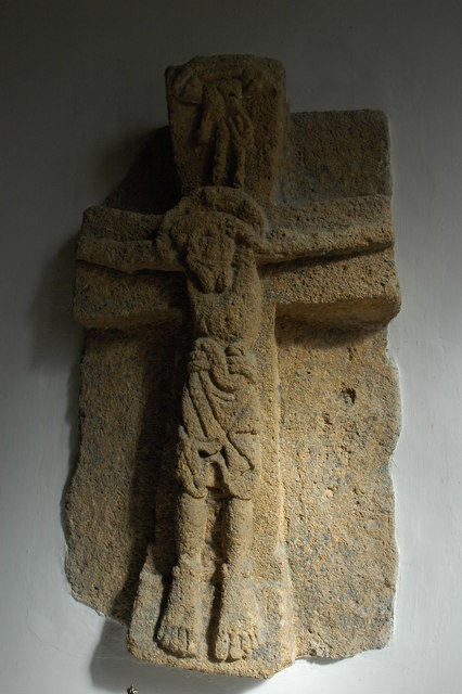
954:== {{int:filedesc}} == {{Information |description={{en|1=Stone crucifix, Wormington Church This carved stone crucifix mounted in the wall of Wormington church is Saxon, dating from around 1020-1050; it was found at Wormington Grange and is thought that it
136:
Stone crucifix, Wormington Church This carved stone crucifix mounted in the wall of
Wormington church is Saxon, dating from around 1020-1050; it was found at Wormington Grange and is thought that it may originate from Winchcombe
417:– You must give appropriate credit, provide a link to the license, and indicate if changes were made. You may do so in any reasonable manner, but not in any way that suggests the licensor endorses you or your use.
48:
42:
93:
61:
832:
681:
936:
931:
52:
37:
767:
633:
597:
299:
249:
787:
334:
979:
This file contains additional information, probably added from the digital camera or scanner used to create or digitize it.
424:
560:
873:
846:
795:
751:
722:
695:
581:
553:
538:
525:
810:
780:
653:
617:
498:
481:
321:
380:
982:
If the file has been modified from its original state, some details may not fully reflect the modified file.
964:
The following pages on the
English Knowledge (XXG) use this file (pages on other projects are not listed):
423:– If you remix, transform, or build upon the material, you must distribute your contributions under the
341:
on the
Geograph website for the photographer's contact details. The copyright on this image is owned by
947:
377:
839:"}},"text\/plain":{"en":{"P7787":"90 degree"}}}}": -->
688:"}},"text\/plain":{"en":{"P7787":"90 degree"}}}}": -->
101:
194:
968:
817:
802:
545:
178:
305:
255:
346:
88:
146:
289:
239:
157:
167:
326:
338:
904:
Click on a date/time to view the file as it appeared at that time.
126:
Stone crucifix, Wormington Church - geograph.org.uk - 1780268.jpg
291:
241:
266:
216:
76:
276:
52° 01′ 34″ N, 1° 56′ 40″ W
226:
52° 01′ 34″ N, 1° 56′ 41″ W
465:
Add a one-line explanation of what this file represents
120:
100:
Commons is a freely licensed media file repository.
634:
Creative
Commons Attribution-ShareAlike 2.0 Generic
66:(426 × 640 pixels, file size: 61 KB, MIME type:
434:https://creativecommons.org/licenses/by-sa/2.0
81:
440:Creative Commons Attribution-Share Alike 2.0
358:
8:
836:
685:
400:– to copy, distribute and transmit the work
984:
906:
461:
818:https://www.geograph.org.uk/photo/1780268
546:https://www.geograph.org.uk/profile/1837
986:
966:
860:
844:
765:
749:
709:
693:
667:
651:
631:
615:
595:
579:
512:
496:
479:
476:
457:
450:
269:
219:
298:View this and other nearby images on:
248:View this and other nearby images on:
7:
345:and is licensed for reuse under the
895:
381:Attribution-Share Alike 2.0 Generic
369:
364:
349:Attribution-ShareAlike 2.0 license.
977:
470:
464:
355:
332:
130:
113:
59:
469:
209:Stone crucifix, Wormington Church
190:Stone crucifix, Wormington Church
696:coordinates of the point of view
455:
411:Under the following conditions:
376:This file is licensed under the
368:
363:
357:
325:
304:
290:
282:
254:
240:
232:
80:
21:
452:
131:
14:
768:file available on the internet
451:
333:This image was taken from the
26:
1:
847:coordinates of depicted place
31:
788:Geograph Britain and Ireland
554:object of statement has role
477:Items portrayed in this file
281:
231:
207:Philip Halling /
188:Philip Halling /
1008:
862:52°1'34.10"N, 1°56'40.20"W
711:52°1'34.10"N, 1°56'41.28"W
425:same or compatible license
896:
16:
796:geograph.org.uk image ID
454:
391:
87:This is a file from the
953:
179:required by the license
163:
152:
145:
142:
123:
91:. Information from its
339:this photograph's page
310:52.026140; -1.944500
260:52.026140; -1.944800
94:description page there
41:Size of this preview:
932:12:16, 14 March 2011
406:– to adapt the work
47:Other resolutions:
526:author name string
995:
994:
957:
838:
687:
618:copyright license
463:
354:
353:
337:collection. See
315:
314:
265:
264:
214:
213:
182:
109:
108:
89:Wikimedia Commons
999:
985:
969:Winchcombe Abbey
944:
884:
883:
878:
820:
815:
811:described at URL
805:
800:
790:
785:
733:
732:
727:
582:copyright status
563:
558:
548:
543:
533:
530:
447:
444:
441:
438:
435:
427:as the original.
389:
378:Creative Commons
372:
371:
367:
366:
361:
360:
347:Creative Commons
335:Geograph project
329:
322:
311:
308:
294:
293:
287:
286:
285:
279:
278:
267:
261:
258:
244:
243:
237:
236:
235:
229:
228:
217:
176:
148:
135:
127:
121:
105:
84:
83:
77:
71:
69:
56:
53:426 × 640 pixels
49:160 × 240 pixels
43:399 × 599 pixels
1007:
1006:
1002:
1001:
1000:
998:
997:
996:
973:
965:
958:
950:
942:
898:
897:
894:
893:
892:
891:
890:
889:
888:
887:
886:
885:
881:
879:
876:
867:
866:
865:
863:
853:
852:
851:
849:
830:
829:
828:
827:
826:
825:
824:
823:
822:
821:
816:
813:
807:
806:
801:
798:
792:
791:
786:
783:
774:
773:
772:
770:
758:
757:
756:
754:
743:
742:
741:
740:
739:
738:
737:
736:
735:
734:
730:
728:
725:
716:
715:
714:
712:
702:
701:
700:
698:
679:
678:
677:
676:
675:
674:
673:
672:
670:
660:
659:
658:
656:
645:
644:
643:
642:
641:
640:
639:
638:
636:
624:
623:
622:
620:
609:
608:
607:
606:
605:
604:
603:
602:
600:
588:
587:
586:
584:
573:
572:
571:
570:
569:
568:
567:
566:
565:
564:
559:
556:
550:
549:
544:
541:
535:
534:
531:
528:
519:
518:
517:
515:
505:
504:
503:
501:
490:
489:
488:
487:
486:
484:
468:
467:
466:
449:
448:
445:
442:
439:
436:
433:
432:
390:
387:
384:
373:
350:
320:
309:
283:
274:
273:
270:Object location
259:
233:
224:
223:
220:Camera location
215:
204:
197:
185:
158:geograph.org.uk
138:
125:
118:
111:
110:
99:
98:
97:is shown below.
73:
67:
65:
58:
57:
46:
12:
11:
5:
1005:
1003:
993:
992:
989:
976:
972:
971:
963:
962:
961:
956:
955:
952:
948:
945:
939:
934:
929:
925:
924:
921:
918:
915:
912:
909:
902:
901:
872:
871:
870:
869:
868:
864:
861:
859:
858:
857:
856:
855:
854:
850:
845:
843:
842:
841:
840:
834:
809:
808:
794:
793:
779:
778:
777:
776:
775:
771:
766:
764:
763:
762:
761:
760:
759:
755:
752:source of file
750:
748:
747:
746:
745:
744:
721:
720:
719:
718:
717:
713:
710:
708:
707:
706:
705:
704:
703:
699:
694:
692:
691:
690:
689:
683:
671:
668:
666:
665:
664:
663:
662:
661:
657:
652:
650:
649:
648:
647:
646:
637:
632:
630:
629:
628:
627:
626:
625:
621:
616:
614:
613:
612:
611:
610:
601:
596:
594:
593:
592:
591:
590:
589:
585:
580:
578:
577:
576:
575:
574:
552:
551:
537:
536:
532:Philip Halling
524:
523:
522:
521:
520:
516:
513:
511:
510:
509:
508:
507:
506:
502:
497:
495:
494:
493:
492:
491:
485:
480:
478:
475:
474:
473:
472:
471:
460:
459:
456:
453:
431:
430:
429:
428:
418:
409:
408:
407:
401:
394:You are free:
388:Philip Halling
385:
375:
374:
356:
352:
351:
343:Philip Halling
330:
319:
316:
313:
312:
302:
296:
271:
263:
262:
252:
246:
221:
212:
211:
205:
202:
199:
198:
193:
186:
183:
171:
170:
168:Philip Halling
165:
161:
160:
154:
150:
149:
144:
140:
139:
128:
119:
117:
114:
112:
107:
106:
85:
75:
74:
40:
36:
35:
34:
29:
24:
19:
13:
10:
9:
6:
4:
3:
2:
1004:
990:
987:
983:
980:
974:
970:
967:
959:
951:
946:
940:
938:
935:
933:
930:
927:
926:
922:
919:
916:
913:
910:
908:
907:
905:
899:
875:
848:
819:
812:
804:
797:
789:
782:
769:
753:
724:
697:
669:28 March 2010
655:
635:
619:
599:
583:
562:
555:
547:
540:
527:
500:
483:
437:CC BY-SA 2.0
426:
422:
419:
416:
413:
412:
410:
405:
402:
399:
396:
395:
393:
392:
386:Attribution:
382:
379:
362:
348:
344:
340:
336:
331:
328:
324:
323:
317:
307:
303:
301:
300:OpenStreetMap
297:
295:
277:
272:
268:
257:
253:
251:
250:OpenStreetMap
247:
245:
227:
222:
218:
210:
206:
201:
200:
196:
192: /
191:
187:
180:
175:
173:
172:
169:
166:
162:
159:
155:
151:
147:28 March 2010
141:
134:
129:
122:
115:
103:
96:
95:
90:
86:
79:
78:
72:
63:
62:Original file
54:
50:
44:
39:
33:
30:
28:
25:
23:
20:
18:
15:
981:
978:
903:
900:File history
561:photographer
420:
414:
403:
397:
342:
280:
230:
208:
195:CC BY-SA 2.0
189:
132:
102:You can help
92:
60:
22:File history
949:GeographBot
598:copyrighted
421:share alike
415:attribution
174:Attribution
124:Description
988:_error
960:File usage
941:426 × 640
917:Dimensions
514:some value
68:image/jpeg
27:File usage
914:Thumbnail
911:Date/Time
654:inception
318:Licensing
203:InfoField
184:InfoField
133:English:
975:Metadata
781:operator
458:Captions
404:to remix
398:to share
383:license.
32:Metadata
943:(61 KB)
928:current
923:Comment
874:heading
833:heading
803:1780268
723:heading
682:heading
499:creator
482:depicts
462:English
116:Summary
64:
882:degree
837:degree
731:degree
686:degree
288:
238:
164:Author
153:Source
137:Abbey.
156:From
920:User
446:true
443:true
143:Date
17:File
880:90
729:90
539:URL
877::
814::
799::
784::
726::
557::
542::
529::
51:|
45:.
991:0
181:)
177:(
104:.
70:)
55:.
Text is available under the Creative Commons Attribution-ShareAlike License. Additional terms may apply.
_heading:90.00&language=en)
_heading:90.00&language=en)
