297:
43:
207:
245:
221:
99:
646:
364:
Information that has not been accessed by way of publication or disclosure under information access legislation (including the
Freedom of Information Acts for the UK and Scotland) by or with the consent of the Information
338:
acknowledge the source of the
Information in your product or application by including or linking to any attribution statement specified by the Information Provider(s) and, where possible, provide a link to this
198:
396:
Note: Since 2010, almost all information owned by the UK Crown is offered for use and re-use under the Open
Government Licence by authority of The Controller of His Majesty's Stationery Office.
328:
exploit the
Information commercially and non-commercially for example, by combining it with other Information, or by including it in your own product or application.
73:
69:
65:
61:
57:
53:
47:
110:
256:
82:
717:
368:
departmental or public sector organisation logos, crests and the Royal Arms except where they form an integral part of a document or dataset;
900:
523:
487:
296:
214:
923:
This file contains additional information, probably added from the digital camera or scanner used to create or digitize it.
543:
471:
282:
https://www.ordnancesurvey.co.uk/business-and-government/licensing/using-creating-data-with-os-products/os-opendata.html
260:
In short: you are free to distribute and modify the file as long as you attribute (including year), the
Ordnance Survey.
577:
507:
454:
153:
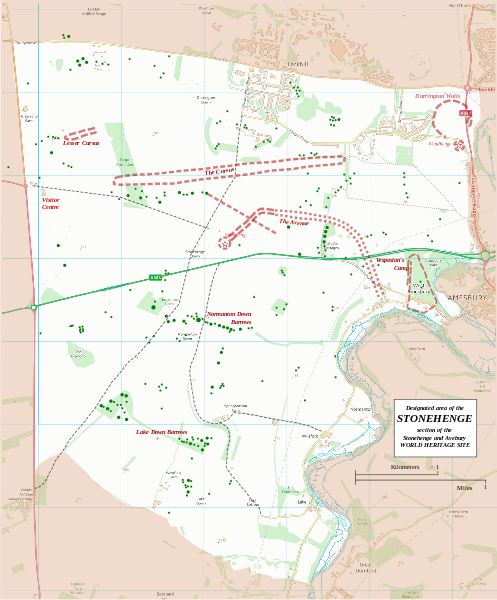
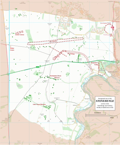
Boundary and key sites on the
Avebury section of the Stonehenge, Avebury and Associated Sites World Heritage Site
926:
If the file has been modified from its original state, some details may not fully reflect the modified file.
386:
303:
732:
712:
645:
640:
342:
If the
Information Provider does not provide a specific attribution statement, you must use the following:
42:
865:
737:
673:
The following pages on the
English Knowledge use this file (pages on other projects are not listed):
835:
656:
118:
790:
727:
722:
687:
291:
239:
707:
252:
890:
692:
377:
other intellectual property rights, including patents, trade marks, and design rights; and
271:
Note: Derivative works can be licensed under any
Creative Commons Attribution 3.0 Licence.
232:
Principal monuments and earthworks are shown in Red. Barrows are indicated by green dots.
855:
702:
220:
105:
697:
347:
Contains public sector information licensed under the Open
Government Licence v3.0.
682:
162:
677:
742:
204:
374:
third party rights the Information Provider is not authorised to license;
265:
Contains Ordnance Survey data © Crown copyright and database right (year)
910:
414:
http://www.nationalarchives.gov.uk/doc/open-government-licence/version/3
183:
RobinLeicester building on OS OpenData VextorMap District Raster files
173:
613:
Click on a date/time to view the file as it appeared at that time.
401:
880:
815:
805:
206:
810:
189:
93:
87:(SVG file, nominally 1,438 × 1,736 pixels, file size: 1.57 MB)
775:
780:
199:
51° 10′ 40.8″ N, 1° 49′ 30″ W
875:
845:
536:
825:
800:
770:
760:
438:
Add a one-line explanation of what this file represents
322:
copy, publish, distribute and transmit the Information;
137:
117:
Commons is a freely licensed media file repository.
380:identity documents such as the British Passport.
302:This file is licensed under the United Kingdom
172:OS Open Data with additional material cited at
791:Stonehenge, Avebury ja niihin liittyvät paikat
98:
891:Stonehenge, Avebury in z njimi povezana mesta
8:
856:Stonehenge, Avebury en bijbehorende plaatsen
404:for information on usage on Wikimedia wikis.
46:Size of this PNG preview of this SVG file:
928:
615:
434:
753:The following other wikis use this file:
718:Stonehenge, Avebury and Associated Sites
334:You must, where you do any of the above:
143:Stonehenge World Heritage Site map 2.svg
938:
930:
675:
591:
575:
557:
541:
521:
505:
485:
469:
452:
449:
430:
423:
192:
213:View this and other nearby images on:
7:
663:User created page with UploadWizard
604:
921:
443:
437:
270:
255:of the United Kingdom under their
147:
130:
80:
442:
361:personal data in the Information;
544:coordinates of the point of view
428:
295:
276:Ordnance Survey OpenData Licence
243:
219:
205:
97:
31:
21:
425:
174:World Heritage Site list No 373
148:
14:
872:Usage on simple.wikipedia.org
424:
26:
1:
251:This file is licensed by the
36:
524:Open Government Licence v3.0
450:Items portrayed in this file
304:Open Government Licence v3.0
822:Usage on fr.wikivoyage.org
960:
907:Usage on zh.wikipedia.org
897:Usage on ur.wikipedia.org
887:Usage on sl.wikipedia.org
862:Usage on ru.wikipedia.org
852:Usage on nl.wikipedia.org
842:Usage on kw.wikipedia.org
832:Usage on ja.wikipedia.org
797:Usage on fr.wikipedia.org
787:Usage on fi.wikipedia.org
767:Usage on de.wikipedia.org
757:Usage on cs.wikipedia.org
605:
408:Open Government License 3
294:
16:
427:
104:This is a file from the
662:
179:
168:
161:
158:
140:
108:. Information from its
733:Stonehenge road tunnel
713:Normanton Down Barrows
641:22:36, 13 January 2015
325:adapt the Information;
225:51.178000; -1.825000
111:description page there
738:Vespasian's Camp
559:51°10'41"N, 1°49'30"W
74:1,438 × 1,736 pixels
70:1,696 × 2,048 pixels
816:Avenue (Stonehenge)
806:Cursus (Stonehenge)
257:OS OpenData License
52:Other resolutions:
371:military insignia;
353:This licence does
66:848 × 1,024 pixels
947:
946:
811:Camp de Vespasien
749:Global file usage
728:Stonehenge Cursus
723:Stonehenge Avenue
688:Coneybury Anomaly
666:
508:copyright license
436:
422:
421:
406:
389:for full details.
290:
289:
273:
230:
229:
187:
186:
126:
125:
106:Wikimedia Commons
32:Global file usage
951:
929:
881:Durrington Walls
776:Durrington Walls
708:Durrington Walls
653:
472:copyright status
418:
415:
412:
409:
394:
318:You are free to:
299:
292:
286:
283:
280:
277:
269:
266:
247:
246:
240:
226:
223:
209:
208:
202:
201:
190:
164:
152:
144:
138:
122:
101:
100:
94:
88:
77:
62:636 × 768 pixels
58:398 × 480 pixels
54:199 × 240 pixels
48:497 × 600 pixels
959:
958:
954:
953:
952:
950:
949:
948:
917:
901:ڈورنگٹن دیواریں
747:
693:Coneybury Henge
674:
667:
659:
651:
607:
606:
603:
602:
601:
600:
599:
598:
597:
596:
594:
593:13 January 2015
584:
583:
582:
580:
569:
568:
567:
566:
565:
564:
563:
562:
560:
550:
549:
548:
546:
535:
534:
533:
532:
531:
530:
529:
528:
526:
514:
513:
512:
510:
499:
498:
497:
496:
495:
494:
493:
492:
490:
478:
477:
476:
474:
463:
462:
461:
460:
459:
457:
441:
440:
439:
416:
413:
410:
407:
405:
284:
281:
278:
275:
274:
272:
264:
253:Ordnance Survey
244:
238:
224:
197:
196:
193:Camera location
188:
163:13 January 2015
154:
142:
135:
128:
127:
116:
115:
114:is shown below.
90:
86:
79:
78:
51:
12:
11:
5:
957:
955:
945:
944:
941:
937:
936:
933:
920:
916:
915:
914:
913:
905:
904:
903:
895:
894:
893:
885:
884:
883:
878:
870:
869:
868:
860:
859:
858:
850:
849:
848:
840:
839:
838:
830:
829:
828:
820:
819:
818:
813:
808:
803:
795:
794:
793:
785:
784:
783:
781:Normanton Down
778:
773:
765:
764:
763:
751:
750:
746:
745:
740:
735:
730:
725:
720:
715:
710:
705:
703:Cursus Barrows
700:
695:
690:
685:
680:
672:
671:
670:
665:
664:
661:
658:RobinLeicester
657:
654:
650:1,438 × 1,736
648:
643:
638:
634:
633:
630:
627:
624:
621:
618:
611:
610:
595:
592:
590:
589:
588:
587:
586:
585:
581:
576:
574:
573:
572:
571:
570:
561:
558:
556:
555:
554:
553:
552:
551:
547:
542:
540:
539:
538:
537:
527:
522:
520:
519:
518:
517:
516:
515:
511:
506:
504:
503:
502:
501:
500:
491:
486:
484:
483:
482:
481:
480:
479:
475:
470:
468:
467:
466:
465:
464:
458:
453:
451:
448:
447:
446:
445:
444:
433:
432:
429:
426:
420:
419:
399:
393:
392:
391:
390:
382:
381:
378:
375:
372:
369:
366:
362:
350:
349:
348:
344:
343:
340:
331:
330:
329:
326:
323:
312:
311:
308:
307:
300:
288:
287:
250:
248:
237:
234:
228:
227:
217:
211:
194:
185:
184:
181:
177:
176:
170:
166:
165:
160:
156:
155:
145:
136:
134:
131:
129:
124:
123:
102:
92:
91:
45:
41:
40:
39:
34:
29:
24:
19:
13:
10:
9:
6:
4:
3:
2:
956:
942:
939:
934:
931:
927:
924:
918:
912:
909:
908:
906:
902:
899:
898:
896:
892:
889:
888:
886:
882:
879:
877:
874:
873:
871:
867:
864:
863:
861:
857:
854:
853:
851:
847:
846:Dons an Gewri
844:
843:
841:
837:
834:
833:
831:
827:
824:
823:
821:
817:
814:
812:
809:
807:
804:
802:
799:
798:
796:
792:
789:
788:
786:
782:
779:
777:
774:
772:
769:
768:
766:
762:
759:
758:
756:
755:
754:
748:
744:
741:
739:
736:
734:
731:
729:
726:
724:
721:
719:
716:
714:
711:
709:
706:
704:
701:
699:
696:
694:
691:
689:
686:
684:
681:
679:
676:
668:
660:
655:
649:
647:
644:
642:
639:
636:
635:
631:
628:
625:
622:
619:
617:
616:
614:
608:
579:
545:
525:
509:
489:
473:
456:
403:
398:
397:
388:
384:
383:
379:
376:
373:
370:
367:
363:
360:
359:
358:
356:
351:
346:
345:
341:
337:
336:
335:
332:
327:
324:
321:
320:
319:
316:
315:
314:
313:
310:
309:
305:
301:
298:
293:
268:
267:
263:Attribution:
261:
259:
258:
254:
249:
242:
241:
235:
233:
222:
218:
216:
215:OpenStreetMap
212:
210:
200:
195:
191:
182:
178:
175:
171:
167:
157:
151:
146:
139:
132:
120:
113:
112:
107:
103:
96:
95:
89:
84:
83:Original file
75:
71:
67:
63:
59:
55:
49:
44:
38:
35:
33:
30:
28:
25:
23:
20:
18:
15:
925:
922:
752:
698:Cuckoo Stone
612:
609:File history
395:
354:
352:
333:
317:
262:
231:
149:
119:You can help
109:
81:
22:File history
683:Bush Barrow
488:copyrighted
279:OS OpenData
141:Description
866:Стоунхендж
826:Stonehenge
801:Stonehenge
771:Stonehenge
761:Stonehenge
678:Blick Mead
669:File usage
626:Dimensions
400:See also:
387:this guide
27:File usage
943:1736.3279
935:1437.9901
876:Woodhenge
743:Woodhenge
652:(1.57 MB)
623:Thumbnail
620:Date/Time
578:inception
365:Provider;
236:Licensing
150:English:
919:Metadata
431:Captions
385:Consult
339:licence;
37:Metadata
637:current
632:Comment
455:depicts
435:English
133:Summary
85:
940:Height
836:ウッドヘンジ
357:cover:
203:
180:Author
169:Source
932:Width
411:OGL 3
629:User
417:true
402:Meta
285:true
159:Date
17:File
911:巨木陣
355:NOT
306:.
72:|
68:|
64:|
60:|
56:|
50:.
121:.
76:.
Text is available under the Creative Commons Attribution-ShareAlike License. Additional terms may apply.

_(St_Edwards_Crown).svg)