286:
219:
233:
254:
292:
297:
67:
770:
121:
Street: Upper
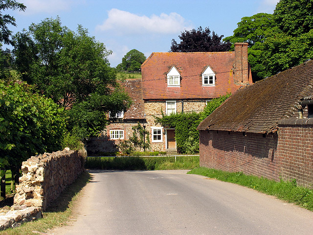
Lambourn. Upper Lambourn occupies the north-west to south-east diagonal through the square. This view of the intersection of the road (running north east off the B road) and the minor road that rejoins the B road, is in the centre of the square. The square is farmland and
210:
787:== {{int:filedesc}} == {{Information |description={{en|1=Street: Upper Lambourn. Upper Lambourn occupies the north-west to south-east diagonal through the square. This view of the intersection of the road (running north east off the B road) and the minor
38:
344:– You must give appropriate credit, provide a link to the license, and indicate if changes were made. You may do so in any reasonable manner, but not in any way that suggests the licensor endorses you or your use.
78:
46:
596:
560:
524:
226:
631:
261:
812:
This file contains additional information, probably added from the digital camera or scanner used to create or digitize it.
351:
459:
769:
764:
701:
609:
580:
508:
480:
467:
452:
37:
667:
639:
624:
544:
425:
408:
248:
307:
815:
If the file has been modified from its original state, some details may not fully reflect the modified file.
350:– If you remix, transform, or build upon the material, you must distribute your contributions under the
268:
on the
Geograph website for the photographer's contact details. The copyright on this image is owned by
780:
304:
797:
The following pages on the
English Knowledge use this file (pages on other projects are not listed):
86:
179:
163:
646:
616:
487:
801:
232:
273:
73:
216:
131:
142:
253:
152:
265:
737:
Click on a date/time to view the file as it appeared at that time.
694:
218:
211:
51° 31′ 10.85″ N, 1° 32′ 50.8″ W
201:
61:
392:
Add a one-line explanation of what this file represents
111:
Street, Upper
Lambourn - geograph.org.uk - 25927.jpg
105:
85:
Commons is a freely licensed media file repository.
47:
Street,_Upper_Lambourn_-_geograph.org.uk_-_25927.jpg
561:
Creative
Commons Attribution-ShareAlike 2.0 Generic
51:(640 × 480 pixels, file size: 185 KB, MIME type:
361:https://creativecommons.org/licenses/by-sa/2.0
66:
367:Creative Commons Attribution-Share Alike 2.0
285:
8:
327:– to copy, distribute and transmit the work
817:
739:
388:
819:
799:
715:
699:
681:
665:
647:https://www.geograph.org.uk/photo/25927
594:
578:
558:
542:
522:
506:
439:
423:
406:
403:
384:
377:
204:
488:https://www.geograph.org.uk/profile/40
225:View this and other nearby images on:
7:
272:and is licensed for reuse under the
728:
308:Attribution-Share Alike 2.0 Generic
296:
291:
276:Attribution-ShareAlike 2.0 license.
810:
397:
391:
282:
259:
115:
98:
44:
396:
382:
338:Under the following conditions:
303:This file is licensed under the
295:
290:
284:
252:
231:
217:
65:
21:
379:
116:
41:No higher resolution available.
14:
597:file available on the internet
378:
260:This image was taken from the
26:
1:
717:51°31'10.848"N, 1°32'50.784"W
702:coordinates of depicted place
31:
632:Geograph Britain and Ireland
453:object of statement has role
404:Items portrayed in this file
841:
352:same or compatible license
729:
16:
610:geograph.org.uk image ID
381:
318:
72:This is a file from the
786:
192:Pam Brophy /
173:Pam Brophy /
164:required by the license
148:
137:
130:
127:
108:
76:. Information from its
765:05:13, 30 January 2010
266:this photograph's page
237:51.519680; -1.547440
194:Street: Upper Lambourn
175:Street: Upper Lambourn
79:description page there
333:– to adapt the work
468:author name string
828:
827:
790:
545:copyright license
390:
281:
280:
264:collection. See
242:
241:
199:
198:
167:
94:
93:
74:Wikimedia Commons
832:
818:
777:
649:
644:
640:described at URL
634:
629:
619:
614:
509:copyright status
490:
485:
475:
472:
462:
457:
374:
371:
368:
365:
362:
354:as the original.
316:
305:Creative Commons
299:
298:
294:
293:
288:
287:
274:Creative Commons
262:Geograph project
256:
249:
238:
235:
221:
220:
214:
213:
202:
161:
133:
120:
112:
106:
90:
69:
68:
62:
56:
54:
840:
839:
835:
834:
833:
831:
830:
829:
806:
798:
791:
783:
775:
731:
730:
727:
726:
725:
724:
723:
722:
721:
720:
718:
708:
707:
706:
704:
693:
692:
691:
690:
689:
688:
687:
686:
684:
674:
673:
672:
670:
659:
658:
657:
656:
655:
654:
653:
652:
651:
650:
645:
642:
636:
635:
630:
627:
621:
620:
615:
612:
603:
602:
601:
599:
587:
586:
585:
583:
572:
571:
570:
569:
568:
567:
566:
565:
563:
551:
550:
549:
547:
536:
535:
534:
533:
532:
531:
530:
529:
527:
515:
514:
513:
511:
500:
499:
498:
497:
496:
495:
494:
493:
492:
491:
486:
483:
477:
476:
473:
470:
464:
463:
458:
455:
446:
445:
444:
442:
432:
431:
430:
428:
417:
416:
415:
414:
413:
411:
395:
394:
393:
376:
375:
372:
369:
366:
363:
360:
359:
317:
314:
311:
300:
277:
247:
236:
209:
208:
205:Object location
200:
189:
182:
170:
143:geograph.org.uk
123:
110:
103:
96:
95:
84:
83:
82:is shown below.
58:
52:
50:
43:
42:
12:
11:
5:
838:
836:
826:
825:
822:
809:
805:
804:
802:Upper Lambourn
796:
795:
794:
789:
788:
785:
781:
778:
772:
767:
762:
758:
757:
754:
751:
748:
745:
742:
735:
734:
719:
716:
714:
713:
712:
711:
710:
709:
705:
700:
698:
697:
696:
695:
685:
682:
680:
679:
678:
677:
676:
675:
671:
666:
664:
663:
662:
661:
660:
638:
637:
623:
622:
608:
607:
606:
605:
604:
600:
595:
593:
592:
591:
590:
589:
588:
584:
581:source of file
579:
577:
576:
575:
574:
573:
564:
559:
557:
556:
555:
554:
553:
552:
548:
543:
541:
540:
539:
538:
537:
528:
523:
521:
520:
519:
518:
517:
516:
512:
507:
505:
504:
503:
502:
501:
479:
478:
466:
465:
451:
450:
449:
448:
447:
443:
440:
438:
437:
436:
435:
434:
433:
429:
424:
422:
421:
420:
419:
418:
412:
407:
405:
402:
401:
400:
399:
398:
387:
386:
383:
380:
358:
357:
356:
355:
345:
336:
335:
334:
328:
321:You are free:
312:
302:
301:
283:
279:
278:
257:
246:
243:
240:
239:
229:
223:
206:
197:
196:
190:
187:
184:
183:
178:
171:
168:
156:
155:
150:
146:
145:
139:
135:
134:
129:
125:
124:
113:
104:
102:
99:
97:
92:
91:
70:
60:
59:
40:
36:
35:
34:
29:
24:
19:
13:
10:
9:
6:
4:
3:
2:
837:
823:
820:
816:
813:
807:
803:
800:
792:
784:
779:
773:
771:
768:
766:
763:
760:
759:
755:
752:
749:
746:
743:
741:
740:
738:
732:
703:
669:
648:
641:
633:
626:
618:
611:
598:
582:
562:
546:
526:
510:
489:
482:
469:
461:
454:
427:
410:
364:CC BY-SA 2.0
353:
349:
346:
343:
340:
339:
337:
332:
329:
326:
323:
322:
320:
319:
313:Attribution:
309:
306:
289:
275:
271:
267:
263:
258:
255:
251:
250:
244:
234:
230:
228:
227:OpenStreetMap
224:
222:
212:
207:
203:
195:
191:
186:
185:
181:
177: /
176:
172:
165:
160:
158:
157:
154:
151:
147:
144:
140:
136:
126:
119:
114:
107:
100:
88:
81:
80:
75:
71:
64:
63:
57:
48:
39:
33:
30:
28:
25:
23:
20:
18:
15:
814:
811:
736:
733:File history
460:photographer
347:
341:
330:
324:
269:
193:
180:CC BY-SA 2.0
174:
117:
87:You can help
77:
45:
22:File history
782:GeographBot
683:9 July 2005
525:copyrighted
348:share alike
342:attribution
159:Attribution
132:9 July 2005
109:Description
821:_error
793:File usage
774:640 × 480
750:Dimensions
474:Pam Brophy
441:some value
315:Pam Brophy
270:Pam Brophy
153:Pam Brophy
53:image/jpeg
27:File usage
747:Thumbnail
744:Date/Time
668:inception
245:Licensing
188:InfoField
169:InfoField
118:English:
808:Metadata
776:(185 KB)
625:operator
385:Captions
331:to remix
325:to share
310:license.
122:village.
32:Metadata
761:current
756:Comment
426:creator
409:depicts
389:English
101:Summary
49:
215:
149:Author
138:Source
617:25927
141:From
753:User
373:true
370:true
128:Date
17:File
481:URL
643::
628::
613::
484::
471::
456::
824:0
166:)
162:(
89:.
55:)
Text is available under the Creative Commons Attribution-ShareAlike License. Additional terms may apply.
_&language=en)
