346:
279:
229:
271:
221:
293:
243:
314:
352:
357:
67:
822:"}},"text\/plain":{"en":{"":"heading"}}},"{\"value\":{\"amount\":\"+45\",\"unit\":\"http:\\\/\\\/www.wikidata.org\\\/entity\\\/Q28390\"},\"type\":\"quantity\"}":{"text\/html":{"en":{"P7787":"45
637:"}},"text\/plain":{"en":{"":"heading"}}},"{\"value\":{\"amount\":\"+45\",\"unit\":\"http:\\\/\\\/www.wikidata.org\\\/entity\\\/Q28390\"},\"type\":\"quantity\"}":{"text\/html":{"en":{"P7787":"45
818:
262:
975:== {{int:filedesc}} == {{Information |description={{en|1=Struan Kirk Prettily positioned beside the Errochty Water and the River Garry.
http://www.geocities.com/athollkirks/struan.htm}} |date=2009-06-03 |source=From [http://www.geograph.org.uk/photo/1335
212:
38:
404:– You must give appropriate credit, provide a link to the license, and indicate if changes were made. You may do so in any reasonable manner, but not in any way that suggests the licensor endorses you or your use.
819:
634:
78:
46:
754:
620:
584:
286:
236:
804:
321:
1000:
This file contains additional information, probably added from the digital camera or scanner used to create or digitize it.
411:
519:
889:
860:
833:
767:
738:
675:
648:
568:
540:
527:
512:
797:
782:
704:
604:
485:
468:
308:
367:
957:
952:
37:
1003:
If the file has been modified from its original state, some details may not fully reflect the modified file.
410:– If you remix, transform, or build upon the material, you must distribute your contributions under the
328:
on the
Geograph website for the photographer's contact details. The copyright on this image is owned by
968:
364:
826:"}},"text\/plain":{"en":{"P7787":"45 degree"}}}}": -->
641:"}},"text\/plain":{"en":{"P7787":"45 degree"}}}}": -->
989:
86:
789:
774:
547:
165:
292:
242:
333:
73:
181:
122:
133:
121:
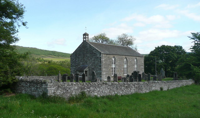
Struan Kirk
Prettily positioned beside the Errochty Water and the River Garry.
276:
226:
154:
144:
313:
325:
925:
Click on a date/time to view the file as it appeared at that time.
278:
228:
253:
203:
61:
263:
56° 45′ 52″ N, 3° 57′ 01″ W
213:
56° 45′ 51″ N, 3° 57′ 03″ W
452:
Add a one-line explanation of what this file represents
105:
85:
Commons is a freely licensed media file repository.
621:
Creative
Commons Attribution-ShareAlike 2.0 Generic
51:(640 × 378 pixels, file size: 64 KB, MIME type:
123:http://www.geocities.com/athollkirks/struan.htm
421:https://creativecommons.org/licenses/by-sa/2.0
66:
427:Creative Commons Attribution-Share Alike 2.0
345:
8:
823:
638:
387:– to copy, distribute and transmit the work
111:Struan Kirk - geograph.org.uk - 1335727.jpg
47:Struan_Kirk_-_geograph.org.uk_-_1335727.jpg
1005:
927:
448:
790:https://www.geograph.org.uk/photo/1335727
548:https://www.geograph.org.uk/profile/23874
1007:
987:
903:
887:
847:
831:
752:
736:
718:
702:
662:
646:
618:
602:
582:
566:
499:
483:
466:
463:
444:
437:
256:
206:
285:View this and other nearby images on:
235:View this and other nearby images on:
7:
332:and is licensed for reuse under the
985:The following page uses this file:
916:
368:Attribution-Share Alike 2.0 Generic
356:
351:
336:Attribution-ShareAlike 2.0 license.
998:
457:
451:
342:
319:
115:
98:
44:
456:
649:coordinates of the point of view
442:
398:Under the following conditions:
363:This file is licensed under the
355:
350:
344:
312:
291:
277:
269:
241:
227:
219:
65:
21:
439:
116:
41:No higher resolution available.
14:
755:file available on the internet
438:
320:This image was taken from the
26:
1:
834:coordinates of depicted place
31:
805:Geograph Britain and Ireland
513:object of statement has role
464:Items portrayed in this file
268:
218:
1029:
849:56°45'52.24"N, 3°57'0.72"W
664:56°45'51.23"N, 3°57'3.24"W
412:same or compatible license
917:
194:Russel Wills /
175:Russel Wills /
16:
768:geograph.org.uk image ID
441:
378:
72:This is a file from the
974:
953:02:27, 28 February 2011
166:required by the license
150:
139:
132:
129:
108:
76:. Information from its
326:this photograph's page
297:56.764510; -3.950200
247:56.764230; -3.950900
79:description page there
393:– to adapt the work
990:Struan, Perthshire
528:author name string
1016:
1015:
978:
825:
640:
605:copyright license
450:
341:
340:
324:collection. See
302:
301:
252:
251:
201:
200:
169:
94:
93:
74:Wikimedia Commons
1020:
1006:
965:
871:
870:
865:
807:
802:
792:
787:
783:described at URL
777:
772:
686:
685:
680:
569:copyright status
550:
545:
535:
532:
522:
517:
434:
431:
428:
425:
422:
414:as the original.
376:
365:Creative Commons
359:
358:
354:
353:
348:
347:
334:Creative Commons
322:Geograph project
316:
309:
298:
295:
281:
280:
274:
273:
272:
266:
265:
254:
248:
245:
231:
230:
224:
223:
222:
216:
215:
204:
163:
135:
120:
112:
106:
90:
69:
68:
62:
56:
54:
1028:
1027:
1023:
1022:
1021:
1019:
1018:
1017:
994:
979:
971:
963:
919:
918:
915:
914:
913:
912:
911:
910:
909:
908:
906:
896:
895:
894:
892:
881:
880:
879:
878:
877:
876:
875:
874:
873:
872:
868:
866:
863:
854:
853:
852:
850:
840:
839:
838:
836:
817:
816:
815:
814:
813:
812:
811:
810:
809:
808:
803:
800:
794:
793:
788:
785:
779:
778:
773:
770:
761:
760:
759:
757:
745:
744:
743:
741:
730:
729:
728:
727:
726:
725:
724:
723:
721:
711:
710:
709:
707:
696:
695:
694:
693:
692:
691:
690:
689:
688:
687:
683:
681:
678:
669:
668:
667:
665:
655:
654:
653:
651:
632:
631:
630:
629:
628:
627:
626:
625:
623:
611:
610:
609:
607:
596:
595:
594:
593:
592:
591:
590:
589:
587:
575:
574:
573:
571:
560:
559:
558:
557:
556:
555:
554:
553:
552:
551:
546:
543:
537:
536:
533:
530:
524:
523:
518:
515:
506:
505:
504:
502:
492:
491:
490:
488:
477:
476:
475:
474:
473:
471:
455:
454:
453:
436:
435:
432:
429:
426:
423:
420:
419:
377:
374:
371:
360:
337:
307:
296:
270:
261:
260:
257:Object location
246:
220:
211:
210:
207:Camera location
202:
191:
184:
172:
145:geograph.org.uk
125:
110:
103:
96:
95:
84:
83:
82:is shown below.
58:
52:
50:
43:
42:
12:
11:
5:
1026:
1024:
1014:
1013:
1010:
997:
993:
992:
983:
982:
977:
976:
973:
969:
966:
960:
955:
950:
946:
945:
942:
939:
936:
933:
930:
923:
922:
907:
904:
902:
901:
900:
899:
898:
897:
893:
888:
886:
885:
884:
883:
882:
859:
858:
857:
856:
855:
851:
848:
846:
845:
844:
843:
842:
841:
837:
832:
830:
829:
828:
827:
821:
796:
795:
781:
780:
766:
765:
764:
763:
762:
758:
753:
751:
750:
749:
748:
747:
746:
742:
739:source of file
737:
735:
734:
733:
732:
731:
722:
719:
717:
716:
715:
714:
713:
712:
708:
703:
701:
700:
699:
698:
697:
674:
673:
672:
671:
670:
666:
663:
661:
660:
659:
658:
657:
656:
652:
647:
645:
644:
643:
642:
636:
624:
619:
617:
616:
615:
614:
613:
612:
608:
603:
601:
600:
599:
598:
597:
588:
583:
581:
580:
579:
578:
577:
576:
572:
567:
565:
564:
563:
562:
561:
539:
538:
526:
525:
511:
510:
509:
508:
507:
503:
500:
498:
497:
496:
495:
494:
493:
489:
484:
482:
481:
480:
479:
478:
472:
467:
465:
462:
461:
460:
459:
458:
447:
446:
443:
440:
418:
417:
416:
415:
405:
396:
395:
394:
388:
381:You are free:
372:
362:
361:
343:
339:
338:
317:
306:
303:
300:
299:
289:
283:
258:
250:
249:
239:
233:
208:
199:
198:
192:
189:
186:
185:
180:
173:
170:
158:
157:
152:
148:
147:
141:
137:
136:
131:
127:
126:
113:
104:
102:
99:
97:
92:
91:
70:
60:
59:
40:
36:
35:
34:
29:
24:
19:
13:
10:
9:
6:
4:
3:
2:
1025:
1011:
1008:
1004:
1001:
995:
991:
988:
986:
980:
972:
967:
961:
959:
956:
954:
951:
948:
947:
943:
940:
937:
934:
931:
929:
928:
926:
920:
891:
862:
835:
806:
799:
791:
784:
776:
769:
756:
740:
706:
677:
650:
622:
606:
586:
570:
549:
542:
529:
521:
514:
487:
470:
424:CC BY-SA 2.0
413:
409:
406:
403:
400:
399:
397:
392:
389:
386:
383:
382:
380:
379:
373:Attribution:
369:
366:
349:
335:
331:
327:
323:
318:
315:
311:
310:
304:
294:
290:
288:
287:OpenStreetMap
284:
282:
264:
259:
255:
244:
240:
238:
237:OpenStreetMap
234:
232:
214:
209:
205:
197:
193:
188:
187:
183:
179: /
178:
174:
167:
162:
160:
159:
156:
153:
149:
146:
142:
138:
128:
124:
119:
114:
107:
100:
88:
81:
80:
75:
71:
64:
63:
57:
48:
39:
33:
30:
28:
25:
23:
20:
18:
15:
1002:
999:
984:
924:
921:File history
534:Russel Wills
520:photographer
407:
401:
390:
384:
375:Russel Wills
330:Russel Wills
329:
267:
217:
195:
182:CC BY-SA 2.0
176:
155:Russel Wills
117:
87:You can help
77:
45:
22:File history
970:GeographBot
720:3 June 2009
585:copyrighted
408:share alike
402:attribution
196:Struan Kirk
177:Struan Kirk
161:Attribution
134:3 June 2009
109:Description
1009:_error
981:File usage
962:640 × 378
938:Dimensions
905:image/jpeg
890:media type
501:some value
53:image/jpeg
27:File usage
935:Thumbnail
932:Date/Time
705:inception
305:Licensing
190:InfoField
171:InfoField
118:English:
996:Metadata
798:operator
445:Captions
391:to remix
385:to share
370:license.
32:Metadata
964:(64 KB)
949:current
944:Comment
861:heading
820:heading
775:1335727
676:heading
635:heading
486:creator
469:depicts
449:English
101:Summary
49:
869:degree
824:degree
684:degree
639:degree
275:
225:
151:Author
140:Source
143:From
941:User
433:true
430:true
130:Date
17:File
867:45
682:45
541:URL
864::
801::
786::
771::
679::
544::
531::
516::
1012:0
168:)
164:(
89:.
55:)
Text is available under the Creative Commons Attribution-ShareAlike License. Additional terms may apply.
_heading:45.00&language=en)
_heading:45.00&language=en)
