348:
281:
231:
273:
223:
295:
245:
316:
354:
359:
72:
860:"}},"text\/plain":{"en":{"":"heading"}}},"{\"value\":{\"amount\":\"+270\",\"unit\":\"http:\\\/\\\/www.wikidata.org\\\/entity\\\/Q28390\"},\"type\":\"quantity\"}":{"text\/html":{"en":{"P7787":"270
760:"}},"text\/plain":{"en":{"":"heading"}}},"{\"value\":{\"amount\":\"+270\",\"unit\":\"http:\\\/\\\/www.wikidata.org\\\/entity\\\/Q28390\"},\"type\":\"quantity\"}":{"text\/html":{"en":{"P7787":"270
856:
264:
979:== {{int:filedesc}} == {{Information |description={{en|1=Sutton Church St Andrew's church is one of the largest in the Fens. It has an unusual octagonal lantern tower, topped wedding cake-style by a second octagonal tower and a small spire.}} |date=2007-0
214:
43:
406:– You must give appropriate credit, provide a link to the license, and indicate if changes were made. You may do so in any reasonable manner, but not in any way that suggests the licensor endorses you or your use.
126:
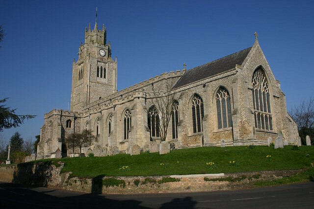
Sutton Church St Andrew's church is one of the largest in the Fens. It has an unusual octagonal lantern tower, topped wedding cake-style by a second octagonal tower and a small spire.
857:
757:
83:
51:
993:
658:
622:
586:
288:
238:
693:
1178:
323:
1059:
This file contains additional information, probably added from the digital camera or scanner used to create or digitize it.
413:
843:
549:
898:
871:
827:
798:
771:
701:
642:
570:
542:
529:
514:
729:
686:
671:
606:
487:
470:
310:
961:
956:
369:
42:
1062:
If the file has been modified from its original state, some details may not fully reflect the modified file.
1081:
989:
The following pages on the
English Knowledge (XXG) use this file (pages on other projects are not listed):
1223:
412:– If you remix, transform, or build upon the material, you must distribute your contributions under the
330:
on the
Geograph website for the photographer's contact details. The copyright on this image is owned by
972:
366:
864:"}},"text\/plain":{"en":{"P7787":"270 degree"}}}}": -->
764:"}},"text\/plain":{"en":{"P7787":"270 degree"}}}}": -->
1251:
91:
183:
708:
678:
167:
1071:
521:
1016:
294:
244:
1319:
1241:
1205:
1088:
998:
335:
78:
1128:
1261:
135:
1108:
278:
228:
146:
156:
1098:
315:
327:
929:
Click on a date/time to view the file as it appeared at that time.
280:
230:
255:
205:
66:
265:
52° 23′ 22″ N, 0° 07′ 37″ E
215:
52° 23′ 22″ N, 0° 07′ 41″ E
454:
Add a one-line explanation of what this file represents
1046:
1026:
1036:
110:
90:
Commons is a freely licensed media file repository.
623:
Creative
Commons Attribution-ShareAlike 2.0 Generic
1256:Flash did not fire, compulsory flash suppression
56:(640 × 427 pixels, file size: 69 KB, MIME type:
423:https://creativecommons.org/licenses/by-sa/2.0
71:
429:Creative Commons Attribution-Share Alike 2.0
347:
8:
116:Sutton Church - geograph.org.uk - 378802.jpg
52:Sutton_Church_-_geograph.org.uk_-_378802.jpg
861:
761:
389:– to copy, distribute and transmit the work
1064:
1017:Grade I listed buildings in Cambridgeshire
994:Grade I listed buildings in Cambridgeshire
931:
450:
1009:The following other wikis use this file:
679:https://www.geograph.org.uk/photo/378802
1327:
1317:
1309:
1301:
1293:
1285:
1277:
1269:
1259:
1249:
1239:
1231:
1221:
1213:
1203:
1195:
1187:
1176:
1168:
1160:
1152:
1144:
1136:
1125:
1117:
1106:
1096:
1086:
1076:
991:
885:
869:
841:
825:
785:
769:
743:
727:
656:
640:
620:
604:
584:
568:
522:https://www.geograph.org.uk/profile/636
501:
485:
468:
465:
446:
439:
258:
208:
287:View this and other nearby images on:
237:View this and other nearby images on:
1066:
7:
334:and is licensed for reuse under the
920:
370:Attribution-Share Alike 2.0 Generic
358:
353:
338:Attribution-ShareAlike 2.0 license.
1057:
459:
453:
344:
321:
120:
103:
49:
458:
1119:Date and time of data generation
772:coordinates of the point of view
444:
400:Under the following conditions:
365:This file is licensed under the
357:
352:
346:
314:
293:
279:
271:
243:
229:
221:
70:
31:
21:
441:
121:
46:No higher resolution available.
14:
659:file available on the internet
440:
322:This image was taken from the
26:
1:
872:coordinates of depicted place
36:
1236:3.6147155761719 APEX (f/3.5)
694:Geograph Britain and Ireland
543:object of statement has role
466:Items portrayed in this file
270:
220:
1287:Focal plane resolution unit
1189:Date and time of digitizing
1013:Usage on dag.wikipedia.org
1349:
1298:One-chip color area sensor
1043:Usage on www.wikidata.org
1033:Usage on eu.wikipedia.org
1023:Usage on es.wikipedia.org
887:52°23'22.42"N, 0°7'36.84"E
787:52°23'22.02"N, 0°7'41.16"E
414:same or compatible license
1162:File change date and time
921:
16:
1279:Focal plane Y resolution
1271:Focal plane X resolution
702:geograph.org.uk image ID
443:
380:
77:This is a file from the
1303:Custom image processing
978:
168:required by the license
152:
141:
134:
131:
113:
81:. Information from its
1197:Image compression mode
1082:Canon EOS 300D DIGITAL
328:this photograph's page
299:52.389560; 0.126900
249:52.389450; 0.128100
196:Bob Jones /
177:Bob Jones /
84:description page there
1233:Maximum land aperture
1146:Horizontal resolution
957:21:35, 4 January 2011
1192:10:03, 26 March 2007
1165:10:03, 26 March 2007
1122:10:03, 26 March 2007
1170:Y and C positioning
1154:Vertical resolution
1093:1/160 sec (0.00625)
1068:Camera manufacturer
395:– to adapt the work
1329:Scene capture type
1324:Auto white balance
530:author name string
1336:
1335:
1005:Global file usage
982:
863:
763:
607:copyright license
452:
343:
342:
326:collection. See
304:
303:
254:
253:
203:
202:
171:
99:
98:
79:Wikimedia Commons
32:Global file usage
1340:
1282:3,442.0168067227
1274:3,443.9461883408
1065:
969:
909:
908:
903:
809:
808:
803:
711:
706:
696:
691:
681:
676:
672:described at URL
571:copyright status
552:
547:
537:
534:
524:
519:
436:
433:
430:
427:
424:
416:as the original.
378:
367:Creative Commons
361:
360:
356:
355:
350:
349:
336:Creative Commons
324:Geograph project
318:
311:
300:
297:
283:
282:
276:
275:
274:
268:
267:
256:
250:
247:
233:
232:
226:
225:
224:
218:
217:
206:
165:
137:
125:
117:
111:
95:
74:
73:
67:
61:
59:
1348:
1347:
1343:
1342:
1341:
1339:
1338:
1337:
1210:7.3219299316406
1053:
1003:
990:
983:
975:
967:
923:
922:
919:
918:
917:
916:
915:
914:
913:
912:
911:
910:
906:
904:
901:
892:
891:
890:
888:
878:
877:
876:
874:
855:
854:
853:
852:
851:
850:
849:
848:
846:
834:
833:
832:
830:
819:
818:
817:
816:
815:
814:
813:
812:
811:
810:
806:
804:
801:
792:
791:
790:
788:
778:
777:
776:
774:
755:
754:
753:
752:
751:
750:
749:
748:
746:
736:
735:
734:
732:
721:
720:
719:
718:
717:
716:
715:
714:
713:
712:
707:
704:
698:
697:
692:
689:
683:
682:
677:
674:
665:
664:
663:
661:
649:
648:
647:
645:
634:
633:
632:
631:
630:
629:
628:
627:
625:
613:
612:
611:
609:
598:
597:
596:
595:
594:
593:
592:
591:
589:
577:
576:
575:
573:
562:
561:
560:
559:
558:
557:
556:
555:
554:
553:
548:
545:
539:
538:
535:
532:
526:
525:
520:
517:
508:
507:
506:
504:
494:
493:
492:
490:
479:
478:
477:
476:
475:
473:
457:
456:
455:
438:
437:
434:
431:
428:
425:
422:
421:
379:
376:
373:
362:
339:
309:
298:
272:
263:
262:
259:Object location
248:
222:
213:
212:
209:Camera location
204:
193:
186:
174:
147:geograph.org.uk
127:
115:
108:
101:
100:
89:
88:
87:is shown below.
63:
57:
55:
48:
47:
12:
11:
5:
1346:
1344:
1334:
1333:
1330:
1326:
1325:
1322:
1316:
1315:
1312:
1308:
1307:
1306:Normal process
1304:
1300:
1299:
1296:
1295:Sensing method
1292:
1291:
1288:
1284:
1283:
1280:
1276:
1275:
1272:
1268:
1267:
1264:
1258:
1257:
1254:
1248:
1247:
1244:
1238:
1237:
1234:
1230:
1229:
1226:
1220:
1219:
1216:
1212:
1211:
1208:
1202:
1201:
1198:
1194:
1193:
1190:
1186:
1185:
1182:
1175:
1174:
1171:
1167:
1166:
1163:
1159:
1158:
1155:
1151:
1150:
1147:
1143:
1142:
1139:
1135:
1134:
1131:
1124:
1123:
1120:
1116:
1115:
1112:
1105:
1104:
1101:
1095:
1094:
1091:
1085:
1084:
1079:
1075:
1074:
1069:
1056:
1052:
1051:
1050:
1049:
1041:
1040:
1039:
1031:
1030:
1029:
1021:
1020:
1019:
1007:
1006:
1002:
1001:
996:
988:
987:
986:
981:
980:
977:
973:
970:
964:
959:
954:
950:
949:
946:
943:
940:
937:
934:
927:
926:
897:
896:
895:
894:
893:
889:
886:
884:
883:
882:
881:
880:
879:
875:
870:
868:
867:
866:
865:
859:
847:
844:Canon EOS 300D
842:
840:
839:
838:
837:
836:
835:
831:
826:
824:
823:
822:
821:
820:
797:
796:
795:
794:
793:
789:
786:
784:
783:
782:
781:
780:
779:
775:
770:
768:
767:
766:
765:
759:
747:
744:
742:
741:
740:
739:
738:
737:
733:
728:
726:
725:
724:
723:
722:
700:
699:
685:
684:
670:
669:
668:
667:
666:
662:
657:
655:
654:
653:
652:
651:
650:
646:
643:source of file
641:
639:
638:
637:
636:
635:
626:
621:
619:
618:
617:
616:
615:
614:
610:
605:
603:
602:
601:
600:
599:
590:
585:
583:
582:
581:
580:
579:
578:
574:
569:
567:
566:
565:
564:
563:
541:
540:
528:
527:
513:
512:
511:
510:
509:
505:
502:
500:
499:
498:
497:
496:
495:
491:
486:
484:
483:
482:
481:
480:
474:
469:
467:
464:
463:
462:
461:
460:
449:
448:
445:
442:
420:
419:
418:
417:
407:
398:
397:
396:
390:
383:You are free:
374:
364:
363:
345:
341:
340:
319:
308:
305:
302:
301:
291:
285:
260:
252:
251:
241:
235:
210:
201:
200:
194:
191:
188:
187:
182:
175:
172:
160:
159:
154:
150:
149:
143:
139:
138:
133:
129:
128:
118:
109:
107:
104:
102:
97:
96:
75:
65:
64:
45:
41:
40:
39:
34:
29:
24:
19:
13:
10:
9:
6:
4:
3:
2:
1345:
1331:
1328:
1323:
1321:
1320:White balance
1318:
1314:Auto exposure
1313:
1311:Exposure mode
1310:
1305:
1302:
1297:
1294:
1289:
1286:
1281:
1278:
1273:
1270:
1265:
1263:
1260:
1255:
1253:
1250:
1245:
1243:
1242:Metering mode
1240:
1235:
1232:
1227:
1225:
1224:Exposure bias
1222:
1217:
1215:APEX aperture
1214:
1209:
1207:
1206:Shutter speed
1204:
1199:
1196:
1191:
1188:
1183:
1180:
1177:
1172:
1169:
1164:
1161:
1156:
1153:
1148:
1145:
1140:
1137:
1132:
1130:
1126:
1121:
1118:
1113:
1110:
1107:
1102:
1100:
1097:
1092:
1090:
1089:Exposure time
1087:
1083:
1080:
1077:
1073:
1070:
1067:
1063:
1060:
1054:
1048:
1045:
1044:
1042:
1038:
1035:
1034:
1032:
1028:
1025:
1024:
1022:
1018:
1015:
1014:
1012:
1011:
1010:
1004:
1000:
999:Lantern tower
997:
995:
992:
984:
976:
971:
965:
963:
960:
958:
955:
952:
951:
947:
944:
941:
938:
935:
933:
932:
930:
924:
900:
873:
845:
829:
828:captured with
800:
773:
745:26 March 2007
731:
710:
703:
695:
688:
680:
673:
660:
644:
624:
608:
588:
572:
551:
544:
531:
523:
516:
489:
472:
426:CC BY-SA 2.0
415:
411:
408:
405:
402:
401:
399:
394:
391:
388:
385:
384:
382:
381:
375:Attribution:
371:
368:
351:
337:
333:
329:
325:
320:
317:
313:
312:
306:
296:
292:
290:
289:OpenStreetMap
286:
284:
266:
261:
257:
246:
242:
240:
239:OpenStreetMap
236:
234:
216:
211:
207:
199:
198:Sutton Church
195:
190:
189:
185:
181: /
180:
179:Sutton Church
176:
169:
164:
162:
161:
158:
155:
151:
148:
144:
140:
136:26 March 2007
130:
124:
119:
112:
105:
93:
86:
85:
80:
76:
69:
68:
62:
53:
44:
38:
35:
33:
30:
28:
25:
23:
20:
18:
15:
1129:focal length
1078:Camera model
1061:
1058:
1008:
928:
925:File history
550:photographer
409:
403:
392:
386:
331:
269:
219:
197:
184:CC BY-SA 2.0
178:
122:
92:You can help
82:
50:
22:File history
1262:Color space
1138:Orientation
974:GeographBot
587:copyrighted
410:share alike
404:attribution
163:Attribution
114:Description
985:File usage
966:640 × 427
942:Dimensions
503:some value
58:image/jpeg
27:File usage
1109:ISO speed
1047:Q17527704
1027:Cimborrio
939:Thumbnail
936:Date/Time
730:inception
536:Bob Jones
377:Bob Jones
332:Bob Jones
307:Licensing
192:InfoField
173:InfoField
157:Bob Jones
123:English:
1332:Standard
1173:Co-sited
1099:F-number
1055:Metadata
1037:Zinborio
687:operator
447:Captions
393:to remix
387:to share
372:license.
37:Metadata
1246:Pattern
1181:version
1157:180 dpi
1149:180 dpi
968:(69 KB)
953:current
948:Comment
899:heading
858:heading
799:heading
758:heading
488:creator
471:depicts
451:English
106:Summary
54:
1290:inches
1141:Normal
1111:rating
907:degree
862:degree
807:degree
762:degree
709:378802
277:
227:
153:Author
142:Source
1252:Flash
1133:22 mm
1127:Lens
1072:Canon
145:From
1266:sRGB
1184:2.21
1179:Exif
945:User
905:270
805:270
435:true
432:true
132:Date
17:File
1114:100
1103:f/8
515:URL
902::
802::
705::
690::
675::
546::
533::
518::
1228:0
1218:6
1200:3
170:)
166:(
94:.
60:)
Text is available under the Creative Commons Attribution-ShareAlike License. Additional terms may apply.
_heading:270.00&language=en)
_heading:270.00&language=en)
