180:
186:
191:
67:
455:
38:
232:– You must give appropriate credit, provide a link to the license, and indicate if changes were made. You may do so in any reasonable manner, but not in any way that suggests the licensor endorses you or your use.
503:
513:
78:
46:
366:
330:
524:
This file contains additional information, probably added from the digital camera or scanner used to create or digitize it.
239:
314:
386:
350:
297:
508:
201:
454:
449:
37:
527:
If the file has been modified from its original state, some details may not fully reflect the modified file.
494:
The following pages on the
English Knowledge (XXG) use this file (pages on other projects are not listed):
238:– If you remix, transform, or build upon the material, you must distribute your contributions under the
198:
498:
116:
86:
473:
539:
120:
73:
173:
I, the copyright holder of this work, hereby publish it under the following license:
477:
465:
147:
No machine-readable source provided. Own work assumed (based on copyright claims).
156:
128:
422:
Click on a date/time to view the file as it appeared at that time.
124:
481:
61:
281:
Add a one-line explanation of what this file represents
105:
85:
Commons is a freely licensed media file repository.
504:
367:
Creative
Commons Attribution-ShareAlike 2.5 Generic
51:(500 × 500 pixels, file size: 139 KB, MIME type:
514:Template talk:Susquehanna River System/Archive1
249:https://creativecommons.org/licenses/by-sa/2.5
66:
484:data using as a reference. {{self|cc-by-sa-
255:Creative Commons Attribution-Share Alike 2.5
179:
8:
215:– to copy, distribute and transmit the work
111:Sub-watersheds of the Susquehanna River.png
47:Sub-watersheds_of_the_Susquehanna_River.png
529:
424:
277:
536:
531:
496:
400:
384:
364:
348:
328:
312:
295:
292:
273:
266:
155:No machine-readable author provided.
7:
159:assumed (based on copyright claims).
413:
202:Attribution-Share Alike 2.5 Generic
190:
185:
522:
286:
280:
176:
172:
139:24 May 2007 (original upload date)
98:
44:
285:
271:
226:Under the following conditions:
197:This file is licensed under the
189:
184:
178:
65:
21:
268:
41:No higher resolution available.
14:
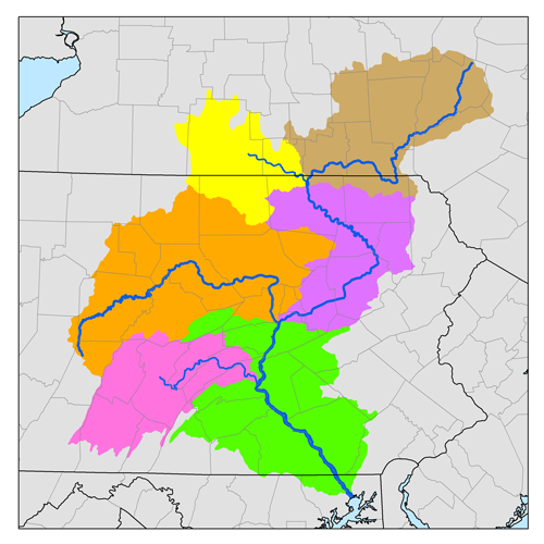
267:
26:
1:
31:
293:Items portrayed in this file
561:
509:List of rivers of Maryland
476:watershed sub-basins. I,
240:same or compatible license
119:watershed sub-basins. I,
414:
16:
270:
206:
72:This is a file from the
471:
151:
143:
138:
135:
108:
76:. Information from its
480:, created it based on
123:, created it based on
79:description page there
472:This is a map of the
115:This is a map of the
221:– to adapt the work
499:Digital line graph
450:14:04, 24 May 2007
548:
547:
487:
474:Susquehanna River
351:copyright license
279:
163:
162:
117:Susquehanna River
94:
93:
74:Wikimedia Commons
552:
542:
540:Adobe ImageReady
530:
462:
315:copyright status
262:
259:
256:
253:
250:
242:as the original.
199:Creative Commons
193:
192:
188:
187:
182:
181:
112:
106:
90:
69:
68:
62:
56:
54:
560:
559:
555:
554:
553:
551:
550:
549:
538:
518:
495:
488:
468:
460:
416:
415:
412:
411:
410:
409:
408:
407:
406:
405:
403:
393:
392:
391:
389:
378:
377:
376:
375:
374:
373:
372:
371:
369:
357:
356:
355:
353:
342:
341:
340:
339:
338:
337:
336:
335:
333:
321:
320:
319:
317:
306:
305:
304:
303:
302:
300:
284:
283:
282:
265:
264:
263:
260:
257:
254:
251:
248:
247:
205:
194:
175:
174:
169:
164:
131:as a reference.
110:
103:
96:
95:
84:
83:
82:is shown below.
58:
52:
50:
43:
42:
12:
11:
5:
558:
556:
546:
545:
544:
543:
534:
521:
517:
516:
511:
506:
501:
493:
492:
491:
486:
485:
470:
466:
463:
457:
452:
447:
443:
442:
439:
436:
433:
430:
427:
420:
419:
404:
401:
399:
398:
397:
396:
395:
394:
390:
385:
383:
382:
381:
380:
379:
370:
365:
363:
362:
361:
360:
359:
358:
354:
349:
347:
346:
345:
344:
343:
334:
329:
327:
326:
325:
324:
323:
322:
318:
313:
311:
310:
309:
308:
307:
301:
296:
294:
291:
290:
289:
288:
287:
276:
275:
272:
269:
246:
245:
244:
243:
233:
224:
223:
222:
216:
209:You are free:
196:
195:
177:
171:
170:
168:
165:
161:
160:
153:
149:
148:
145:
141:
140:
137:
133:
132:
113:
104:
102:
99:
97:
92:
91:
70:
60:
59:
40:
36:
35:
34:
29:
24:
19:
13:
10:
9:
6:
4:
3:
2:
557:
541:
537:
535:
533:Software used
532:
528:
525:
519:
515:
512:
510:
507:
505:
502:
500:
497:
489:
483:
479:
475:
469:
464:
458:
456:
453:
451:
448:
445:
444:
440:
437:
434:
431:
428:
426:
425:
423:
417:
388:
368:
352:
332:
316:
299:
252:CC BY-SA 2.5
241:
237:
234:
231:
228:
227:
225:
220:
217:
214:
211:
210:
208:
207:
203:
200:
183:
166:
158:
154:
150:
146:
142:
134:
130:
126:
122:
118:
114:
107:
100:
88:
81:
80:
75:
71:
64:
63:
57:
48:
39:
33:
30:
28:
25:
23:
20:
18:
15:
526:
523:
421:
418:File history
235:
229:
218:
212:
87:You can help
77:
45:
22:File history
478:Karl Musser
402:24 May 2007
331:copyrighted
236:share alike
230:attribution
127:data using
121:Karl Musser
109:Description
490:File usage
459:500 × 500
435:Dimensions
27:File usage
432:Thumbnail
429:Date/Time
387:inception
167:Licensing
53:image/png
520:Metadata
461:(139 KB)
274:Captions
219:to remix
213:to share
204:license.
32:Metadata
467:Kmusser
446:current
441:Comment
298:depicts
278:English
157:Kmusser
101:Summary
49:
152:Author
144:Source
482:USGS
438:User
261:true
258:true
136:Date
129:SRBC
125:USGS
17:File
89:.
55:)
Text is available under the Creative Commons Attribution-ShareAlike License. Additional terms may apply.