347:
280:
155:
sea at
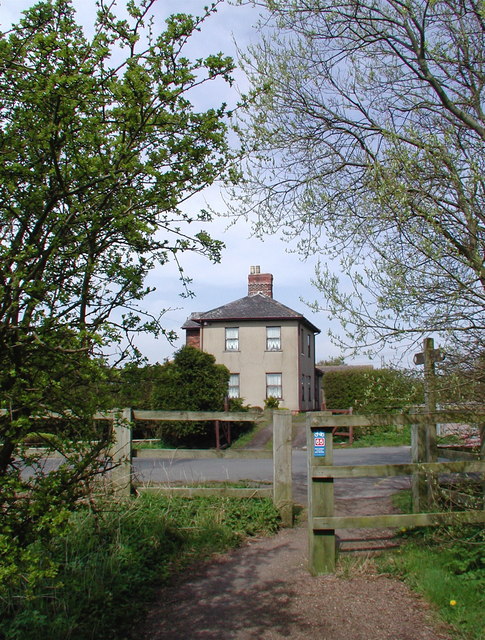
Hornsea and another at Hornsea Bridge at the junction of Southgate and Rolston Road. After little or no financial success the company merged with North Eastern Railway in 1866. As part of sweeping national rail closures, Swine and nearby Ellerby stations closed to goods in 1963 and entirely in 1964 together with the terminus at Hornsea seafront, and Hornsea Bridge Station closed along with the railway line the following year.
272:
294:
315:
353:
358:
87:
759:"}},"text\/plain":{"en":{"":"heading"}}},"{\"value\":{\"amount\":\"+0\",\"unit\":\"http:\\\/\\\/www.wikidata.org\\\/entity\\\/Q28390\"},\"type\":\"quantity\"}":{"text\/html":{"en":{"P7787":"0
755:
154:
In 1846 the York & North
Midland Railway Co. was granted permission to build a line from Beverley to Hornsea, and in 1861 Joseph Armytage Wade promoted the building of a line from Hornsea to Hull and the Hull & Hornsea Railway Co. was formed. The line opened in 1864 with a station near the
158:
The path of the railway now forms the
Hornsea Rail Trail and the eastern stretch of the Trans Pennine Trail. The Trans Pennine Trail runs for 215 miles from Hornsea to Southport and was officially opened in September 2001. Many of the former station buildings like the one here at Swine are now
895:
405:– You must give appropriate credit, provide a link to the license, and indicate if changes were made. You may do so in any reasonable manner, but not in any way that suggests the licensor endorses you or your use.
263:
756:
200:
142:
53:
47:
657:
621:
585:
287:
913:
98:
707:
322:
66:
970:
This file contains additional information, probably added from the digital camera or scanner used to create or digitize it.
412:
520:
826:
797:
770:
685:
641:
569:
541:
528:
513:
152:
Former railway station on the dismantled Hull & Hornsea
Railway line at Swine, looking north across Coniston Lane.
728:
700:
670:
605:
486:
469:
309:
146:
934:
917:
368:
973:
If the file has been modified from its original state, some details may not fully reflect the modified file.
939:
411:– If you remix, transform, or build upon the material, you must distribute your contributions under the
329:
on the
Geograph website for the photographer's contact details. The copyright on this image is owned by
365:
763:"}},"text\/plain":{"en":{"P7787":"0 degree"}}}}": -->
106:
232:
894:
889:
692:
677:
548:
216:
57:
42:
920:
Former railway station on the dismantled Hull & Hornsea
Railway line at Swine, lookin
293:
334:
93:
905:
277:
168:
189:
179:
314:
326:
862:
Click on a date/time to view the file as it appeared at that time.
912:== Summary == {{Information |Description=Swine Railway Station,
279:
264:
53° 48′ 15.22″ N, 0° 15′ 54.93″ W
254:
81:
453:
Add a one-line explanation of what this file represents
957:
207:
Creative
Commons Attribution Share-alike license 2.0
125:
105:
Commons is a freely licensed media file repository.
622:
Creative
Commons Attribution-ShareAlike 2.0 Generic
71:(485 × 640 pixels, file size: 152 KB, MIME type:
422:https://creativecommons.org/licenses/by-sa/2.0
86:
428:Creative Commons Attribution-Share Alike 2.0
346:
8:
760:
388:– to copy, distribute and transmit the work
975:
864:
449:
950:The following other wikis use this file:
678:https://www.geograph.org.uk/photo/774311
549:https://www.geograph.org.uk/profile/6470
977:
932:
840:
824:
784:
768:
742:
726:
655:
639:
619:
603:
583:
567:
500:
484:
467:
464:
445:
438:
257:
286:View this and other nearby images on:
930:The following 2 pages use this file:
7:
333:and is licensed for reuse under the
853:
369:Attribution-Share Alike 2.0 Generic
357:
352:
337:Attribution-ShareAlike 2.0 license.
968:
458:
452:
343:
320:
135:
118:
64:
457:
771:coordinates of the point of view
443:
399:Under the following conditions:
364:This file is licensed under the
356:
351:
345:
313:
292:
278:
270:
85:
31:
21:
440:
136:
14:
658:file available on the internet
439:
321:This image was taken from the
26:
1:
786:53°48'15.221"N, 0°15'54.932"W
36:
708:Geograph Britain and Ireland
514:object of statement has role
465:Items portrayed in this file
999:
954:Usage on www.wikidata.org
413:same or compatible license
269:
245:Paul Glazzard /
226:Paul Glazzard /
854:
131:Swine railway station.jpg
16:
935:Hull and Hornsea Railway
918:East Riding of Yorkshire
686:geograph.org.uk image ID
442:
379:
147:East Riding of Yorkshire
92:This is a file from the
911:
890:17:40, 15 December 2009
217:required by the license
195:
185:
174:
167:
164:
159:privately owned houses.
141:Swine Railway Station,
128:
96:. Information from its
327:this photograph's page
298:53.804228; -0.265259
99:description page there
46:Size of this preview:
940:Swine railway station
394:– to adapt the work
52:Other resolutions:
529:author name string
986:
985:
946:Global file usage
923:
762:
606:copyright license
451:
342:
341:
325:collection. See
303:
302:
252:
251:
220:
204:
201:Reusing this file
114:
113:
94:Wikimedia Commons
32:Global file usage
990:
976:
902:
808:
807:
802:
710:
705:
695:
690:
680:
675:
671:described at URL
570:copyright status
551:
546:
536:
533:
523:
518:
435:
432:
429:
426:
423:
415:as the original.
377:
366:Creative Commons
360:
359:
355:
354:
349:
348:
335:Creative Commons
323:Geograph project
317:
310:
299:
296:
282:
281:
275:
274:
273:
267:
266:
255:
214:
198:
170:
140:
132:
126:
110:
89:
88:
82:
76:
74:
61:
58:485 × 640 pixels
54:182 × 240 pixels
48:454 × 599 pixels
998:
997:
993:
992:
991:
989:
988:
987:
964:
944:
924:
908:
900:
856:
855:
852:
851:
850:
849:
848:
847:
846:
845:
843:
833:
832:
831:
829:
818:
817:
816:
815:
814:
813:
812:
811:
810:
809:
805:
803:
800:
791:
790:
789:
787:
777:
776:
775:
773:
754:
753:
752:
751:
750:
749:
748:
747:
745:
735:
734:
733:
731:
720:
719:
718:
717:
716:
715:
714:
713:
712:
711:
706:
703:
697:
696:
691:
688:
682:
681:
676:
673:
664:
663:
662:
660:
648:
647:
646:
644:
633:
632:
631:
630:
629:
628:
627:
626:
624:
612:
611:
610:
608:
597:
596:
595:
594:
593:
592:
591:
590:
588:
576:
575:
574:
572:
561:
560:
559:
558:
557:
556:
555:
554:
553:
552:
547:
544:
538:
537:
534:
531:
525:
524:
519:
516:
507:
506:
505:
503:
493:
492:
491:
489:
478:
477:
476:
475:
474:
472:
456:
455:
454:
437:
436:
433:
430:
427:
424:
421:
420:
378:
375:
372:
361:
338:
308:
297:
271:
262:
261:
258:Camera location
253:
242:
235:
223:
180:geograph.org.uk
160:
130:
123:
116:
115:
104:
103:
102:is shown below.
78:
72:
70:
63:
62:
51:
12:
11:
5:
996:
994:
984:
983:
980:
967:
963:
962:
961:
960:
948:
947:
943:
942:
937:
928:
927:
922:
921:
910:
906:
903:
897:
892:
887:
883:
882:
879:
876:
873:
870:
867:
860:
859:
844:
841:
839:
838:
837:
836:
835:
834:
830:
825:
823:
822:
821:
820:
819:
796:
795:
794:
793:
792:
788:
785:
783:
782:
781:
780:
779:
778:
774:
769:
767:
766:
765:
764:
758:
746:
743:
741:
740:
739:
738:
737:
736:
732:
727:
725:
724:
723:
722:
721:
699:
698:
684:
683:
669:
668:
667:
666:
665:
661:
656:
654:
653:
652:
651:
650:
649:
645:
642:source of file
640:
638:
637:
636:
635:
634:
625:
620:
618:
617:
616:
615:
614:
613:
609:
604:
602:
601:
600:
599:
598:
589:
584:
582:
581:
580:
579:
578:
577:
573:
568:
566:
565:
564:
563:
562:
540:
539:
527:
526:
512:
511:
510:
509:
508:
504:
501:
499:
498:
497:
496:
495:
494:
490:
485:
483:
482:
481:
480:
479:
473:
468:
466:
463:
462:
461:
460:
459:
448:
447:
444:
441:
419:
418:
417:
416:
406:
397:
396:
395:
389:
382:You are free:
373:
363:
362:
344:
340:
339:
318:
307:
304:
301:
300:
290:
284:
259:
250:
249:
243:
240:
237:
236:
231:
224:
221:
209:
208:
205:
193:
192:
187:
183:
182:
176:
172:
171:
166:
162:
161:
133:
124:
122:
119:
117:
112:
111:
90:
80:
79:
45:
41:
40:
39:
34:
29:
24:
19:
13:
10:
9:
6:
4:
3:
2:
995:
981:
978:
974:
971:
965:
959:
956:
955:
953:
952:
951:
945:
941:
938:
936:
933:
931:
925:
919:
915:
909:
904:
898:
896:
893:
891:
888:
885:
884:
880:
877:
874:
871:
868:
866:
865:
863:
857:
828:
799:
772:
744:21 April 2008
730:
709:
702:
694:
687:
679:
672:
659:
643:
623:
607:
587:
571:
550:
543:
535:Paul Glazzard
530:
522:
515:
488:
471:
425:CC BY-SA 2.0
414:
410:
407:
404:
401:
400:
398:
393:
390:
387:
384:
383:
381:
380:
376:Paul Glazzard
374:Attribution:
370:
367:
350:
336:
332:
331:Paul Glazzard
328:
324:
319:
316:
312:
311:
305:
295:
291:
289:
288:OpenStreetMap
285:
283:
265:
260:
256:
248:
247:Swine Station
244:
239:
238:
234:
230: /
229:
228:Swine Station
225:
218:
213:
211:
210:
206:
202:
197:
194:
191:
190:Paul Glazzard
188:
184:
181:
177:
173:
169:21 April 2008
163:
157:
156:
153:
151:
148:
144:
139:
134:
127:
120:
108:
101:
100:
95:
91:
84:
83:
77:
68:
67:Original file
59:
55:
49:
44:
38:
35:
33:
30:
28:
25:
23:
20:
18:
15:
972:
969:
949:
929:
861:
858:File history
521:photographer
408:
402:
391:
385:
330:
268:
246:
233:CC BY-SA 2.0
227:
150:
137:
107:You can help
97:
65:
22:File history
586:copyrighted
409:share alike
403:attribution
212:Attribution
149:, England.
129:Description
979:_error
926:File usage
899:485 × 640
875:Dimensions
842:image/jpeg
827:media type
502:some value
196:Permission
73:image/jpeg
27:File usage
872:Thumbnail
869:Date/Time
729:inception
306:Licensing
241:InfoField
222:InfoField
138:English:
966:Metadata
958:Q7658470
901:(152 KB)
701:operator
446:Captions
392:to remix
386:to share
371:license.
37:Metadata
907:Keith D
886:current
881:Comment
798:heading
757:heading
487:creator
470:depicts
450:English
121:Summary
69:
806:degree
761:degree
693:774311
276:
186:Author
175:Source
914:Swine
178:From
143:Swine
878:User
434:true
431:true
165:Date
17:File
542:URL
916:,
804:0
801::
704::
689::
674::
545::
532::
517::
145:,
56:|
50:.
982:0
219:)
215:(
203:)
199:(
109:.
75:)
60:.
Text is available under the Creative Commons Attribution-ShareAlike License. Additional terms may apply.
