522:
312:
299:
257:
292:
222:
38:
285:
327:
212:
206:
94:
148:
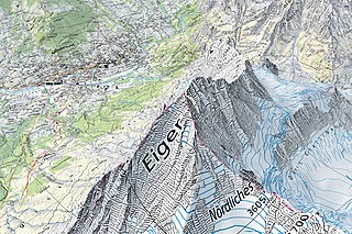
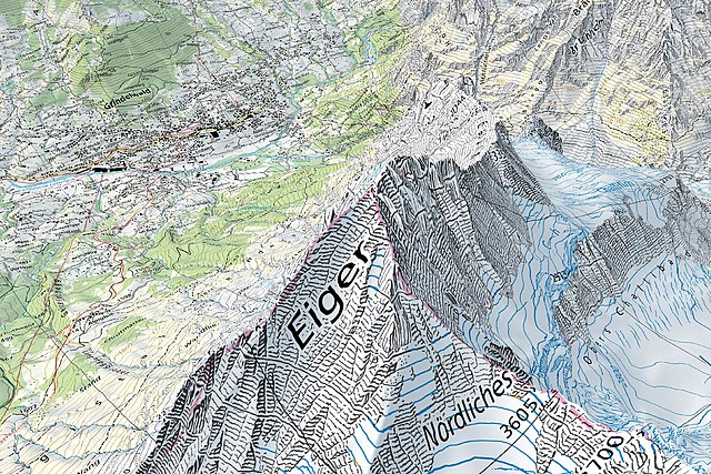
Screen capture taken on the geographical portal map.geo.admin.ch, displaying the 1:25'000 Swiss national map along with terrain elevation (3D rendering). The map (centered on the Eiger) shows various terrain types (settlements, rivers, forests, open areas, rocks and glaciers) and elevations, from
718:
249:
443:
In the case of digital or analogue representations and publications, as well as in the case of dissemination, one of the following source references must be attached in any case:
349:
336:
60:
56:
52:
48:
42:
105:
284:
73:
512:
355:
291:
595:
749:
612:
437:
may be used, distributed and made accessible. Furthermore, they may be enriched and processed and also used commercially.
629:
578:
649:
562:
381:
467:
728:
362:
388:
375:
717:
712:
268:
64:
37:
113:
269:
205:
427:
190:
507:
503:
499:
495:
772:
521:
311:
298:
256:
473:
196:
100:
777:
735:
Uploaded a work by
Bundesamt für Landestopografie swisstopo from with UploadWizard
402:
158:
326:
250:
211:
754:
368:
221:
342:
149:
about 1,000 metres above sea level to about 4,000 metres above sea level.
331:
177:
685:
Click on a date/time to view the file as it appeared at that time.
469:
Terms of use for free geodata and geoservices (OGD) from swisstopo
394:
281:
46° 55′ 40.62″ N, 7° 27′ 04.9″ E
88:
520:
171:
251:
Federal
Department of Defence, Civil Protection and Sports
546:
Add a one-line explanation of what this file represents
797:
787:
78:(1,537 × 1,025 pixels, file size: 783 KB, MIME type:
132:
112:
Commons is a freely licensed media file repository.
475:
Frequently asked questions about free basic geodata
197:
93:
8:
687:
542:
511:
310:
297:
255:
765:The following other wikis use this file:
456:Ufficio federale di topografia swisstopo
450:Bundesamt für Landestopografie swisstopo
773:Système d'information géographique
747:
663:
647:
627:
610:
593:
576:
560:
557:
538:
531:
453:Office fédéral de topographie swisstopo
441:A reference to the source is mandatory.
459:Uffizi federal da topografia swisstopo
447:Federal Office of Topography swisstopo
745:The following 2 pages use this file:
7:
433:The data made publicly available by
676:
551:
545:
142:
125:
71:
550:
138:Swisstopo Eiger - Grindelwald.jpg
536:
325:
290:
283:
220:
210:
204:
92:
31:
21:
533:
238:Ufficio federale di topografia
234:Bundesamt für Landestopografie
143:
14:
532:
236:Office fédéral de topographie
26:
1:
778:Office fédéral de topographie
750:Geographic information system
240:Uffizi federal da topografia
558:Items portrayed in this file
198:Federal Office of Topography
415:institution QS:P195,Q685592
816:
794:Usage on oc.wikipedia.org
784:Usage on ko.wikipedia.org
769:Usage on fr.wikipedia.org
317:
304:
276:
262:
244:
228:
217:
192:
176:3D rendered 1:25'000 map:
677:
321:
308:
280:
266:
248:
232:
218:
193:
16:
535:
99:This is a file from the
734:
185:
164:
157:
154:
135:
103:. Information from its
525:
106:description page there
41:Size of this preview:
524:
485:Attribution-Swisstopo
482:Attribution-Swisstopo
170:Geographical portal:
713:14:30, 29 March 2021
596:3D computer graphics
65:1,537 × 1,025 pixels
47:Other resolutions:
526:
246:Parent institution
61:1,280 × 854 pixels
57:1,024 × 683 pixels
761:Global file usage
738:
544:
530:
529:
515:
420:
419:
412:
411:
121:
120:
101:Wikimedia Commons
32:Global file usage
807:
730:Zacharie Grossen
725:
516:
489:
486:
483:
480:
428:
405:
398:
397:
385:
384:
372:
371:
359:
358:
356:0000000122652235
346:
345:
329:
314:
301:
295:
294:
288:
287:
271:
259:
252:
241:
225:
224:
214:
208:
202:
199:
191:
178:map.geo.admin.ch
172:map.geo.admin.ch
160:
147:
139:
133:
117:
96:
95:
89:
83:
81:
68:
53:640 × 427 pixels
49:320 × 213 pixels
43:800 × 534 pixels
815:
814:
810:
809:
808:
806:
805:
804:
759:
739:
731:
723:
679:
678:
675:
674:
673:
672:
671:
670:
669:
668:
666:
656:
655:
654:
652:
641:
640:
639:
638:
637:
636:
635:
634:
632:
621:
620:
619:
618:
617:
615:
604:
603:
602:
601:
600:
598:
587:
586:
585:
584:
583:
581:
569:
568:
567:
565:
549:
548:
547:
494:
491:
487:
484:
481:
478:
426:
421:
416:
413:
408:
401:
393:
392:
380:
379:
367:
366:
354:
353:
341:
340:
289:
282:
273:
270:Wabern bei Bern
233:
219:
201:
194:
150:
137:
130:
123:
122:
111:
110:
109:is shown below.
85:
79:
77:
70:
69:
46:
12:
11:
5:
813:
811:
803:
802:
801:
800:
792:
791:
790:
782:
781:
780:
775:
763:
762:
758:
757:
752:
743:
742:
737:
736:
733:
729:
726:
722:1,537 × 1,025
720:
715:
710:
706:
705:
702:
699:
696:
693:
690:
683:
682:
667:
664:
662:
661:
660:
659:
658:
657:
653:
648:
646:
645:
644:
643:
642:
633:
628:
626:
625:
624:
623:
622:
616:
611:
609:
608:
607:
606:
605:
599:
594:
592:
591:
590:
589:
588:
582:
577:
575:
574:
573:
572:
571:
570:
566:
561:
559:
556:
555:
554:
553:
552:
541:
540:
537:
534:
528:
527:
518:
464:
463:
460:
457:
454:
451:
448:
431:
425:
422:
418:
417:
414:
410:
409:
407:
406:
399:
386:
373:
360:
347:
334:
322:
320:
319:Authority file
316:
315:
307:
303:
302:
279:
275:
274:
267:
265:
261:
260:
247:
243:
242:
231:
227:
226:
216:
215:
195:
189:
187:
183:
182:
181:
180:
174:
166:
162:
161:
156:
152:
151:
140:
131:
129:
126:
124:
119:
118:
97:
87:
86:
40:
36:
35:
34:
29:
24:
19:
13:
10:
9:
6:
4:
3:
2:
812:
799:
796:
795:
793:
789:
786:
785:
783:
779:
776:
774:
771:
770:
768:
767:
766:
760:
756:
753:
751:
748:
746:
740:
732:
727:
721:
719:
716:
714:
711:
708:
707:
703:
700:
697:
694:
691:
689:
688:
686:
680:
665:29 March 2021
651:
631:
614:
597:
580:
564:
523:
519:
517:
514:
509:
505:
501:
497:
492:
490:
479:{{{tos_url}}}
477:
476:
472:
471:
470:
465:
461:
458:
455:
452:
449:
446:
445:
444:
442:
438:
436:
430:
429:
423:
404:
400:
396:
390:
387:
383:
377:
374:
370:
364:
361:
357:
351:
348:
344:
338:
335:
333:
328:
324:
323:
318:
313:
305:
300:
293:
286:
277:
272:
263:
258:
253:
245:
239:
237:
235:
229:
223:
213:
207:
200:
188:
184:
179:
175:
173:
169:
168:
167:
163:
159:29 March 2021
153:
146:
141:
134:
127:
115:
108:
107:
102:
98:
91:
90:
84:
75:
74:Original file
66:
62:
58:
54:
50:
44:
39:
33:
30:
28:
25:
23:
20:
18:
15:
764:
744:
684:
681:File history
493:
474:
468:
466:
440:
439:
434:
432:
144:
114:You can help
104:
72:
22:File history
613:Grindelwald
306:Established
278:Coordinates
230:Native name
136:Description
741:File usage
698:Dimensions
462:©swisstopo
309:1838
80:image/jpeg
27:File usage
798:Geografia
788:Swisstopo
755:Swisstopo
695:Thumbnail
692:Date/Time
650:inception
435:swisstopo
424:Licensing
395:1084574-4
369:n82157398
343:140124728
145:English:
724:(783 KB)
539:Captions
510: |
506: |
504:italiano
502: |
500:français
498: |
403:WorldCat
382:36398990
264:Location
709:current
704:Comment
563:depicts
543:English
508:English
496:Deutsch
332:Q685592
128:Summary
76:
296:
254:
209:
203:
186:Author
165:Source
630:Eiger
701:User
488:true
363:LCCN
350:ISNI
337:VIAF
155:Date
17:File
579:map
513:+/−
389:GND
376:NLA
391::
378::
365::
352::
339::
330::
63:|
59:|
55:|
51:|
45:.
116:.
82:)
67:.
Text is available under the Creative Commons Attribution-ShareAlike License. Additional terms may apply.

