33:
356:
289:
239:
281:
231:
303:
253:
324:
362:
367:
828:
85:
628:"}},"text\/plain":{"en":{"":"heading"}}},"{\"value\":{\"amount\":\"+135.0\",\"unit\":\"http:\\\/\\\/www.wikidata.org\\\/entity\\\/Q28390\"},\"type\":\"quantity\"}":{"text\/html":{"en":{"P7787":"135.0
564:"}},"text\/plain":{"en":{"":"heading"}}},"{\"value\":{\"amount\":\"+135\",\"unit\":\"http:\\\/\\\/www.wikidata.org\\\/entity\\\/Q28390\"},\"type\":\"quantity\"}":{"text\/html":{"en":{"P7787":"135
798:
624:
222:
51:
47:
43:
37:
64:
96:
414:– You must give appropriate credit, provide a link to the license, and indicate if changes were made. You may do so in any reasonable manner, but not in any way that suggests the licensor endorses you or your use.
625:
561:
827:
822:
797:
792:
55:
32:
547:
511:
296:
246:
331:
421:
729:
666:
639:
602:
575:
495:
845:
Uploaded a work by Des
Blenkinsopp from cc-by-sa/2.0 - © Des Blenkinsopp - geograph.org.uk/p/6454812 with UploadWizard
695:
531:
478:
318:
377:
855:
The following pages on the
English Knowledge (XXG) use this file (pages on other projects are not listed):
139:
Porth
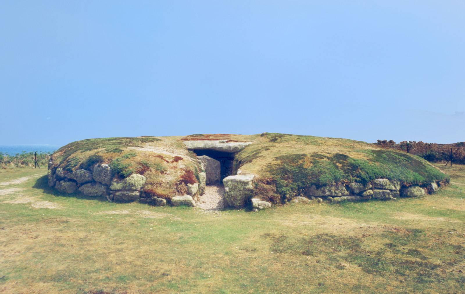
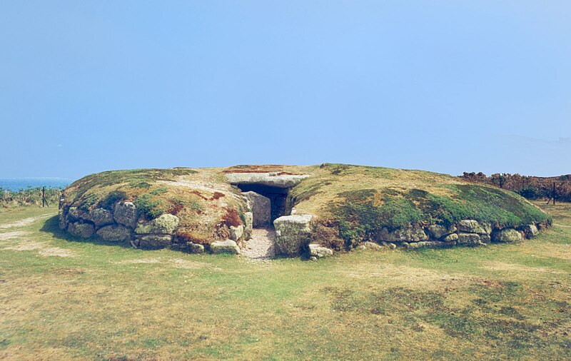
Hellick entrance grave, also known as the Great Tomb, c 2000 BC, St. Mary's Island, Isles of Scilly
420:– If you remix, transform, or build upon the material, you must distribute your contributions under the
338:
on the
Geograph website for the photographer's contact details. The copyright on this image is owned by
632:"}},"text\/plain":{"en":{"P7787":"135.0 degree"}}}}": -->
815:
Un-watermarked version from
Geograph; all information in the watermark is now in the file description
374:
568:"}},"text\/plain":{"en":{"P7787":"135 degree"}}}}": -->
859:
104:
175:
302:
252:
838:
343:
91:
191:
236:
286:
808:
148:
323:
335:
129:
Porth
Hellick Burial Chamber (geograph 6454812 by Des Blenkinsopp).jpg
765:
Click on a date/time to view the file as it appeared at that time.
288:
238:
263:
213:
79:
158:
cc-by-sa/2.0 - © Des
Blenkinsopp - geograph.org.uk/p/6454812
273:
49° 55′ 07.2″ N, 6° 16′ 50″ W
223:
49° 55′ 07.5″ N, 6° 16′ 51″ W
69:(1,600 × 1,013 pixels, file size: 335 KB, MIME type:
123:
103:
Commons is a freely licensed media file repository.
548:
Creative
Commons Attribution-ShareAlike 2.0 Generic
431:https://creativecommons.org/licenses/by-sa/2.0
84:
437:Creative Commons Attribution-Share Alike 2.0
355:
8:
629:
565:
397:– to copy, distribute and transmit the work
767:
458:
857:
743:
727:
709:
693:
653:
637:
589:
573:
545:
529:
509:
493:
476:
473:
454:
447:
266:
216:
295:View this and other nearby images on:
245:View this and other nearby images on:
7:
342:and is licensed for reuse under the
756:
378:Attribution-Share Alike 2.0 Generic
366:
361:
346:Attribution-ShareAlike 2.0 license.
467:
461:
352:
329:
133:
116:
62:
466:
640:coordinates of the point of view
452:
408:Under the following conditions:
373:This file is licensed under the
365:
360:
354:
322:
301:
287:
279:
251:
237:
229:
83:
21:
449:
134:
14:
448:
330:This image was taken from the
26:
1:
576:coordinates of depicted place
655:49°55'7.514"N, 6°16'50.714"W
474:Items portrayed in this file
462:Porth Hellick Entrance grave
278:
228:
206:Porth Hellick Burial Chamber
204:Des Blenkinsopp /
187:Porth Hellick Burial Chamber
185:Des Blenkinsopp /
876:
591:49°55'7.21"N, 6°16'50.20"W
422:same or compatible license
757:
16:
451:
388:
90:This is a file from the
844:
814:
176:required by the license
162:
154:
147:
144:
126:
94:. Information from its
336:this photograph's page
307:49.918670; -6.280610
257:49.918754; -6.280754
97:description page there
36:Size of this preview:
793:17:37, 20 April 2021
56:1,600 × 1,013 pixels
823:23:48, 18 July 2020
403:– to adapt the work
42:Other resolutions:
860:Porth Hellick Down
52:1,024 × 648 pixels
848:
631:
567:
532:copyright license
460:
351:
350:
334:collection. See
312:
311:
262:
261:
211:
210:
179:
112:
111:
92:Wikimedia Commons
867:
835:
805:
677:
676:
671:
613:
612:
607:
496:copyright status
444:
441:
438:
435:
432:
424:as the original.
386:
375:Creative Commons
369:
368:
364:
363:
358:
357:
344:Creative Commons
332:Geograph project
326:
319:
308:
305:
291:
290:
284:
283:
282:
276:
275:
264:
258:
255:
241:
240:
234:
233:
232:
226:
225:
214:
173:
150:
138:
130:
124:
108:
87:
86:
80:
74:
72:
59:
48:640 × 405 pixels
44:320 × 203 pixels
38:800 × 507 pixels
875:
874:
870:
869:
868:
866:
865:
864:
856:
849:
841:
833:
811:
803:
759:
758:
755:
754:
753:
752:
751:
750:
749:
748:
746:
736:
735:
734:
732:
721:
720:
719:
718:
717:
716:
715:
714:
712:
702:
701:
700:
698:
687:
686:
685:
684:
683:
682:
681:
680:
679:
678:
674:
672:
669:
660:
659:
658:
656:
646:
645:
644:
642:
623:
622:
621:
620:
619:
618:
617:
616:
615:
614:
610:
608:
605:
596:
595:
594:
592:
582:
581:
580:
578:
559:
558:
557:
556:
555:
554:
553:
552:
550:
538:
537:
536:
534:
523:
522:
521:
520:
519:
518:
517:
516:
514:
502:
501:
500:
498:
487:
486:
485:
484:
483:
481:
465:
464:
463:
446:
445:
442:
439:
436:
433:
430:
429:
387:
385:Des Blenkinsopp
384:
381:
370:
347:
340:Des Blenkinsopp
317:
306:
280:
271:
270:
267:Object location
256:
230:
221:
220:
217:Camera location
212:
201:
194:
182:
166:Des Blenkinsopp
140:
128:
121:
114:
113:
102:
101:
100:is shown below.
76:
70:
68:
61:
60:
41:
12:
11:
5:
873:
871:
863:
862:
854:
853:
852:
847:
846:
843:
839:
836:
832:1,600 × 1,013
830:
825:
820:
817:
816:
813:
809:
806:
802:1,600 × 1,013
800:
795:
790:
786:
785:
782:
779:
776:
773:
770:
763:
762:
747:
744:
742:
741:
740:
739:
738:
737:
733:
728:
726:
725:
724:
723:
722:
713:
711:September 1997
710:
708:
707:
706:
705:
704:
703:
699:
694:
692:
691:
690:
689:
688:
665:
664:
663:
662:
661:
657:
654:
652:
651:
650:
649:
648:
647:
643:
638:
636:
635:
634:
633:
627:
601:
600:
599:
598:
597:
593:
590:
588:
587:
586:
585:
584:
583:
579:
574:
572:
571:
570:
569:
563:
551:
546:
544:
543:
542:
541:
540:
539:
535:
530:
528:
527:
526:
525:
524:
515:
510:
508:
507:
506:
505:
504:
503:
499:
494:
492:
491:
490:
489:
488:
482:
477:
475:
472:
471:
470:
469:
468:
457:
456:
453:
450:
428:
427:
426:
425:
415:
406:
405:
404:
398:
391:You are free:
382:
372:
371:
353:
349:
348:
327:
316:
313:
310:
309:
299:
293:
268:
260:
259:
249:
243:
218:
209:
208:
202:
199:
196:
195:
190:
183:
180:
168:
167:
164:
160:
159:
156:
152:
151:
149:September 1997
146:
142:
141:
131:
122:
120:
117:
115:
110:
109:
88:
78:
77:
35:
31:
30:
29:
24:
19:
13:
10:
9:
6:
4:
3:
2:
872:
861:
858:
850:
842:
837:
831:
829:
826:
824:
821:
819:
818:
812:
807:
801:
799:
796:
794:
791:
788:
787:
783:
780:
777:
774:
771:
769:
768:
766:
760:
731:
697:
668:
641:
604:
577:
549:
533:
513:
497:
480:
434:CC BY-SA 2.0
423:
419:
416:
413:
410:
409:
407:
402:
399:
396:
393:
392:
390:
389:
383:Attribution:
379:
376:
359:
345:
341:
337:
333:
328:
325:
321:
320:
314:
304:
300:
298:
297:OpenStreetMap
294:
292:
274:
269:
265:
254:
250:
248:
247:OpenStreetMap
244:
242:
224:
219:
215:
207:
203:
198:
197:
193:
189: /
188:
184:
177:
172:
170:
169:
165:
161:
157:
153:
143:
137:
132:
125:
118:
106:
99:
98:
93:
89:
82:
81:
75:
66:
65:Original file
57:
53:
49:
45:
39:
34:
28:
25:
23:
20:
18:
15:
764:
761:File history
417:
411:
400:
394:
339:
277:
227:
205:
192:CC BY-SA 2.0
186:
135:
105:You can help
95:
63:
22:File history
512:copyrighted
418:share alike
412:attribution
171:Attribution
127:Description
851:File usage
778:Dimensions
745:image/jpeg
730:media type
71:image/jpeg
27:File usage
775:Thumbnail
772:Date/Time
696:inception
315:Licensing
200:InfoField
181:InfoField
136:English:
840:MauraWen
834:(345 KB)
804:(335 KB)
455:Captions
401:to remix
395:to share
380:license.
789:current
784:Comment
667:heading
626:heading
603:heading
562:heading
479:depicts
459:English
119:Summary
67:
675:degree
673:135.0
630:degree
611:degree
566:degree
285:
235:
163:Author
155:Source
810:Bjh21
781:User
609:135
443:true
440:true
145:Date
17:File
670::
606::
54:|
50:|
46:|
40:.
178:)
174:(
107:.
73:)
58:.
Text is available under the Creative Commons Attribution-ShareAlike License. Additional terms may apply.
.jpg)
.jpg¶ms=049.918754_N_-006.280754_E_globe:Earth_type:camera_source:geograph-osgb36(SV92831085)_heading:135.00&language=en)
.jpg¶ms=049.918670_N_-006.280610_E_globe:Earth_class:object_type:object_source:geograph-osgb36(SV92841084)_heading:135.00&language=en)
