43:
335:
255:
216:
230:
261:
103:
747:
302:– You must give appropriate credit, provide a link to the license, and indicate if changes were made. You may do so in any reasonable manner, but not in any way that suggests the licensor endorses you or your use.
207:
69:
65:
61:
57:
53:
47:
114:
82:
341:
433:
624:
588:
552:
416:
223:
334:
991:
852:
This file contains additional information, probably added from the digital camera or scanner used to create or digitize it.
399:
678:
608:
536:
508:
495:
480:
644:
572:
453:
383:
746:
741:
487:
73:
42:
855:
If the file has been modified from its original state, some details may not fully reflect the modified file.
777:
The following pages on the
English Knowledge (XXG) use this file (pages on other projects are not listed):
1010:
271:
268:
1072:
757:
781:
122:
765:
515:
344:
229:
1148:
1138:
1054:
869:
804:
109:
248:
I, the copyright holder of this work, hereby publish it under the following license:
1119:
901:
809:
1028:
213:
889:
190:
879:
829:
671:
799:
714:
Click on a date/time to view the file as it appeared at that time.
168:
819:
215:
208:
49° 38′ 27.65″ N, 9° 45′ 00.06″ E
329:
198:
97:
839:
367:
Add a one-line explanation of what this file represents
87:(5,376 × 3,024 pixels, file size: 5.22 MB, MIME type:
141:
121:
Commons is a freely licensed media file repository.
102:
254:
8:
147:Paimar Gedenkplatte Hochwasseropfer 1911.jpg
309:https://creativecommons.org/licenses/by/3.0
285:– to copy, distribute and transmit the work
857:
716:
516:https://commons.wikimedia.org/user:Granpar
363:
792:The following other wikis use this file:
589:Creative Commons Attribution 3.0 Unported
1188:
1180:
1172:
1164:
1156:
1146:
1136:
1128:
1117:
1109:
1088:
1080:
1070:
1062:
1052:
1044:
1036:
1026:
1018:
1008:
1000:
989:
981:
973:
965:
957:
949:
941:
933:
925:
917:
909:
898:
887:
877:
867:
859:
779:
692:
676:
658:
642:
622:
606:
586:
570:
550:
534:
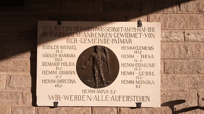
467:
451:
431:
414:
397:
381:
378:
359:
352:
201:
222:View this and other nearby images on:
166:21 September 2020 (according to
7:
810:Benutzer:Triplec85/BW-TBB-Hochwasser
805:Benutzer:Triplec85/BW-TBB-Grünsfeld
705:
260:
167:
850:
372:
366:
276:
251:
247:
151:
134:
80:
874:1/1,655 sec (0.00060422960725076)
371:
315:Creative Commons Attribution 3.0
157:Gedenkplatte Hochwasseropfer 1911
861:Date and time of data generation
694:49°38'27.65069"N, 9°45'0.06170"E
679:coordinates of the point of view
357:
345:Android App (Commons mobile app)
333:
296:Under the following conditions:
267:This file is licensed under the
259:
253:
228:
214:
101:
31:
21:
354:
14:
353:
152:
26:
1:
625:original creation by uploader
36:
1111:DateTimeDigitized subseconds
379:Items portrayed in this file
1130:Date and time of digitizing
1046:DateTimeOriginal subseconds
816:Usage on nds.wikipedia.org
340:This file was uploaded via
1210:
1038:Supported Flashpix version
922:258 meters above sea level
836:Usage on www.wikidata.org
826:Usage on nl.wikipedia.org
796:Usage on de.wikipedia.org
1090:Meaning of each component
983:File change date and time
706:
180:
16:
1133:08:32, 21 September 2020
986:08:32, 21 September 2020
864:08:32, 21 September 2020
742:09:32, 21 September 2020
356:
272:Attribution 3.0 Unported
108:This is a file from the
1174:GPS time (atomic clock)
1153:Center weighted average
830:Gebruiker:Aeroid/Floods
763:
186:
176:
165:
162:
144:
112:. Information from its
800:Benutzer:Aeroid/Floods
234:49.641014; 9.750017
115:description page there
46:Size of this preview:
943:Horizontal resolution
820:Bruker:Aeroid/Floods
400:commemorative plaque
74:5,376 × 3,024 pixels
70:2,560 × 1,440 pixels
1082:DateTime subseconds
967:Y and C positioning
935:Vertical resolution
291:– to adapt the work
52:Other resolutions:
1169:Other light source
1158:Scene capture type
1077:Flash did not fire
1059:Auto white balance
782:User:Aeroid/Floods
766:Commons Mobile App
496:author name string
481:Wikimedia username
347:2.12.3~dc08a5e88.
66:1,280 × 720 pixels
62:1,024 × 576 pixels
1197:
1196:
1185:21 September 2020
788:Global file usage
770:
660:21 September 2020
573:copyright license
365:
351:
350:
239:
238:
196:
195:
130:
129:
110:Wikimedia Commons
32:Global file usage
1201:
1020:Exposure Program
914:49° 38′ 27.65″ N
858:
754:
537:copyright status
518:
513:
503:
500:
490:
485:
337:
330:
322:
319:
316:
313:
310:
269:Creative Commons
263:
262:
257:
256:
235:
232:
218:
217:
211:
210:
199:
182:
171:
156:
148:
142:
126:
105:
104:
98:
92:
90:
77:
58:640 × 360 pixels
54:320 × 180 pixels
48:800 × 450 pixels
1209:
1208:
1204:
1203:
1202:
1200:
1199:
1198:
1190:GPS tag version
846:
786:
778:
771:
764:Uploaded using
760:
752:
708:
707:
704:
703:
702:
701:
700:
699:
698:
697:
695:
685:
684:
683:
681:
670:
669:
668:
667:
666:
665:
664:
663:
661:
651:
650:
649:
647:
636:
635:
634:
633:
632:
631:
630:
629:
627:
615:
614:
613:
611:
600:
599:
598:
597:
596:
595:
594:
593:
591:
579:
578:
577:
575:
564:
563:
562:
561:
560:
559:
558:
557:
555:
543:
542:
541:
539:
528:
527:
526:
525:
524:
523:
522:
521:
520:
519:
514:
511:
505:
504:
501:
498:
492:
491:
486:
483:
474:
473:
472:
470:
460:
459:
458:
456:
445:
444:
443:
442:
441:
440:
439:
438:
436:
425:
424:
423:
422:
421:
419:
408:
407:
406:
405:
404:
402:
390:
389:
388:
386:
370:
369:
368:
325:
324:
323:
320:
317:
314:
311:
308:
307:
275:
264:
250:
249:
244:
233:
206:
205:
202:Camera location
197:
158:
146:
139:
132:
131:
120:
119:
118:is shown below.
94:
88:
86:
79:
78:
51:
12:
11:
5:
1207:
1205:
1195:
1194:
1191:
1187:
1186:
1183:
1179:
1178:
1175:
1171:
1170:
1167:
1163:
1162:
1159:
1155:
1154:
1151:
1145:
1144:
1141:
1135:
1134:
1131:
1127:
1126:
1123:
1116:
1115:
1112:
1108:
1107:
1106:
1105:
1104:does not exist
1102:
1099:
1096:
1091:
1087:
1086:
1083:
1079:
1078:
1075:
1069:
1068:
1065:
1061:
1060:
1057:
1051:
1050:
1047:
1043:
1042:
1039:
1035:
1034:
1031:
1025:
1024:
1021:
1017:
1016:
1013:
1007:
1006:
1003:
999:
998:
995:
988:
987:
984:
980:
979:
976:
972:
971:
968:
964:
963:
960:
956:
955:
952:
948:
947:
944:
940:
939:
936:
932:
931:
930:9° 45′ 0.06″ E
928:
924:
923:
920:
916:
915:
912:
908:
907:
904:
897:
896:
893:
886:
885:
882:
876:
875:
872:
866:
865:
862:
849:
845:
844:
843:
842:
834:
833:
832:
824:
823:
822:
814:
813:
812:
807:
802:
790:
789:
785:
784:
776:
775:
774:
769:
768:
762:
758:
755:
751:5,376 × 3,024
749:
744:
739:
735:
734:
731:
728:
725:
722:
719:
712:
711:
696:
693:
691:
690:
689:
688:
687:
686:
682:
677:
675:
674:
673:
672:
662:
659:
657:
656:
655:
654:
653:
652:
648:
643:
641:
640:
639:
638:
637:
628:
623:
621:
620:
619:
618:
617:
616:
612:
609:source of file
607:
605:
604:
603:
602:
601:
592:
587:
585:
584:
583:
582:
581:
580:
576:
571:
569:
568:
567:
566:
565:
556:
551:
549:
548:
547:
546:
545:
544:
540:
535:
533:
532:
531:
530:
529:
507:
506:
494:
493:
479:
478:
477:
476:
475:
471:
468:
466:
465:
464:
463:
462:
461:
457:
452:
450:
449:
448:
447:
446:
437:
432:
430:
429:
428:
427:
426:
420:
415:
413:
412:
411:
410:
409:
403:
398:
396:
395:
394:
393:
392:
391:
387:
382:
380:
377:
376:
375:
374:
373:
362:
361:
358:
355:
349:
348:
338:
306:
305:
304:
303:
294:
293:
292:
286:
279:You are free:
266:
265:
252:
246:
245:
243:
240:
237:
236:
226:
220:
203:
194:
193:
188:
184:
183:
178:
174:
173:
164:
160:
159:
149:
140:
138:
135:
133:
128:
127:
106:
96:
95:
45:
41:
40:
39:
34:
29:
24:
19:
13:
10:
9:
6:
4:
3:
2:
1206:
1192:
1189:
1184:
1181:
1176:
1173:
1168:
1165:
1160:
1157:
1152:
1150:
1149:Metering mode
1147:
1142:
1140:
1139:Shutter speed
1137:
1132:
1129:
1124:
1121:
1118:
1113:
1110:
1103:
1100:
1097:
1094:
1093:
1092:
1089:
1084:
1081:
1076:
1074:
1071:
1067:Auto exposure
1066:
1064:Exposure mode
1063:
1058:
1056:
1055:White balance
1053:
1048:
1045:
1040:
1037:
1032:
1030:
1027:
1022:
1019:
1014:
1012:
1011:Exposure bias
1009:
1004:
1002:APEX aperture
1001:
996:
993:
990:
985:
982:
977:
974:
969:
966:
961:
958:
953:
950:
945:
942:
937:
934:
929:
926:
921:
918:
913:
910:
905:
903:
899:
894:
891:
888:
883:
881:
878:
873:
871:
870:Exposure time
868:
863:
860:
856:
853:
847:
841:
838:
837:
835:
831:
828:
827:
825:
821:
818:
817:
815:
811:
808:
806:
803:
801:
798:
797:
795:
794:
793:
787:
783:
780:
772:
767:
761:
756:
750:
748:
745:
743:
740:
737:
736:
732:
729:
726:
723:
720:
718:
717:
715:
709:
680:
646:
626:
610:
590:
574:
554:
538:
517:
510:
497:
489:
482:
455:
435:
418:
401:
385:
346:
343:
339:
336:
332:
331:
328:
327:
301:
298:
297:
295:
290:
287:
284:
281:
280:
278:
277:
273:
270:
258:
241:
231:
227:
225:
224:OpenStreetMap
221:
219:
209:
204:
200:
192:
189:
185:
179:
175:
170:
161:
155:
150:
143:
136:
124:
117:
116:
111:
107:
100:
99:
93:
84:
83:Original file
75:
71:
67:
63:
59:
55:
49:
44:
38:
35:
33:
30:
28:
25:
23:
20:
18:
15:
1166:Light source
1120:Digital zoom
902:focal length
854:
851:
791:
713:
710:File history
326:
299:
288:
282:
153:
123:You can help
113:
81:
22:File history
1029:Color space
1023:Not defined
975:Orientation
553:copyrighted
300:attribution
145:Description
840:Q113148207
773:File usage
727:Dimensions
469:some value
434:Q113148207
312:CC BY 3.0
89:image/jpeg
27:File usage
927:Longitude
890:ISO speed
753:(5.22 MB)
724:Thumbnail
721:Date/Time
645:inception
242:Licensing
154:Deutsch:
1182:GPS date
1161:Standard
970:Co-sited
962:3,024 px
954:5,376 px
919:Altitude
911:Latitude
880:F-number
848:Metadata
360:Captions
289:to remix
283:to share
274:license.
181:Own work
37:Metadata
1193:0.0.3.2
994:version
759:Granpar
738:current
733:Comment
502:Granpar
488:Granpar
454:creator
384:depicts
364:English
191:Granpar
137:Summary
85:
959:Height
946:72 dpi
938:72 dpi
906:2.2 mm
892:rating
417:Paimar
342:Mobile
212:
187:Author
177:Source
1177:06:32
1122:ratio
1073:Flash
951:Width
900:Lens
172:data)
1033:sRGB
992:Exif
730:User
321:true
318:true
169:Exif
163:Date
17:File
997:2.2
884:f/2
509:URL
1143:10
1114:35
1101:Cr
1098:Cb
1085:35
1049:35
895:67
512::
499::
484::
72:|
68:|
64:|
60:|
56:|
50:.
1125:1
1095:Y
1041:1
1015:0
1005:2
978:0
125:.
91:)
76:.
Text is available under the Creative Commons Attribution-ShareAlike License. Additional terms may apply.
