38:
255:
261:
266:
94:
740:
313:– You must give appropriate credit, provide a link to the license, and indicate if changes were made. You may do so in any reasonable manner, but not in any way that suggests the licensor endorses you or your use.
895:
60:
56:
52:
48:
42:
105:
73:
890:
761:
National Park, UK Equirectangular map projection on WGS 84 datum, with N/S stretched 170% Geographic limits: *West: 2.30W *East: 1.50W *North: 53.62N *South: 53.00N |Sourc...
244:
684:
451:
415:
906:
This file contains additional information, probably added from the digital camera or scanner used to create or digitize it.
182:
320:
739:
734:
650:
616:
579:
542:
505:
399:
64:
37:
870:
677:
471:
435:
382:
790:
185:
215:
276:
909:
If the file has been modified from its original state, some details may not fully reflect the modified file.
865:
771:
The following pages on the
English Knowledge (XXG) use this file (pages on other projects are not listed):
319:– If you remix, transform, or build upon the material, you must distribute your contributions under the
273:
198:
800:
113:
195:
820:
780:
825:
750:
139:
775:
758:
100:
885:
860:
855:
840:
815:
232:
880:
875:
810:
805:
219:
171:
835:
785:
845:
830:
795:
145:
Equirectangular map projection on WGS 84 datum, with N/S stretched 170%
850:
208:
Administrative borders and coastline data from
Boundary-Line product.
707:
Click on a date/time to view the file as it appeared at that time.
284:
Contains
Ordnance Survey data © Crown copyright and database right
88:
896:
Module:Location map/data/United
Kingdom Peak District/doc
366:
Add a one-line explanation of what this file represents
133:
Peak
District National Park UK relief location map.png
78:(2,000 × 2,557 pixels, file size: 3.32 MB, MIME type:
891:
Module:Location map/data/United
Kingdom Peak District
452:
Creative
Commons Attribution-ShareAlike 3.0 Unported
127:
112:
Commons is a freely licensed media file repository.
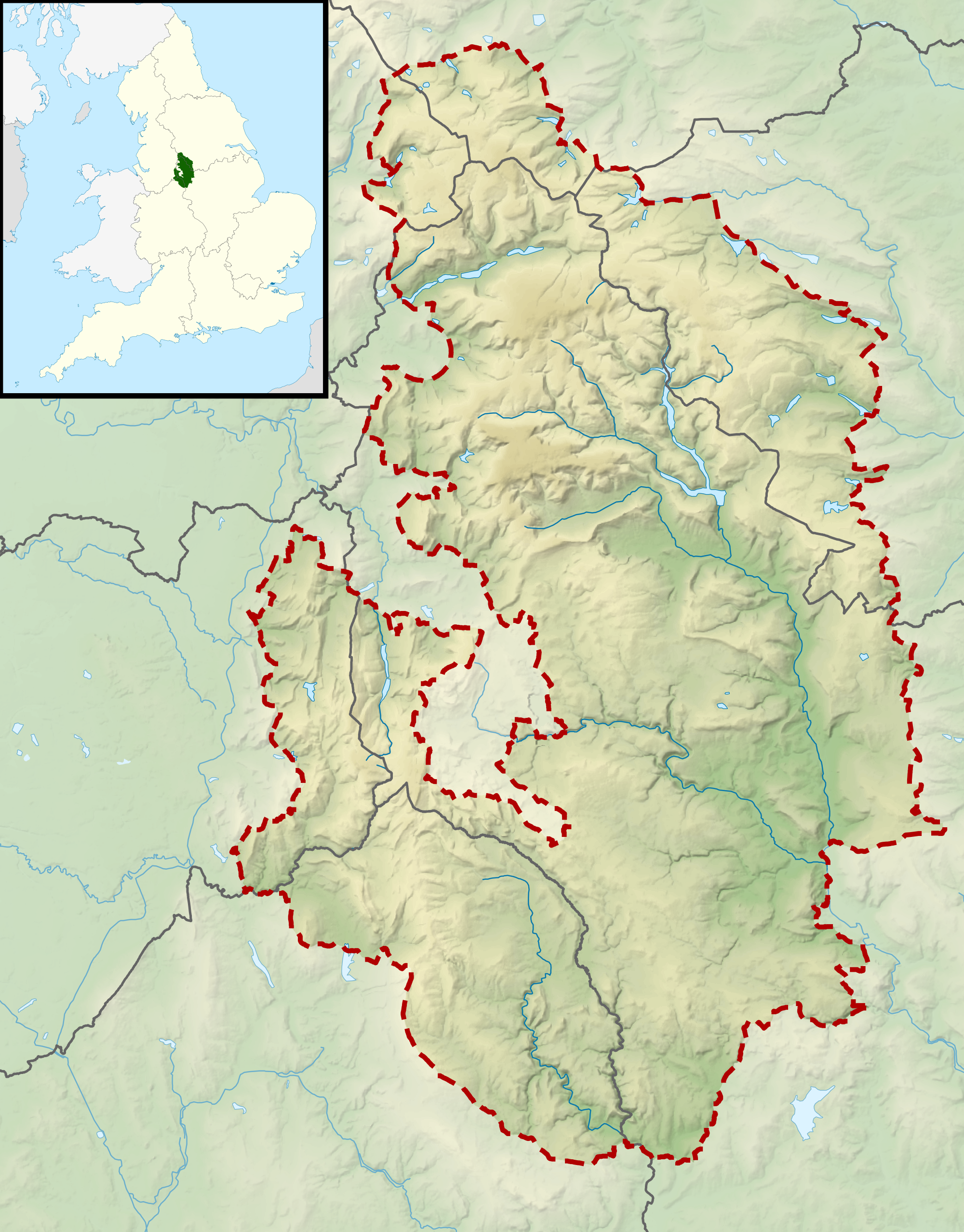
211:All other geographic data from Meridian 2 product.
330:https://creativecommons.org/licenses/by-sa/3.0
93:
757:{{Information |Description=Relief map of the
336:Creative Commons Attribution-Share Alike 3.0
254:
8:
205:Relief data from Land-Form Panorama product.
296:– to copy, distribute and transmit the work
911:
709:
362:
666:3076a395e7973f13c9a4a70f36527e217ce7fa93
929:
921:
913:
773:
664:
648:
630:
614:
593:
577:
556:
540:
519:
503:
485:
469:
449:
433:
413:
397:
380:
377:
358:
351:
7:
277:Attribution-Share Alike 3.0 Unported
235:, created using Ordnance Survey data
698:
265:
260:
904:
371:
365:
251:
125:
71:
370:
356:
307:Under the following conditions:
272:This file is licensed under the
264:
259:
253:
92:
21:
353:
14:
352:
26:
1:
183:Office of National Statistics
31:
378:Items portrayed in this file
871:Oliver Hill (Peak District)
191:National Park boundary data
951:
791:Black Hill (Peak District)
321:same or compatible license
931:File change date and time
699:
16:
355:
287:
216:England location map.svg
99:This is a file from the
756:
239:
228:
177:
170:
167:
130:
103:. Information from its
866:Mill Hill (Derbyshire)
106:description page there
41:Size of this preview:
915:Horizontal resolution
934:02:13, 12 March 2012
735:10:58, 17 March 2012
678:determination method
65:2,000 × 2,557 pixels
923:Vertical resolution
302:– to adapt the work
214:Inset derived from
148:Geographic limits:
47:Other resolutions:
801:Britland Edge Hill
142:National Park, UK
138:Relief map of the
61:801 × 1,024 pixels
938:
937:
764:
436:copyright license
364:
349:
348:
248:
245:Reusing this file
121:
120:
101:Wikimedia Commons
942:
912:
747:
687:
682:
598:
561:
524:
400:copyright status
343:
340:
337:
334:
331:
323:as the original.
285:
274:Creative Commons
268:
267:
263:
262:
257:
256:
242:
173:
134:
128:
117:
96:
95:
89:
83:
81:
68:
57:601 × 768 pixels
53:375 × 480 pixels
49:188 × 240 pixels
43:469 × 600 pixels
950:
949:
945:
944:
943:
941:
940:
939:
900:
821:Featherbed Moss
781:Black Chew Head
772:
765:
753:
745:
701:
700:
697:
696:
695:
694:
693:
692:
691:
690:
689:
688:
683:
680:
671:
670:
669:
667:
657:
656:
655:
653:
642:
641:
640:
639:
638:
637:
636:
635:
633:
623:
622:
621:
619:
608:
607:
606:
605:
604:
603:
602:
601:
599:
596:
586:
585:
584:
582:
571:
570:
569:
568:
567:
566:
565:
564:
562:
559:
549:
548:
547:
545:
534:
533:
532:
531:
530:
529:
528:
527:
525:
522:
512:
511:
510:
508:
497:
496:
495:
494:
493:
492:
491:
490:
488:
478:
477:
476:
474:
463:
462:
461:
460:
459:
458:
457:
456:
454:
442:
441:
440:
438:
427:
426:
425:
424:
423:
422:
421:
420:
418:
406:
405:
404:
402:
391:
390:
389:
388:
387:
385:
369:
368:
367:
350:
345:
344:
341:
338:
335:
332:
329:
328:
286:
283:
280:
269:
196:Ordnance Survey
132:
123:
122:
111:
110:
109:is shown below.
85:
79:
77:
70:
69:
46:
12:
11:
5:
948:
946:
936:
935:
932:
928:
927:
924:
920:
919:
916:
903:
899:
898:
893:
888:
883:
878:
873:
868:
863:
858:
853:
848:
843:
838:
833:
828:
826:Featherbed Top
823:
818:
813:
808:
803:
798:
793:
788:
783:
778:
770:
769:
768:
763:
762:
755:
751:
748:
744:2,000 × 2,557
742:
737:
732:
728:
727:
724:
721:
718:
715:
712:
705:
704:
676:
675:
674:
673:
672:
668:
665:
663:
662:
661:
660:
659:
658:
654:
649:
647:
646:
645:
644:
643:
634:
631:
629:
628:
627:
626:
625:
624:
620:
615:
613:
612:
611:
610:
609:
600:
594:
592:
591:
590:
589:
588:
587:
583:
578:
576:
575:
574:
573:
572:
563:
557:
555:
554:
553:
552:
551:
550:
546:
541:
539:
538:
537:
536:
535:
526:
520:
518:
517:
516:
515:
514:
513:
509:
504:
502:
501:
500:
499:
498:
489:
486:
484:
483:
482:
481:
480:
479:
475:
470:
468:
467:
466:
465:
464:
455:
450:
448:
447:
446:
445:
444:
443:
439:
434:
432:
431:
430:
429:
428:
419:
414:
412:
411:
410:
409:
408:
407:
403:
398:
396:
395:
394:
393:
392:
386:
381:
379:
376:
375:
374:
373:
372:
361:
360:
357:
354:
347:
346:
327:
326:
325:
324:
314:
305:
304:
303:
297:
290:You are free:
281:
271:
270:
252:
249:
237:
236:
230:
226:
225:
224:
223:
212:
209:
206:
193:
192:
179:
175:
174:
169:
165:
164:
163:
162:
159:
156:
153:
135:
126:
124:
119:
118:
97:
87:
86:
40:
36:
35:
34:
29:
24:
19:
13:
10:
9:
6:
4:
3:
2:
947:
933:
930:
925:
922:
917:
914:
910:
907:
901:
897:
894:
892:
889:
887:
884:
882:
879:
877:
874:
872:
869:
867:
864:
862:
859:
857:
854:
852:
849:
847:
844:
842:
839:
837:
834:
832:
829:
827:
824:
822:
819:
817:
814:
812:
809:
807:
804:
802:
799:
797:
794:
792:
789:
787:
784:
782:
779:
777:
776:Axe Edge Moor
774:
766:
760:
759:Peak District
754:
749:
743:
741:
738:
736:
733:
730:
729:
725:
722:
719:
716:
713:
711:
710:
708:
702:
686:
679:
652:
618:
581:
544:
507:
487:17 March 2012
473:
453:
437:
417:
401:
384:
333:CC BY-SA 3.0
322:
318:
315:
312:
309:
308:
306:
301:
298:
295:
292:
291:
289:
288:
282:Attribution:
278:
275:
258:
250:
246:
241:
238:
234:
231:
227:
221:
217:
213:
210:
207:
204:
203:
202:
200:
197:
190:
189:
188:
187:
184:
180:
176:
172:17 March 2012
166:
161:South: 53.00N
160:
158:North: 53.62N
157:
154:
151:
150:
149:
146:
143:
141:
140:Peak District
136:
129:
115:
108:
107:
102:
98:
91:
90:
84:
75:
74:Original file
66:
62:
58:
54:
50:
44:
39:
33:
30:
28:
25:
23:
20:
18:
15:
908:
905:
886:Thorpe Cloud
861:Merryton Low
856:Margery Hill
841:Kinder Scout
816:Derwent Edge
706:
703:File history
316:
310:
299:
293:
194:
181:
147:
144:
137:
114:You can help
104:
72:
22:File history
881:Shining Tor
876:Rushup Edge
811:Cheeks Hill
806:Brown Knoll
416:copyrighted
317:share alike
311:attribution
155:East: 1.50W
152:West: 2.30W
131:Description
836:Higger Tor
786:Black Edge
767:File usage
720:Dimensions
617:media type
521:3,485,931
240:Permission
27:File usage
926:187.8 dpc
918:187.8 dpc
752:Nilfanion
746:(3.32 MB)
717:Thumbnail
714:Date/Time
632:image/png
506:data size
472:inception
233:Nilfanion
186:Geography
80:image/png
902:Metadata
846:Lost Lad
831:Grin Low
796:Bleaklow
651:checksum
359:Captions
300:to remix
294:to share
279:license.
220:Spischot
199:OpenData
32:Metadata
851:Mam Tor
731:current
726:Comment
383:depicts
363:English
76:
595:2,000
558:2,557
543:height
229:Author
178:Source
685:SHA-1
597:pixel
580:width
560:pixel
723:User
523:byte
342:true
339:true
168:Date
17:File
218:by
681::
201:.
63:|
59:|
55:|
51:|
45:.
247:)
243:(
222:.
116:.
82:)
67:.
Text is available under the Creative Commons Attribution-ShareAlike License. Additional terms may apply.