173:
209:
151:
215:
220:
72:
565:
261:– You must give appropriate credit, provide a link to the license, and indicate if changes were made. You may do so in any reasonable manner, but not in any way that suggests the licensor endorses you or your use.
43:
634:
616:
164:
596:
442:
406:
611:
657:
This file contains additional information, probably added from the digital camera or scanner used to create or digitize it.
268:
496:
390:
83:
462:
426:
373:
51:
230:
336:
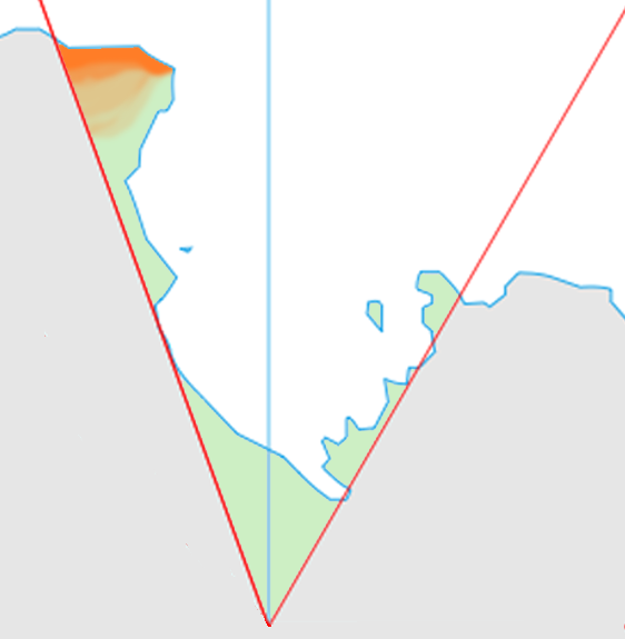
Location map of the
Pennell Coast in the Ross Dependency Generated from ] by ] by myself (]) {{cc-by-sa-2.5}}
660:
If the file has been modified from its original state, some details may not fully reflect the modified file.
172:
267:– If you remix, transform, or build upon the material, you must distribute your contributions under the
227:
575:
91:
330:
192:
564:
559:
188:
42:
601:
78:
606:
135:
150:
532:
Click on a date/time to view the file as it appeared at that time.
66:
644:
126:
Location map of the
Pennell Coast in the Ross Dependency
357:
Add a one-line explanation of what this file represents
301:
145:
110:
90:
Commons is a freely licensed media file repository.
443:
Creative
Commons Attribution-ShareAlike 2.5 Generic
304:. All following user names refer to en.wikipedia.
582:Transferred from en.wikipedia via #commonshelper
56:(562 × 575 pixels, file size: 50 KB, MIME type:
278:https://creativecommons.org/licenses/by-sa/2.5
71:
284:Creative Commons Attribution-Share Alike 2.5
208:
8:
244:– to copy, distribute and transmit the work
662:
534:
353:
306:
627:The following other wikis use this file:
672:
664:
594:
510:
494:
476:
460:
440:
424:
404:
388:
371:
368:
349:
342:
592:The following 5 pages use this file:
7:
523:
231:Attribution-Share Alike 2.5 Generic
219:
214:
655:
617:Template:PennellCoast-glacier-stub
362:
356:
300:The original description page was
299:
205:
165:Antarctica, territorial claims.svg
156:
120:
103:
49:
361:
597:Duke of York Island (Antarctica)
347:
255:Under the following conditions:
226:This file is licensed under the
218:
213:
207:
171:
149:
70:
31:
21:
344:
121:
46:No higher resolution available.
14:
612:Template:PennellCoast-geo-stub
343:
26:
1:
36:
369:Items portrayed in this file
694:
641:Usage on pl.wikipedia.org
631:Usage on ka.wikipedia.org
269:same or compatible license
524:
16:
346:
235:
77:This is a file from the
581:
560:14:01, 22 February 2021
184:
141:
134:
131:
113:
81:. Information from its
327:562×575× (51334 bytes)
84:description page there
666:Horizontal resolution
116:Pennell Coast map.png
52:Pennell_Coast_map.png
674:Vertical resolution
296:Original upload log
250:– to adapt the work
157:This file has been
681:
680:
623:Global file usage
585:
427:copyright license
355:
341:
340:
198:
197:
180:
179:
161:from another file
99:
98:
79:Wikimedia Commons
32:Global file usage
685:
663:
572:
391:copyright status
324:2011-08-04 01:10
307:
291:
288:
285:
282:
279:
271:as the original.
228:Creative Commons
222:
221:
217:
216:
211:
210:
175:
153:
146:
137:
125:
117:
111:
95:
74:
73:
67:
61:
59:
693:
692:
688:
687:
686:
684:
683:
682:
651:
621:
586:
578:
570:
526:
525:
522:
521:
520:
519:
518:
517:
516:
515:
513:
503:
502:
501:
499:
488:
487:
486:
485:
484:
483:
482:
481:
479:
469:
468:
467:
465:
454:
453:
452:
451:
450:
449:
448:
447:
445:
433:
432:
431:
429:
418:
417:
416:
415:
414:
413:
412:
411:
409:
397:
396:
395:
393:
382:
381:
380:
379:
378:
376:
360:
359:
358:
305:
298:
293:
292:
289:
286:
283:
280:
277:
276:
234:
223:
204:
199:
176:
162:
127:
115:
108:
101:
100:
89:
88:
87:is shown below.
63:
57:
55:
48:
47:
12:
11:
5:
691:
689:
679:
678:
675:
671:
670:
667:
654:
650:
649:
648:
647:
639:
638:
637:
635:პენელის ნაპირი
625:
624:
620:
619:
614:
609:
604:
599:
590:
589:
584:
583:
580:
576:
573:
567:
562:
557:
553:
552:
549:
546:
543:
540:
537:
530:
529:
514:
511:
509:
508:
507:
506:
505:
504:
500:
495:
493:
492:
491:
490:
489:
480:
477:
475:
474:
473:
472:
471:
470:
466:
461:
459:
458:
457:
456:
455:
446:
441:
439:
438:
437:
436:
435:
434:
430:
425:
423:
422:
421:
420:
419:
410:
405:
403:
402:
401:
400:
399:
398:
394:
389:
387:
386:
385:
384:
383:
377:
372:
370:
367:
366:
365:
364:
363:
352:
351:
348:
345:
339:
338:
333:
328:
325:
321:
320:
317:
314:
311:
297:
294:
275:
274:
273:
272:
262:
253:
252:
251:
245:
238:You are free:
225:
224:
206:
203:
200:
196:
195:
186:
182:
181:
178:
177:
170:
168:
154:
143:
139:
138:
133:
129:
128:
118:
109:
107:
104:
102:
97:
96:
75:
65:
64:
45:
41:
40:
39:
34:
29:
24:
19:
13:
10:
9:
6:
4:
3:
2:
690:
676:
673:
668:
665:
661:
658:
652:
646:
645:Pennell Coast
643:
642:
640:
636:
633:
632:
630:
629:
628:
622:
618:
615:
613:
610:
608:
605:
603:
602:Pennell Coast
600:
598:
595:
593:
587:
579:
574:
568:
566:
563:
561:
558:
555:
554:
550:
547:
544:
541:
538:
536:
535:
533:
527:
498:
478:4 August 2011
464:
444:
428:
408:
392:
375:
337:
334:
332:
329:
326:
323:
322:
318:
315:
312:
309:
308:
303:
295:
281:CC BY-SA 2.5
270:
266:
263:
260:
257:
256:
254:
249:
246:
243:
240:
239:
237:
236:
232:
229:
212:
201:
194:
190:
187:
183:
174:
169:
167:
166:
160:
155:
152:
148:
147:
144:
140:
136:4 August 2011
130:
124:
119:
112:
105:
93:
86:
85:
80:
76:
69:
68:
62:
53:
44:
38:
35:
33:
30:
28:
25:
23:
20:
18:
15:
659:
656:
626:
607:Waring Bluff
591:
531:
528:File history
335:
264:
258:
247:
241:
189:Lokal Profil
158:
122:
92:You can help
82:
50:
22:File history
407:copyrighted
265:share alike
259:attribution
114:Description
588:File usage
569:562 × 575
545:Dimensions
497:media type
313:Dimensions
27:File usage
677:28.35 dpc
669:28.35 dpc
542:Thumbnail
539:Date/Time
512:image/png
463:inception
310:Date/Time
202:Licensing
159:extracted
123:English:
58:image/png
653:Metadata
577:Szczureq
350:Captions
331:Grutness
319:Comment
248:to remix
242:to share
233:license.
193:Grutness
37:Metadata
571:(50 KB)
556:current
551:Comment
374:depicts
354:English
106:Summary
54:
185:Author
142:Source
548:User
316:User
302:here
290:true
287:true
132:Date
17:File
191:,
163::
94:.
60:)
Text is available under the Creative Commons Attribution-ShareAlike License. Additional terms may apply.


