314:
247:
239:
261:
282:
320:
325:
72:
692:"}},"text\/plain":{"en":{"":"heading"}}},"{\"value\":{\"amount\":\"+0\",\"unit\":\"http:\\\/\\\/www.wikidata.org\\\/entity\\\/Q28390\"},\"type\":\"quantity\"}":{"text\/html":{"en":{"P7787":"0
688:
372:– You must give appropriate credit, provide a link to the license, and indicate if changes were made. You may do so in any reasonable manner, but not in any way that suggests the licensor endorses you or your use.
1093:== {{int:filedesc}} == {{Information |Description={{en|1=Site of Roman Signal Station, Hadrian's Wall near Bankshead}} |Source=From |Date=2010-04-07 |Author=[http://www.geograph.org.uk/profile/361
230:
43:
689:
83:
51:
167:
809:
624:
588:
552:
254:
674:
1272:
289:
1153:
This file contains additional information, probably added from the digital camera or scanner used to create or digitize it.
1021:
379:
502:
971:
937:
900:
866:
829:
793:
730:
703:
637:
608:
536:
510:
495:
480:
759:
667:
652:
572:
453:
436:
1005:
276:
1175:
335:
1156:
If the file has been modified from its original state, some details may not fully reflect the modified file.
1125:
1107:
1309:
378:– If you remix, transform, or build upon the material, you must distribute your contributions under the
296:
on the
Geograph website for the photographer's contact details. The copyright on this image is owned by
332:
1075:
1070:
42:
1319:
696:"}},"text\/plain":{"en":{"P7787":"0 degree"}}}}": -->
91:
199:
1086:
659:
644:
487:
183:
1165:
1140:
1130:
260:
1379:
1291:
1182:
301:
78:
1389:
1222:
244:
1329:
135:
1202:
146:
156:
1192:
281:
293:
1043:
Click on a date/time to view the file as it appeared at that time.
246:
231:
54° 58′ 34.35″ N, 2° 39′ 28.85″ W
221:
66:
214:
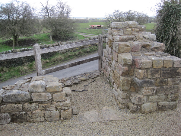
Site of Roman Signal
Station, Hadrian's Wall near Bankshead
195:
Site of Roman Signal
Station, Hadrian's Wall near Bankshead
126:
Site of Roman Signal
Station, Hadrian's Wall near Bankshead
420:
Add a one-line explanation of what this file represents
174:
Creative
Commons Attribution Share-alike license 2.0
110:
90:
Commons is a freely licensed media file repository.
589:
Creative
Commons Attribution-ShareAlike 2.0 Generic
56:(600 × 450 pixels, file size: 358 KB, MIME type:
1141:Forts et autres structures du mur d'Hadrien
389:https://creativecommons.org/licenses/by-sa/2.0
71:
395:Creative Commons Attribution-Share Alike 2.0
313:
8:
693:
355:– to copy, distribute and transmit the work
1158:
1126:Wikipedista:Phiwy/Pike Hill (signální věž)
1045:
416:
1118:The following other wikis use this file:
660:https://www.geograph.org.uk/photo/1835536
488:https://www.geograph.org.uk/profile/3612
1398:
1387:
1377:
1369:
1361:
1353:
1345:
1337:
1327:
1317:
1307:
1299:
1289:
1281:
1270:
1262:
1254:
1246:
1238:
1230:
1219:
1211:
1200:
1190:
1180:
1170:
1105:
1019:
1003:
985:
969:
951:
935:
914:
898:
880:
864:
843:
827:
807:
791:
773:
757:
717:
701:
622:
606:
586:
570:
550:
534:
467:
451:
434:
431:
412:
405:
224:
253:View this and other nearby images on:
1160:
7:
300:and is licensed for reuse under the
1103:The following page uses this file:
1034:
336:Attribution-Share Alike 2.0 Generic
324:
319:
304:Attribution-ShareAlike 2.0 license.
1151:
425:
419:
310:
287:
120:
116:Pike-Hill-Signal-Tower-Remains.jpg
103:
52:Pike-Hill-Signal-Tower-Remains.jpg
49:
424:
1213:Date and time of data generation
704:coordinates of the point of view
410:
366:Under the following conditions:
331:This file is licensed under the
323:
318:
312:
280:
259:
245:
237:
70:
31:
21:
407:
121:
46:No higher resolution available.
14:
625:file available on the internet
406:
288:This image was taken from the
26:
1:
1324:Flash did not fire, auto mode
719:54°58'34.345"N, 2°39'28.850"W
36:
675:Geograph Britain and Ireland
496:object of statement has role
432:Items portrayed in this file
1355:Focal plane resolution unit
1283:Date and time of digitizing
1420:
1137:Usage on fr.wikipedia.org
1122:Usage on cs.wikipedia.org
380:same or compatible license
236:
1256:File change date and time
1035:
16:
1347:Focal plane Y resolution
1339:Focal plane X resolution
1176:Canon DIGITAL IXUS 95 IS
810:Canon Digital IXUS 95 IS
638:geograph.org.uk image ID
409:
346:
77:This is a file from the
1363:Custom image processing
1092:
184:required by the license
162:
152:
141:
134:
131:
113:
81:. Information from its
1131:Signální věž Pike Hill
1108:Pike Hill Signal Tower
294:this photograph's page
265:54.976207; -2.658014
84:description page there
1240:Horizontal resolution
212:Les Hull /
193:Les Hull /
1187:1/320 sec (0.003125)
1286:14:31, 7 April 2010
1264:Y and C positioning
1259:14:31, 7 April 2010
1248:Vertical resolution
1216:14:31, 7 April 2010
1162:Camera manufacturer
361:– to adapt the work
1400:Scene capture type
1384:Auto white balance
1071:22:05, 25 May 2010
511:author name string
1407:
1406:
1114:Global file usage
1096:
695:
573:copyright license
418:
309:
308:
292:collection. See
270:
269:
219:
218:
187:
171:
168:Reusing this file
99:
98:
79:Wikimedia Commons
32:Global file usage
1411:
1350:15,116.022099448
1342:15,136.929460581
1159:
1083:
919:
848:
741:
740:
735:
677:
672:
662:
657:
653:described at URL
647:
642:
537:copyright status
518:
515:
505:
500:
490:
485:
402:
399:
396:
393:
390:
382:as the original.
344:
333:Creative Commons
327:
326:
322:
321:
316:
315:
302:Creative Commons
290:Geograph project
284:
277:
266:
263:
249:
248:
242:
241:
240:
234:
233:
222:
181:
165:
137:
125:
117:
111:
95:
74:
73:
67:
61:
59:
1419:
1418:
1414:
1413:
1412:
1410:
1409:
1408:
1147:
1112:
1097:
1089:
1081:
1037:
1036:
1033:
1032:
1031:
1030:
1029:
1028:
1027:
1026:
1024:
1012:
1011:
1010:
1008:
997:
996:
995:
994:
993:
992:
991:
990:
988:
978:
977:
976:
974:
963:
962:
961:
960:
959:
958:
957:
956:
954:
944:
943:
942:
940:
929:
928:
927:
926:
925:
924:
923:
922:
920:
917:
907:
906:
905:
903:
892:
891:
890:
889:
888:
887:
886:
885:
883:
873:
872:
871:
869:
858:
857:
856:
855:
854:
853:
852:
851:
849:
846:
836:
835:
834:
832:
821:
820:
819:
818:
817:
816:
815:
814:
812:
800:
799:
798:
796:
785:
784:
783:
782:
781:
780:
779:
778:
776:
766:
765:
764:
762:
751:
750:
749:
748:
747:
746:
745:
744:
743:
742:
738:
736:
733:
724:
723:
722:
720:
710:
709:
708:
706:
687:
686:
685:
684:
683:
682:
681:
680:
679:
678:
673:
670:
664:
663:
658:
655:
649:
648:
643:
640:
631:
630:
629:
627:
615:
614:
613:
611:
600:
599:
598:
597:
596:
595:
594:
593:
591:
579:
578:
577:
575:
564:
563:
562:
561:
560:
559:
558:
557:
555:
543:
542:
541:
539:
528:
527:
526:
525:
524:
523:
522:
521:
520:
519:
516:
513:
507:
506:
501:
498:
492:
491:
486:
483:
474:
473:
472:
470:
460:
459:
458:
456:
445:
444:
443:
442:
441:
439:
423:
422:
421:
404:
403:
400:
397:
394:
391:
388:
387:
345:
342:
339:
328:
305:
275:
264:
238:
229:
228:
225:Camera location
220:
209:
202:
190:
147:geograph.org.uk
127:
115:
108:
101:
100:
89:
88:
87:is shown below.
63:
57:
55:
48:
47:
12:
11:
5:
1417:
1415:
1405:
1404:
1401:
1397:
1396:
1393:
1386:
1385:
1382:
1376:
1375:
1372:
1368:
1367:
1366:Normal process
1364:
1360:
1359:
1356:
1352:
1351:
1348:
1344:
1343:
1340:
1336:
1335:
1332:
1326:
1325:
1322:
1316:
1315:
1312:
1306:
1305:
1302:
1298:
1297:
1294:
1288:
1287:
1284:
1280:
1279:
1276:
1269:
1268:
1265:
1261:
1260:
1257:
1253:
1252:
1249:
1245:
1244:
1241:
1237:
1236:
1233:
1229:
1228:
1225:
1218:
1217:
1214:
1210:
1209:
1206:
1199:
1198:
1195:
1189:
1188:
1185:
1179:
1178:
1173:
1169:
1168:
1163:
1150:
1146:
1145:
1144:
1143:
1135:
1134:
1133:
1128:
1116:
1115:
1111:
1110:
1101:
1100:
1095:
1094:
1091:
1087:
1084:
1078:
1073:
1068:
1064:
1063:
1060:
1057:
1054:
1051:
1048:
1041:
1040:
1025:
1020:
1018:
1017:
1016:
1015:
1014:
1013:
1009:
1004:
1002:
1001:
1000:
999:
998:
989:
986:
984:
983:
982:
981:
980:
979:
975:
970:
968:
967:
966:
965:
964:
955:
952:
950:
949:
948:
947:
946:
945:
941:
936:
934:
933:
932:
931:
930:
921:
915:
913:
912:
911:
910:
909:
908:
904:
899:
897:
896:
895:
894:
893:
884:
881:
879:
878:
877:
876:
875:
874:
870:
865:
863:
862:
861:
860:
859:
850:
844:
842:
841:
840:
839:
838:
837:
833:
828:
826:
825:
824:
823:
822:
813:
808:
806:
805:
804:
803:
802:
801:
797:
792:
790:
789:
788:
787:
786:
777:
774:
772:
771:
770:
769:
768:
767:
763:
758:
756:
755:
754:
753:
752:
729:
728:
727:
726:
725:
721:
718:
716:
715:
714:
713:
712:
711:
707:
702:
700:
699:
698:
697:
691:
666:
665:
651:
650:
636:
635:
634:
633:
632:
628:
623:
621:
620:
619:
618:
617:
616:
612:
609:source of file
607:
605:
604:
603:
602:
601:
592:
587:
585:
584:
583:
582:
581:
580:
576:
571:
569:
568:
567:
566:
565:
556:
551:
549:
548:
547:
546:
545:
544:
540:
535:
533:
532:
531:
530:
529:
509:
508:
494:
493:
479:
478:
477:
476:
475:
471:
468:
466:
465:
464:
463:
462:
461:
457:
452:
450:
449:
448:
447:
446:
440:
435:
433:
430:
429:
428:
427:
426:
415:
414:
411:
408:
386:
385:
384:
383:
373:
364:
363:
362:
356:
349:You are free:
340:
330:
329:
311:
307:
306:
285:
274:
271:
268:
267:
257:
251:
226:
217:
216:
210:
207:
204:
203:
198:
191:
188:
176:
175:
172:
160:
159:
154:
150:
149:
143:
139:
138:
133:
129:
128:
118:
109:
107:
104:
102:
97:
96:
75:
65:
64:
45:
41:
40:
39:
34:
29:
24:
19:
13:
10:
9:
6:
4:
3:
2:
1416:
1402:
1399:
1394:
1391:
1388:
1383:
1381:
1380:White balance
1378:
1374:Auto exposure
1373:
1371:Exposure mode
1370:
1365:
1362:
1357:
1354:
1349:
1346:
1341:
1338:
1333:
1331:
1328:
1323:
1321:
1318:
1313:
1311:
1310:Exposure bias
1308:
1303:
1301:APEX aperture
1300:
1295:
1293:
1292:Shutter speed
1290:
1285:
1282:
1277:
1274:
1271:
1266:
1263:
1258:
1255:
1250:
1247:
1242:
1239:
1234:
1231:
1226:
1224:
1220:
1215:
1212:
1207:
1204:
1201:
1196:
1194:
1191:
1186:
1184:
1183:Exposure time
1181:
1177:
1174:
1171:
1167:
1164:
1161:
1157:
1154:
1148:
1142:
1139:
1138:
1136:
1132:
1129:
1127:
1124:
1123:
1121:
1120:
1119:
1113:
1109:
1106:
1104:
1098:
1090:
1085:
1079:
1077:
1074:
1072:
1069:
1066:
1065:
1061:
1058:
1055:
1052:
1049:
1047:
1046:
1044:
1038:
1023:
1007:
973:
939:
902:
868:
831:
830:exposure time
811:
795:
794:captured with
761:
732:
705:
676:
669:
661:
654:
646:
639:
626:
610:
590:
574:
554:
538:
512:
504:
497:
489:
482:
455:
438:
392:CC BY-SA 2.0
381:
377:
374:
371:
368:
367:
365:
360:
357:
354:
351:
350:
348:
347:
341:Attribution:
337:
334:
317:
303:
299:
295:
291:
286:
283:
279:
278:
272:
262:
258:
256:
255:OpenStreetMap
252:
250:
232:
227:
223:
215:
211:
206:
205:
201:
197: /
196:
192:
185:
180:
178:
177:
173:
169:
164:
161:
158:
155:
151:
148:
144:
140:
130:
124:
119:
112:
105:
93:
86:
85:
80:
76:
69:
68:
62:
53:
44:
38:
35:
33:
30:
28:
25:
23:
20:
18:
15:
1390:Digital zoom
1223:focal length
1172:Camera model
1155:
1152:
1117:
1102:
1042:
1039:File history
901:focal length
775:7 April 2010
503:photographer
375:
369:
358:
352:
297:
235:
213:
200:CC BY-SA 2.0
194:
136:7 April 2010
122:
92:You can help
82:
50:
22:File history
1330:Color space
1232:Orientation
1088:Nick Ottery
1006:instance of
553:copyrighted
376:share alike
370:attribution
179:Attribution
114:Description
1099:File usage
1080:600 × 450
1056:Dimensions
1022:photograph
987:image/jpeg
972:media type
918:millimetre
469:some value
163:Permission
58:image/jpeg
27:File usage
1203:ISO speed
1053:Thumbnail
1050:Date/Time
938:ISO speed
845:0.003125
760:inception
273:Licensing
208:InfoField
189:InfoField
123:English:
1403:Standard
1267:Centered
1193:F-number
1149:Metadata
1082:(358 KB)
867:f-number
668:operator
517:Les Hull
413:Captions
359:to remix
353:to share
343:Les Hull
338:license.
298:Les Hull
157:Les Hull
37:Metadata
1304:2.96875
1275:version
1251:180 dpi
1243:180 dpi
1067:current
1062:Comment
731:heading
690:heading
645:1835536
454:creator
437:depicts
417:English
106:Summary
54:
1358:inches
1296:8.3125
1235:Normal
1227:6.2 mm
1205:rating
847:second
739:degree
694:degree
243:
153:Author
142:Source
1392:ratio
1320:Flash
1221:Lens
1197:f/2.8
1166:Canon
145:From
1334:sRGB
1273:Exif
1059:User
916:6.2
401:true
398:true
132:Date
17:File
1278:2.2
1208:160
953:160
882:2.8
481:URL
737:0
734::
671::
656::
641::
514::
499::
484::
1395:1
1314:0
186:)
182:(
170:)
166:(
94:.
60:)
Text is available under the Creative Commons Attribution-ShareAlike License. Additional terms may apply.
